National Weather Service United States Department of Commerce


Comparison of green versus brown, Mid May to Mid March 2013, in Brownsville
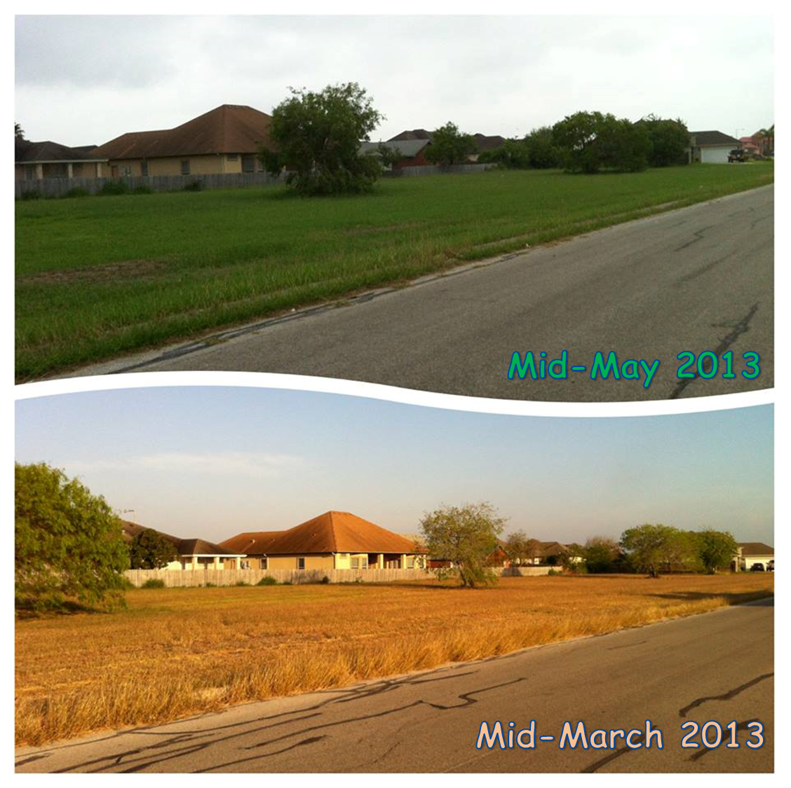
Photo comparison in Brownsville, showing green grass (top) in mid–May where there was no growth just two months earlier
Green Grasses, Growing Gardens
Second Valley Wide Rainfall in Two Weeks "Springs" Plants to Life
...But Hot, Rain–Free Conditions Return to Close May 2013

Event Summary
A series of weak upper level disturbances ejected from the base of a flat trough of low pressure that meandered in northwest Mexico between May 10th and 14th, before ejecting into the southern Plains on the 15th (below). Each disturbance produced some rainfall across the Rio Grande Valley, South Texas Brush Country, and Rio Grande Plains. The heaviest rains fell late on the 10th through early morning of the 11th, as outflows from strong to severe storms across the Big Bend surged into the Rio Grande Plains. For the second time in two weeks, rains flooded Laredo and Nuevo Laredo; the rapid rainfall rate overnight on May 10th/11th left "Laredo Morning Times article on deaths and homelessness from May 10/11 Flooding" 4 persons dead and thousands homeless in Nuevo Laredo. Torrential rains and some hail smacked Zapata County shortly after midnight on the 11th; the storms continued into Starr County before weakening in Hidalgo County, then reintensified in southeast Hidalgo County and Cameron County. The initial surge of rain dropped between 1 and 2.5 inches in Zapata County, and 2 to 3 inches in a band from near Weslaco through Harlingen, Raymondville, and Port Isabel (top right).

The initial thrust of rain was followed by additional rainfall each evening and overnight across different parts of Deep South Texas through very early on May 15th. Steady light rain with embedded thunder returned late on the 11th (bottom right) and early on the 12th as energy provided lift to the north of the front which had passed early on the 11th. Additional light rain fell in Cameron County during the evening of the 12th, with heavier rain and some thunder across the ranchlands of Jim Hogg and Starr County. Most of the Valley stayed dry on the 13th and early on the 14th, but a band of moderate rain slid from the foothills of the Sierra Madre near Monterrey into southwestern Starr and Zapata County. One final band of showers and thunderstorms passed across the Rio Grande Plains and Ranchlands north of the RGV from near midnight to the wee hours of May 15th as the persistent upper level system lifted into the southern Plains, taking the final disturbance with it.

The additional rainfall across formerly parched sections of the Rio Grande Plains and Ranchlands added up to a general 2 to 4 inch total for the period; some spots in southern Jim Hogg County may have touched 6 inches for the two rain periods that began on April 27th. While the Rio Grande Plains and Ranchlands of Zapata, Jim Hogg, Starr, and some of Brooks County benefited, the "dead zone" of southeast Starr and western Hidalgo County missed the action – AGAIN. Less than two inches fell from Mission to La Joya and towns in between; these locations have been among the lowest rain totals across the region since the dry period began in October 2010.

Unsettled jet stream pattern that produced cloudy, occasionally stormy, and cool weather between May 11th and 15th, 2013
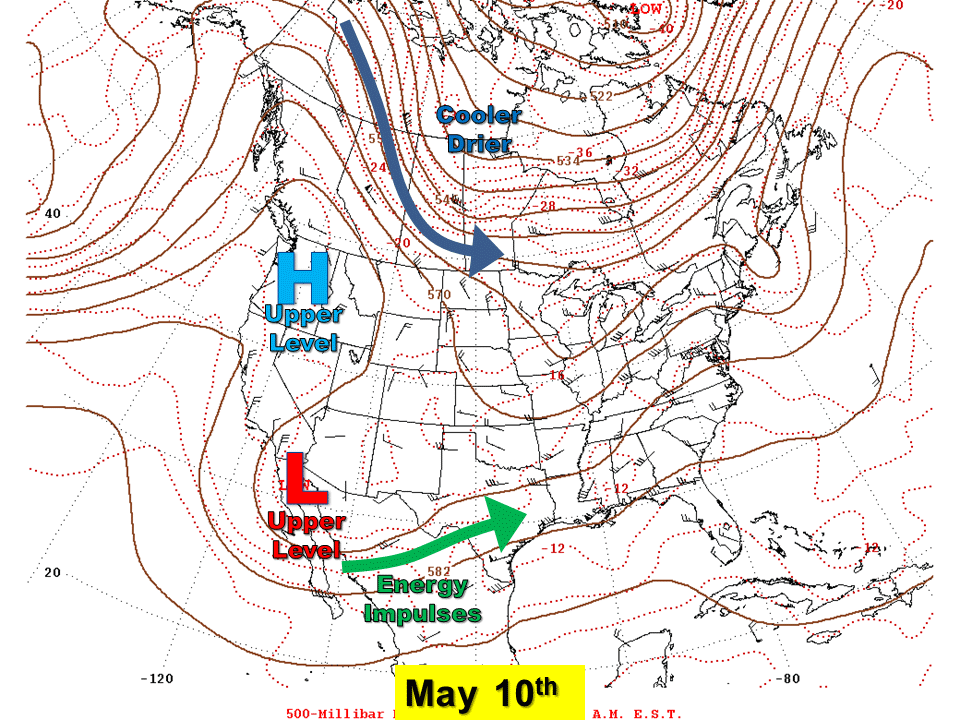
Animation of pressure systems in the "jet stream" level (around 18,000 feet in this case) between May 10th and 15th, 2013. Disturbances ejecting from the persisting area of low pressure in northern Mexico produced rain for some of the Rio Grande Valley/Deep South Texas region through May 15th. The system itself weakened and lifted into the Southern Plains on the 15th, taking the rain and cool weather with it (click to enlarge).
Animation of reintensifying line of thunderstorms that moved into Cameron County Texas during the pre dawn hours of May 11th 2013
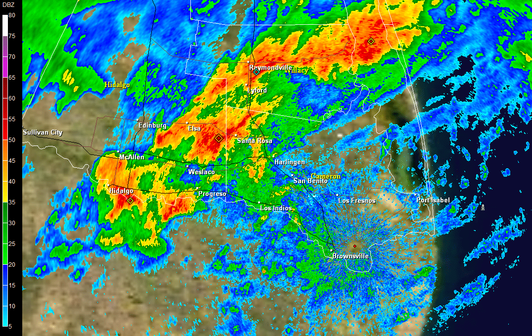
Animation of 0.5° base reflectivity from NWS Brownsville/Rio Grande Valley, between 4 and 5 AM on May 11th. Thunderstorms re–intensified across Cameron County, dropping between 2 and 3 inches in some locations west of Harlingen (click to enlarge).

Animation of steady light to moderate rains across eastern Hidalgo and Cammeron County shortly after midnight of May 12th 2013
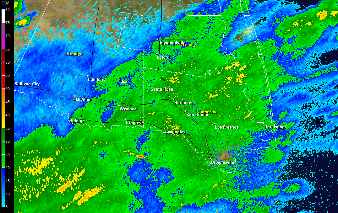
Animation of 0.5° base reflectivity from NWS Brownsville/Rio Grande Valley, between 1 and 2 AM on May 12th. Steady light rain, with embedded moderate rain and some lightning and thunder, covered eastern Hidalgo and Cameron County and dropped up to 0.25 inch in some areas (click to enlarge).

Preliminary partial rainfall totals from late evening May 10th through 7 AM on May 14th, 2013, for the Rio Grande Valley and Deep South Texas
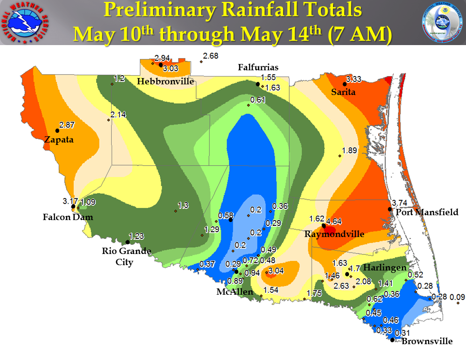
Preliminary rainfall map for period May 10th through 7 AM May 14th. Additional rainfall from midnight through early morning on May 15th is not included (click to enlarge).
 

How Now, Drought?
The rains of late April and early May were beneficial, but far from necessary to alleviate the drought, which had lasted for more than two years. For western Hidalgo and southeastern Starr County, the lower rain totals ensured Exceptional (D4, worst level) would continue as dry, hot conditions appeared to close May 2013. Cameron and Willacy County were unable to improve beyond the Extreme (D3) level, despite pockets of more than 6 inches of rain. The most "improvement" was across the Rio Grande Plains and Ranchlands of Jim Hogg, northern Starr, and Zapata County, where the locally estimated and measured 4 to 6 inches accounted for 25 to 33 percent of the annual rainfall and made a slight, though temporary, dent in the drought, improving from Exceptional to Severe (D2) in just a few weeks. Unfortunately, reservoir recovery was limited at Falcon, which remained around one quarter of conservation; larger Amistad reservoir had fallen to one half its level in May 2013 compared with May 2012. The US Drought Monitor as of May 14th is shown at the end of this article.

Rainfall for the Rio Grande Valley/Deep South Texas, April 27th through early May 15th, 2013
Note: Edited areas on Jim Hogg/northern Starr County, and southeast Hidalgo County, is based on bias corrected radar estimates (click to enlarge).
 
Preliminary rainfall data from 7 PM April 27th through 7 AM May 15th
City/Town
County
Report Type
Rainfall
Raymondville 2.0 SSW
Willacy
CoCoRaHS
6.96
Harlingen 4.7 miles WSW
Cameron
CoCoRaHS
6.66
Harlingen 4.3 miles WSW
Cameron
CoCoRaHS
6.25
San Benito 0.6 miles SSE
Cameron
CoCoRaHS
5.81
Sarita 7 miles E
Kenedy
Cooperative
5.77
Hebbronville
Jim Hogg
RAWS
5.16
Harlingen 2.6 miles ESE
Cameron
CoCoRaHS
4.94
Harlingen
Cameron
Cooperative
4.71
Hebbronville
Jim Hogg
Cooperative
4.67
Zapata/Medina County Airport
Zapata
AWOS
4.46
Jim Hogg County Airport
Jim Hogg
AWOS
4.38
Raymondville
Willacy
Cooperative
4.21
Falcon Dam
Starr
Cooperative
4.13
Harlingen/Valley International Airport
Cameron
ASOS
4.00
Weslaco/Mid Valley Airport
Hidalgo
AWOS
3.97
Rancho Viejo 3.0 miles SE
Cameron
CoCoRaHS
3.90
Port Mansfield
Willacy
Cooperative
3.89
Lower Rio Grande Valley NWR/Santa Ana
Hidalgo
RAWS
3.85
Brownsville 6.4 miles WNW
Cameron
CoCoRaHS
3.82
San Benito 7.8 miles E
Cameron
CoCoRaHS
3.79
Alamo 1.5 miles NNE
Hidalgo
CoCoRaHS
3.79
La Feria 1.3 miles ENE
Cameron
CoCoRaHS
3.75
Los Fresnos 0.3 miles NE
Cameron
CoCoRaHS
3.66
Brownsville 5.0 miles NW
Cameron
CoCoRaHS
3.56
Rancho Viejo 0.7 miles E
Cameron
CoCoRaHS
3.41
Brownsville 1.9 miles ESE
Cameron
CoCoRaHS
3.33
Laredo Int'l Airport
Webb
ASOS
3.31
Rio Grande City 17.7 miles NE
Starr
CoCoRaHS
3.30
Brownsville 0.1 miles SSE
Cameron
CoCoRaHS
3.23
Brownsville 2.3 miles NW
Cameron
CoCoRaHS
3.07
Brownsville/South Padre Island Int'l Airport
Cameron
ASOS
3.02
Brownsville 4.1 miles ENE
Cameron
CoCoRaHS
3.02
La Joya 11.1 miles N
Hidalgo
CoCoRaHS
3.02
Brownsville 6.4 miles SE (Sabal Palms)
Cameron
CoCoRaHS
2.92
Falfurrias 0.5 miles WNW
Brooks
CoCoRaHS
2.87
Laguna Atascosa NWR
Cameron
RAWS
2.79
Brooks County Airport
Brooks
AWOS
2.79
Falcon Lake
Starr
RAWS
2.60
Brownsville 2.2 miles W
Cameron
CoCoRaHS
2.52
Hebbronville 17.6 miles WSW
Jim Hogg
CoCoRaHS
2.41
Lower Rio Grande Valley NWR/Linn-San Manuel
Hidalgo
RAWS
2.40
Edinburg 0.8 miles ENE
Hidalgo
CoCoRaHS
2.30
Rio Grande City 2.8 miles W
Starr
CoCoRaHS
2.29
Falfurrias 8.9 miles SSW
Brooks
CoCoRaHS
2.19
McAllen/Miller Airport
Hidalgo
ASOS
2.06
South Padre Island 1.1 miles N
Cameron
CoCoRaHS
1.95
McAllen
Hidalgo
Cooperative
1.91
McAllen 2.4 miles NE
Hidalgo
CoCoRaHS
1.90
San Manuel
Hidalgo
Cooperative
1.80
Bayview/Cameron County Airport
Cameron
ASOS
1.76
Edinburg International Airport
Hidalgo
AWOS
1.69
Port Isabel
Cameron
Cooperative
1.68
Edinburg
Hidalgo
Cooperative
1.50
La Joya
Hidalgo
Cooperative
1.48
Mission 1.9 miles ENE
Hidalgo
CoCoRaHS
1.28

*AWOS = Automated Weather Observing System
*ASOS = Automated Surface Observing System
*CoCoRaHS = Community Collaborative Rain, Hail, and Snow Network
*Cooperative = Cooperative Climate Network
*RAWS = Remote Automated Weather System


Rio Grande Valley Drought Monitor as of May 14th, 2013
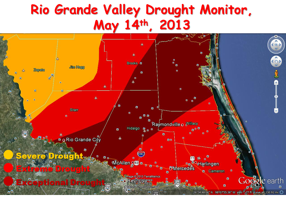
Image of the U.S. Drought Monitor zoomed to the Rio Grande Valley as of May 14th, 2013 (click to enlarge).