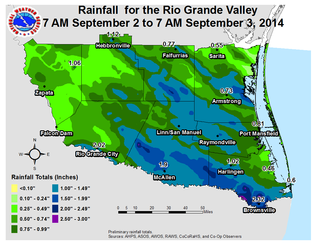
 Measured and estimated rainfall during peak of Tropical Storm Dolly’s Outer Bands. Click to enlarge. |
 Green grass and brush makes a welcome return to much of the Rio Grande Valley. Photo taken in Brownsville on September 8, 2014 |
||||||||||||||||||||||||||||||||||||||||||||||||||||||||||||||||||||||||||||||||||||||||||||||||||||||||||||||||||||||||||||||||||||||||||||||||||||||||||||||||||||||||||||||||||||||||||||||||
| "Baby Dolly" Brings Welcome Rain to Thirsty Rio Grande Valley Green Grass and Brush Returns after a Brown July and August 2014 |
|||||||||||||||||||||||||||||||||||||||||||||||||||||||||||||||||||||||||||||||||||||||||||||||||||||||||||||||||||||||||||||||||||||||||||||||||||||||||||||||||||||||||||||||||||||||||||||||||
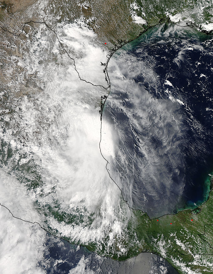 Visible satellite photo of Tropical Storm Dolly’s remnants moving into northeast Tamaulipas at 230 PM CDT, September 3 2014. Convergent band of heavy rain was dissipating across South Texas at this time. While helpful rainfall from a weak tropical disturbance on August 29–30 began to turn areas of brown to green across portions of the Lower and Mid Rio Grande Valley and especially the King Ranch, an elongated tropical wave was trekking through the western Caribbean Sea, headed for the Yucatan Peninsula late in the Labor Day Weekend (August 31–September 1). After emerging in the Bay of Campeche on the first, 2014 Atlantic Tropical Depression Number 5 was born; during the pre–dawn hours of the 2nd, winds around the east and southeast side of the cyclone were sufficient to name the system Tropical Storm Dolly. "Baby Dolly" not to be confused with the memorable Hurricane Dolly of 2008, would struggle to organize through the 2nd, but finally would do so by evening as it crossed the coast near Tampico, Tamaulipas, MX at around 10 PM. |
Though "Baby Dolly" caused some notable flooding in eastern and central Tamaulipas, with over 200 homes affected in Cabo Rojo and at least one known fatality (as of the 9th), the outer "arms" from the cyclone, in the form of a convergent band of torrential rains, dropped a quenching 1 to 2+ inches of rain (top image and bottom table) across the entire Rio Grande Valley from early morning through mid afternoon. The rains produce some expected urban flooding of a few poor drainage locations, with briefly up to 2 feet of water depth around Brownsville and Edinburg, and up to six roads closed in McAllen in a near 10th Street. Elsewhere, the rain was welcomed by farmers and gardeners alike; the warm–core process of tropical cyclone type rain quickly turned most locations into lush tropical landscapes in Hidalgo, southern Willacy, and Cameron County. Many ranches also greened up, but pockets of Jim Hogg and Starr County missed the heaviest rains and would remain in severe drought conditions. Influence from outer bands radiating from the remnants of "Baby Dolly" that moved into southern Nuevo Leon continued to produce scattered mainly late night through early afternoon showers and thunderstorms on September 4th and 5th. Additional rains fell in the more usual September sea breeze pattern during the late morning and early afternoon of the 6th and 7th, and are not shown. 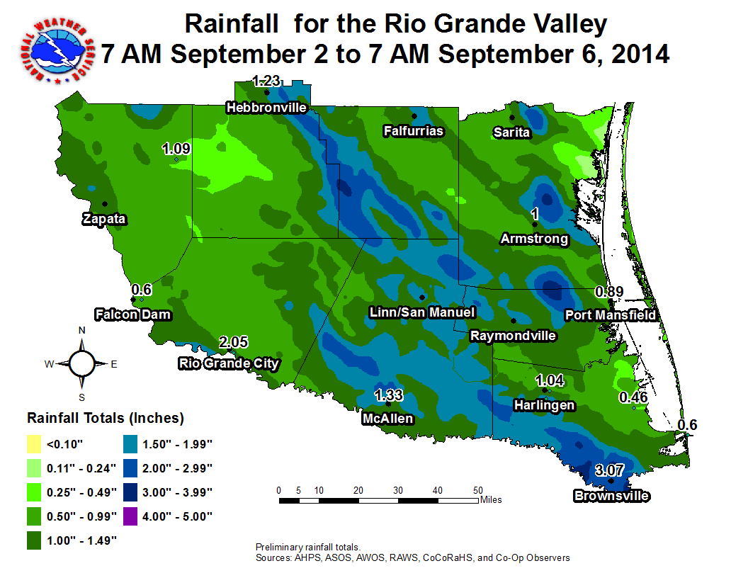 |
||||||||||||||||||||||||||||||||||||||||||||||||||||||||||||||||||||||||||||||||||||||||||||||||||||||||||||||||||||||||||||||||||||||||||||||||||||||||||||||||||||||||||||||||||||||||||||||||
 Composite Reflectivity loop from 921 AM to 11 AM CDT September 3, 2014, across the Rio Grande Valley during period of peak rainfall intensity. Image source: Plymouth State University NEXRAD Information Dissemination Service page. |
|||||||||||||||||||||||||||||||||||||||||||||||||||||||||||||||||||||||||||||||||||||||||||||||||||||||||||||||||||||||||||||||||||||||||||||||||||||||||||||||||||||||||||||||||||||||||||||||||
|
|||||||||||||||||||||||||||||||||||||||||||||||||||||||||||||||||||||||||||||||||||||||||||||||||||||||||||||||||||||||||||||||||||||||||||||||||||||||||||||||||||||||||||||||||||||||||||||||||


 Follow us on YouTube