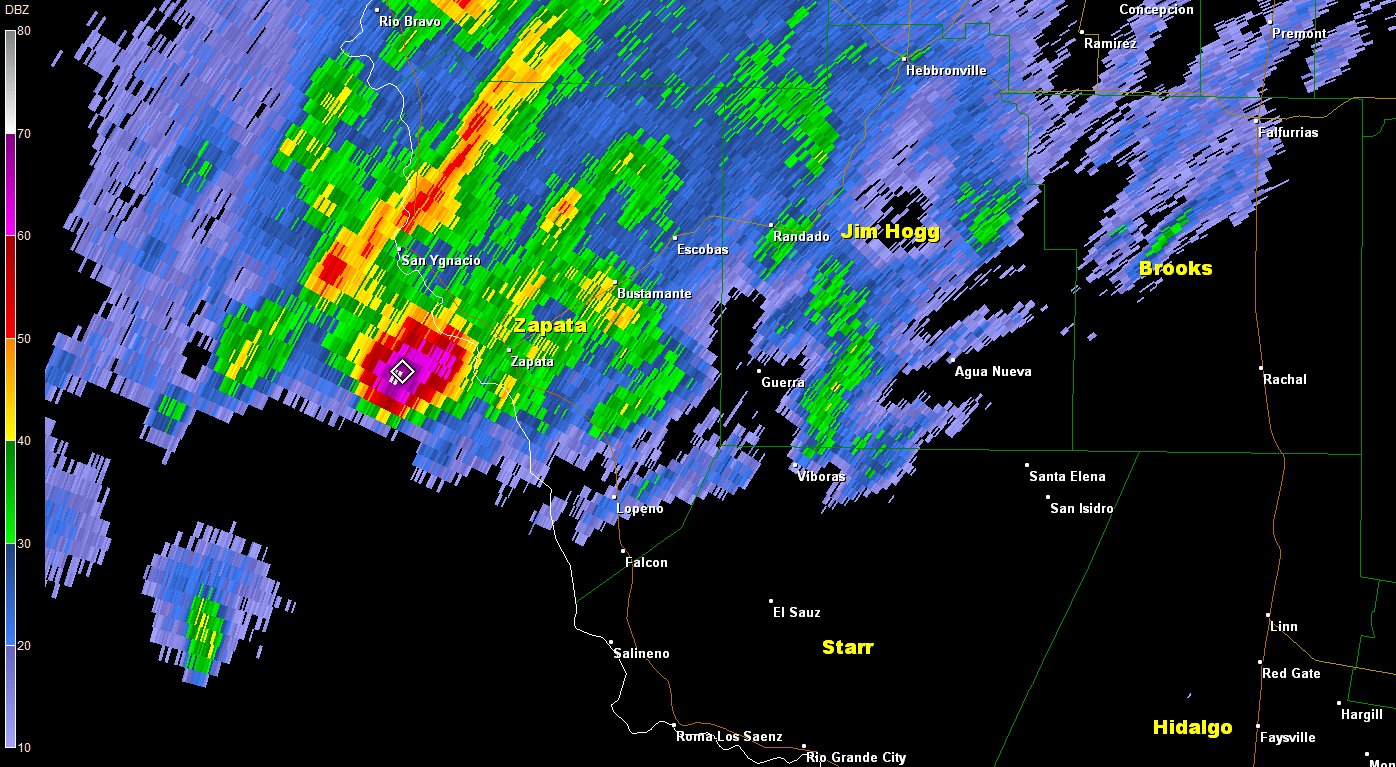
 Radar of supercell storm that dropped large hail and produce wind damage in Zapata (city) before moving across the Zapata and Jim Hogg County ranchlands November 22, 2014. |
|
| Hail, Wind Rake Zapata; More Rain Falls on Rio Grande Valley Rough Weather Strikes (Again) on November 22 (2014) |
|
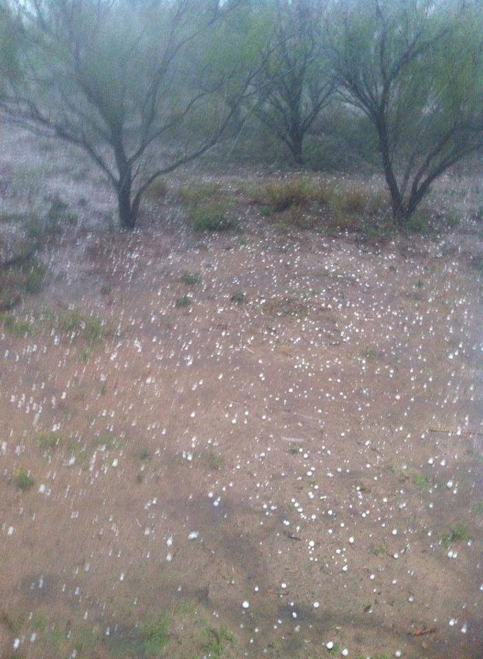 Quarter to ping–pong ball sized hail covers ground in Zapata, TX, during late afternoon of November 22, 2014. Photo credit: KIII ABC Channel 3, Corpus Christi (via social media). Exactly one year on from another notable weather event, the atmosphere on November 22, 2014, did not disappoint. A potent upper level disturbance tracked from southern California into Chihuahua State, Mexico, from the 21st through early on the 22nd, before slicing through South and Central Texas prior to weakening over East Texas by daybreak on the 23rd. Unstable air (shown in some part by this sounding issued around noon on the 22nd) that lifted along the Sierra Madre kicked off individual supercell thunderstorms in the lee of the mountains west of the Rio Grande Plains after 3 PM; these cells scooted east at 35 mph, and one would slam through Zapata County between 515 and 6 PM. Hail up to golfball size and estimated winds of 65 to 70 mph (damage photo at right) occurred with this particular storm. 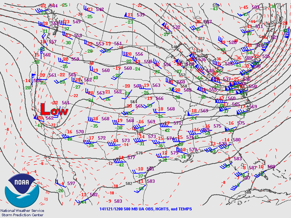 Steering pattern at around 18,000 feet (500 mb) across the U.S. between 6 PM November 21 and 6 AM November 23, showing vigorous upper level disturbance (Low) that impacted Texas and the Deep South U.S. November 22 and 23. |
The Zapata storm gradually weakened as it moved into the Jim Hogg County ranchlands. Though weakening, an estimated 2 to 3 inches of rain fell in central Jim Hogg, nearly twice the average of November in just a couple of hours! The upper level disturbance and boundaries from earlier storms aided the development of clusters of thunderstorms farther east, including much of the Rio Grande Valley, between 7 and 9 PM. A squall line began to develop as the activity first reached the coast just before 9 PM, and a wind gust to 56 mph was reported along the Laguna Madre in Kenedy County just after 830 PM. The line extended south to near Port Mansfield, and would soon solidify over the Gulf waters as it raced along between 9 PM and 11 PM. Additional storm clusters developed behind the initial push, with some producing wind gusts near 40 mph, as well as nearly 2 inches of rain in Harlingen. The Valley may have pulled a "Houdini" once again in avoiding significant severe weather in the form of damaging winds and/or hail. The atmospheric profile at 6 PM November 22 indicated just enough stability to quash the potential for a notable event. The stability was provided by just enough air that warmed up and dried out around 5000 feet after descending east of the Sierra Madre, "capping" the ability of surface air to rise and explode into much more dangerous thunderstorms. Lack of solar heating may have helped as well. As the upper level disturbance headed toward East Texas, rain quickly ended and skies cleared. Widespread dense fog formed across Deep South Texas before daybreak and resulted in difficult driving conditions for early risers and churchgoers on the 23rd.  Photo of uprooted trees that caused some home and fence damage in Zapata between 515 and 530 PM on November 22, 2014. |
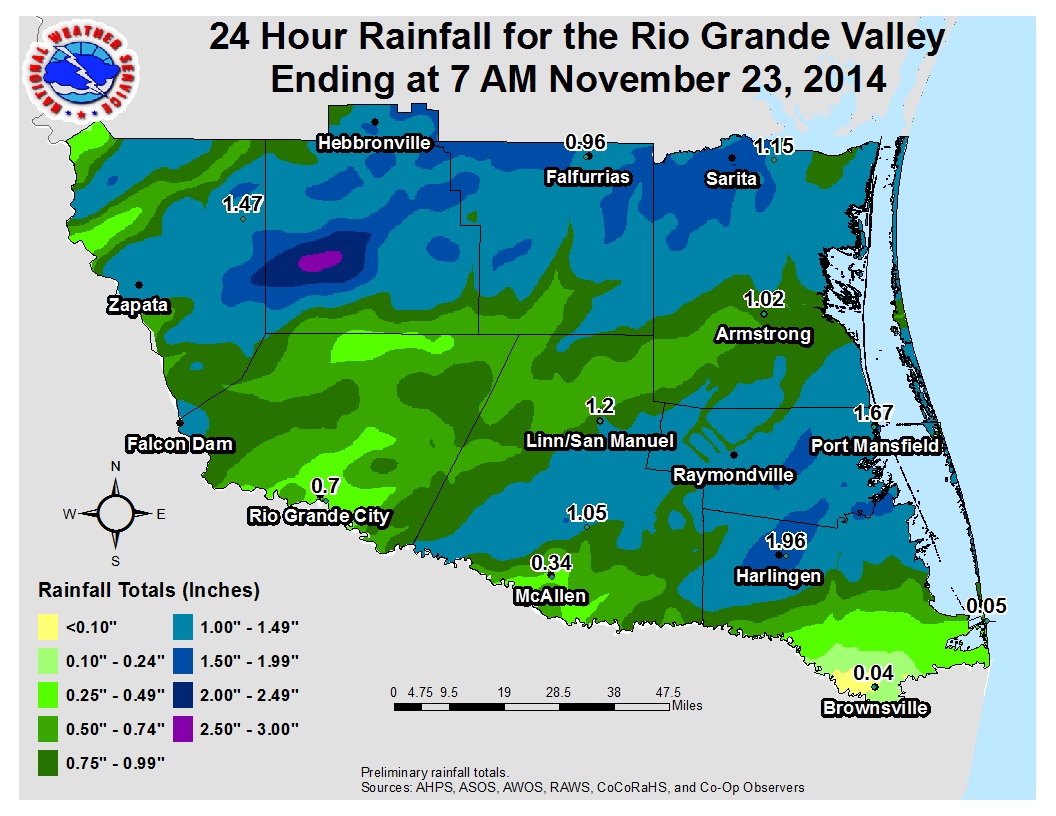 Measured and estimated rainfall, November 22, 2014, across the Rio Grande Valley and Deep South Texas.
PRELIMINARY LOCAL STORM REPORT...SUMMARY
NATIONAL WEATHER SERVICE BROWNSVILLE TX
1107 AM CST MON NOV 24 2014

..TIME...   ...EVENT...      ...CITY LOCATION...     ...LAT.LON...
..DATE...   ....MAG....      ..COUNTY LOCATION..ST.. ...SOURCE....
            ..REMARKS..

0520 PM     TSTM WND DMG     ZAPATA                  26.89N  99.26W
11/22/2014                   ZAPATA             TX   LAW ENFORCEMENT

            ROOF DAMAGE TO A HOUSE NEAR THE INTERSECTION OF 5TH AND
            HIDALGO IN ZAPATA.

0520 PM     TSTM WND DMG     ZAPATA                  26.89N  99.26W
11/22/2014                   ZAPATA             TX   LAW ENFORCEMENT

            ZAPATA COUNTY SHERIFFS OFFICE REPORTS NUMEROUS TREES
            AND POWER LINES DOWN IN THE TOWN OF ZAPATA.

0520 PM     TSTM WND DMG     ZAPATA                  26.89N  99.26W
11/22/2014                   ZAPATA             TX   EMERGENCY MNGR

            EMERGENCY MANAGER REPORTS A FEW OLDER HOUSES HAD ROOFS
            PARTIALLY REMOVED SEVERAL METAL BUILDINGS TRAILERS HAD
            ROOFS TOTALLY REMOVED...A CHAIN LINK FENCE WAS BLOWN
            DOWN...NUMEROUS TREES AND POWERLINES WERE BLOWN DOWN
            THROUGH THE CITY AND A LARGE OBJECT BLEW OFF OF A
            CONSTRUCTION SITE AT THE COURTHOUSE AND DAMAGED NEARBY
            OBJECTS. HAIL TO AROUND PING PONG BALL SIZE WAS ALSO
            DOCUMENTED. WIND SPEEDS ESTIMATED AT 65-70 MPH.

0522 PM     HAIL             ZAPATA                  26.89N  99.26W
11/22/2014  E1.00 INCH       ZAPATA             TX   LAW ENFORCEMENT

0522 PM     TSTM WND GST     ZAPATA                  26.89N  99.26W
11/22/2014  E60 MPH          ZAPATA             TX   LAW ENFORCEMENT

0836 PM     MARINE TSTM WIND 18 N PORT MANSFIELD     26.81N  97.48W
11/22/2014  M57 MPH          GMZ135             TX   UNKNOWN

            WIND GUST OF 49 KNOTS REPORT BY THE TCOON SITE AT
            RINCON DEL SAN JOSE AT 836 PM.

1000 PM     MARINE TSTM WIND 52 ENE PORT MANSFIELD   26.92N  96.70W
11/22/2014  M45 MPH          GMZ175             TX   BUOY

            BUOY020 REPORTED A WIND GUST TO 39 KNOTS AT 10 PM.
|
|


 Follow us on YouTube