 Loop of Composite Reflectivity from noon through 2 PM March 26th, for single severe thunderstorm that tracked across Hidalgo County, Texas. Frames with pink/magenta color correlated to quarter to golfball sized hail fall. |
|
| Solo Severe Thunderstorm Strikes Fear in Hidalgo County, March 26, 2015 Short Duration Large Hail Burst Brings Back Memories of 2012 |
|
 Hail photos shared on the NWS Brownsville Facebook Page from the Citrus City/Alton/Mission/McAllen area of Hidalgo County Nearly three years to the day (March 29, 2012), the fear of hail arrived in the McAllen metro area, courtesy of a single severe thunderstorm that developed quickly in rural eastern Starr County and roared into western Hidalgo County near Citrus City before racing through the cities of Alton/Mission, Edinburg/McAllen/Pharr and steadily weakening between Alamo and Donna. Unlike the hell of March 29, 2012, the storm of March 26, 2015 came in broad daylight (lunchtime) and dwelled briefly, with five to ten minutes of hailfall at any one location compared with the 45 minutes to one hour ravaging event in 2012. The largest hail ranged from half–dollar size to golf ball size in Mission, Alton, and Palmhurst (west McAllen) between 1 and 115 PM. Some of the stones had jagged edges, able to strip siding on some homes in these areas, cause minor dents/dings to vehicles, and crack an unknown number of windshields caught in the worst. The initial burst of hail came with 60 to 65 mph winds, which removed a poorly anchored roof of trailer home in Alton, and blew down some power lines and healthy large mesquite limbs. Winds dropped a bit as the cell moved over McAllen, reaching gusts of 43 mph at Miller Airport; lower gusts of little consequence occurred farther east in the Mid Valley before the storm weakened further. 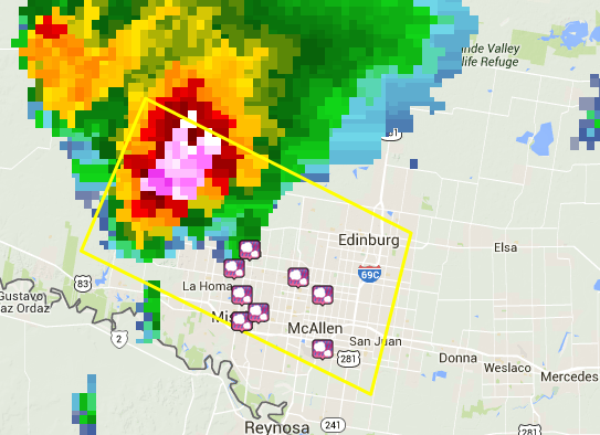 Initial severe thunderstorm warning issued at 1245 PM March 26 (yellow box), which included wording for damaging 70 mph wind and two inch diameter hailstones. Icons in the warning box are hail reports, between 1 and 130 PM; multicolored cluster is the severe storm as it moved into the warning box area. Damaging wind event described above was not included in prelminary storm report. |
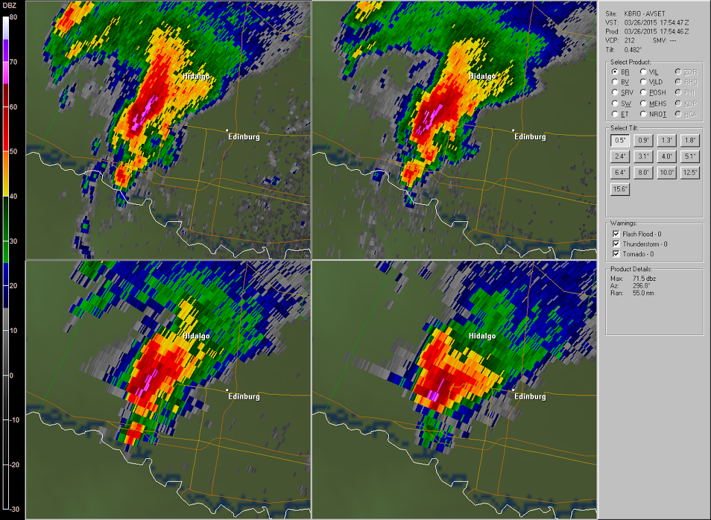 Four panel reflectivity image from Brownsville Doppler Radar. Areas in pink indicate values above 65 dbZ; purple, above 70 dbZ. A small area of 71 dbZ reflectivity at 25,000 feet is indicated in the lower right image, a clear indication of large hail (freezing level was around 13,000 feet)! Pattern Matters 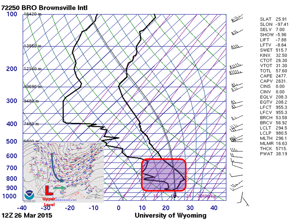 7 AM Atmospheric sounding from Brownsville, with unstable layer conducive to rapid ascent (lift) shown above a fairly strong inversion. That lift would be provided by the approach of an upper level disturbance (red L and green arrow) from west Texas and a deepening full latitude trough and associated surface cold front (blue arrow). |
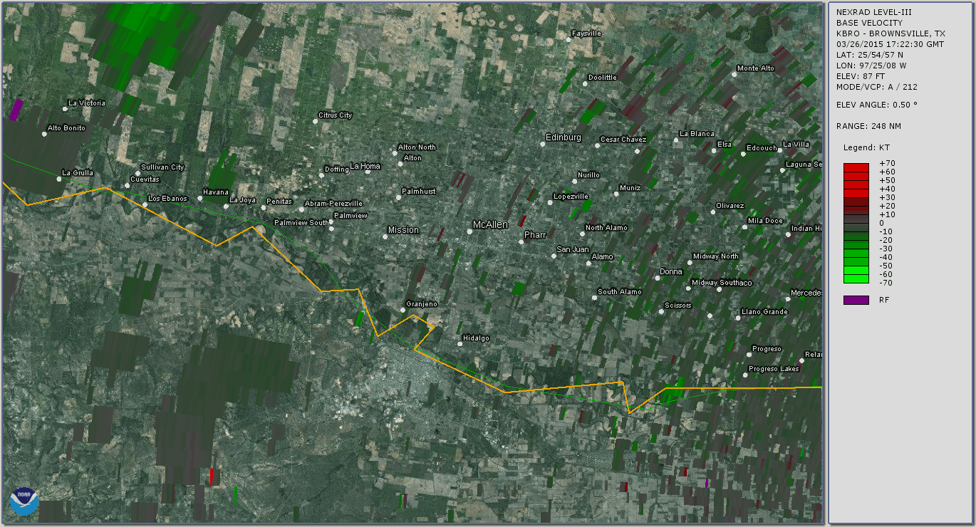 Loop of base velocity from 1222 through 124 PM March 26th, for single severe thunderstorm that tracked across western and central Hidalgo County, Texas. Frames with bright green color correlated to local damage to trees, power lines, and at least one home in the Citrus City and North Mission/Alton area. |
|
                       PRELIMINARY LOCAL STORM REPORT...SUMMARY
NATIONAL WEATHER SERVICE BROWNSVILLE TX
835 PM CDT THU MAR 26 2015

..TIME...   ...EVENT...      ...CITY LOCATION...     ...LAT.LON...
..DATE...   ....MAG....      ..COUNTY LOCATION..ST.. ...SOURCE....
            ..REMARKS..

0100 PM     HAIL             ALTON                   26.29N  98.31W
03/26/2015  E1.75 INCH       HIDALGO            TX   PUBLIC

            GOLF BALL SIZE HAIL REPORTED NEAR THE INTERSECTION OF
            HWY 107 AND STUART RD.

0103 PM     HAIL             MISSION                 26.21N  98.32W
03/26/2015  E0.88 INCH       HIDALGO            TX   BROADCAST MEDIA

            NICKEL SIZE HAIL REPORTED ON LA HOMA ROAD IN MISSION.

0105 PM     HAIL             ALTON                   26.29N  98.31W
03/26/2015  E1.00 INCH       HIDALGO            TX   PUBLIC

            QUARTER SIZE HAIL WAS REPORTED VIA SOCIAL MEDIA NEAR
            ALTON.

0110 PM     HAIL             MISSION                 26.21N  98.32W
03/26/2015  E1.50 INCH       HIDALGO            TX   PUBLIC

            QUARTER TO PING PONG BALL SIZE HAIL REPORTED NEAR THE
            INTERSECTION OF 3 MILE LINE AND STUART.

0115 PM     HAIL             2 NE MCALLEN            26.24N  98.22W
03/26/2015  E1.00 INCH       HIDALGO            TX   PUBLIC

            QUARTER SIZE HAIL REPORTED AT THE INTERSECTION OF
            NOLANA AND 23RD IN NORTH MCALLEN.

0115 PM     HAIL             STEWART PLACE COLONIA   26.22N  98.30W
03/26/2015  E1.25 INCH       HIDALGO            TX   PUBLIC

            HALF DOLLAR SIZE HAIL WAS REPORTED IN MISSION.

0120 PM     HAIL             1 NW PALMHURST          26.27N  98.33W
03/26/2015  E1.50 INCH       HIDALGO            TX   PUBLIC

            REPORT OF HALF DOLLAR TO PINGPONG BALL SIZE HAIL VIA
            SOCIAL MEDIA NEAR PALMHURST. TIME ESTIMATED FROM RADAR.

0122 PM     HAIL             1 ESE THOMAS ORTEGA COL 26.26N  98.25W
03/26/2015  E1.75 INCH       HIDALGO            TX   PUBLIC

            GOLF BALL SIZE HAIL WAS REPORTED AT THE INTERSECTION OF
            NORTH WARE ROAD AND LARK STREET...3 MILES NORTHWEST OF
            MCALLEN.

0124 PM     HAIL             1 S PALMHURST           26.24N  98.32W
03/26/2015  M1.25 INCH       HIDALGO            TX   PUBLIC

            HALF DOLLAR SIZE HAIL REPORTED SOUTH OF PALMHURST VIA
            SOCIAL MEDIA. TIME ESTIMATED FROM RADAR.

0130 PM     HAIL             1 SW FRANCIS ADDITION C 26.18N  98.22W
03/26/2015  E1.00 INCH       HIDALGO            TX   PUBLIC

            QUARTER SIZE HAIL WAS REPORTED AT THE INTERSECTION OF
            2ND STREET AND SAVANNAH ON THE SOUTH SIDE OF MCALLEN.
|
|


 Follow us on YouTube