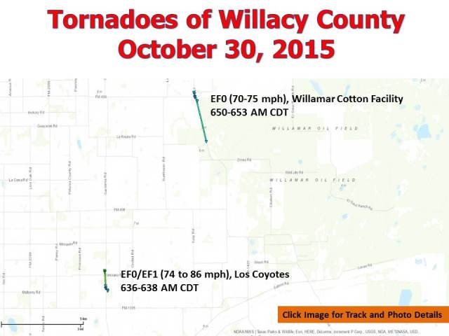
 Map of pair of short, small tornadoes in Willacy County early on October 30th. Click to view the point–by–point details, as well as photos taken by the NWS/Willacy County Emergency Management Survey Team in Google Earth. Need Google Earth? Click here. |
|
| October Surprise: Small Tornadoes Join the Willacy Flood Party Local Damage Precedes Another Round of Flooding Rains Oct. 30, 2015 |
|
|
A wave of upper level energy, arriving well ahead of a vigorous trough of surface and high level low pressure, acted on a very unstable airmass that was also conducive to producing rotating thunderstorms during the pre–dawn hours of October 30th to produce a "mini–supercell" thunderstorm in northern Cameron County, which raced northward through Willacy and into Kenedy County. The thunderstorm, which stood on its own, was able to take advantage of the atmospheric winds and spin up several rotating "couplets" (inbound and outbound wind in generally a circular shape, spinning counterclockwise) on its journey. One couplet spawned a brief tornado around Los Coyotes just after 630 AM, which moved to the north–northwest and quickly dissipated before reaching Raymondville. As the first couplet weakened, a second formed to its east south of Willamar, and soon spawned another tornado at a Cotton producing facility in Willamar. The tornado lifted; whether it touched down farther north in Willacy and Kenedy is unknown, as flooded fields eliminated any access to unpopulated areas north of San Perlita. The mini–supercell would be followed by yet another band of torrential rains for central Willacy County, with between 2 and 4+ inches falling on areas already underwater or just beginning to recover from up to 14 inches of rain during the prior seven days. These rains would re–flood San Perlita by early afternoon. The following is a preliminary list of talking points from the October 30th tornadoes in Willacy County.
 Screenshot from Davis Instruments Vantage Pro 2 Weather Station, courtesy of a local family. Click for larger image, but note the sharp wind shift from southeast to north, the gust to 86 mph, and a brief pressure drop as a small tornado raced across the property and lifted, then destroyed, a barn. |
|
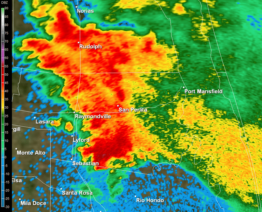 Base reflectivity, 0.5°, for around 630 to 715 AM October 30, 2015, in Willacy County. Note the two distinct "hook" echoes. The first, early in the loop, crossed Los Coyotes east of Lyford then dissipated southeast of Raymondville. The second formed near Willamar and quickly moved north through San Perlita and into Kenedy County through the top of the 7 AM hour. |
 Base velocity, 0.5°, for around 630 to 715 AM October 30, 2015, in Willacy County. Note the two distinct rotating couplets. The first, early in the loop, crossed Los Coyotes east of Lyford then dissipated southeast of Raymondville. The second formed near Willamar and quickly moved north through San Perlita and into Kenedy County through the top of the 7 AM hour. The couplet appeared to strengthen while moving toward the Kenedy County line, matching a well formed "hook" in the reflectivity signature; inability for the survey team to access flooded fields made it impossible to find further touch downs. |


 Follow us on YouTube