   |
|
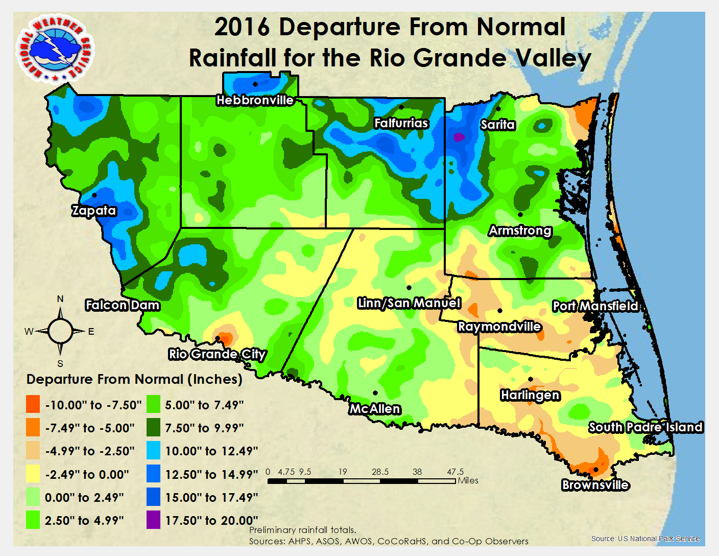 2016 Rio Grande Valley Rainfall Departure from 1981-2010 Average (inches). |
 2016 Rio Grande Valley Rainfall Percent of 1981-2010 Average. |
| The Heat Was On! 2016 Brings Record Warmth to Valley Year in Review: Endless Summer Dominant Just Enough Rainfall to Keep Big Drought At Bay |
|
|
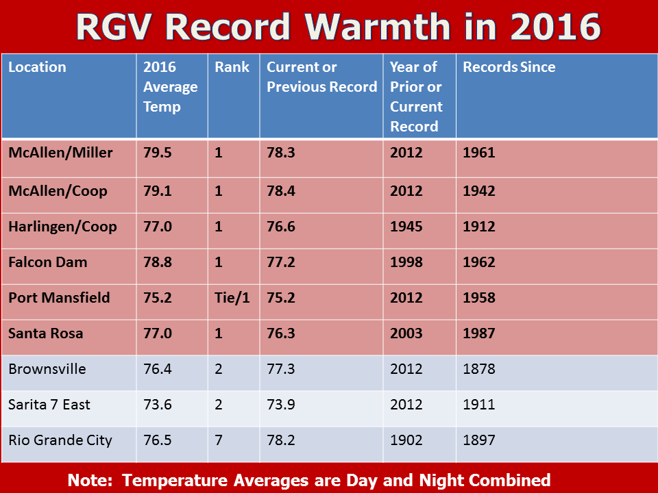
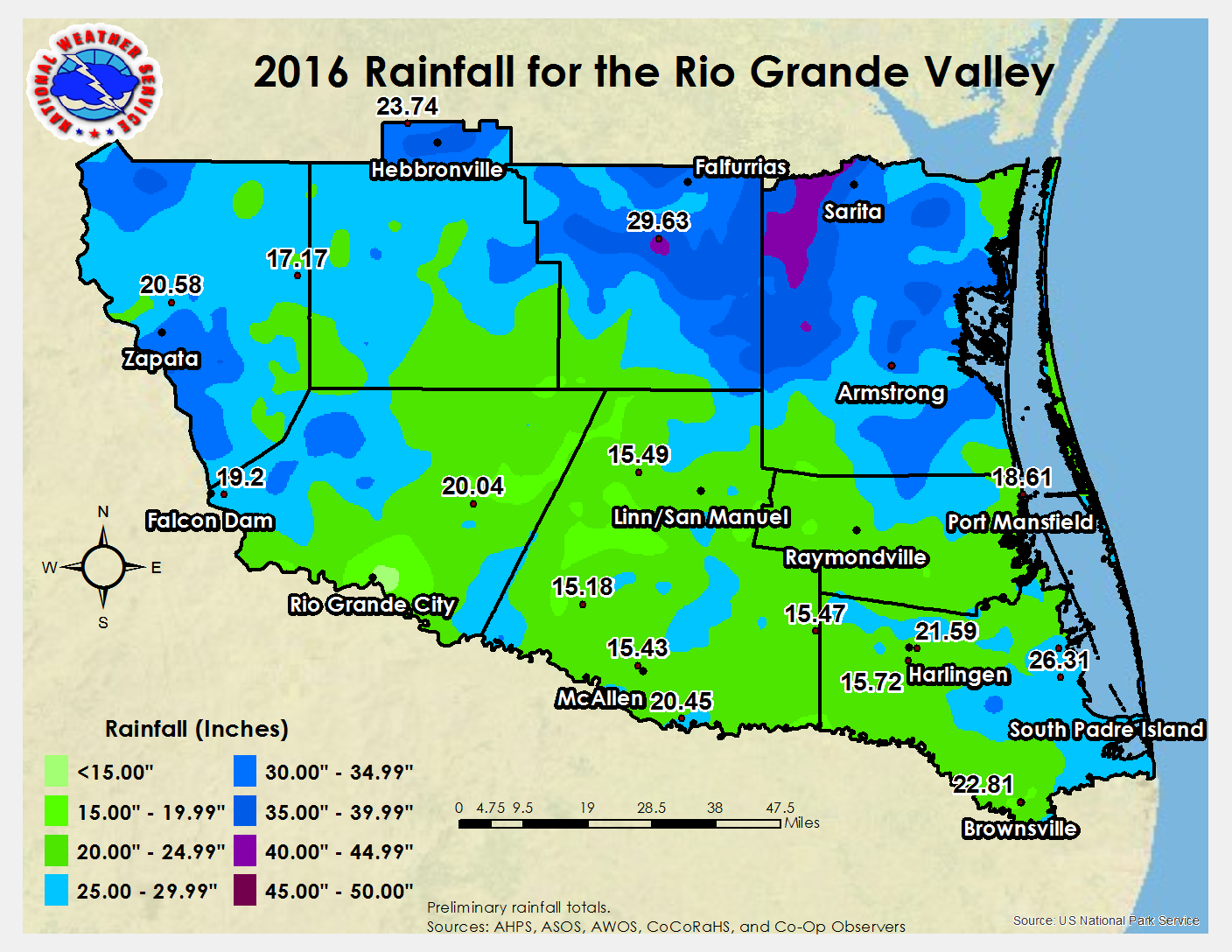
In Brief While rainfall waned in comparison to 2015, enough fell at periodic intervals to hold drought conditions mainly to abnormally dry to moderate, with just a few small windows and areas of severe drought in the Lower Valley following prolonged, and record, hot and dry weather from July through October. Annual rainfall dipped markedly from 2015, with totals in the agricultural-rich Lower Valley running around 75% of average (15 to 22 inches vs. 20 to 27 inches). Ranchlands north and west of the Valley did much better, more good news overall for cattle and other livestock. The King Ranch (eastern Brooks and Kenedy County) hit the relative jackpot with more than 150% of average rainfall, and Zapata County broke into the "black" with big rains in August, September, and December to push some areas to nearly 200% of average. Irrigation water remained a minor concern; in fact, the back-and-forth nature of rainfall between winter (dry), spring (generally wet), and summer (dry and hot) brought a bumper crop of cotton from Valley growers. Texas reservoir levels remained at high capacity across the eastern half of the state. Unfortunately, Falcon International Reservoir ended the year just above one-third capacity (Texas share), a result of the modest rainfall and the above average and prolonged evaporation setup by the record heat. Amistad (near Del Rio), fed by multiple U.S. and Mexican sources where prior levels combined with enough rainfall to keep percentages (84% at year's end) at their highest levels since 2010/2011, post-Hurricane Alex. For the year, preliminary temperatures at the three primary Valley locations were as follows:
Continue reading for a capsule of the many weather stories through 2016. Links are provided to take you to the full details of each event. |
|
| January to March: Cold Start, Mild the Rest of Way | |
|
For a third consecutive year, cold weather shocked the system at the start of the New Year, after a mild December 2015. Unlike the first eleven days of 2015, temperatures rebounded above average from the 6th through 9th. Thereafter, temperatures rode the fairly typical Valley "roller coaster" for the month, and January would end up being at or slightly below average for the Valley – the only such month of the calendar year. The close of winter 2016 (January-February) completely flipped the expected forecast for cooler and wetter weather; the <10 percent probability for below average rainfall was exactly how the entire season (Dec. 2015 through Feb. 2016) closed. Fronts came through dry rather than wet; one such front – a dryline event, blew through the Valley on January 16th with gusty and damaging wind. , on Cold and occasionally wet weather brought some of the coldest measured and "feels–like" temperatures on record for the first eleven days of January. The chill would quickly fade by mid month, and early spring–like weather would close January, including several "Chamber of Commerce" days just after the Martin Luther King Jr. Holiday. A brief summary of January’s transition is found here. February was non–descript, with nary a drop of rain ensuring the winter ended below average. The same pattern that brought dry weather also brought an early spring, as mid month temperatures surged into the 80s and 90s each afternoon. Month's end brought a return to slightly below average but still pleasant temperatures, but the month ended between 1 and 4°F above the 1981-2010 average. The lack of rainfall and warm temperatures brought the return of abnormally dry soil conditions to parts of the Upper Valley by month's end. The warm story rolled along into March, but after a nearly six week period without any appreciable rainfall, an unusually southward moving upper level low pressure area (which produced notable snowfall just north of Mexico City) dropped welcome 1 to 4 inches of rainfall between March 8 and 11 which killed off the abnormally dry areas and fed thirsty soils the necessary water to assist the spring growth spurts of area crops. Warm to hot conditions which preceded the system returned quickly after it departed, with 90s returning to the interior RGV through St. Patrick's Day. A brief cooldown that followed wasn't enough to moderate temperatures downward, and monthly averages were some 3 to 6°F above the 1981-2010 values and landed all Valley locations in the top 20 warmest all-time. |
|
| April to June: The Rain (and Lightning) Men Cometh...Again | |
|
Though not as intense and prolonged as the Spring Super Soaker of 2015, the late spring and early summer of 2016 had its share of active weather, including flooding rains, frequent lightning, and scattered wind damage. The quiet of January-March gave way to much more noise come April. The first big hit occurred late on April 18th into early April 19th when a vigorous upper level low pressure system over the Rockies and deep tropical flow southeast of the system – a system that produced 20 inches of rainfall and life threatening flooding in Houston a day earlier, set off southwest moving outflows that ultimately create thunderstorm clusters across the Upper and Lower Valley. Welcome rainfall east and west was accompanied by damaging winds and frequent to locally excessive lightning, as well as some hail. A week later, the rear of a departing disturbance set off a supercell thunderstorm that dipped through the King Ranch, dropping Golfball sized hail in Kenedy and northern Willacy County on April 24th. Once again, the month was well above average despite the improved rainfall - though the rainfall was selective and bypassed the highly populated McAllen metro region. The Valley's severe weather season tends to peak in May, and 2016 did not disappoint. Though the volume of rain and flood events was less than in 2015, two intense windstorms made the month memorable for the highly populated McAllen/Mission/Pharr/Edinburg area. A favorable upper level pattern, with multiple disturbances cutting through the edge of a subtropical ridge, provided the necessary lift to pump rich tropical moisture high into the still-cold atmosphere and bring a week of unsettled and locally hazardous weather from May 14th through 20th. On May 14th, a pulse severe storm damaged nearly three dozen colonia homes in San Carlos (near Edinburg); heavy rains from old boundaries on the 15th produced pockets of nuisance flooding in portions of the Valley but lined up for significant flooding across the Coastal Bend. Two more rounds of rain, lightning, and hail producing storms surged across the mainly rural ranchlands on the 17th and 18th, and a stationary thunderstorm along the river between the City of Hidalgo and Mission dropped an estimated 6 inches in open land near Granjeno. The most memorable event of the year occurred two weeks later, when a pre-midnight downburst dropped 85 to 95 mph damaging winds near the Rio Grande south of Mission. 150 buildings sustained damage, including nearly all uninhabited Winter Texan residences in the Chimney Park mobile home park, a recently built community recreational facility and shelter in Granjeno, and part of the roof at the State Farm Arena in the City of Hidalgo. In all, tens of millions in damage to buildings, trees, and utilities occurred and allowed Hidalgo County to successfully apply for federal emergency assistance. Spring (March-May) was a junior version of the record soaker of 2015. The lesser but welcome spring rainfall – which still ended up being 200 to 300 percent of average for much of the Valley – occurring at just the perfect intervals, was the thirst-slaking need for Valley crop growth and would set the stage for profitable returns of most crops by the summer harvest, when drier and hotter weather arrived at the right time. June began where May left off, with an active pattern for most of the Valley population producing daily rainfall through the 5th. Rainfall on Saturday, June 4th, spawned by a series of thunderstorm clusters along a stationary front, dropped 1 to 3 inches of rain in the Lower Valley which set the month near average despite just one more period of isolated rains between the 24th and 28th. The early June rains helped keep temperatures 3 to 5°F below the typically hot average, before things heated up again by mid month. The abundant soil moisture resulting from the April through early June rains kept temperatures in check for most of the month, and for the first time since January, monthly values ended up close to the 1981-2010 average (day night combined)in the lower 80s. The spigot, however, was about to shut off by month's end, as "La Canícula's "Dog Days" arrived in force to close out the first half of 2016. To Page 2 |
|


 Follow us on YouTube