National Weather Service United States Department of Commerce


Visible satellite of atmospheric cyclone in south Texas, early on March 11, 2016
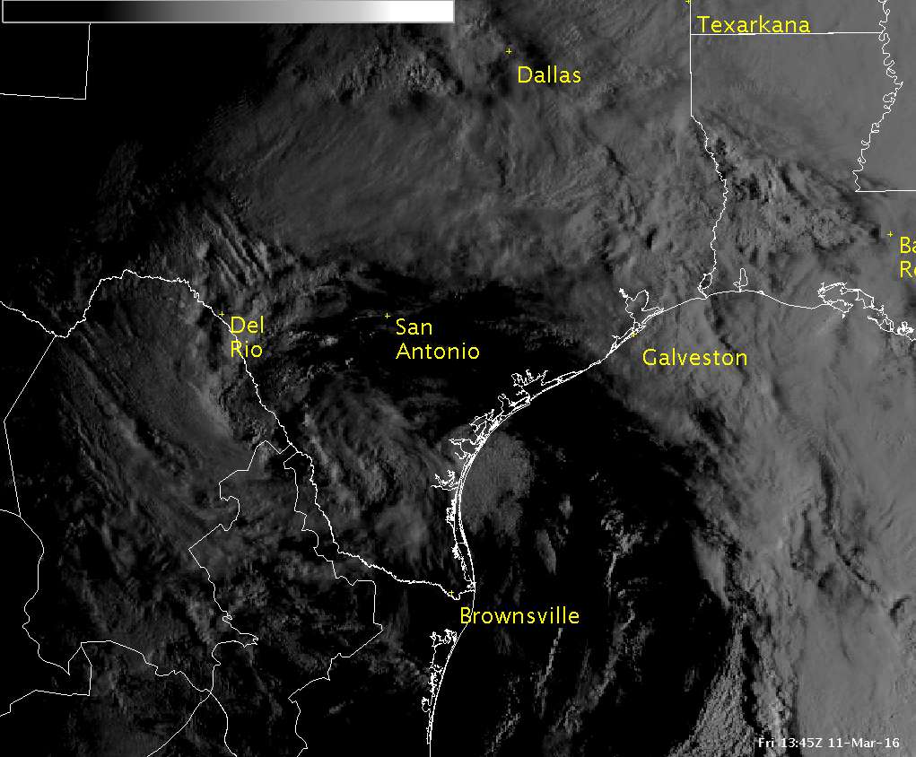
Visible Satellite loop from the morning of March 11, 2016, of atmospheric cyclone moving across Deep South Texas
Accumulated rainfall, March 8th through 11th 2016 for the Rio Grande Valley of Texas
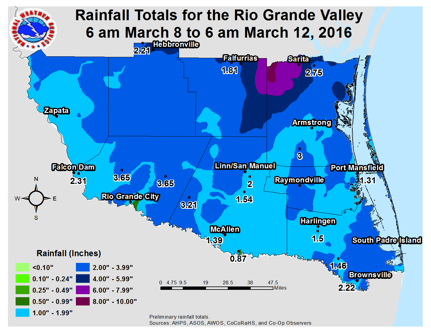
Accumulated rainfall for March 8th through 11th 2016 for the Rio Grande Valley (click for full size)
Flash Drought, Wiped Out!
Rainy, Unsettled Weather March 8–11, 2016 Settles the Dry Score
 

After a winter when the El Niño wet and cool forecast failed to materialize, spring, albeit briefly, had other ideas. A single atmospheric cyclone, with origins in the East–Central Pacific Ocean north of the more typical subtropical zone where El Niño–borne cyclones form, took a sharp dive into Mexico – Central Mexico on March 9th and 10th, before curling across the Valley on March 11th and dissipating into the strong westerly flow in northeast Texas on the 12th. The deep, non–tropical cyclone, which for some became known as the "Mayan Express" due to its peak intensity in Mexico, produced widespread and in some cases record flooding rains across Louisiana and east Texas and snow as far south as Zacatecas State in central Mexico at 7 thousand foot elevation! There were at least six related fatalities in east Texas and Louisiana directly or indirectly from the floods as of mid March. For the Rio Grande Valley, the system produce drought–relieving rains, but did create a few headaches along the way.

U.S. Animation of 500 mb pattern from March 6 through 13, 2016
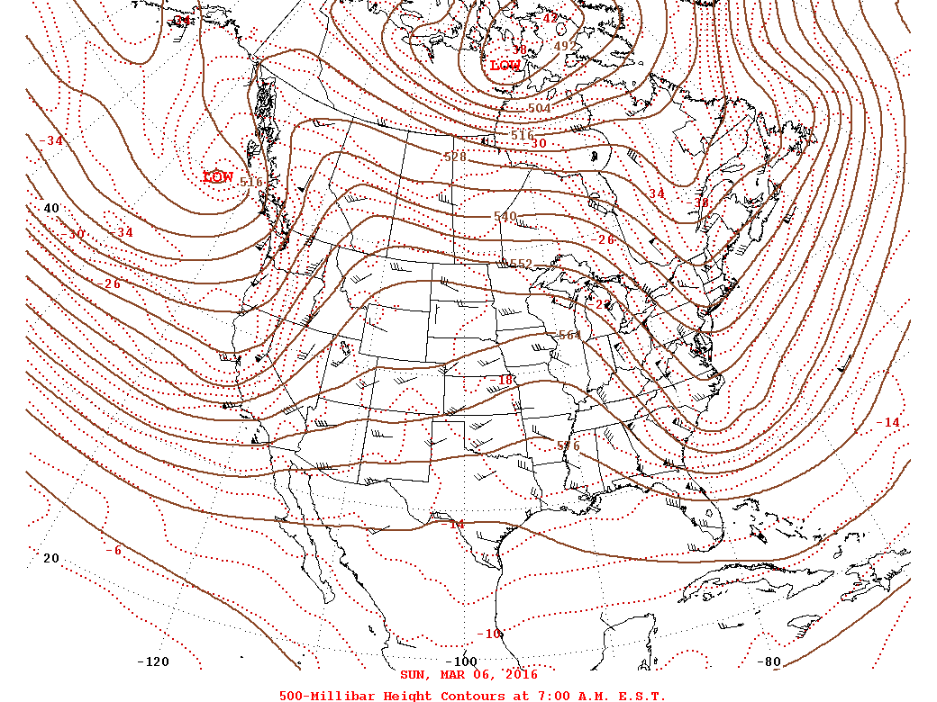
Atmospheric non–tropical cyclone evolution at around 18,000 feet (500 mb pressure) from March 6 through 13, 2016. Note the originating location over the eastern Pacific, well north of the subtropics where typical El Niño disturbances form. The southward extent of the system was very rare, but similar systems have occurred in other winters and springs, El Niño or not.
 

Rainfall
The rains came in fits and starts, not too surprising given the type of system – "closed off" non–tropical cyclone prior to arrival in the Valley. [Note that open systems tend to maintain energy release on the east and poleward side in the northern hemisphere, which can produce copious rainfall in more organized fashion. Such was the case from Houston through Shreveport and Lake Charles, Louisiana.] Initial, welcome rains dropped an inch or more across Jim Hogg, Starr, and Zapata County; the cold temperatures above the warm surface helped with hail formation in stronger cells between 8 PM and 2 AM on the 8th/9th. Across the Valley, the atmosphere was effectively "capped" – which meant surface warmth and humidity could not penetrate even warmer air above the inversion. Rain was walled off from developing across the populated Rio Grande Valley while the atmosphere was at its most unstable above the cap. This would change rapidly just before daybreak, as the "cap" weakened. A band of thunderstorms developed rapidly across central and western Hidalgo County, and would ultimately drop up to an estimated 4 to 8 inches of rain across the rural King Ranch of Kenedy County and along the Coastal Bend from Kingsville to Corpus Christi by mid morning. In Hidalgo County, the band generally dropped between 1 and 3 inches of rain (highest north), which was mixed with hail at times (below).

Radar loop of 0.5 degree reflectivity across Hidalgo County between 5 AM and 717 AM CST March 9, 2016
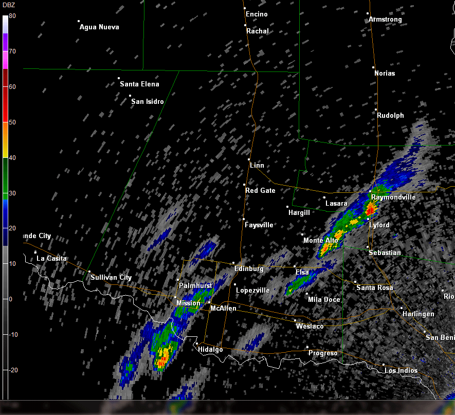
Radar loop of 0.5° reflectivity for rapid development of a band of thunderstorms between 5 and 717 AM CST, mainly across Hidalgo County Texas. Pixels in pink or purple likely indicated sufficient hail to reach the ground.
 

Rainfall, Continued
As the disturbance slid toward central Mexico on the 9th, a spoke of energy rotated on its east side and regenerated bands of thunderstorms with locally heavy rainfall, this time across the Lower Valley, during the afternoon and evening of the 9th. Additional light to moderate rains built back across the mid Valley; in all, for the period from sunrise March 9th through sunrise March 10th, 2 to 3 inches fell east of Brownsville, with 1 to 2 inches elswhere along U.S. 77/IH 69E. On March 10th, with the core of the disturbance edging northward toward Zapata County, afternoon sunshine destabilized the atmosphere substantially across the Upper Valley and along the lee of the Sierra Madre through Tamaulipas and Nuevo Leon. Bands of thunderstorms broke out prior to sunset and would continue a few hours after, peaking along the river east of Rio Grande City in the colonias of La Casita, Alto Bonito, and La Victoria, where flash flooding shut down U.S. 83 and reached into a few homes. In total, the entire region received one to four times the March monthly average in less than 48 hours. The core of the cyclone passed early on the 11th, taking the rain with it – but not before dumping enough in all areas to eliminate, for the time being, dry to moderate drought conditions.

Radar loop of 0.5 degree velocity across Hidalgo County between 618 AM and 717 AM CST March 9, 2016
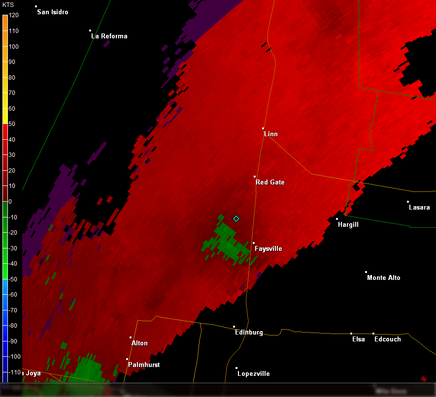
Radar loop of 0.5° velocity for a band of thunderstorms between 618 and 717 AM CST, March 9th 2016, centered near Linn, Texas.
Photo of newly leafed mesquite tree uprooted along FM 1017 just west of Linn, Texas, on March 9, 2016
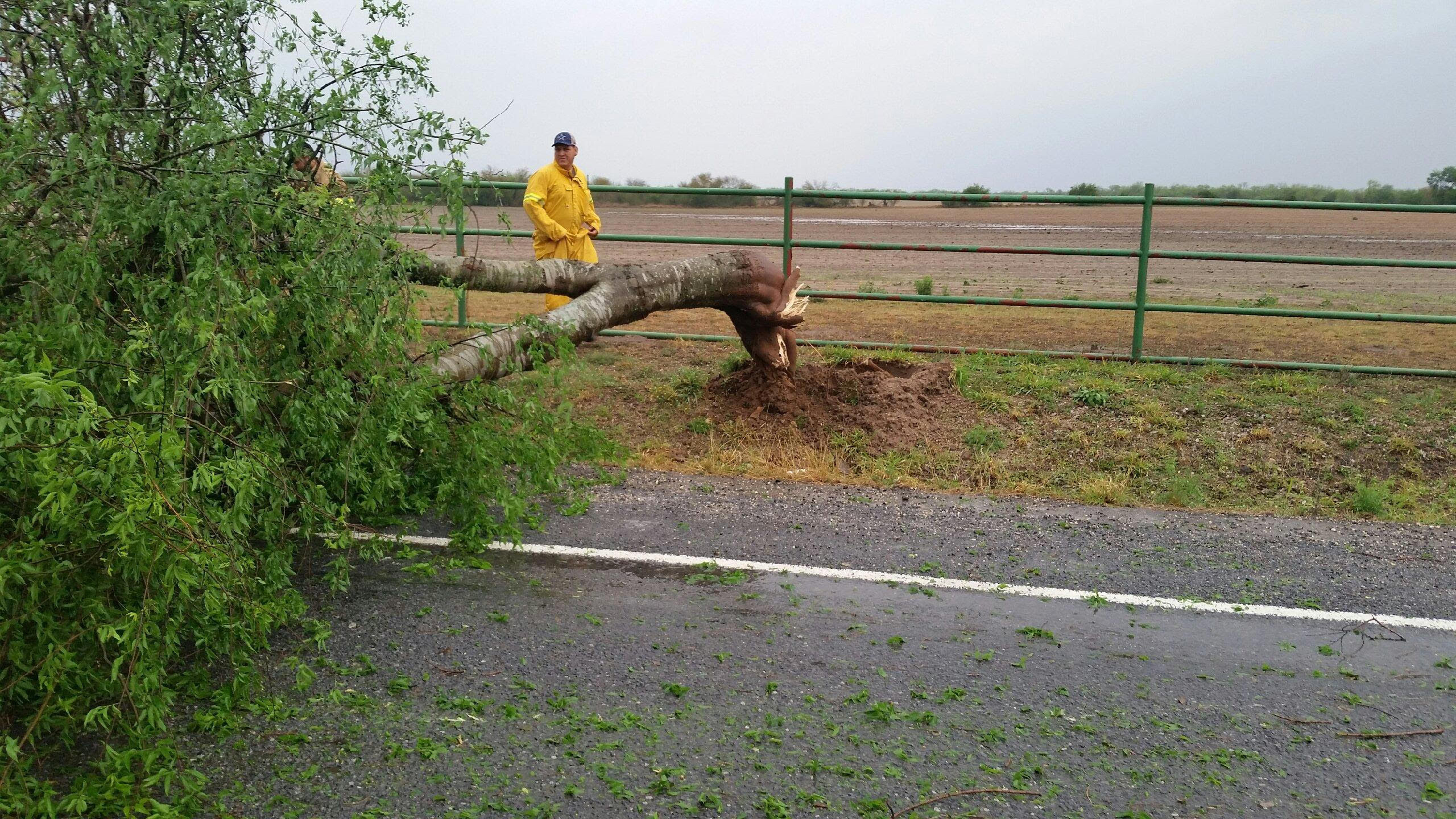
Photo of uprooted, newly–leafed mesquite tree along FM 1017 just west of Linn, Texas, early on March 9, 2016
 

Damaging Wind and Hail
As the "cap" eroded just before daybreak on March 9th across the Valley, southerly winds at 2 thousand feet were as high as 71 mph (Brownsville) at just after 5 AM CST. When thunderstorms developed rapidly between 5 and 530 AM, they were able to tap into some of these winds and pull them toward the surface. In addition, very cold air above the weakening cap supported hail formation. Fortunately, storm motion – also driven by those speedy low level winds – was fast enough to keep rotating supercell thunderstorms from developing; hence the more linear look to the cells as they cruised to the north–northeast.

Still, some cells along the line were able to sustain enough updraft to produce hail, which fell briefly in spots across the McAllen/Edinburg area, with a few reports of half inch to quarter sized hail just before 6 AM. Sometime between 630 and 7 AM, one cell was able to drop an estimated 65 mph wind gust on the small town of Linn, where a power pole fell and several mesquite trees were uprooted along FM 1017 just west of the U.S. 281/IH 69C expressway. The cells would further consolidate into a line west of Linn and extend toward La Joya before lifting out by 9 AM.

Preliminary Rainfall March 8th through 11th, 2016
Location
County
Source
Rainfall
Rio Grande City 17.7 NE
Starr
CoCoRaHS
3.65
Rio Grande City 13.8 NNW
Starr
CoCoRaHS
3.65
Brownsville 12.6 E
Cameron
CoCoRaHS
3.45
La Joya 11.1 N
Hidalgo
CoCoRaHS
3.21
Raymondville
Willacy
Cooperative
3.00
Linn 8.4 WNW
Hidalgo
CoCoRaHS
2.78
Sarita 7 E
Kenedy
Cooperative
2.75
Bayview/Cameron Co. Airport
Cameron
ASOS
2.57
Falfurrias 0.4 WNW
Brooks
CoCoRaHS
2.47
Raymondville 2.0 SSW
Willacy
CoCoRaHS
2.37
Falcon Lake
Starr
Mesowest/RAWS
2.31
Weslaco 2 E
HIdalgo
Cooperative
2.30
Hebbronville
Jim Hogg
Cooperative
2.23
Brownsville/SPI Airport
Cameron
ASOS
2.22
Hebbronville Airport
Jim Hogg
Mesowest/RAWS
2.21
Laguna Atascosa NWR
Cameron
Mesowest/RAWS
2.13
Santa Rosa
Cameron
Cooperative
2.07
Falfurrias 6.2 E
Brooks
CoCoRaHS
2.02
San Manuel LRGV NWR
Hidalgo
Mesowest/RAWS
2.00
Brownsville 1.0 N
Cameron
CoCoRaHS
1.99
Falfurrias 8.9 SSW
Brooks
CoCoRaHS
1.94
Harlingen 4.4 W
Cameron
CoCoRaHS
1.79
Mission 3.9 WSW
Hidalgo
CoCoRaHS
1.79
San Benito 0.9 SSE
Cameron
CoCoRaHS
1.63
Armstrong 4 SE
Kenedy
Cooperative
1.62
Edinburg/Int'l Airport
Hidalgo
AWOS
1.54
Rio Hondo 9.4 NE
Cameron
CoCoRaHS
1.52
Harlingen
Cameron
Cooperative
1.50
Harlingen Valley Int'l Airport
Cameron
ASOS
1.49
Escobas
Zapata
Cooperative
1.46
McAllen
Hidalgo
Cooperative
1.39
Port Mansfield
Willacy
Cooperative
1.31
Los Fresnos 0.3 NE
Cameron
CoCoRaHS
1.26
ASOS=NWS Automated Surface Observing System
Cooperative=NWS Cooperative Observing Climate Network
CoCoRaHS=Community Collaborative Rain, Hail, and Snow Network
Mesowest/RAWS=University of Utah sponsored network, including Remote Automated Weather Station
AWOS=Automated Weather Observing System (Managed by FAA)