National Weather Service United States Department of Commerce


Damage to gable end roof in a colonia in San Carlos, TX, from the late afternoon of May 14, 2016, around 550 PM
Damage to a gable end of a roof at a home in a colonia in San Carlos, east of Edinburg, TX. Downburst winds 60 to 65 mph took down the roof
Two images of base velocity at 0.5 degrees, clearly showing downburst winds surging from the west side of Hargill/Faysville area southeast into the San Carlos area, between 535 and 555 PM, May 14th, 2016
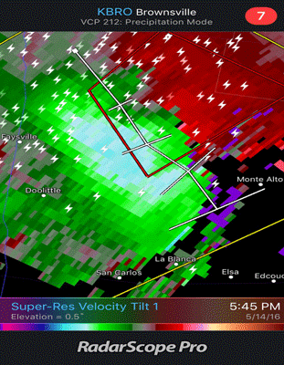
Two looped screen shots of radar base velocity at 0.5° elevation, or about 4000 feet above ground, that indicated winds of 60+ mph moving quickly south from west of Hargill to San Carlos in Hidalgo County, TX, between 535 and 555 PM May 14th, 2016

A Week of Hazardous Weather, May 14 to 20, 2016
RGV, Ranchlands Face Big Hail, Big Wind, and some Big Rain
 
Damage points, photos, and descriptions from the Hargill/Faysville area to San Carlos in Hidalgo County, Texas, following the May 14th Downburst
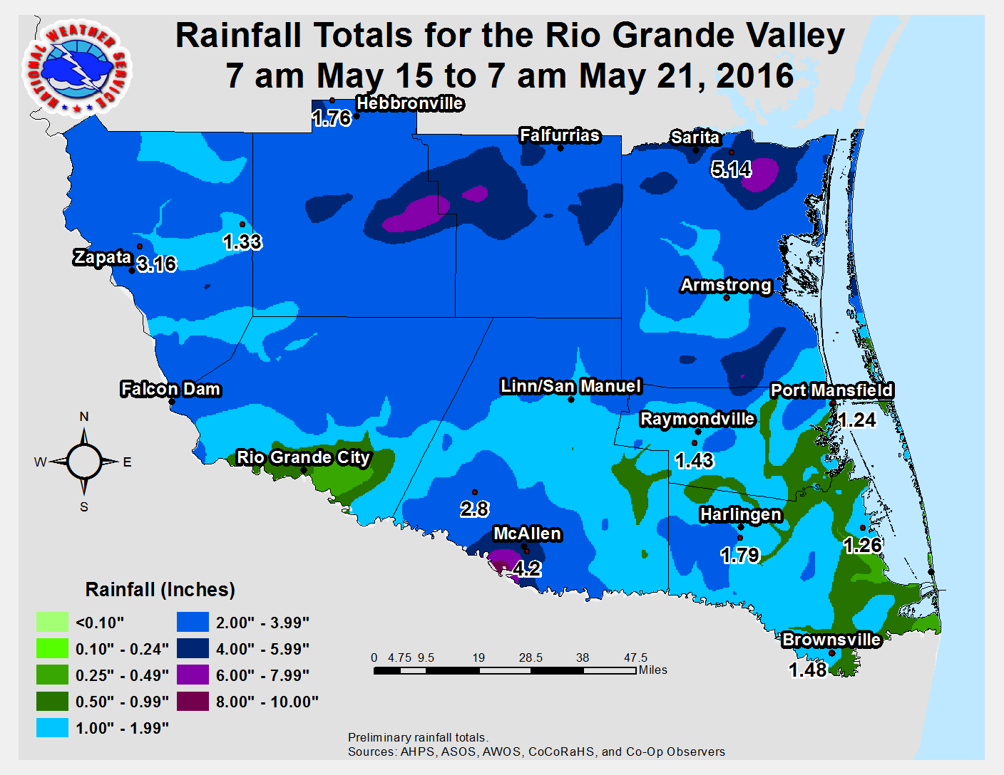
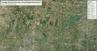
Short survey of structure, tree, and power line damage from west of Hargill to San Carlos, TX, from May 14, 2016 downburst. Click to download the data in Google Earth. Need Google Earth? Click here
 

After a quiet start to May, which featured a refreshing front on May 1st that brought drier days and pleasant nights right into the Mother’s Day Weekend, the pattern shifted back to a trough centered over the southwest U.S. (below) that ejected ripples of energy eastward, beginning by mid month. Starting on the second weekend of May and finally taking a break by May 21st, these ripples enhanced southerly flow and pulled tropical moisture into Texas, which was lifted into thunderstorms that produced significant rainfall, hailstorms, and damaging wind across the Rio Grande Valley, South Texas Brush Country, and Coastal Bend.

May 14 through 18: Mixed Bag, Favoring Wind and Hail
The first entreé into hazardous weather was on Saturday, May 14th. On what appeared ahead of time to be a benign (though hot and humid) start to the weekend – statistical guidance advertised less than 10 percent rain chances – enough atmospheric energy combined with differential heating boundaries to kick off thunderstorm clusters across the ranchlands during the early afternoon. Boundaries from these cells would set up new development south and west, and eventually most of the region received between 0.75 and more than 4 inches of rainfall! One cell in particular become bow–shaped as it headed through northern and central Hidalgo County, and would eventually drop a 10 mile long, 2 mile wide (varying) downburst of 60 to 65 mph wind from 4 miles west of Hargill to 5 miles east of Edinburg, between 535 and 555 PM. Damage began along Farm to Market Road 490 west of Hargill, where a string of three power poles were blown down, as well as several 1 to 3 inch diameter mesquite limbs. Crops in a nearby grain field were also blown at an angle from northwest to southeast. Damage was more notable in colonias in the San Carlos area east of Edinburg, where one poorly anchored roof and one carport were lifted along Farm to Market 2182, and partial roof damage was noted (above) to a single family home and multiple mobile (trailer) homes lost parts of their tin roofs. In all, according to county officials and additional surveys, at least three dozen homes sustained structural damage in the area.

On Sunday, May 15th, leftover boundaries from the Saturday storms acted on plenty of residual heat and humidity to kick off scattered late morning through late afternoon activity, which favored the Lower and Mid Valley and extended through the King Ranch. The additional rain exacerbated nuisance flooding in the colonias that received nearly 3 inches the prior day, and peaked with more than 4 inches that caused urban flooding around Harlingen during the mid afternoon. The biggest rains that afternoon and overnight struck the Coastal Bend, where more than a foot fell and flooding was widespread and property–damaging.

Mean 500 mb pattern across the southwest U.S. through the Gulf States, May 14 to 21, showing persistent southwest flow aloft pumping in deep tropical moisture underneath hazardous weather making disturbances
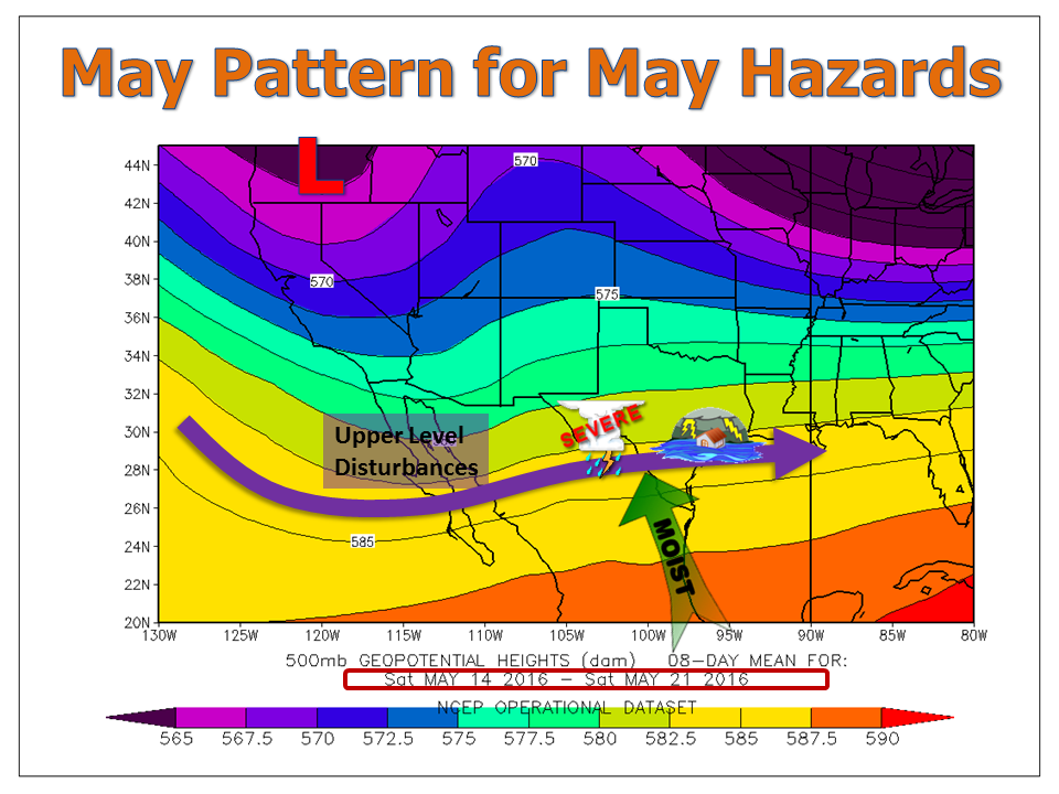
500 millibar (~18,000 feet) steering pattern for May 14 through 21, 2016. Upper level disturbances moving along the purple arrow helped lift a deep feed of moisture from the tropics into strong to severe thunderstorms across much of south Texas.
 

May 14 through 18: Mixed Bag, Favoring Wind and Hail (continued)
A brief respite on the 16th was quickly followed by an overnight hail and heavy rainfall event across the Rio Grande Plains and Upper Valley. Discrete hail storms across the South Texas Brush Country during the evening of the 17th would develop around and just after midnight in Starr County, where 1.75 to 2 inch diameter hail pelted El Sauz and other locations north of Rio Grande City. A video from north of Rio Grande City clearly showed the event. The convective system that evolved from the hail makers would later produce wind gusts in excess of 50 mph from Weslaco to Harlingen – outflows from the system moving through Tamaulipas before daybreak on the 18th. These winds would knock over lawn furniture, trash cans, etc. in the Lower and Mid Valley.

Typically, overnight storms "work over" the atmosphere and bring a quieter day to follow. Because the main system formed in Mexico, remaining boundaries and a oppressively warm, humid day combined with another weak disturbance to create a long track, mini–supercell storm that zipped across the Rio Grande Plains and rural ranchlands from Zapata through Kenedy County during the early and mid afternoon of the 18th. Though no reports of large hail and damaging winds were received, the storm did produce frequent to excessive lightning along its path and may well have produced some hail and wind before fading into the Gulf.

May 20: Slow Moving Thunderstorm Floods South Mission
Just when it seemed as if the week of weather had wound down, a nearly stationary thunderstorm developed right on the Rio Grande between south Mission and the City of Hidalgo during the mid evening. Rainfall between 2 and 4 inches fell in portions of south McAllen, Hidalgo, and south Mission (including the Sharyland area), with reasonable radar estimates of over 6 inches in an unpopulated area west of Hidalgo and east of Granjeno along the river (below). Though life and property flash flooding was spared due to the rural and rain falling over the levee protected river, urban flooding was common in south McAllen and Mission, shown below.

Urban flooding across the south side of Mission
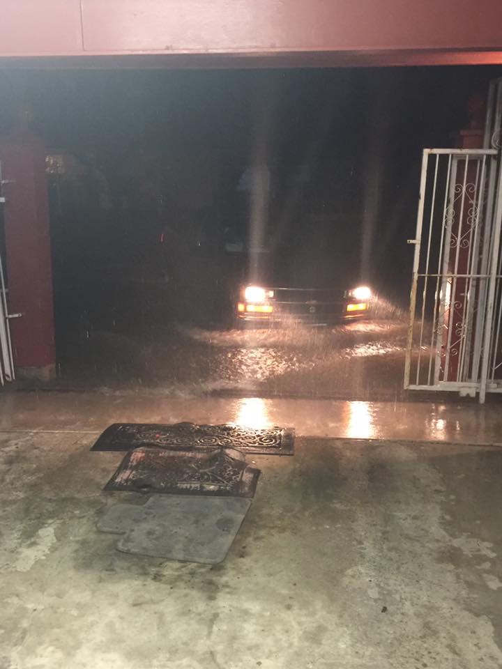
Photo from South Mission during evening of Friday, May 20th, showing urban type flooding. Courtesy of KRGV Channel 5 Facebook page, shared with NWS Brownsville/Rio Grande Valley’s Facebook page.

Advanced Hydrologic Prediction System bias corrected rainfall estimate from May 20, 2016, zoomed into Hidalgo County
Screenshot of Advanced Hydrologic Prediction System bias corrected rainfall estimate for May 20th, 2016, zoomed into Hidalgo County. Six inches was estimated over a rural area near the levee protected Rio Grande.


Rainfall map for May 14 through 20, 2016