 |
|
| Rip Current Forecasts and Information | |
|
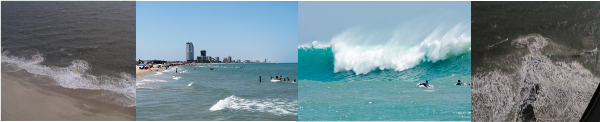
Rip current information can be found daily from local National Weather Service Offices that serve the Gulf and Atlantic Coast. Some offices, such as the National Weather Service Office in Miami, provide a graphical outlook for rip current risk each day, as well as the standard text hazardous weather outlook and surf zone forecast. NWS Brownsville/Rio Grande Valley provides daily text rip current information through the Beachcast (Click on the "Beachcast" tab below Top News of the Day), Surf Zone Forecasts, and Hazardous Weather Outlooks. This information is issued between 4 and 6 AM each morning, and updated as necessary through the day as conditions warrant. In addition to the links above, the Surf Zone Forecast and Hazardous Weather Outlook are available by listening to NOAA All Hazards Radio, broadcasting at 162.55 MHz from Brownsville and 162.40 MHz from Pharr, and 162.425 MHz from Rio Grande City* (*Hazardous weather outlooks may not include coastal information each day). Risk Factors The meteorological factor considered is wind waves. Generally, the stronger the winds along the Lower Texas coast, the higher the waves. Higher wind waves typically result in higher breaking waves at the coast. The astronomical factor considered is the moon phase. If there is a full or new moon, when the alignment of the sun, earth, and moon are in line, the tidal pull of the Sun combines with the tidal pull of the moon, resulting in an additional gravitational pull on the earth and higher tides at the coast. After weighing and combining all of these factors, the rip current risk is determined. These risks are categorized as Low, Moderate, or High, and designed for the Cameron County beaches from South Padre Island to Boca Chica, though they may be used for persons venturing north toward the Port Mansfield jetties and beyond.
The daily rip current risk is provided to the public in the surf zone forecast, mentioned earlier. The surf zone forecast also gives additional information about conditions that can be expected at the coast, including tide information, ultraviolet index, surf water temperature, ambient air temperature, weather conditions (rain or no rain), and wind speed and direction. Moderate or higher risk will be carried in the hazardous weather outlook, and starting in May, significant threats, either from risk alone or the combination of risk and expected crowds at the beach, will be provided in an experimental Rip Current Statement. |
|
| Return to Index | |


 Follow us on YouTube