Lake Effect Summary - January 29-30, 2014
|
|
|
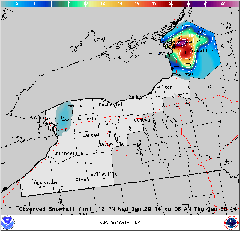
Maximum Snowfall: Lake Erie 1" (North Amherst); Lake Ontario 26.7" (Watertown) Duration: 18 hours +/- Prime feature: West-southwest flow over Lake Ontario, very little response off Lake Erie. Our 9th event of the winter season came on the heels of a long duration lake effect snow band that dropped several feet of snow east of Lake Ontario January 27th and 28th. A weak, multi banded lake effect snow structure continued across Jefferson County through the morning and early afternoon hours on Wednesday January 29th. An aligning 230 wind direction, combined with moisture deepening in a zone that promotes snowflake growth, allowed the lake effect snow to consolidate and intensify through the afternoon hours over the city of Watertown and points inland. By mid afternoon, a single band of snow was dropping several inches of snow per hour over Watertown. This band stayed nearly stationary over central and northern portions of Jefferson County, including the city of Watertown. It was not until the evening hours that the band of snow settled southward a little, with the upslope regions of the Tug Hill beginning to accumulate several inches of snow.
Backing winds during the overnight again shifted this band of snow back north over the city of Watertown, with snow ending over the Tug Hill. As wind shear increased and moisture decreased in the lower levels, the snow band began to weaken just before the morning rush hour on the 30th of January. This band of snow quickly fizzled, such that by dawn, there were just a few flurries flying over northern Jefferson County.
|


 Follow us on YouTube