Lake Effect Summary - February 6-7, 2014
|
|
|
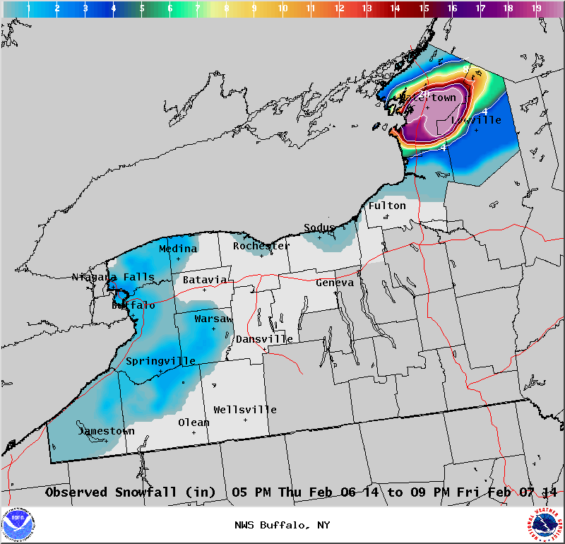
Maximum Snowfall: Lake Erie 1.4" (Colden); Lake Ontario 30" (Watertown) Duration: 18 hours +/- Prime feature: Northern extent of Lake Ontario band. Our 10th event of the winter season again focused lake effect snow to areas east of Lake Ontario. On Wednesday February 5th, a day prior to our lake effect event, a winter storm passed through the Ohio Valley and southern Mid Atlantic region, spreading nearly a foot of snow across the Eastern Great Lakes region. Behind this system, cold air expanded southward across Lake Ontario. An upper level low remained across eastern Canada through this event, with a shortwave trough extending southwestward from this low over the western Great Lakes. This allowed a southwest flow to continue across both eastern Great Lakes and lake effect snow formed off Lake Ontario during the early evening hours on Thursday, February 6th. Initially, there were two bands of lake effect snow, one over Watertown and inland towards Theresa and Philadelphia, and a second band forming well to the north over Canada and the Thousand Islands region. Winds through the boundary layer veered a little through the evening and both snow bands settled southward. By late evening a band of snow was over Watertown, and another band, more broadly structured, was oriented over the Tug Hill region. Temperatures at 850 hPa dropped down to around -20C Friday morning, and very little wind shear occurred through about five thousand feet. This allowed a singular, intense band of snow to continue through the night. The band of snow did touch southern portions of the Tug Hill overnight, but backing winds maintained the brunt of the band over the northern Tug Hill region and Watertown and central Jefferson County region. With the long fetch over the lake, the lake effect snowband became most intense late overnight with snowfall rates up to two inches per hour. Through the morning hours the band of snow created slick driving conditions over southern portions of Jefferson County and the northern Tug Hill. By lunchtime, winds had backed to a 240 degree flow ahead of a shortwave and brought the band of snow into the Watertown area. As the band shifted northward it started to become less intense, though the band still produced one inch of snow per hour. As wind shear increased with the passing shortwave aloft, the band of snow became diffuse and produced just light snow showers and flurries across the North County through the afternoon and evening hours. This event continued to pile up snow across central Jefferson County and the Tug Hill region. The greatest snowfall from this lake effect band fell over central Jefferson county, where 2 and a half feet of snow was recorded by the evening of February 7th in the Watertown area. This snow was in addition to the two to four feet of snow that fell over the 2 weeks leading up to this event, making clean-up all the more difficult.
|


 Follow us on YouTube