A large cluster of supercell thunderstorms impacted much of eastern Tennessee, southwest Virginia as well as the Carolinas
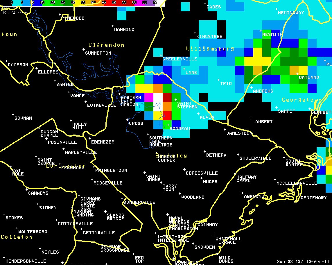
on Saturday, April 9, 2011. Numerous reports of large hail were relayed to the National Weather Service by the public, Skywarn spotters, and law enforcement agencies throughout the day. One especially intense thunderstorm moved across portions of northern Berkeley County, SC during the late evening hours dropping quarter to tennis ball size hail in communities such as Pineville, Saint Stephen and Bonneau. At 1120 pm EDT, a Skywarn spotter reported tennis ball size hail near the community of Russellville about 3 miles west-southwest of Saint Stephen. A peak wind gust of 64 mph was also observed by National Weather Service wind equipment on the Santee Dam along the eastern shore of Lake Marion.
Click any image for a larger version.

..TIME...   ...EVENT...      ...CITY LOCATION...     ...LAT.LON...
..DATE...   ....MAG....      ..COUNTY LOCATION..ST.. ...SOURCE....
            ..REMARKS..

1105 PM     TSTM WND GST     14 WNW SAINT STEPHEN    33.48N  80.15W
04/09/2011  M64 MPH          BERKELEY           SC   OFFICIAL NWS OBS

1112 PM     HAIL             5 WNW SAINT STEPHEN     33.43N  80.01W
04/09/2011  E1.75 INCH       BERKELEY           SC   LAW ENFORCEMENT

            QUARTER TO GOLFBALL SIZE HAIL REPORTED IN PINEVILLE.

1120 PM     HAIL             3 WSW SAINT STEPHEN     33.39N  79.97W
04/09/2011  M2.50 INCH       BERKELEY           SC   TRAINED SPOTTER

            GOLFBALL TO TENNIS BALL SIZE HAIL REPORTED NEAR
            RUSSELLVILLE.

1123 PM     HAIL             SAINT STEPHEN           33.40N  79.92W
04/09/2011  E0.88 INCH       BERKELEY           SC   TRAINED SPOTTER

1125 PM     TSTM WND DMG     SAINT STEPHEN           33.40N  79.92W
04/09/2011                   BERKELEY           SC   FIRE DEPT/RESCUE

            TREES DOWN BETWEEN BONNEAU AND SAINT STEPHEN.

1125 PM     HAIL             SAINT STEPHEN           33.40N  79.92W
04/09/2011  M1.75 INCH       BERKELEY           SC   FIRE DEPT/RESCUE

            FIRE DEPARTMENT PERSONNEL REPORTS GOLF BALL SIZE HAIL
            BETWEEN SAINT STEPHEN AND BONNEAU.

1125 PM     HAIL             BONNEAU                 33.31N  79.96W
04/09/2011  M1.25 INCH       BERKELEY           SC   PUBLIC

            QUARTER TO HALF DOLLAR SIZE HAIL REPORTED NEAR BONNEAU.

1128 PM     HAIL             4 ESE BONNEAU           33.27N  79.90W
04/09/2011  M1.75 INCH       BERKELEY           SC   PUBLIC

            GOLFBALL SIZE HAIL FELL FOR 10 TO 15 MINUTES IN THE
            MACEDONIA AREA.

1128 PM     HAIL             4 E BONNEAU             33.30N  79.90W
04/09/2011  M1.75 INCH       BERKELEY           SC   TRAINED SPOTTER

            GOLFBALL SIZE HAIL REPORTED BY SKYWARN SPOTTER. EAST OF
            BONNEAU.

1130 PM     HAIL             6 ESE BONNEAU           33.27N  79.87W
04/09/2011  E1.25 INCH       BERKELEY           SC   TRAINED SPOTTER

            QUARTER TO HALF DOLLAR SIZE HAIL REPORTED BY A SKYWARN
            SPOTTER. THE HAIL COMPLETELY COVERED THE GROUND.
 Reflectivity at 1112 pm EDT |
 4-panel at 1112 pm EDT Note: Storm Top near 60,000 ft |
 Vertically Integrated Liquid (VIL) at 1112 pm EDT Peak VIL: 76 g/kg |
 Reflectivity at 1120 pm EDT Spotter reports tennis ball size hail near Russellville |
 NSSL Experimental Hail Swath Product |
 Cumulative Warning Polygons During Event |


 Coastal Flood
 Follow us on YouTube