Winter 2014-'15 Review, Northern Ohio and Northwest Pennsylvania
For the second winter in a row, cold and snowy weather was reported across all of northern Ohio last winter. All of the major climate sites finished with snowfall totals at or above normal. But, it was the record setting cold that occurred in February that will long be remembered. Most areas saw their coldest February ever and one of the coldest months of all time. Only January of 1977 was colder than February of 2015 in many areas. Overall temperatures for the winter of 2014-2015 were slightly warmer than those of the winter of 2013-2014. Schools throughout northern Ohio were closed many days because of the cold.
The winter got off to a fast start with below normal temperatures and an abundance of snow during November. For the month, temperatures averaged four to six degrees below normal. The first significant lake effect event dumped up to a foot of snow on the northeast corner of Ohio on November 13th and 14th. A week later, heavy lake effect bands hit Lorain and western Cuyahoga Counties and dropped a quick 6 to 8 inches of snow. Many accidents were reported during both events. Numerous other light snows were reported during the month. A damaging wind storm also affected the northern end of the state on November 24th. Wind gusts in excess of 60 mph downed hundreds of trees and caused scattered power outages.
Winter took a break during the month of December. Little snow fell during the month and temperatures averaged three to four degrees above normal. All of the major reporting stations recorded less than an inch of snow for the month.
Winter really intensified in January. There were frequent storms producing a few inches of snow. Both Mansfield and Youngstown finished the month with top ten January snowfall totals with 25.0 and 29.3 inches of snow respectively. Even northwest Ohio saw more than a foot of snow during the month. Temperatures took a downward turn and finished the month averaging two to four degrees below normal.
February will long be remembered for its brutal temperatures. Morning lows were at or below zero ten or more days during the month. On the 15th, high temperatures barely made it above zero. For the month, average temperatures were as much as 15 degrees below normal making February of 2015 the coldest on record at all but Toledo and Akron-Canton. The morning low of -17 at Cleveland on the 20th was the coldest February temperature ever at that location and tied for the 4th coldest low ever. Wind chills on the 15th, 16th and 20th were as cold as minus 35 degrees prompting all schools to close. The most significant snow storm of the year impacted the area on the 1st and 2nd. Low pressure moved up the Ohio Valley and dumped more than a foot of snow north of a line from Bowling Green to Warren. South of this line there was a mixture of snow, sleet and freezing rain which caused massive traffic problems. Other storms produced periods of snow throughout the month. All of the major reporting sites finished the month with top 10 snowfall totals for February. In fact, Toledo had its snowiest February ever with 25.3 inches of snow.
Temperatures remained cold during March with average temperatures again several degrees below normal. Snowfall totals of up to a foot were common during the month. When warmer weather finally returned later in the month, significant ice jam flooding occurred on northern Ohio rivers. Many homes and businesses were damaged by the flood waters.
Summary by: Will Kubina, Lead Forecaster, NWS Cleveland
Seasonal Snow Totals 2014-'15 (Specific locations listed below the map)...
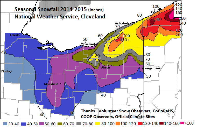
Map, Snow Totals, and Snow Observer Coordination by: Jim Kosarik, Lead Forecaster, NWS Cleveland
Seasonal Snow Totals 2014-'15 - by location.
Note that reports are from volunteer observers and not certified climate locations. If more than one report was registered for a location, the value was averaged.
Perrysburg 42.6
Findlay 35.3
Arlington 39.6
Sandusky 44.3
Fremont 49.2
Bucyrus 40.3
Huron 48.6
Milan 54.9
Bellevue 54.2
New London 54.1
Galion 55.3
Ashland 52.9
Mansfield (city) 50.3
Ontario 48.6
Walnut Creek (Holmes Cty) 36.7
Waynesburg (Stark Cty) 41.4
Jackson Twp (Stark Cty) 45.0
Massillon 39.4
East Canton 38.3
Alliance 45.5
Lorain 3 S 64.0
Elyria 67.2
North Ridgeville 62.7
Lodi 53.0
Stow 53.7
Munroe Falls 56.0
Tallmadge 54.8
Cleveland 60.6
Parma (NW) 71.5
Parma (SE) 87.4
North Royalton 90.5
Broadview Heights 95.4
Maple Heights 76.2
Solon 82.6
Euclid 64.7
Shaker Heights 85.0
Beachwood 104.4
Sagamore HIlls 75.4
Hiram 90.6
Kent 59.8
Chagrin Falls 102.3
Mentor 78.1
Burton 105.0
Chardon 116.4
Hambden Twp (Geauga Cty) 123.3
Montville (Geauga Cty) 115.5
Middlefield 82.2
Newton Falls 70.7
Conneaut 91.0
Fairview, PA 104.0
Millcreek Twp (Erie, PA) 119.0
Edinboro, PA 127.7
Colt Station, PA 178.6
Northeast, PA 151.3
Corry, PA 152.7
Springboro, PA 108.4
Crossingville, PA 135.5
Meadville, PA 104.4
Canadohta Lake, PA 124.1


 Follow us on YouTube