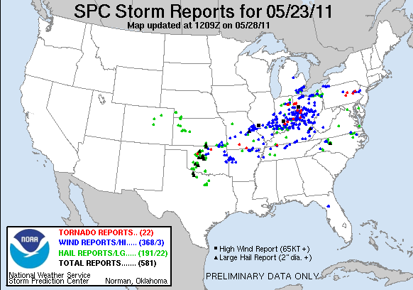
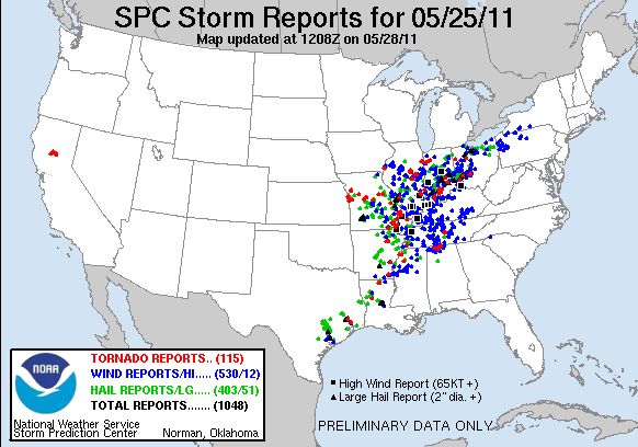
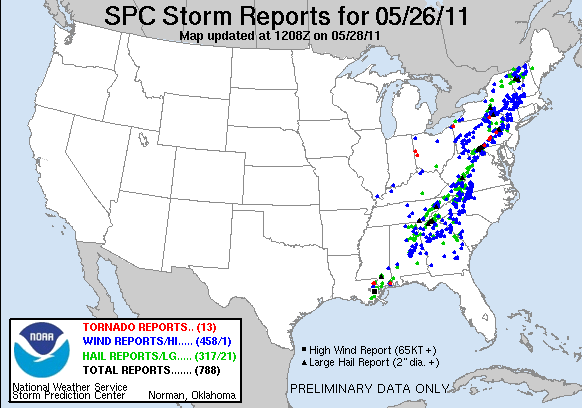
May 23-26, 2011Busy Weather Week |
|---|
Numerous Reports of Thunderstorm &
Tornado Damage
Microburst - Lorain County 5/23/11
|
Strong microburst winds of 75 to 85 MPH took down numerous trees and caused some minor roof damage to a few houses. Several telephone poles were replaced along Center Ridge Rd from trees falling onto the lines. An RV was also blown over onto its side. |
Microburst/Straight-Line Winds-
Cuyahoga County 5/23/11
|
A non-continuous path of wind damage occurred from North Olmsted to Berea to Middleburg Heights. There were several microbursts along this line where stronger winds occurred. Many trees were broken or uprooted. There were a few structures that sustained damage from trees falling onto them. |
Microburst/Straight-Line Winds-
Summit County 5/25/11
|
An intermittent path of straight line wind damage with winds of 65 to 75 MPH tracked from Fairlawn to Cuyahoga Falls. In Fairlawn at the Summit Mall a window was shattered. A roof was blown off a church and debris from the roof caused damage to a car. Numerous trees were reported down across the area with many uprooted and a few snapped high up. East of Fairlawn the damage became more sporadic with some trees down. The other concentration of damage was noted in Cuyahoga Falls where there was roof damage to several structures including a hotel, fire station, and several homes near Route 8 in downtown Cuyahoga Falls. Homes mainly sustained damage by fallen trees just east of Route 8 between Tallmadge and Bailey Roads. Some large trees were sheared near their tops in Cuyahoga Falls. The large trees that were sheared or snapped near their tops lead to some indication there may have been an elevated funnel cloud associated with this storm. However, assessment of the damage indicated that rotation did not reach the ground. |
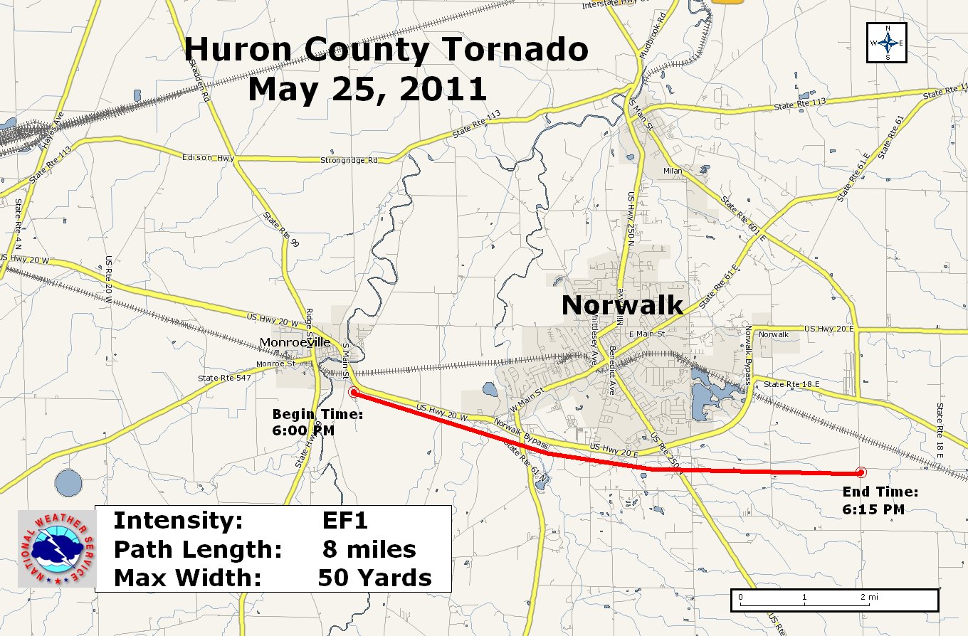
Tornado Confirmed - Huron County 5/25/11
|
Initial touchdown of the tornado occurred on the southeast side of Monroeville near a cemetery. The beginning of the track indicated mainly a downed tree but primarily tracked through farm fields. The tornado continued east and crossed Halfway Rd. south of U.S. Route 20. A barn located along Halfway Rd. was destroyed. The tornado continued east, south of U.S. Route 20 and lifted near the intersection of North Greenwich Milan Town Line Road and Tiger Road southeast of Norwalk. Approximately 10 to 12 homes and several businesses were damaged. There were a few roofs blown off homes while others had trees falling on them causing damage. The businesses experienced primarily roof damage. The majority of the downed trees were observed east of Halfway Rd. along the tornado path. |
||||||||||||||||
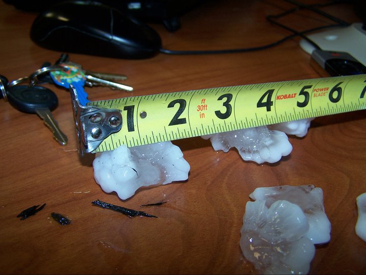
|
Hail observed from this same storm. |
|||||||||||||||||
|
Approximate path of tornado. |
|||||||||||||||||
Straight-line Winds- Ashtabula County 5/25/11
|
Straight line winds from a thunderstorm caused damage with a track beginning near the Geneva High School and Kiwanis Park. A house near the high school had significant roof damage with a portion of the roof blown off. The damage path continued to the northeast. Significant damage was also noted in a neighborhood to the west of South Meyers Rd. just south of U.S. Route 20. Several homes in the neighborhood were damaged mainly by downed trees and large limbs. In total eight to ten homes sustained some damage along the path. |
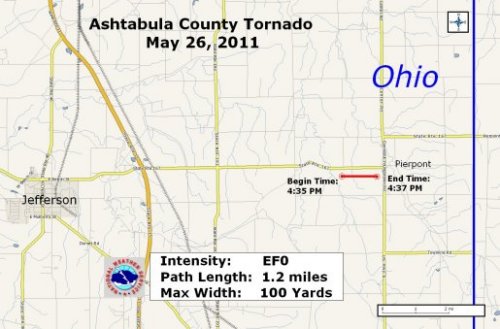
Tornado Confirmed- Ashtabula County 5/26/11
|
The tornado touchdown was observed just southwest of the intersection of State Route 167 and Lewis Road. The tornado continued eastward along State Route 167 before lifting just before the intersection of State Route 167 and State Route 7 in the center of Pierpont. Ten structures were damaged...mainly roofs and siding. Two farm outbuildings lost roofs. Evidence of downburst winds were observed in addition to the tornado. |
||||||||||||||
|
Approximate path of tornado. |
|||||||||||||||
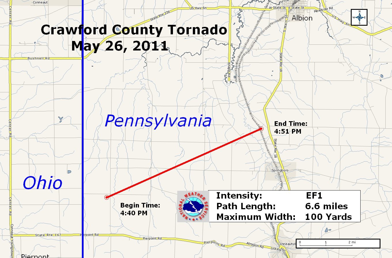
Tornado Confirmed- Crawford County PA 5/26/11
|
The touchdown of the tornado occurred near the intersection of Artman Rd. and Reeds Corner Rd. north of State Route 198 and just east of the Ohio/PA border. The tornado continued northeast and lifted near Angling Rd north of Springboro. Ten structures were damaged (mainly roof damage). One building had its roof turn off. Numerous trees were downed along the path. |
||||||||||||||
|
Approximate path of tornado. |
|||||||||||||||


 Follow us on YouTube