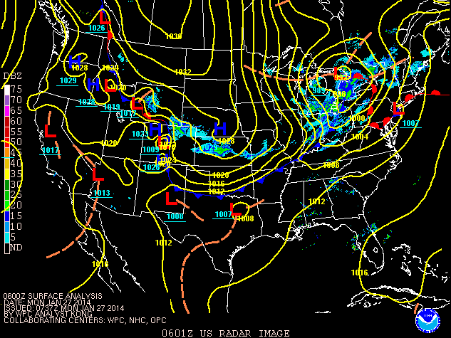
 Cold Front Brings 3rd Cold Snap of the Season - January 27th
Cleveland had a temperature drop from 38 degrees shortly after midnight on 1/27 to 4 degrees by that evening. The temperature dropped further to -9 during the early morning hours on 1/28. A temperature drop like this was common as this cold front ushered in yet another unseasonably cold airmass.
Peak wind gusts during the middle of the night (1/27) were between 40 and 60 MPH. Up to a couple of inches of snow fell too overnight.
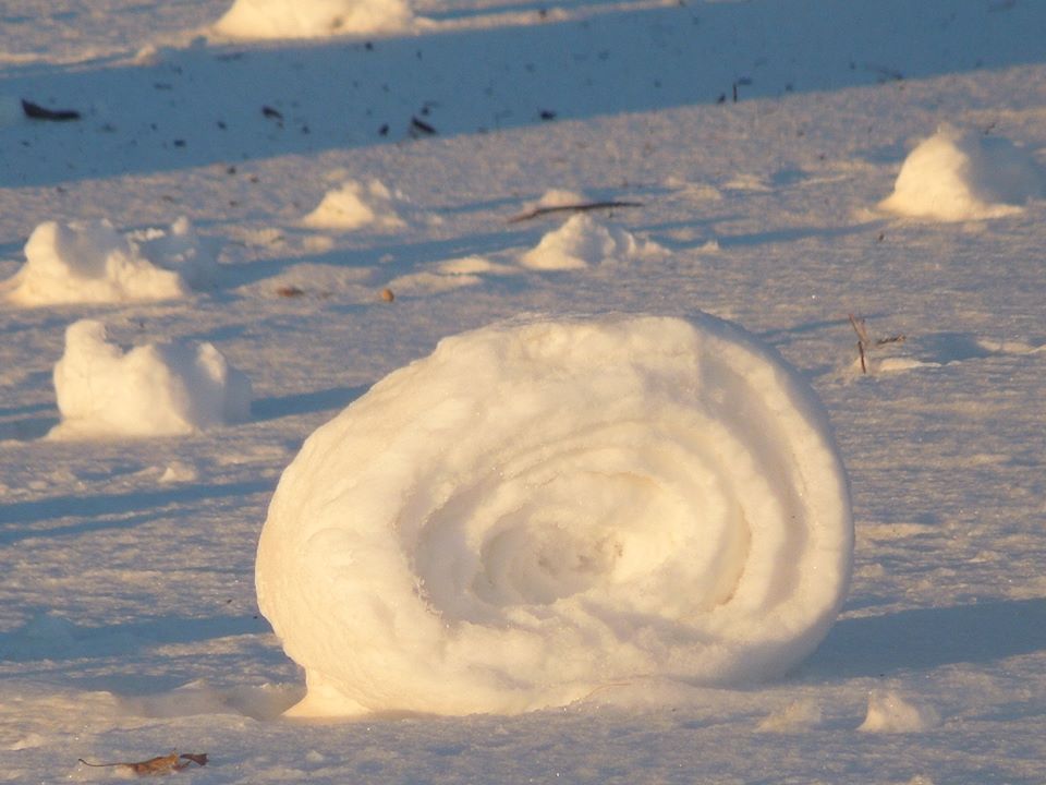
People all across the area woke up (on 1/27) to see a rare phenomenon: snow rollers. These wind driven balls of snow need just the right conditions to form and this was the night.
The following pictures are from:
Mrs. Jill Tunnicliffe Scholes on 28 Jan 2014 in Findlay, Ohio


******PEAK WIND GUSTS FOR JANUARY 27 2014*******

LOCATION                          PEAK WIND
                                    /MPH/

OHIO

...ASHTABULA COUNTY...
   ASHTABULA COUNTY AIRPORT          48

...CUYAHOGA COUNTY...
   BURKE LAKEFRONT AIRPORT           60
   CLEVELAND HOPKINS AIRPORT         53

...HANCOCK COUNTY...
   FINDLAY AIRPORT                   51

...LORAIN COUNTY...
   LORAIN COUNTY AIRPORT             55

...LUCAS COUNTY...
   TOLEDO EXECUTIVE AIRPORT          53
   TOLEDO EXPRESS AIRPORT            45

...MARION COUNTY...
   MARION MUNICIPAL AIRPORT          43

...RICHLAND COUNTY...
   MANSFIELD LAHM AIRPORT            52

...SUMMIT COUNTY...
   AKRON CANTON AIRPORT              30
   AKRON FULTON AIRPORT              45

...TRUMBULL COUNTY...
   YOUNGSTOWN WARREN AIRPORT         45

...WAYNE COUNTY...
   WAYNE COUNTY AIRPORT              49


PENNSYLVANIA

...CRAWFORD COUNTY...
   PORT MEADVILLE AIRPORT            40

...ERIE COUNTY...
   ERIE INTERNATIONAL AIRPORT        40


 Follow us on YouTube