Heavy Rain and Gale Force Winds Produce Flooding in NW Ohio
June 26-27, 2015
An intense low pressure system developed over the Southern Plains, in conjunction with an upper-level trough. This low pressure system developed much like a winter weather system, as the storm deepened as it progressed eastward. The upper-level low also became a closed-low, which is typical of a winter system. The slow movement of this system brought extremely heavy rain to northern Ohio with some locations in NW Ohio receiving up to 6” of rain in a 28 hour period. Several areas in Northwest Ohio were flooded due to excess rainfall and standing water was high in area ditches and fields. Homes in Avon Lake and Bay Village once again had flooding issues, as this area received another 2.5-3” of rain and did not fully recover from excessive rainfall from earlier in the week.
Winds were very strong with this system as it approached from the southwest. Gale force winds were recorded on portions of Lake Erie and strong northeast winds caused lakeshore flooding in Lucas, Ottawa, and Sandusky counties. Several trees and large branches fell with the strong winds and the high amounts of water that fell through the month of June.
Many rivers in northern Ohio flooded. The Cuyahoga River at Independence and the Portage River at Woodville both went into major flood. The Maumee River at Grand Rapids and Waterville approached 100 year flood levels and water entered businesses in the downtown district of Grand Rapids.
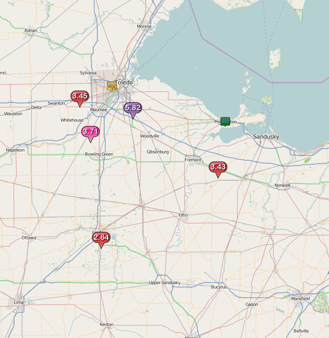
Local Storm Report Map Courtesy of the Iowa Environmental Mesonet (IEM) from Iowa State University.
Here are the Preliminary Storm Reports from June 26-27, 2015:
PRELIMINARY LOCAL STORM REPORT
NATIONAL WEATHER SERVICE CLEVELAND OH
116 AM EDT SUN JUN 28 2015

..TIME...   ...EVENT...      ...CITY LOCATION...     ...LAT.LON...
..DATE...   ....MAG....      ..COUNTY LOCATION..ST.. ...SOURCE....
            ..REMARKS..

1159 PM     HEAVY RAIN       2 W MILLBURY            41.56N 83.46W
06/27/2015  M5.82 INCH       WOOD               OH   ASOS

            SINCE 9PM FRIDAY.

1159 PM     HEAVY RAIN       10 WSW TOLEDO           41.61N 83.76W
06/27/2015  M3.45 INCH       LUCAS              OH   ASOS

            SINCE 8PM FRIDAY.

1159 PM     HEAVY RAIN       HASKINS                 41.46N 83.70W
06/27/2015  M3.71 INCH       WOOD               OH   COCORAHS

            IN LAST 24 HOURS.

1159 PM     LAKESHORE FLOOD  PORT CLINTON            41.51N 82.94W
06/27/2015                   OTTAWA             OH   BROADCAST MEDIA

            NUMEROUS REPORTS OF FLOODING ALONG PERRY STREET AND
            LAKESHORE DRIVE.

1159 PM     FLOOD            PORT CLINTON            41.51N 82.94W
06/27/2015                   OTTAWA             OH   NEWSPAPER

            SEVERAL STATE ROUTES CLOSED ACROSS OTTAWA COUNTY.

1159 PM     HEAVY RAIN       2 S FINDLAY             41.01N 83.64W
06/27/2015  M2.64 INCH       HANCOCK            OH   OTHER FEDERAL

            24 HOUR RAIN.

1159 PM     HEAVY RAIN       CLYDE                   41.31N 82.98W
06/27/2015  M3.43 INCH       SANDUSKY           OH   PUBLIC

            24 HOUR RAIN.

1159 PM     NON-TSTM WND DMG TOLEDO                  41.66N 83.58W
06/27/2015                   LUCAS              OH   BROADCAST MEDIA

            SEVERAL REPORTS OF TREES AND BRANCHES DOWN ACROSS CITY.


&&

$$

MITCHELL


 Follow us on YouTube