|
This briefing is updated for significant weather events. |
| Weather Hazard Outlooks | |
|
|
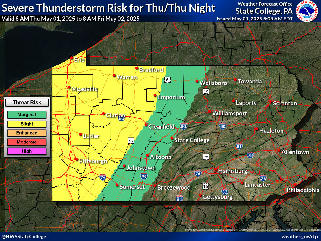
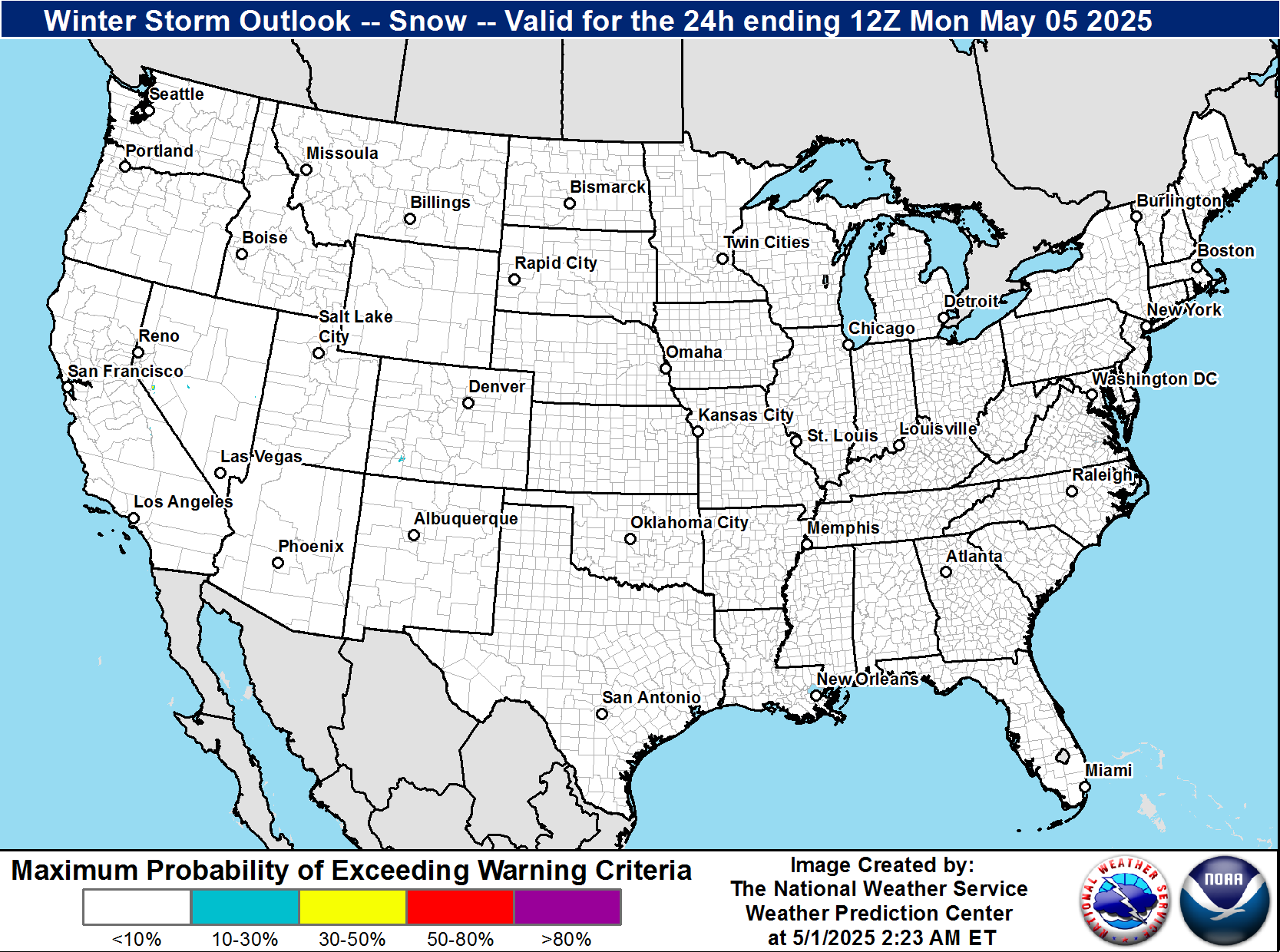
| Day 1 Severe Weather Outlook | |
| Click image to view Outlooks for Days 1-8 | |
 |
|
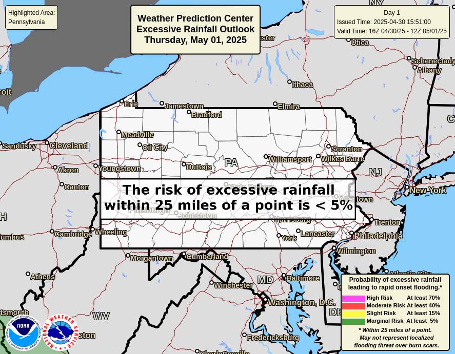
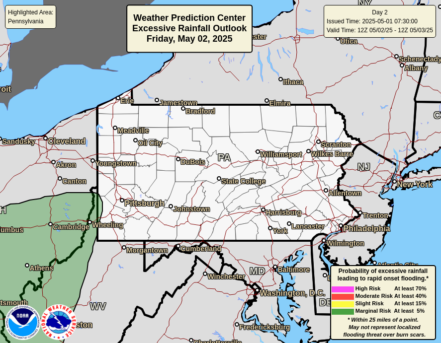
| Day 1 Excessive Rainfall Outlook | |
| Click image to view Outlooks for Days 1-3 | |
 |
|
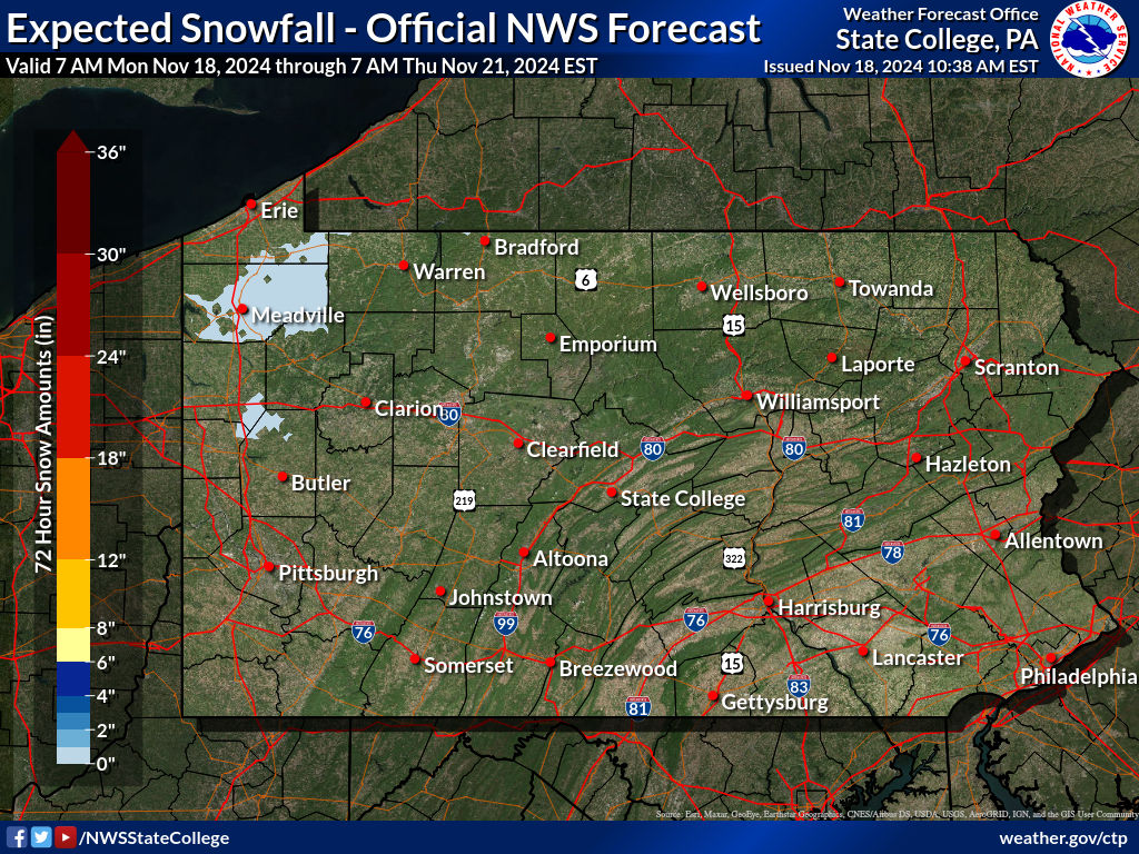
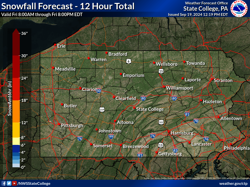
| Snow & Ice Forecasts | |
 |
|
 |
|
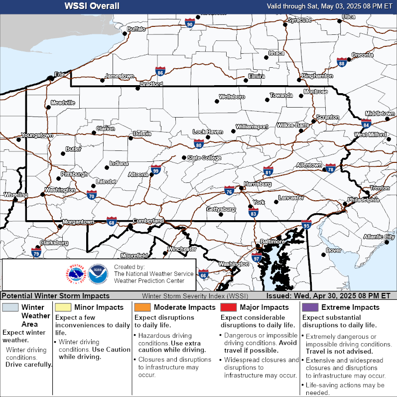
| Days 1-3 Winter Storm Severity Index | |
 |
| Current Weather Story | Surface Map Forecast |
 |
 |
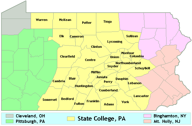
| NWS State College Weather Synopsis |

 NWS State College, PA Radar Loop |
 Cleveland, OH |
 Buffalo, NY |
 Binghamton, NY |
 Pittsburgh, PA |
 Sterling, VA |
 Mount Holly, NJ |
|
| Click Here for Regional Radar Mosaic | |||
 GeoColor Satellite Image |
 Infrared Satellite Image Infrared Satellite Image |
 Water Vapor Image |
GOES-East Visible |  |
| GOES-East Lightning Mapper |  |
|||
| GOES-East Infrared |  |
|||
| GOES-East Water Vapor |  More Imagery More Imagery |
|||
| Click Here for Satellite Imagery Zoomed in on Central PA | ||||
 United States Surface Analysis |
 United States Surface Analysis with Radar |
 US Surface Temps | N America | World |
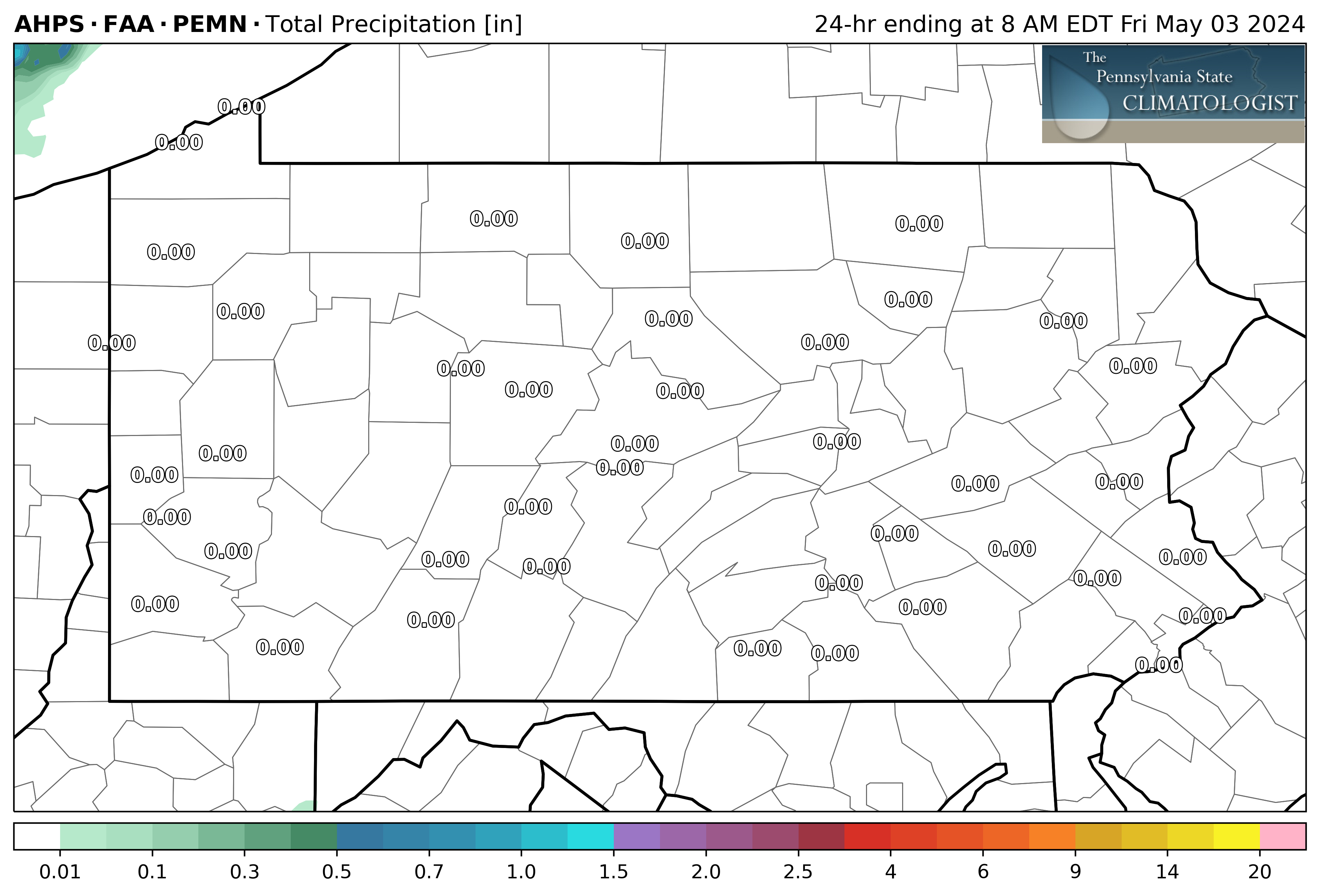
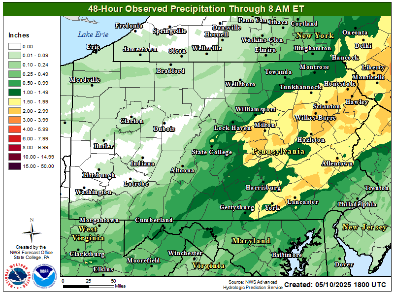
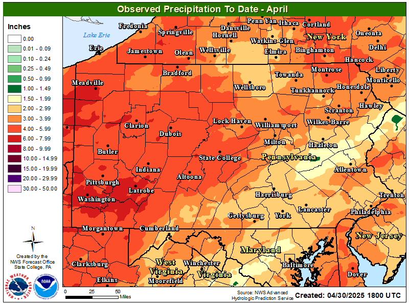
| How Much Rain Has Fallen? | ||
| Last 24 Hours | Last 48 Hours | Month to Date |
 |
 |
 |
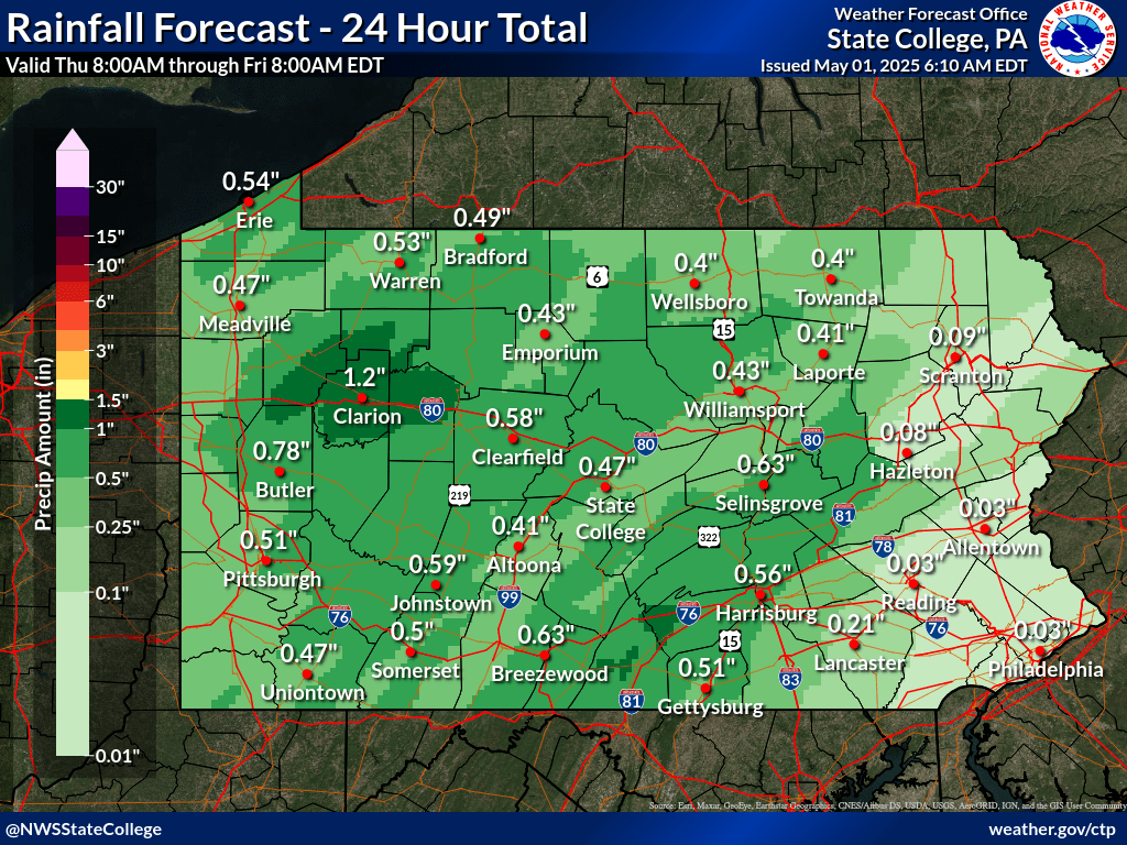
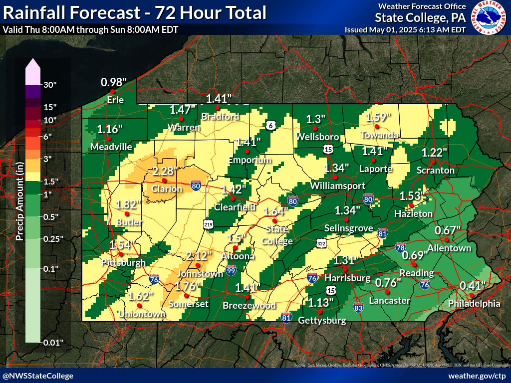
| Precipitation Forecasts | |||
| Day 1 | Days 1-2 | Day 1-3 | |
 |
 |
 |
|
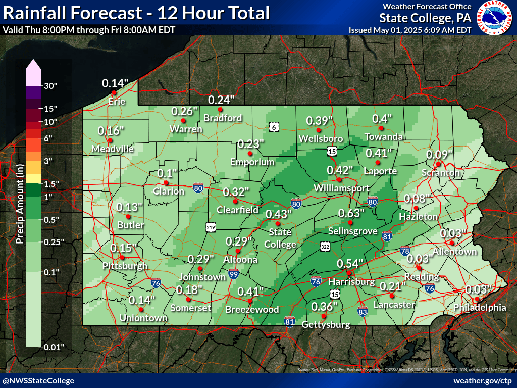
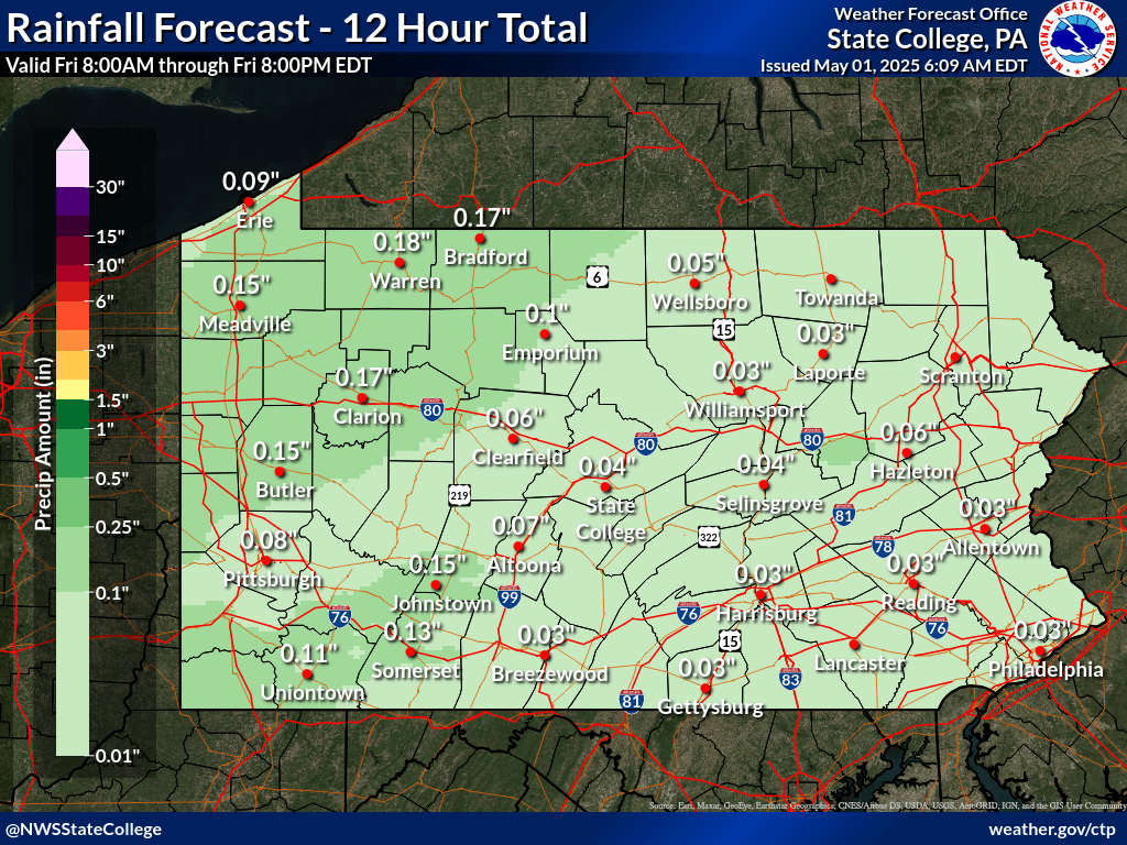
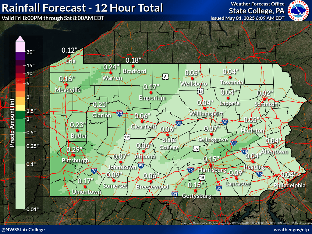
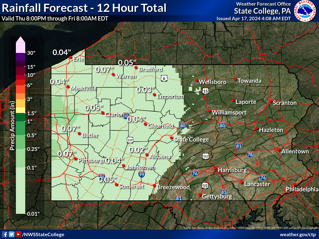
| 0 to 12 hours | 12 to 24 hours | 24 to 36 hours | 36 to 48 hours | 48 to 60 hours | 60 to 72 hours |
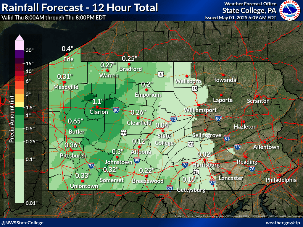 |
 |
 |
 |
 |
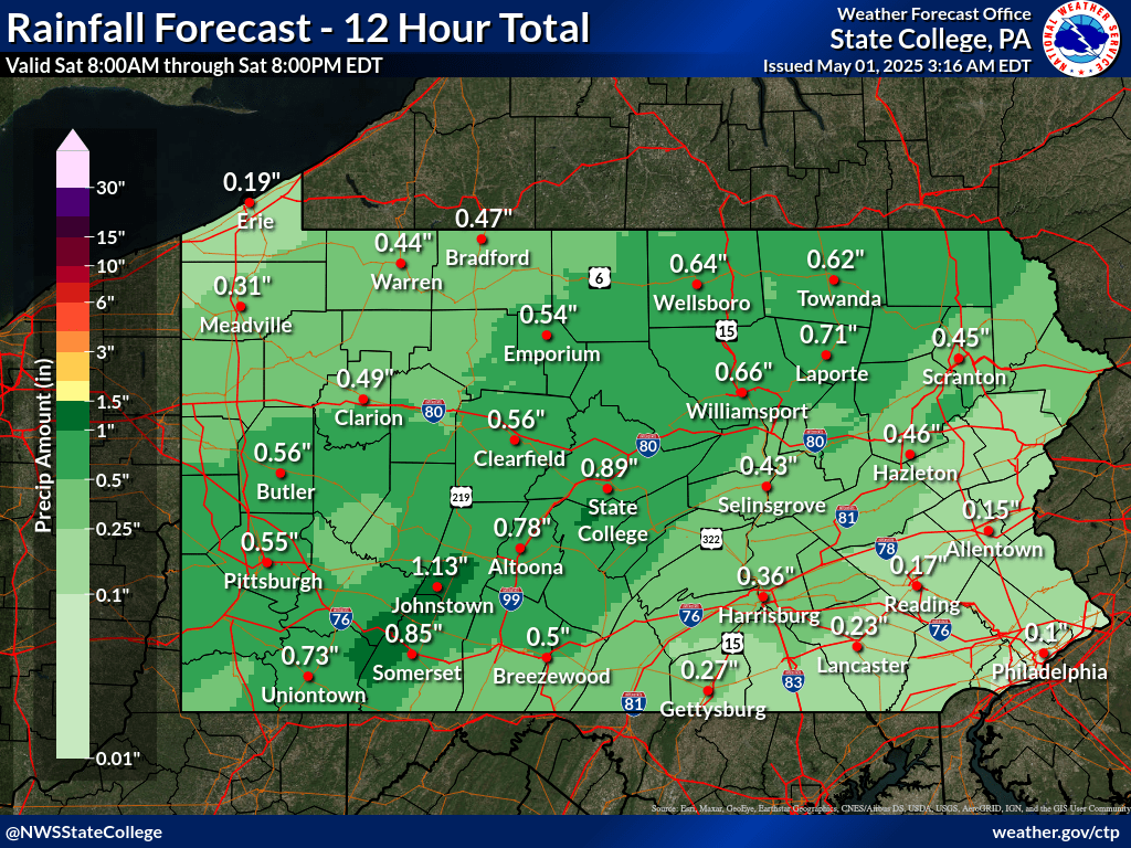 |
| Click Here for Precipitation forecasts for the next 7 days | |||||
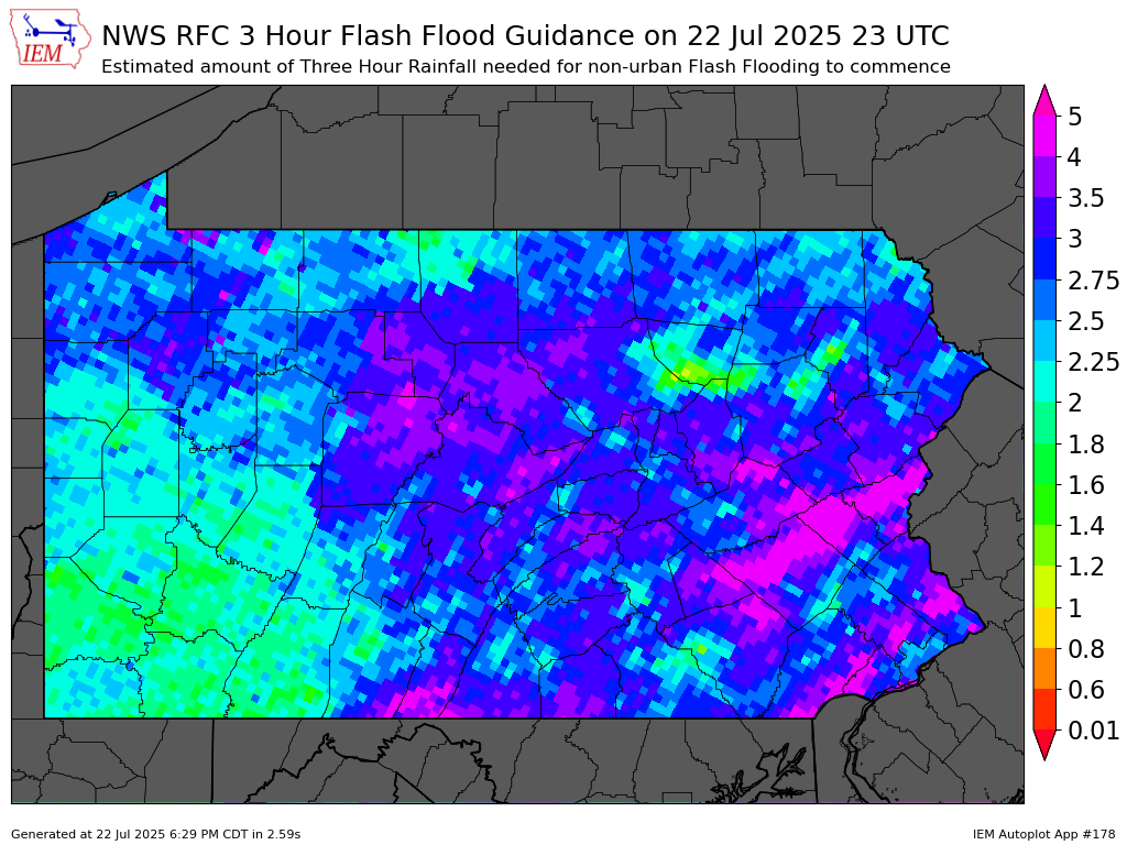
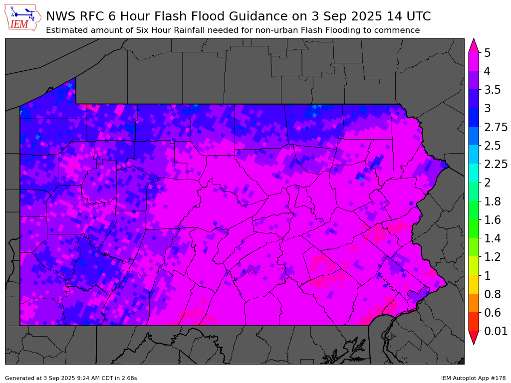
| Flash Flood Guidance |
Flash Flood Guidance (FFG) provides a general indication of the amount of rainfall evenly distributed over various durations (in hours), necessary to cause small streams to overflow their natural banks. During heavy rainfall, accurate interpretation of the guidance consists of the combination of rainfall that has already occurred plus any additional rainfall that can be confidently expected to fall over the same location in the immediate future.
It should be noted that FFG values represent estimates of average soil moisture and stream flow conditions. Flooding may occur with less rainfall than indicated in areas of high rainfall intensities, impervious surfaces, or steep slopes.
| 1 Hour | 3 Hour | 6 Hour |
 |
 |
 |
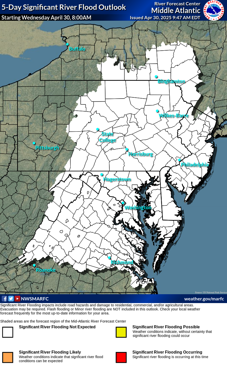
| Day 1 Excessive Rainfall Outlook | Day 2 Excessive Rainfall Outlook | Day 3 Excessive Rainfall Outlook | Middle Atlantic Flood Outlook |
|
 |
 |
 |
| Day 1 Precipitation | Day 2 Precipitation | Day 3 Precipitation |
 |
 |
 |
| Day 4-5 Precipitation | Day 6-7 Precipitation | 7-Day Total Precipitation |
 |
 |
 |
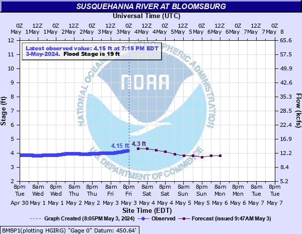
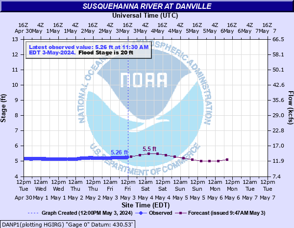
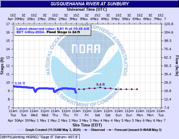
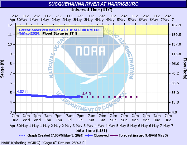
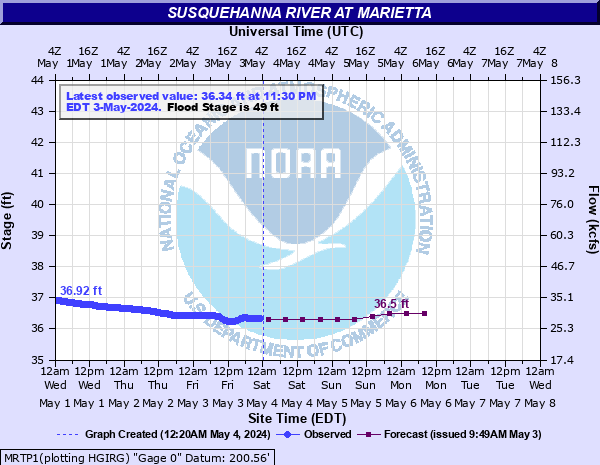
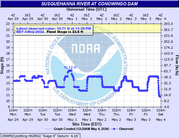
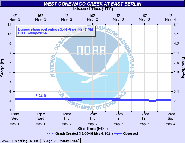
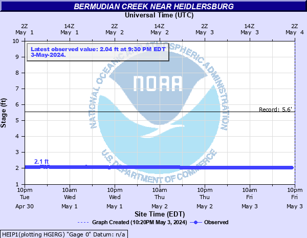
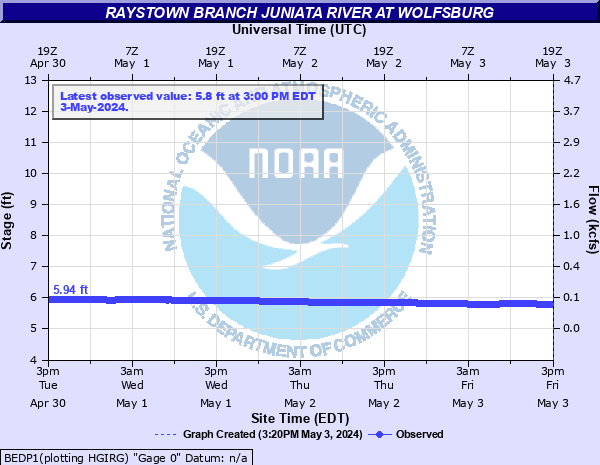
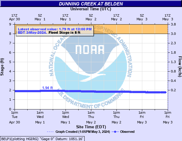
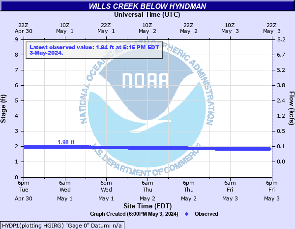
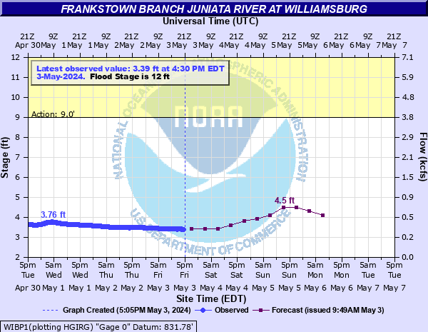
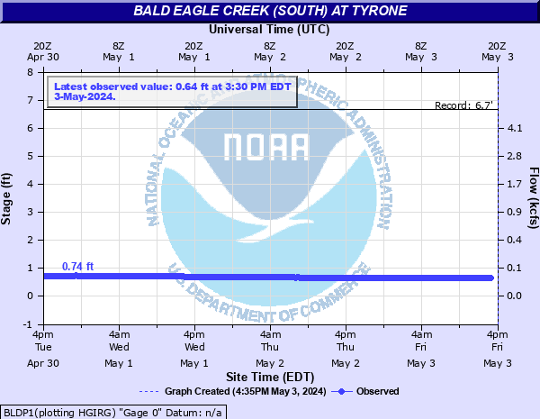
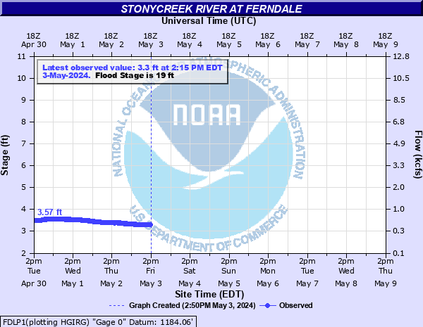
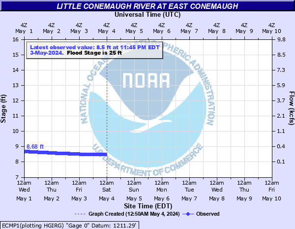
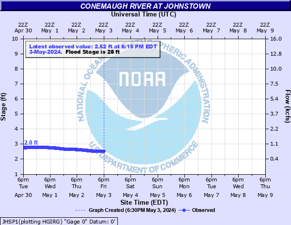
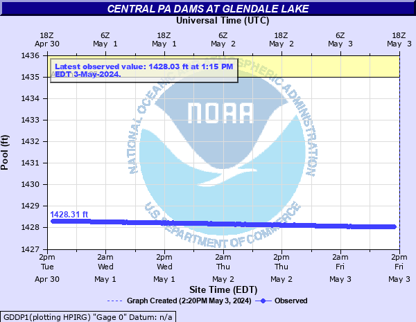
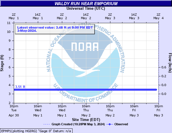
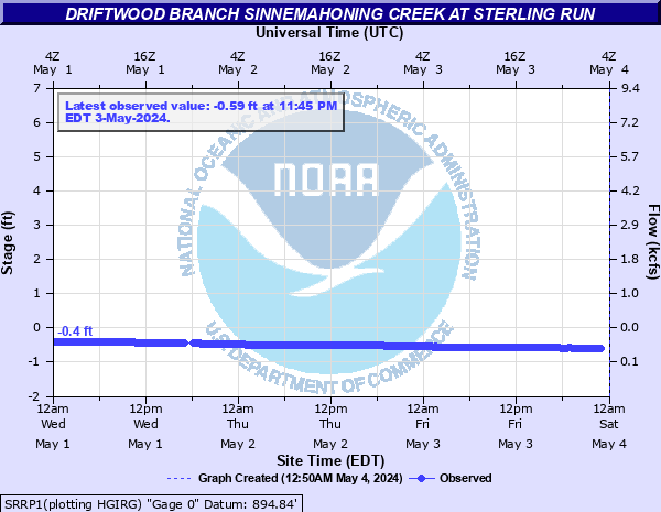
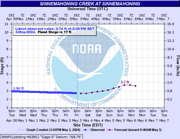
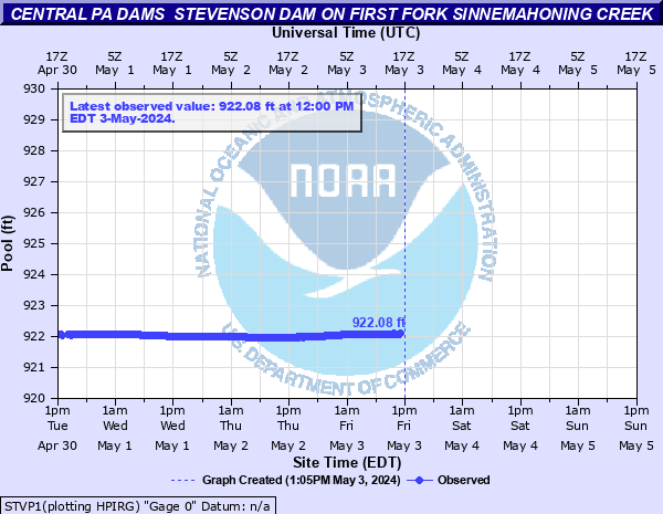
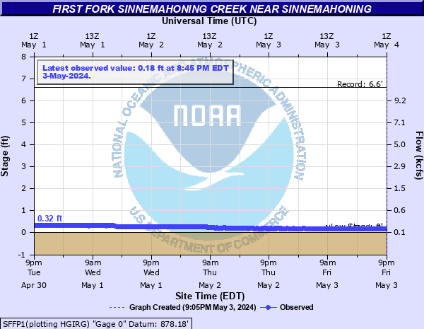
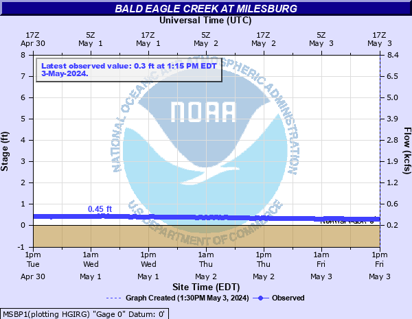
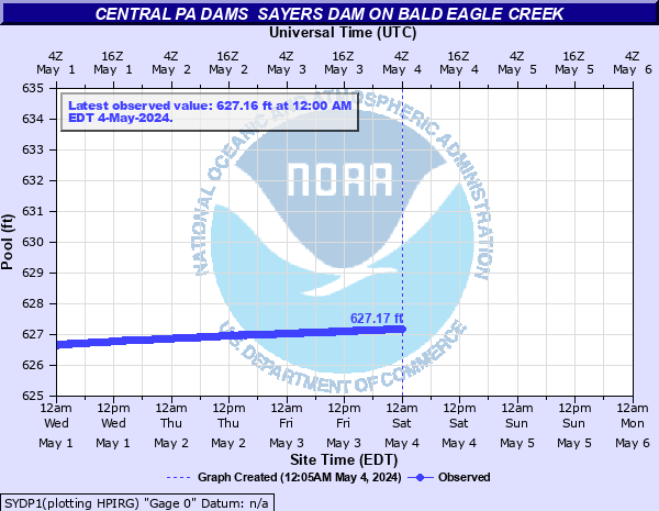
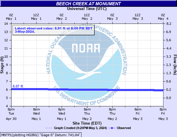
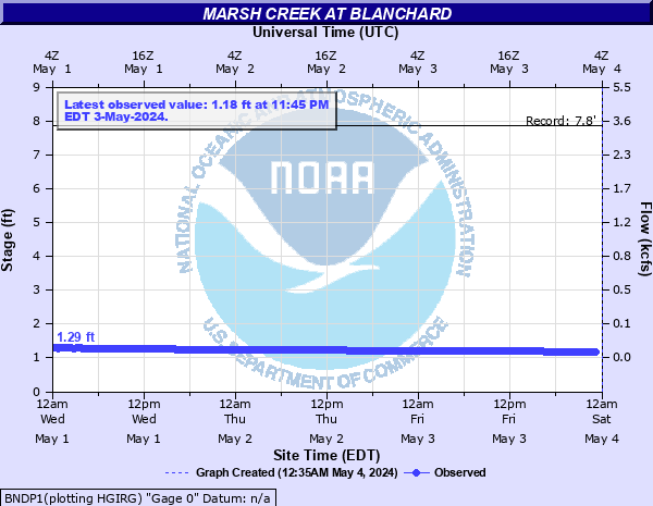
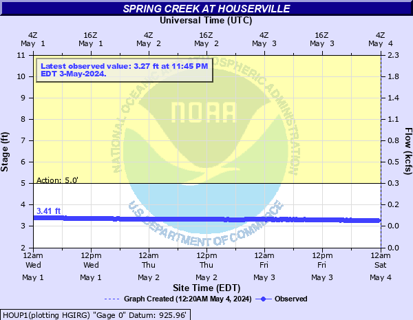
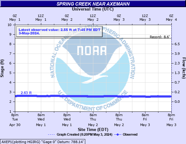
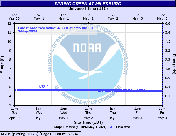
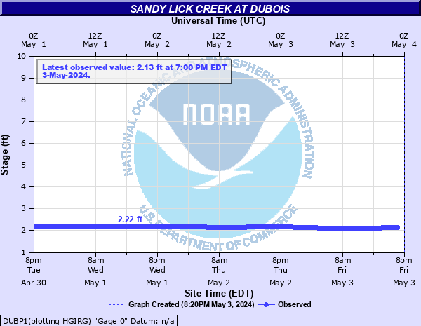
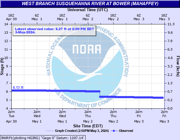
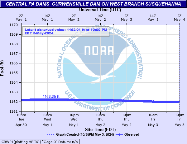
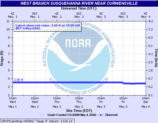
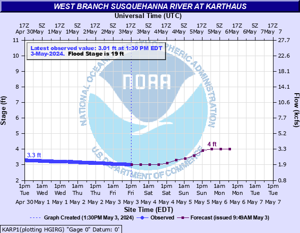
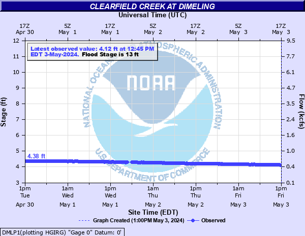
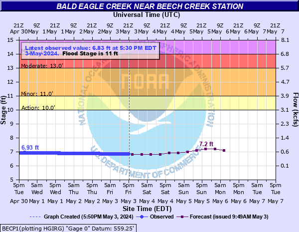
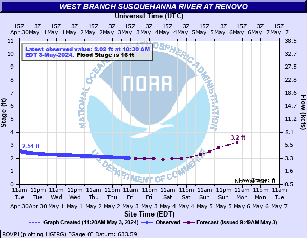
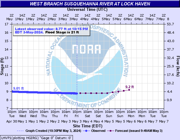
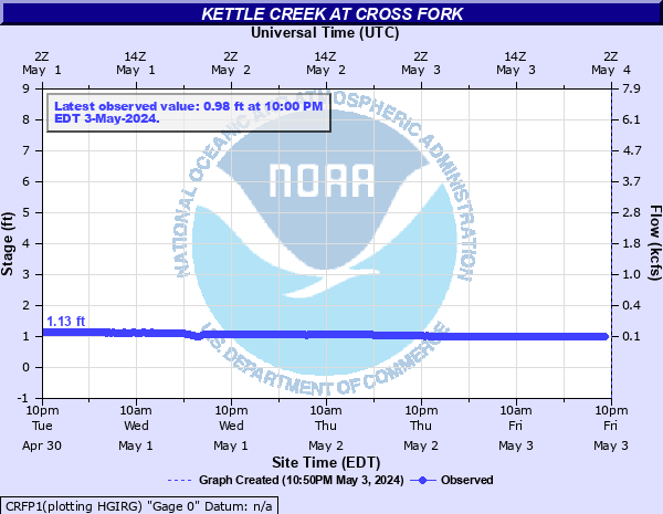
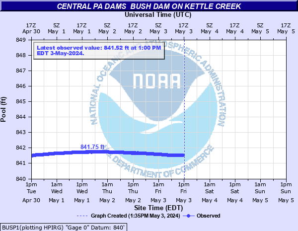
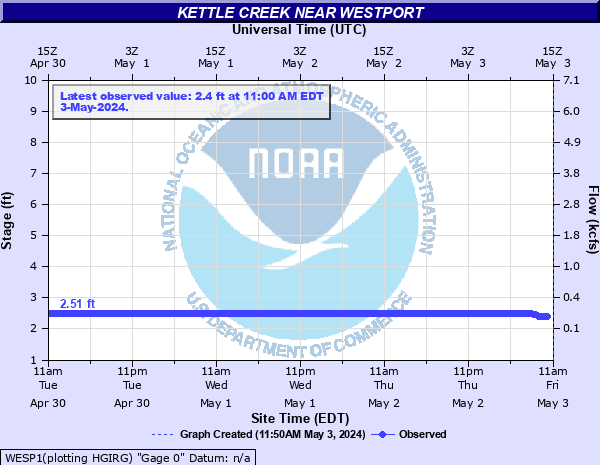
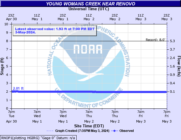
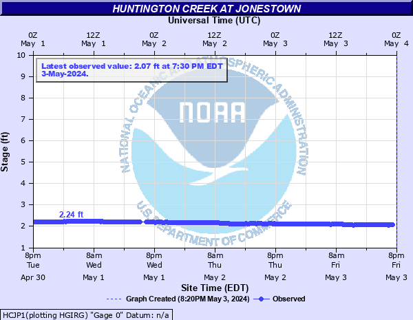
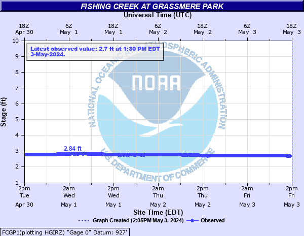
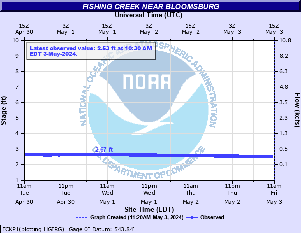
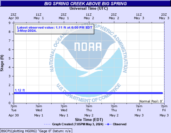
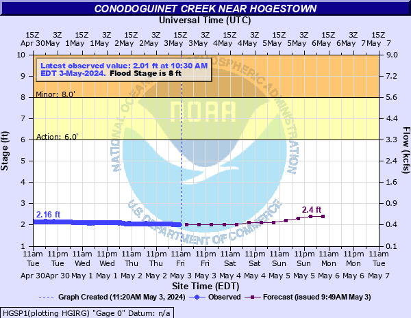
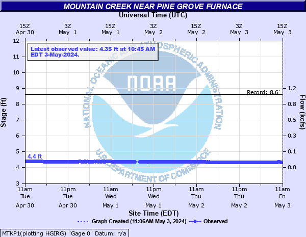
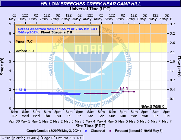
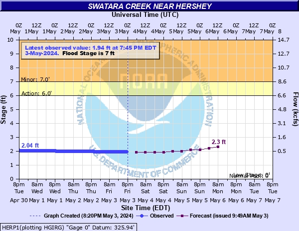
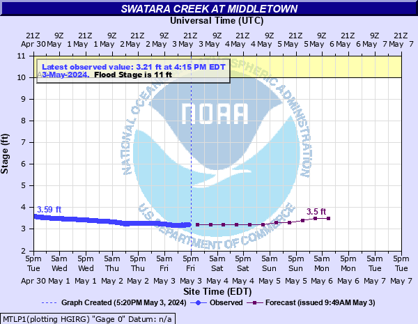
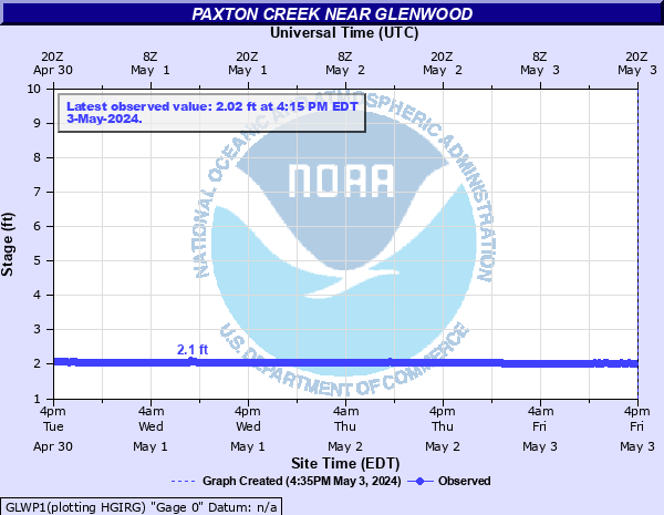
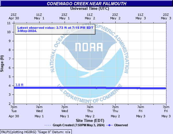
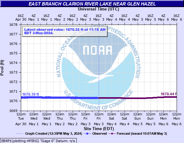
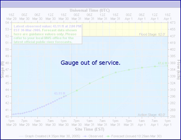
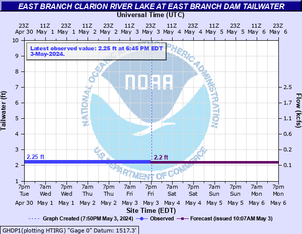
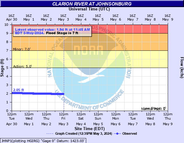
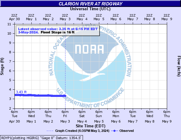
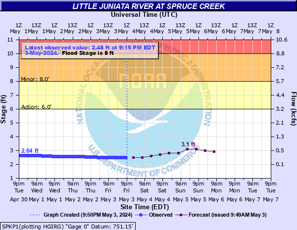
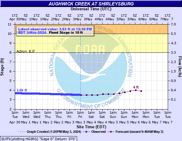
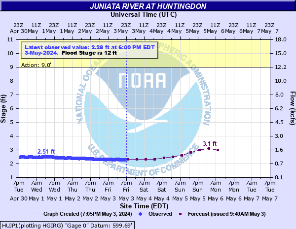
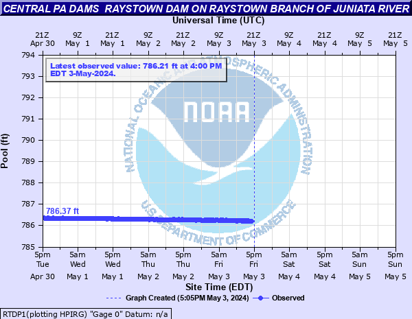
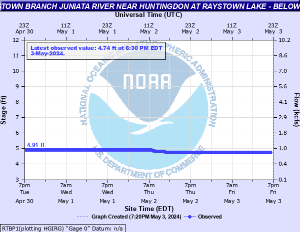
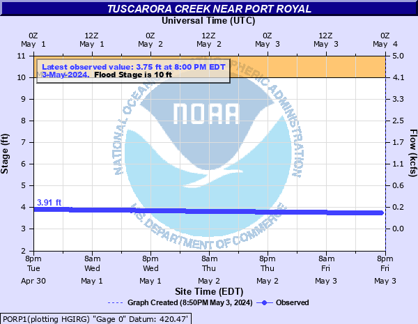
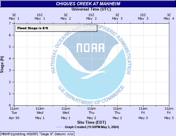
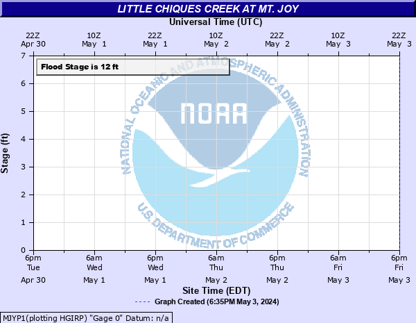
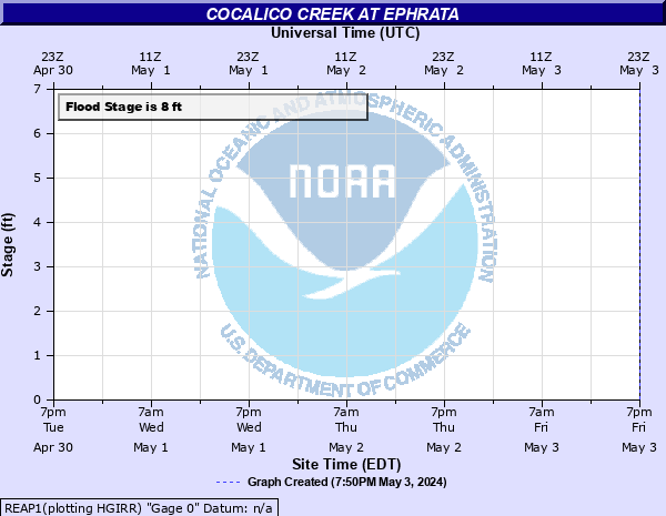
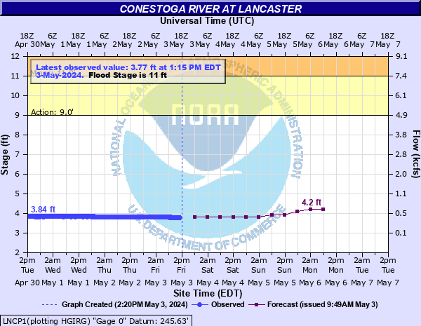
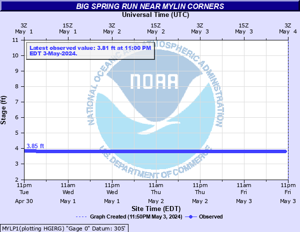
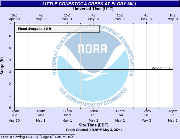
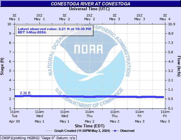
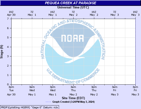
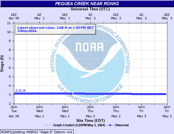
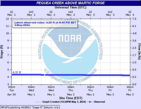
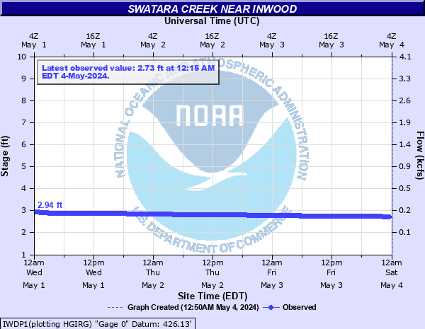
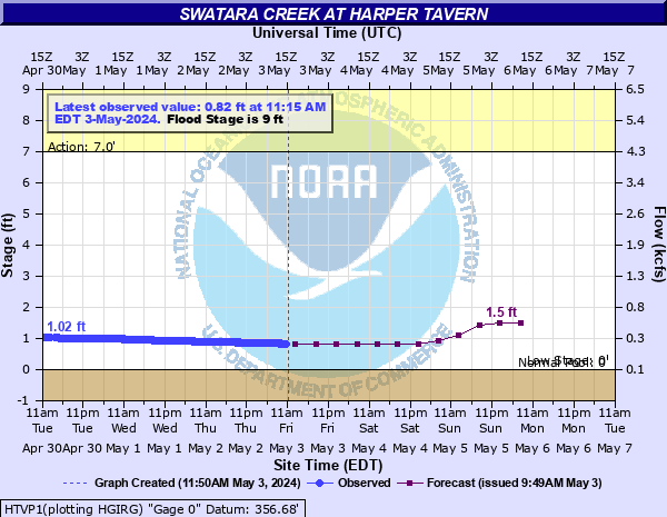
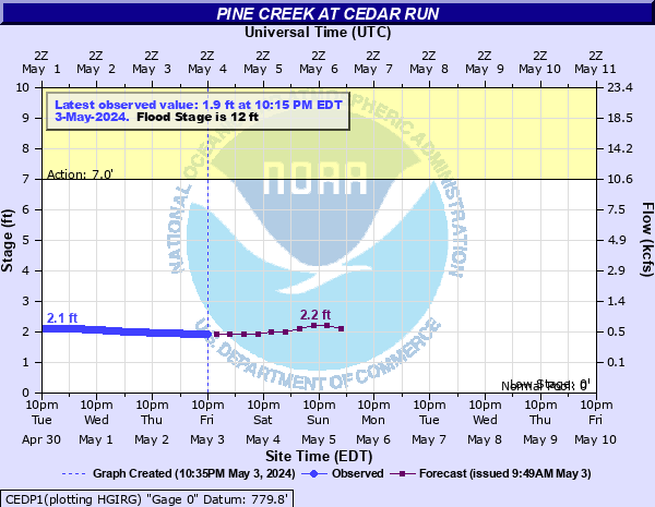
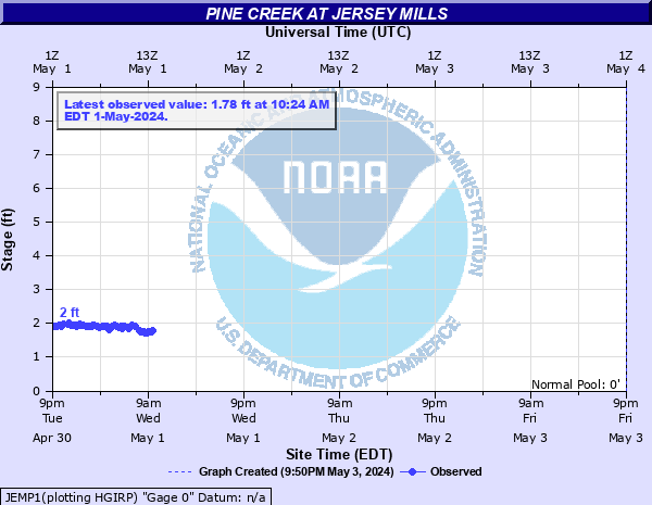
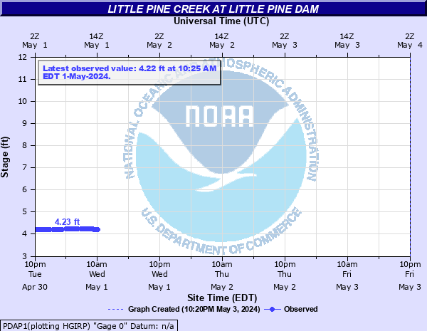
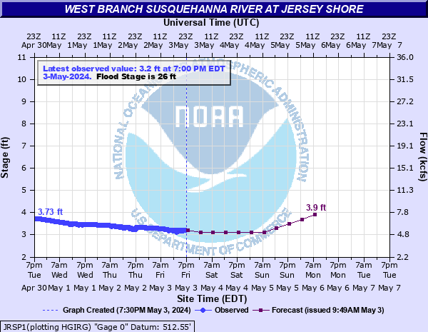
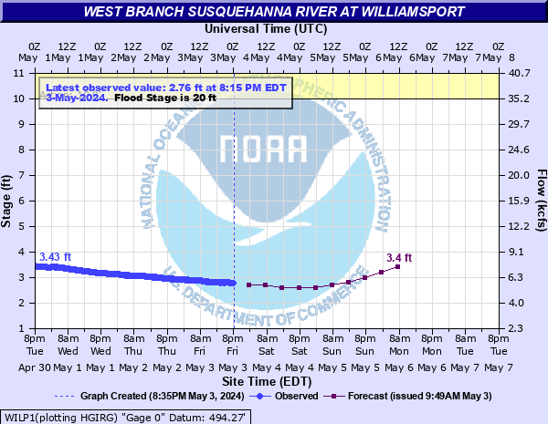
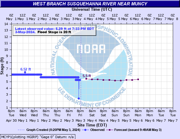
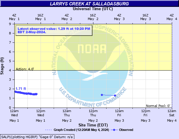
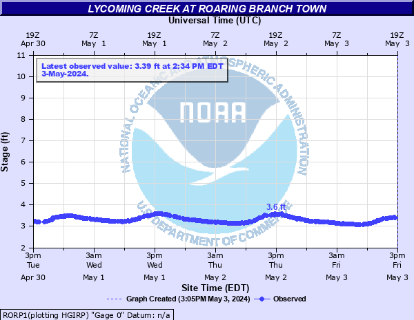
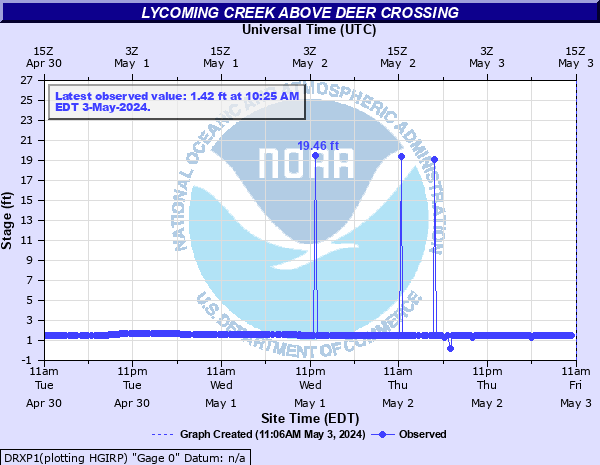
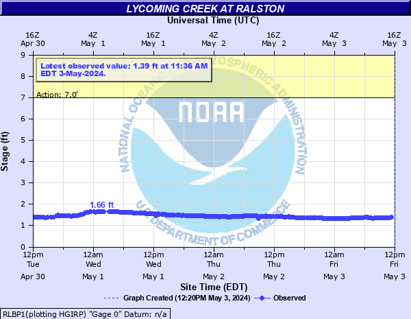
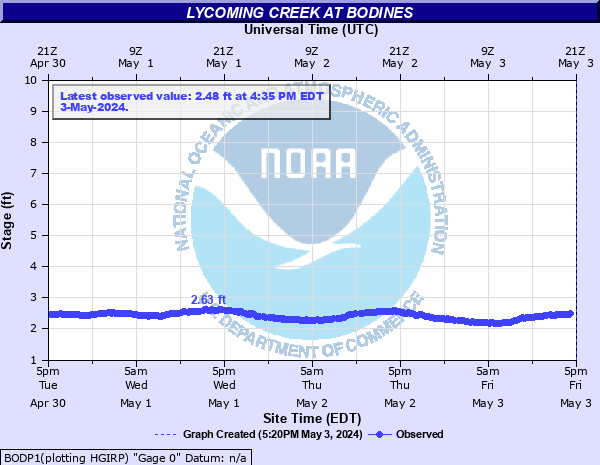
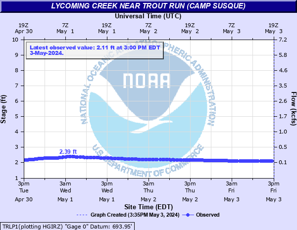
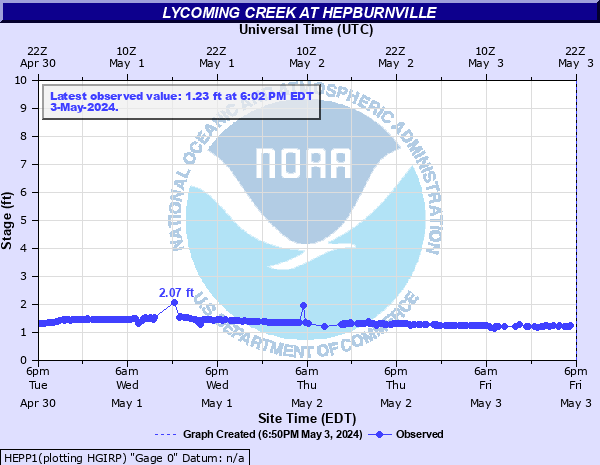
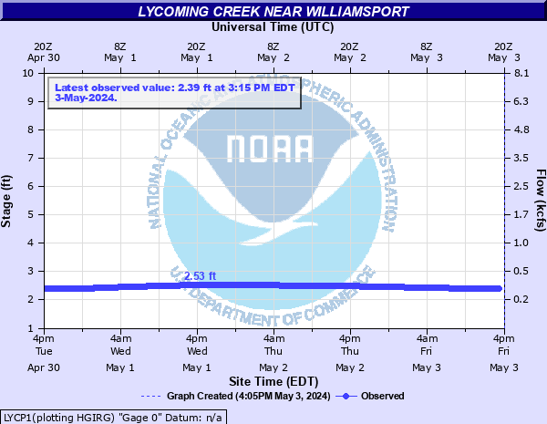
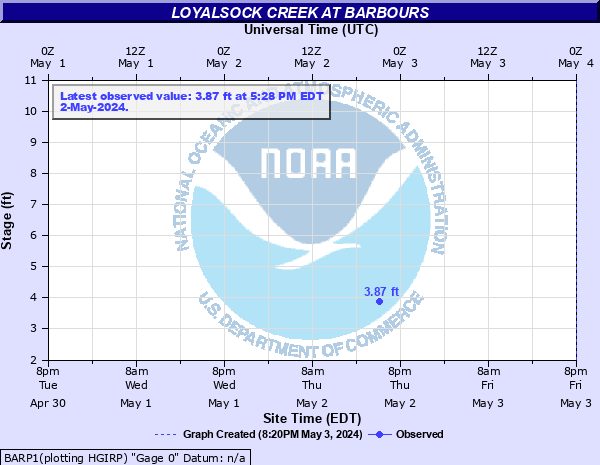
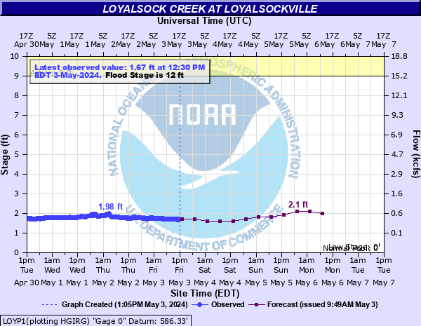
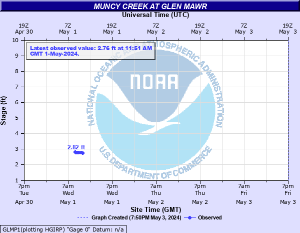
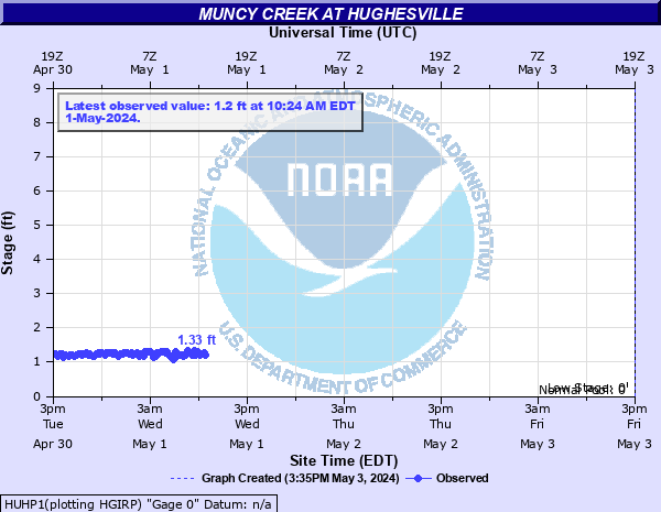
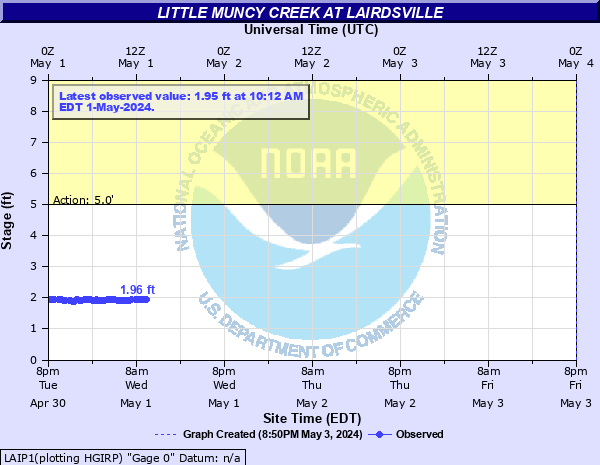
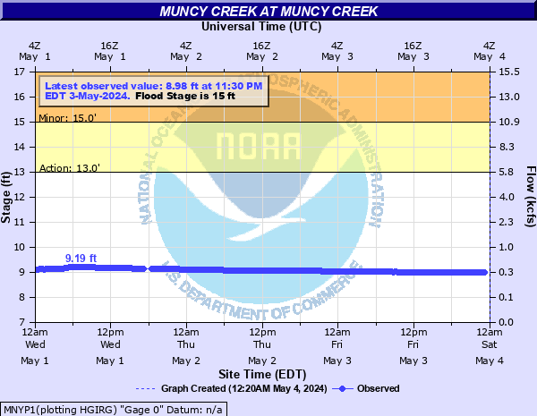
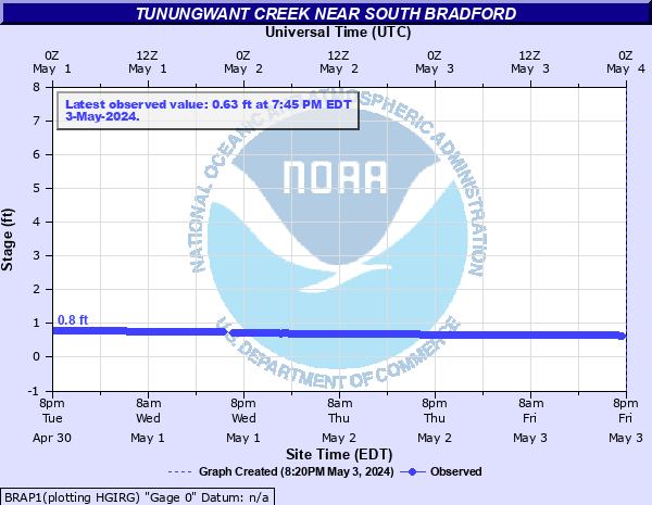
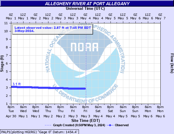
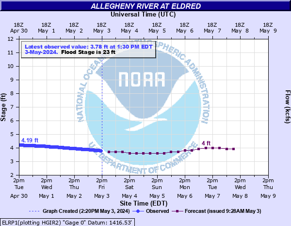
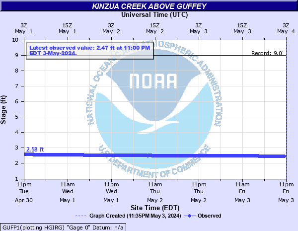
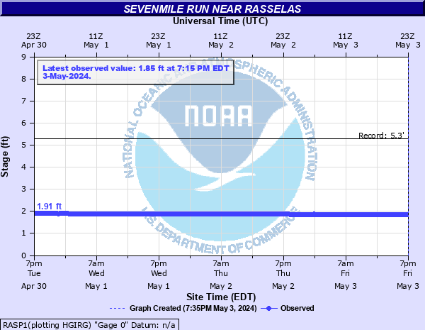
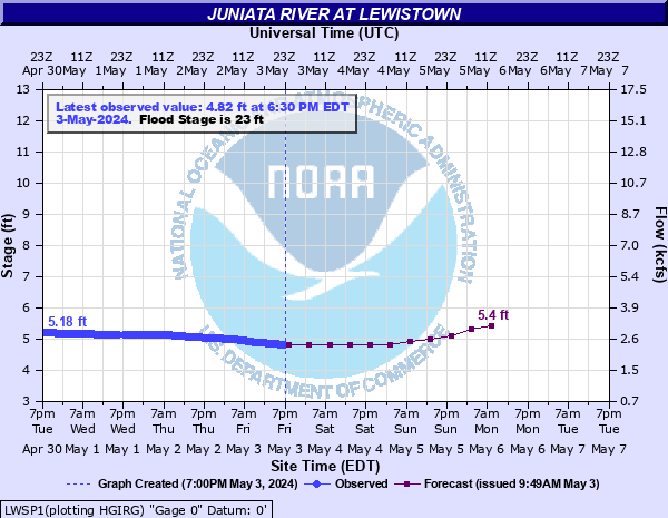
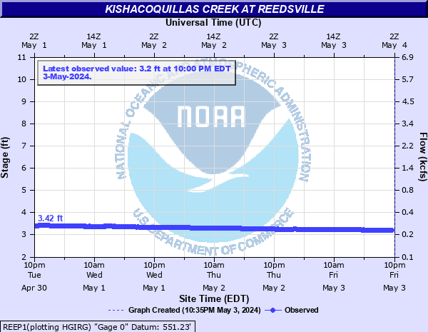
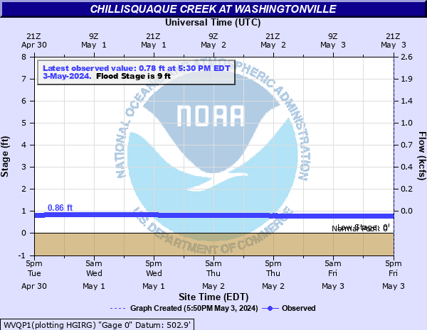
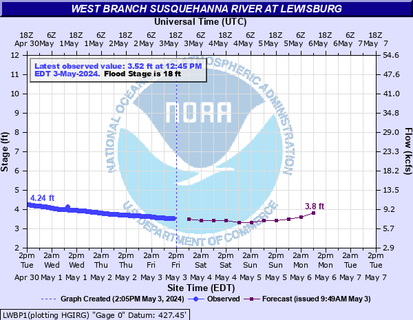
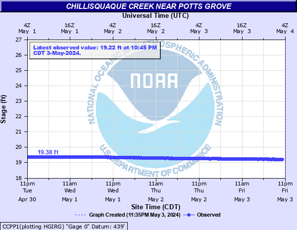
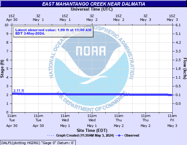
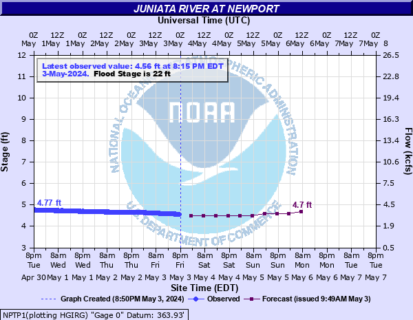
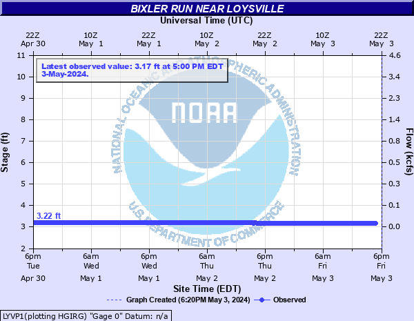
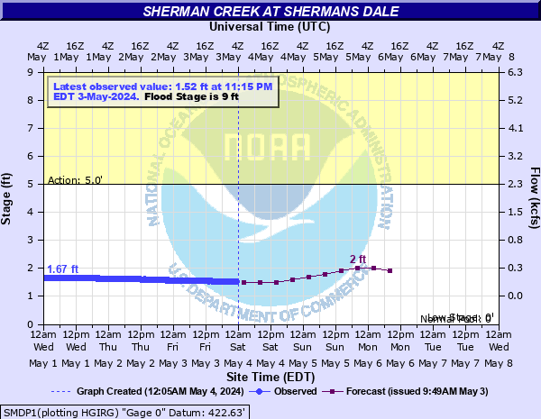
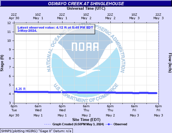
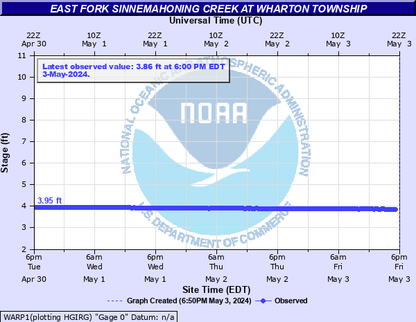
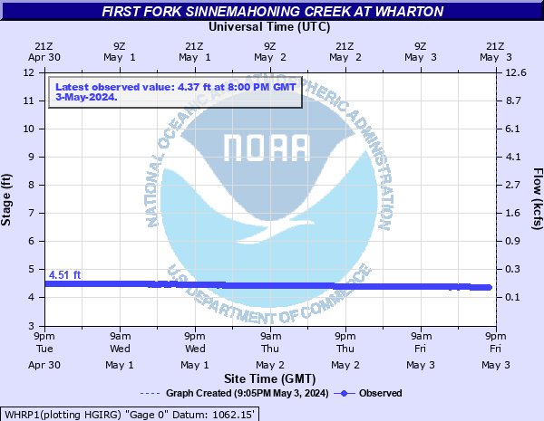
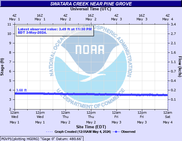
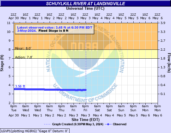
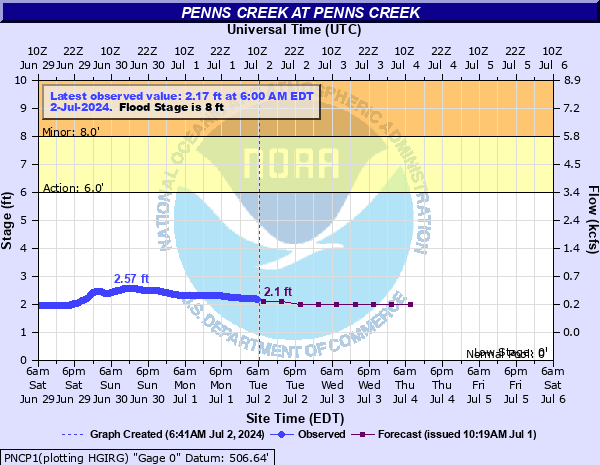
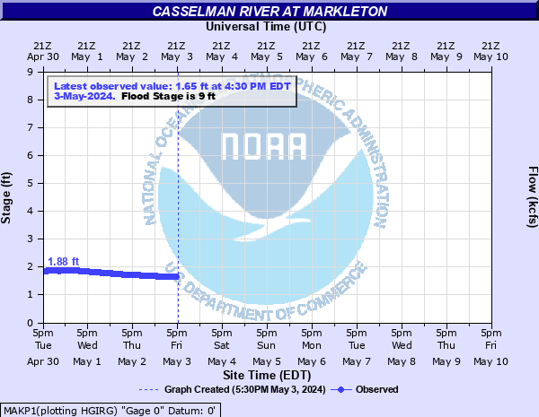
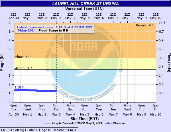
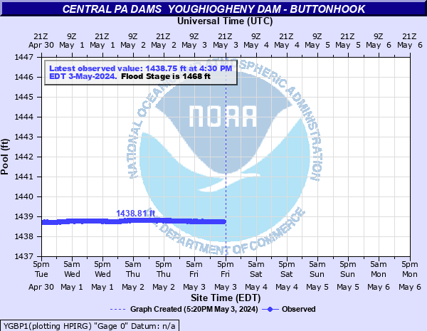
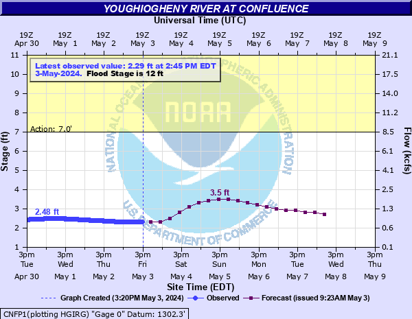
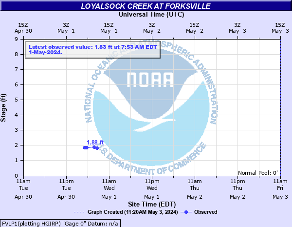
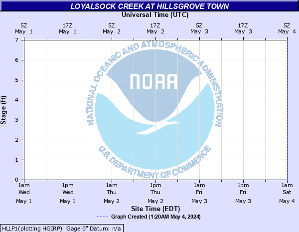
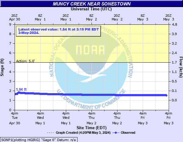
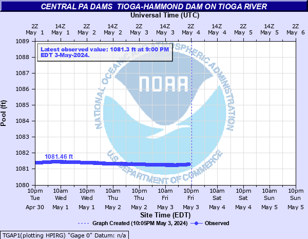
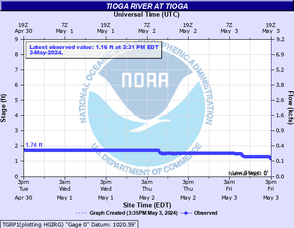
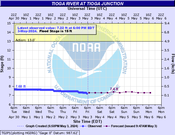
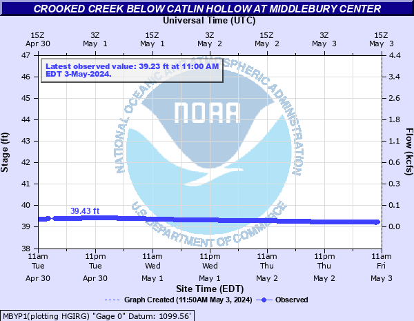
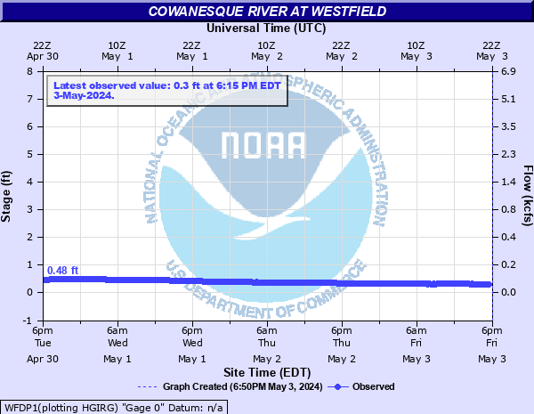
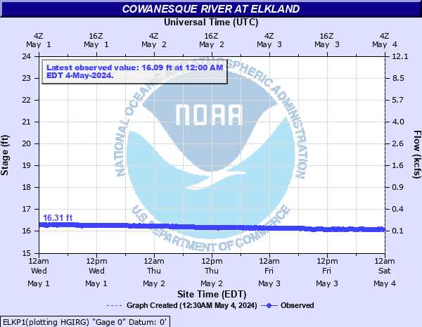
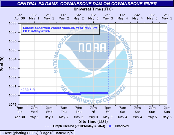
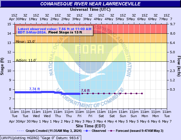
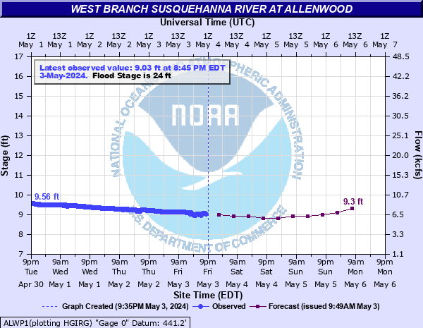
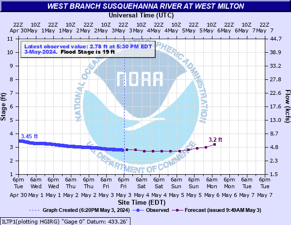
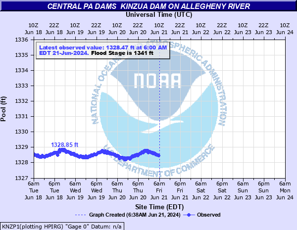
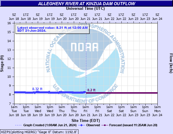
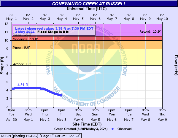
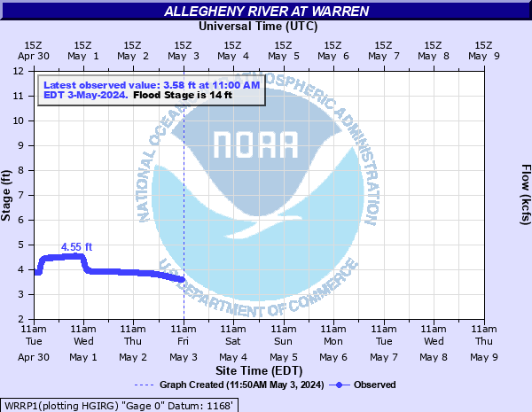
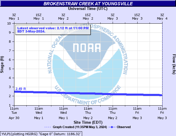
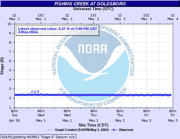
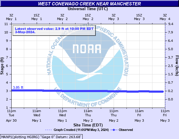
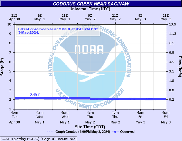
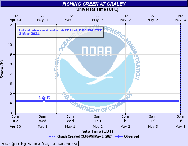
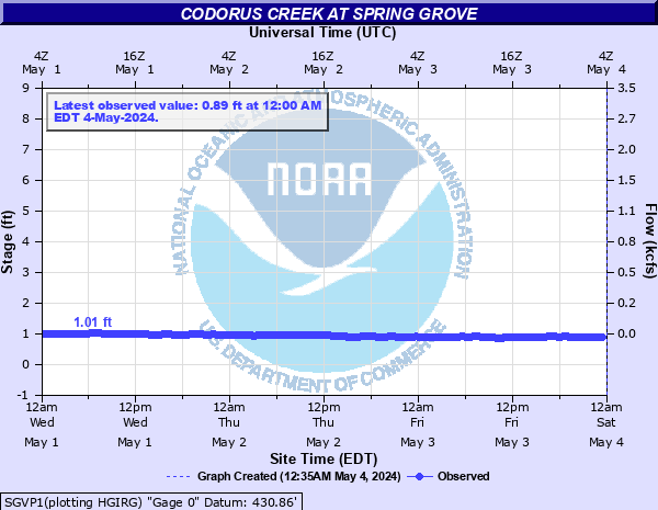
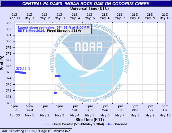
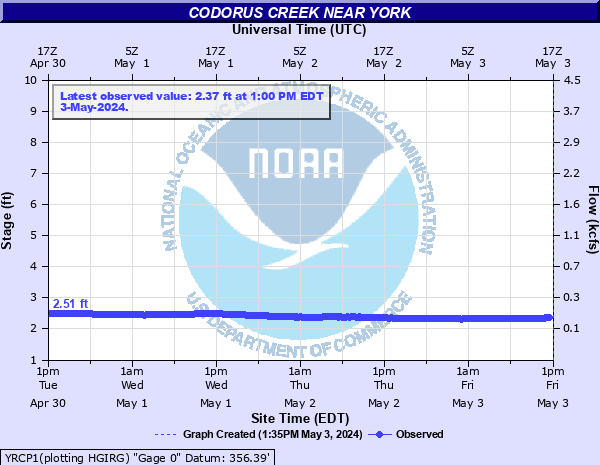
Hydrographs (showing stages and flows over time) are available through the National Water Prediction Service (NWPS) by clicking site names.
|
|||||||||||||||||||||||||||||||||||||||||||||||||||||||||||||||||||||||||||||||||||||||||||||||||||||||||||||||||||||||||||||||||||||||||||||||||||||||||||||||||||||||||||||||||||||||||||||||||||||||||||||||||||||||||||||||||||||||||||||||||||||||||||||||||||||||||||||||||||||||||||||||||||||||||||||||||||||||||||||||||||||||||||||||||||||||||||||||||||||||||||||||||||||||||||||||||||||||||||||||||||||||||||||||||||||||||||||||||||||||||||||||||||||||||||||||||||||||||||||||||||||||||||||||||||||||||||||||||||||||||||||||||||||||||||||||||||||||||||||||||||||||||||||||||||||||||||||||||||||||||||||||||||||||||||||||||||||||||||||||||||||||||||||||||||||||||||||||||||||||||||||||||||||||||||||||||||||||||||||||||||||||||||||||||||||||||||||||||||||||||||||||||||||||||||||||||||||||||||||||||||||||||||||||||||||||||||||||||||||||||||||||||||||||||||||||||||||||||||||||||||||||||||||||||||||||||||||||||||||||||||||||||||||||||||||||||||||||||||||||||||||||||||||||||||||||||||||||||||||||

| Day 1 Severe Weather Outlook | Day 1 Tornado Outlook | Day 1 Severe Wind Outlook | Day 1 Severe Hail Outlook |
|
 |
 |
 |
| SPC Day 1 Outlook Narrative | |||
| Day 2 Severe Weather Outlook | Day 2 Tornado Outlook | Day 2 Severe Wind Outlook | Day 2 Severe Hail Outlook |
 |
 |
 |
 |
| SPC Day 2 Outlook Narrative | |||
| Day 3 Severe Weather Outlook | Day 3 Probability of Severe Weather | ||
 |
 |
||
| SPC Day 3 Outlook Narrative | |||
| Day 4 Severe Weather Outlook | Day 5 Severe Weather Outlook | Day 6 Severe Weather Outlook | Day 7 Severe Weather Outlook | Day 8 Severe Weather Outlook |
 |
 |
 |
 |
 |
| SPC Day 4-8 Outlook Narrative | ||||
 |
Current Watches |
Storm Trend Discussions |
Today's Storm Reports |
Yesterday's Storm Reports |
| Local Storm Reports Text Products | NWS Cleveland, OH | NWS Pittsburgh, PA | NWS State College, PA | NWS Binghamton, NY | NWS Mount Holly, NJ | |||||||||||||||
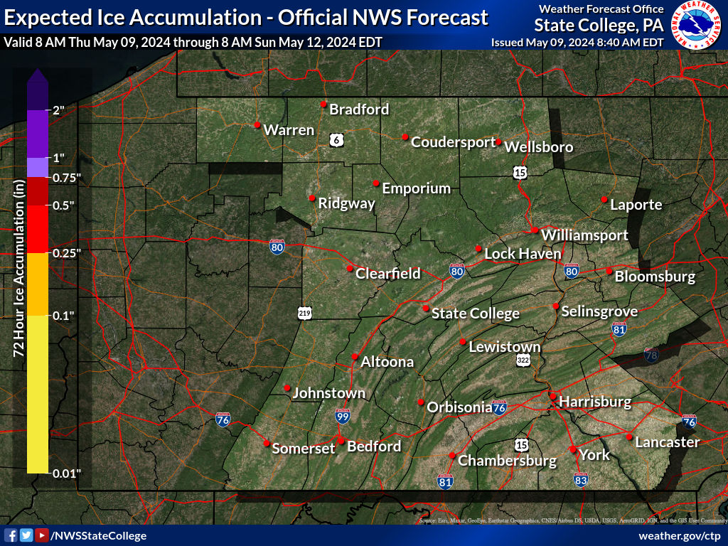
| 72 Hour Snowfall Forecast | 72 Hour Ice Accumulation Forecast | Winter Storm Severity Index | |
 |
 |
|
 |
| 72 Hour Forecast Snow Amounts (12 Hour Periods) | ||||||
| 0 to 12 Hours | 12 to 24 Hours | 24 to 36 Hours | 36 to 48 Hours | 48 to 60 Hours | 60 to 72 Hours | |
 |
 |
 |
 |
 |
 |
|
| 72 Hour Forecast Ice Accumulation (12 Hour Periods) | ||||||
| 0 to 12 Hours | 12 to 24 Hours | 24 to 36 Hours | 36 to 48 Hours | 48 to 60 Hours | 60 to 72 Hours | |
 |
 |
 |
 |
 |
 |
|
| Winter Storm Severity Index Elements | ||||||
| Snow Amount | Snow Load | Blowing Snow | Flash Freeze | Ice Accumulation | Ground Blizzard | |
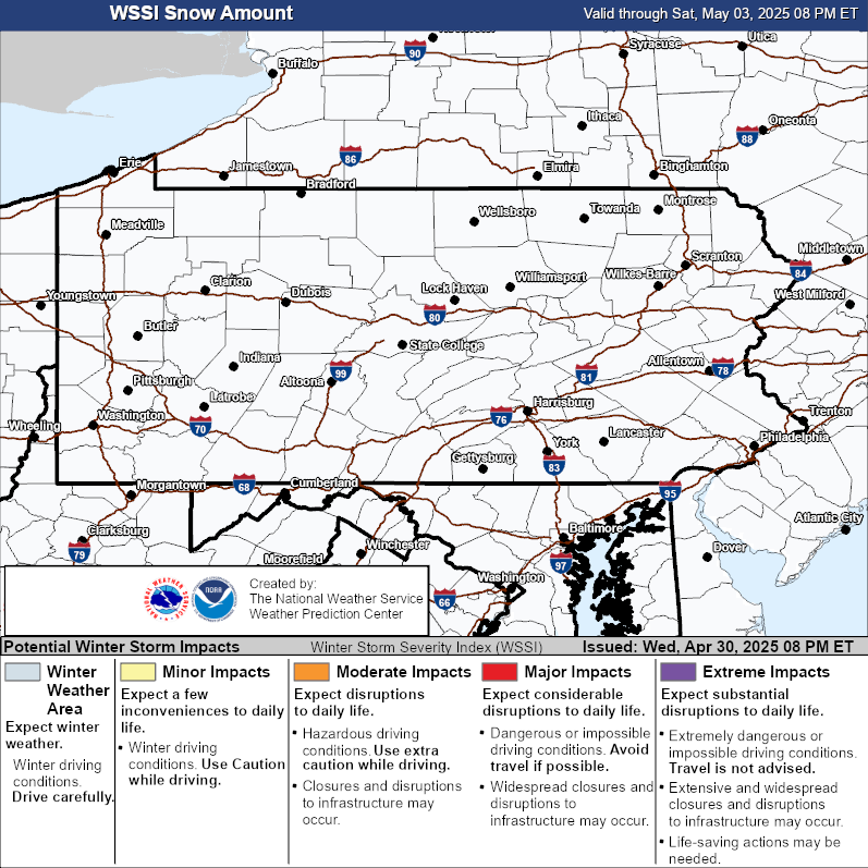 |
 |
 |
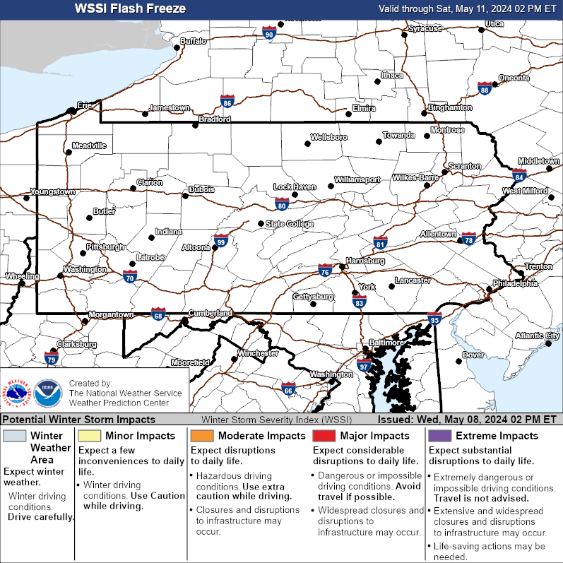 |
 |
 |
|
| Day 1 Snowfall Greater Than 4" | Day 2 Snowfall Greater Than 4" | Day 3 Snowfall Greater Than 4" |
 |
 |
 |
| Day 1 Freezing Rain Greater than 1/4" | Day 2 Freezing Rain Greater than 1/4" | Day 3 Freezing Rain Greater than 1/4" |
 |
 |
 |
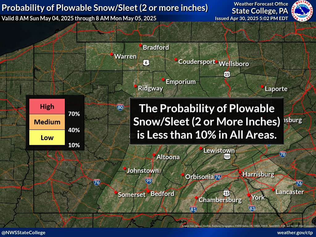
| Day 1 Winter Storm Outlook | Day 2 Winter Storm Outlook | Day 3 Winter Storm Outlook | Day 4 Winter Storm Outlook |
 |
 |
 |
 |
| Day 4 Experimental Winter Weather Outlook | Day 5 Experimental Winter Weather Outlook | Day 6 Experimental Winter Weather Outlook | Day 7 Experimental Winter Weather Outlook |
 |
 |
 |
 |
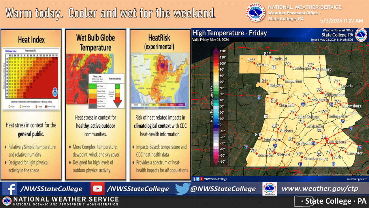
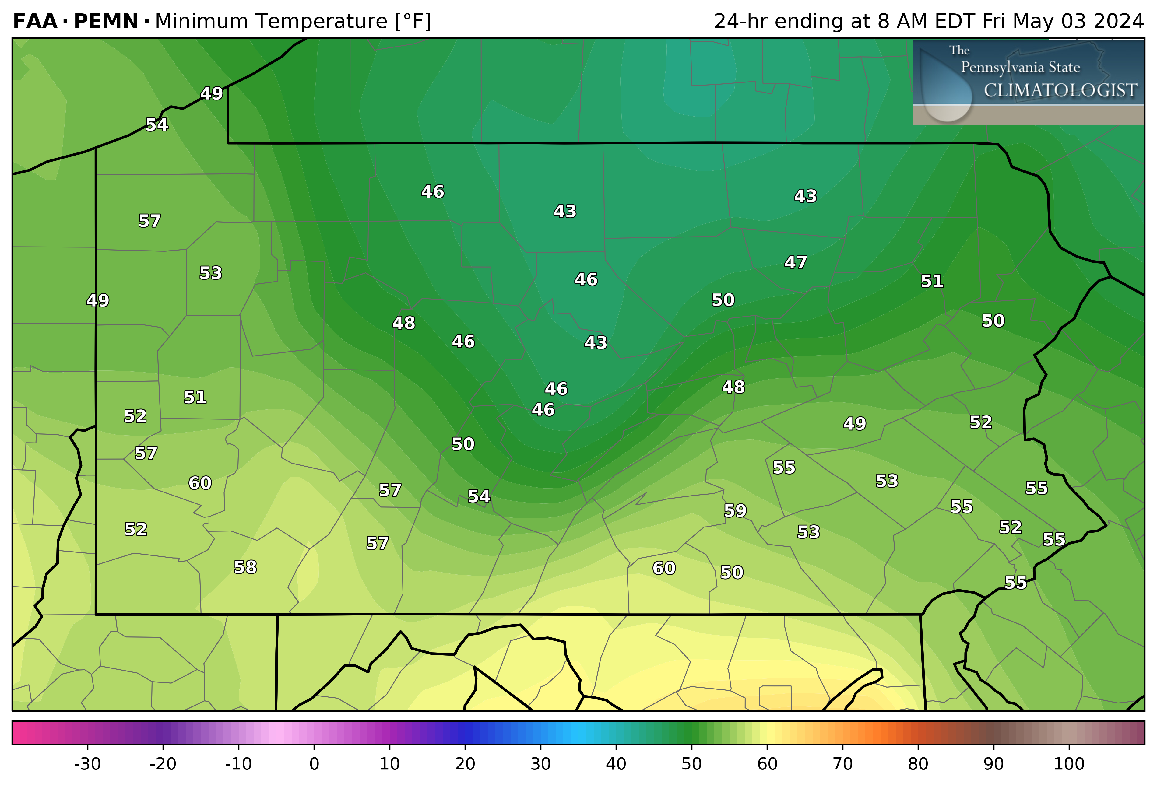
| Observed Minimum Temperature | Observed Maximum Temperature |
 |
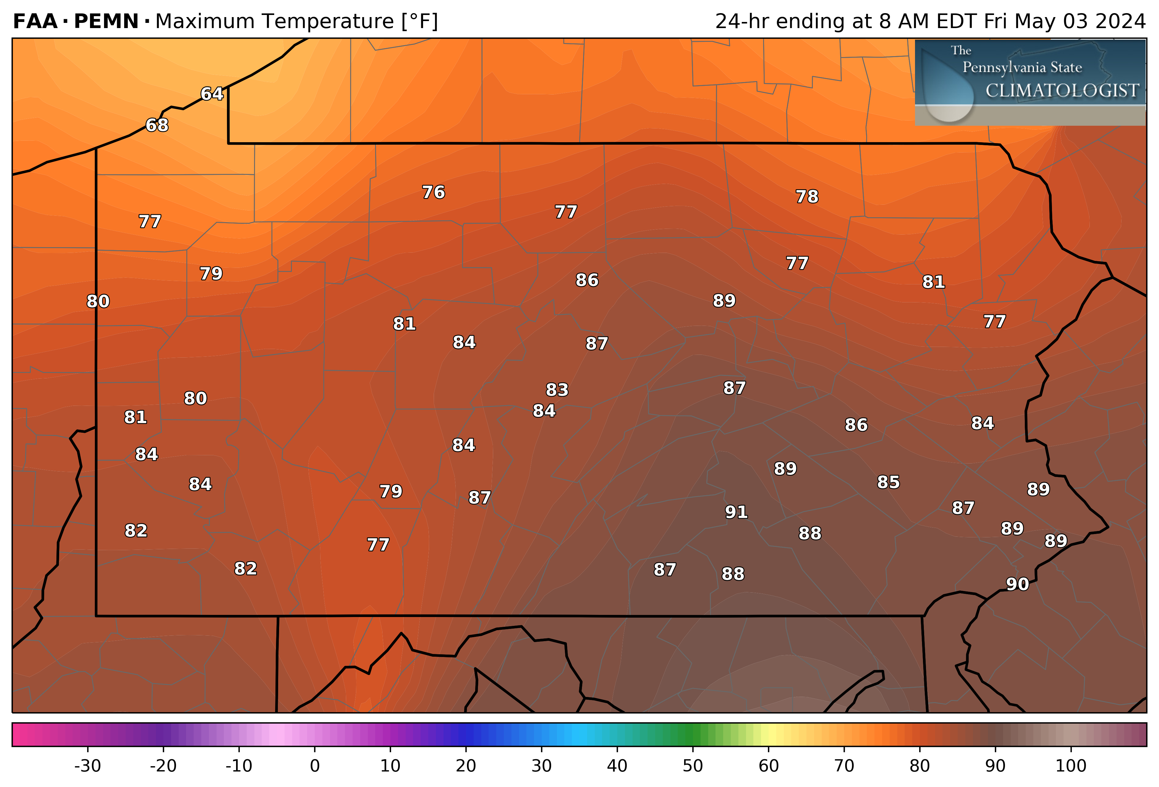 |
| Maps Courtesy of the PA State Climatologist: climate.met.psu.edu | |
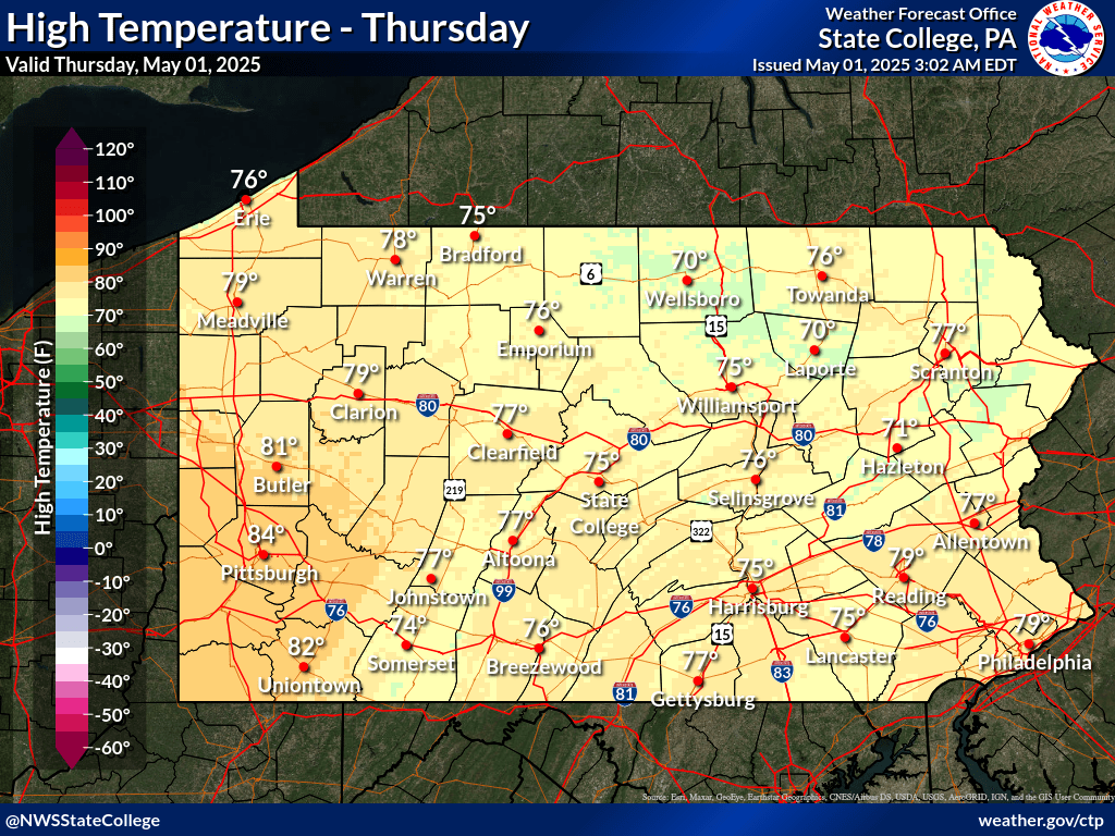
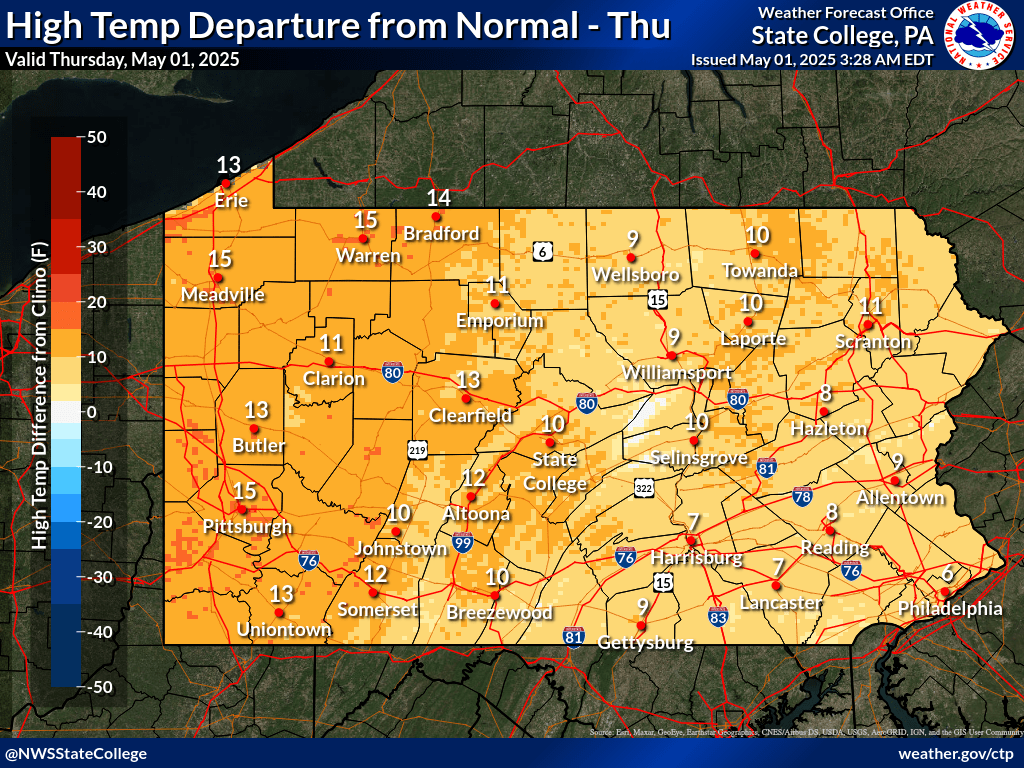
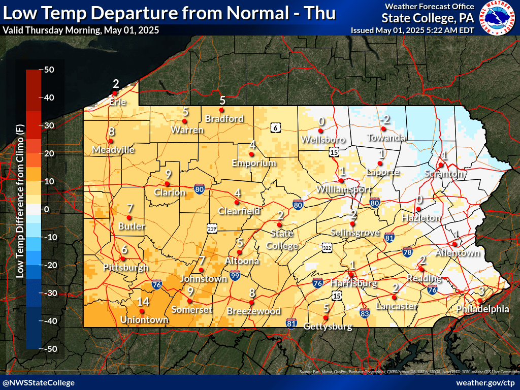
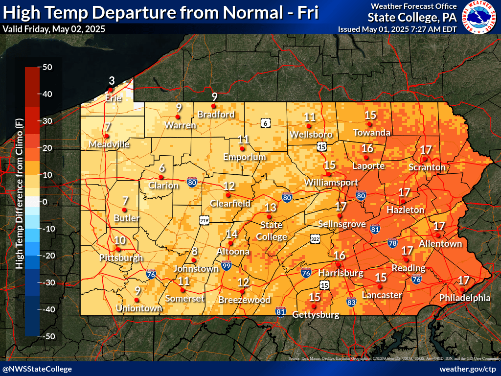
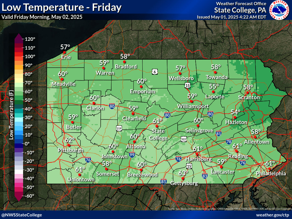
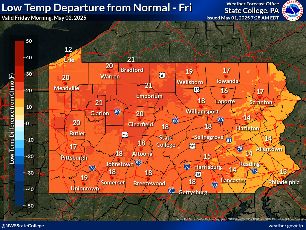
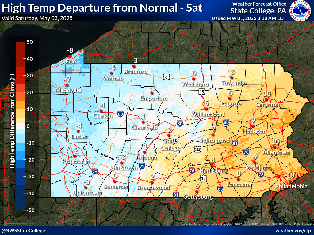
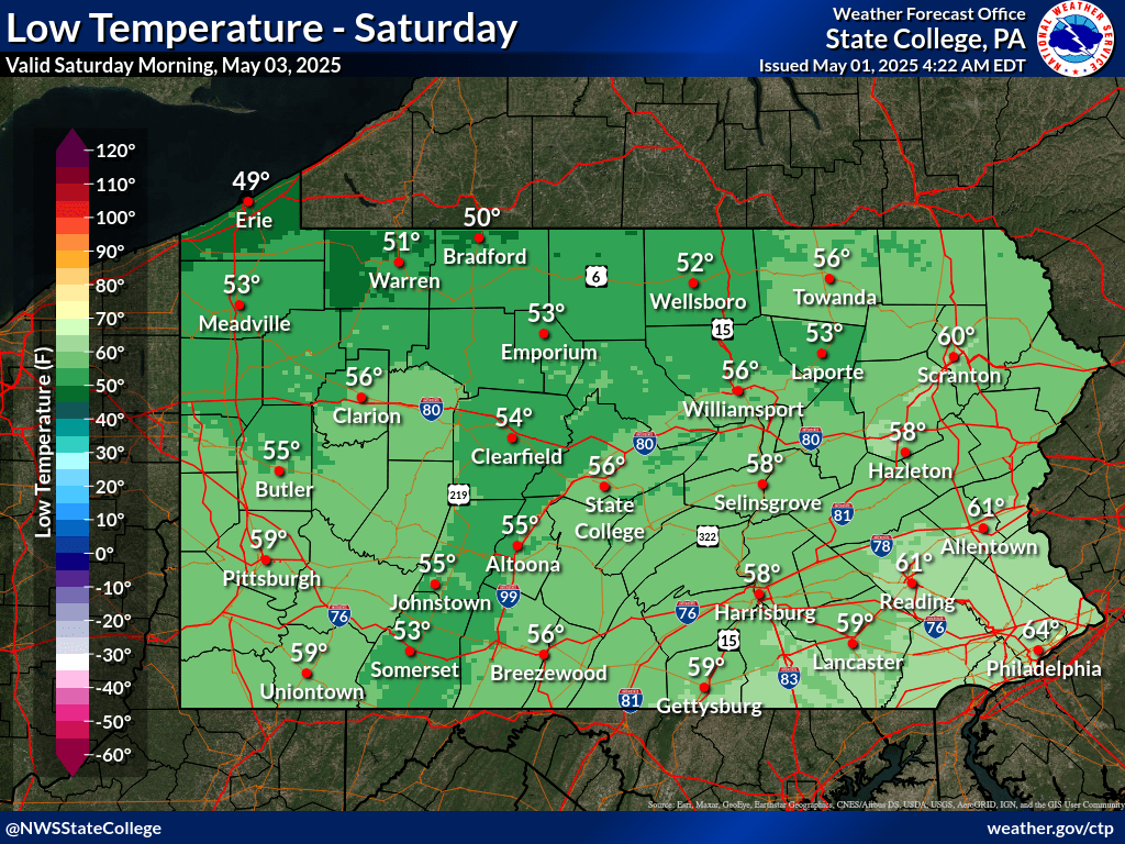
| Today's High Temperatures | Today's High Temperature Departure From Normal | Tonight's Low Temperatures | Tonight's Low Temperature Departure From Normal |
 |
 |
 |
 |
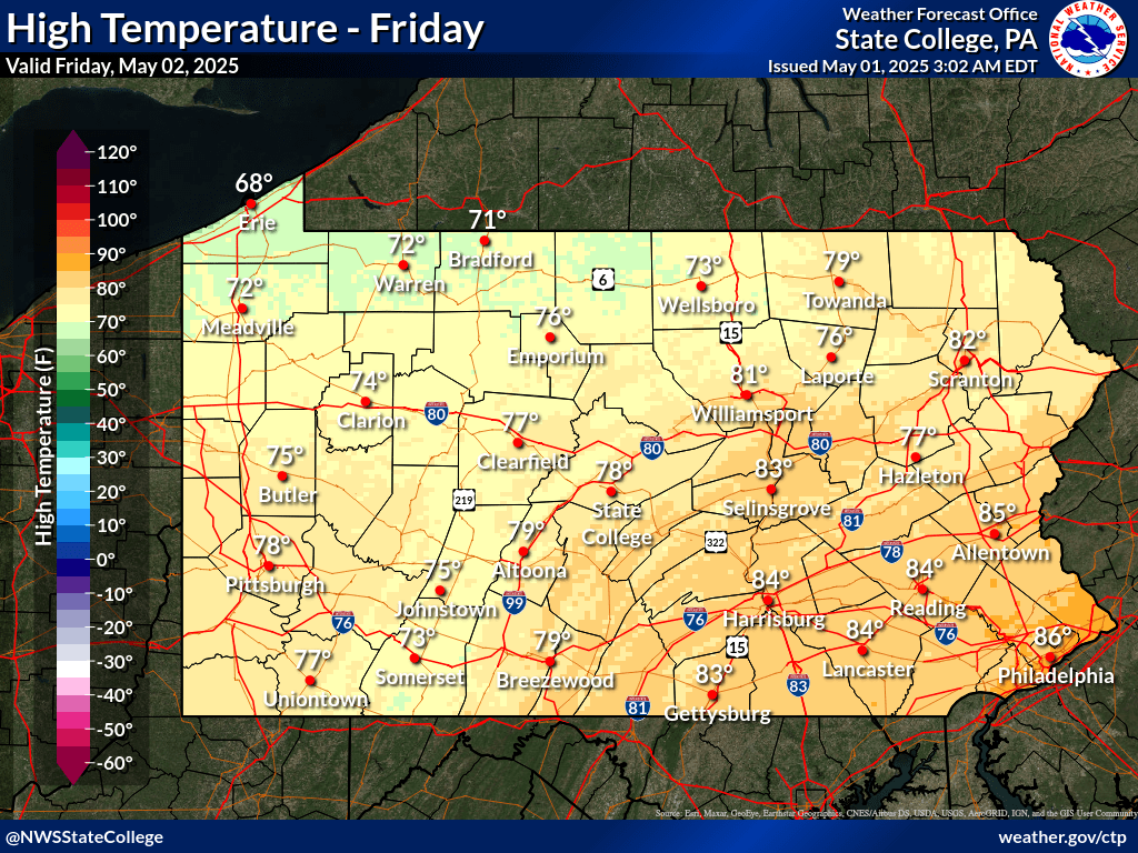
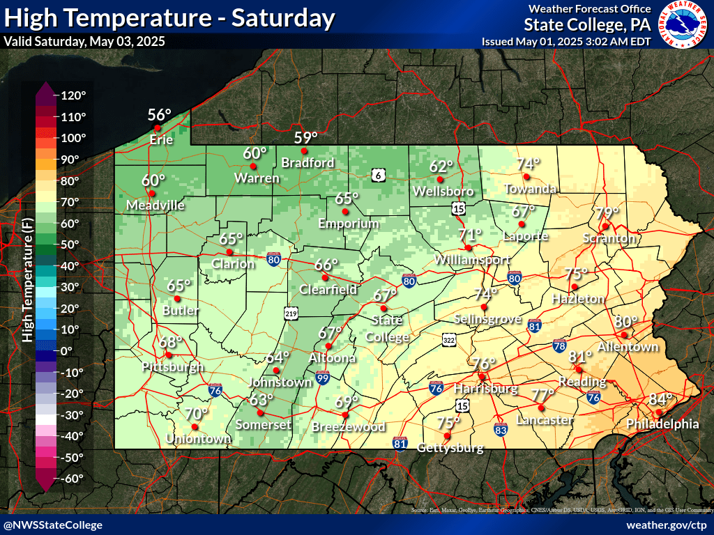
| Tomorrow's High Temperatures | Tomorrow's High Temperature Departure From Normal | Tomorrow Night's Low Temperatures | Tomorrow Night's Low Temperature Departure From Normal |
 |
 |
 |
 |
| Day 3 High Temperatures | Day 3 High Temperature Departure From Normal | Night 3 Low Temperatures | Night 3 Low Temperature Departure From Normal |
 |
 |
 |
 |
| Click Here for Temperature forecasts for the next 7 days | |||
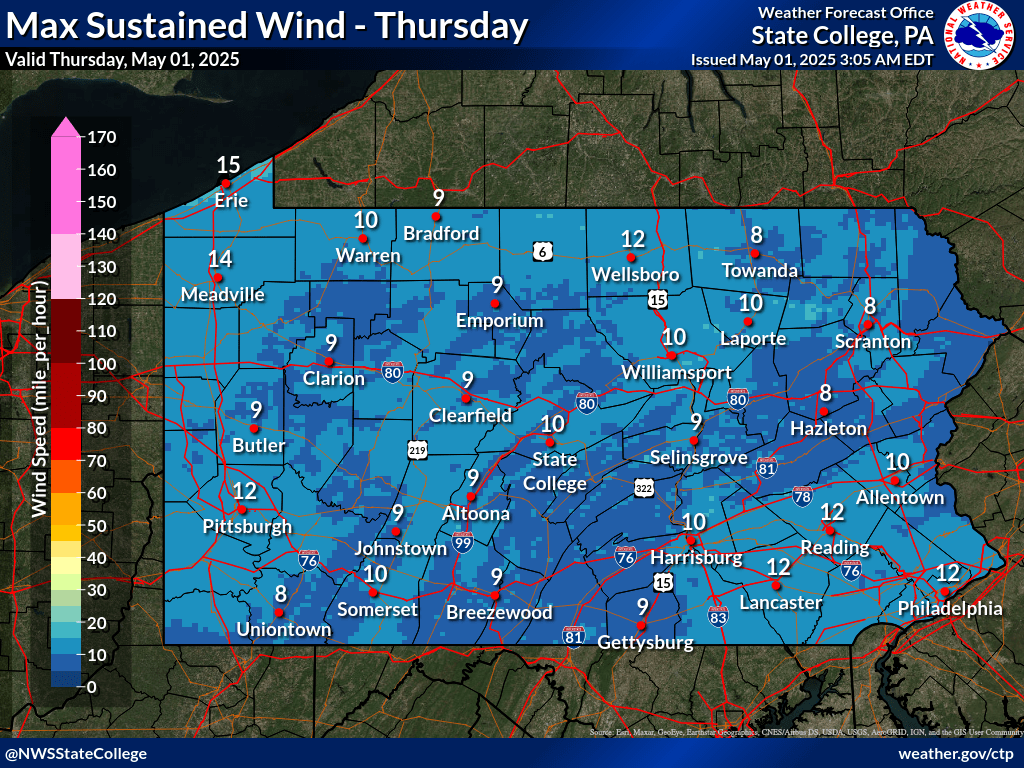
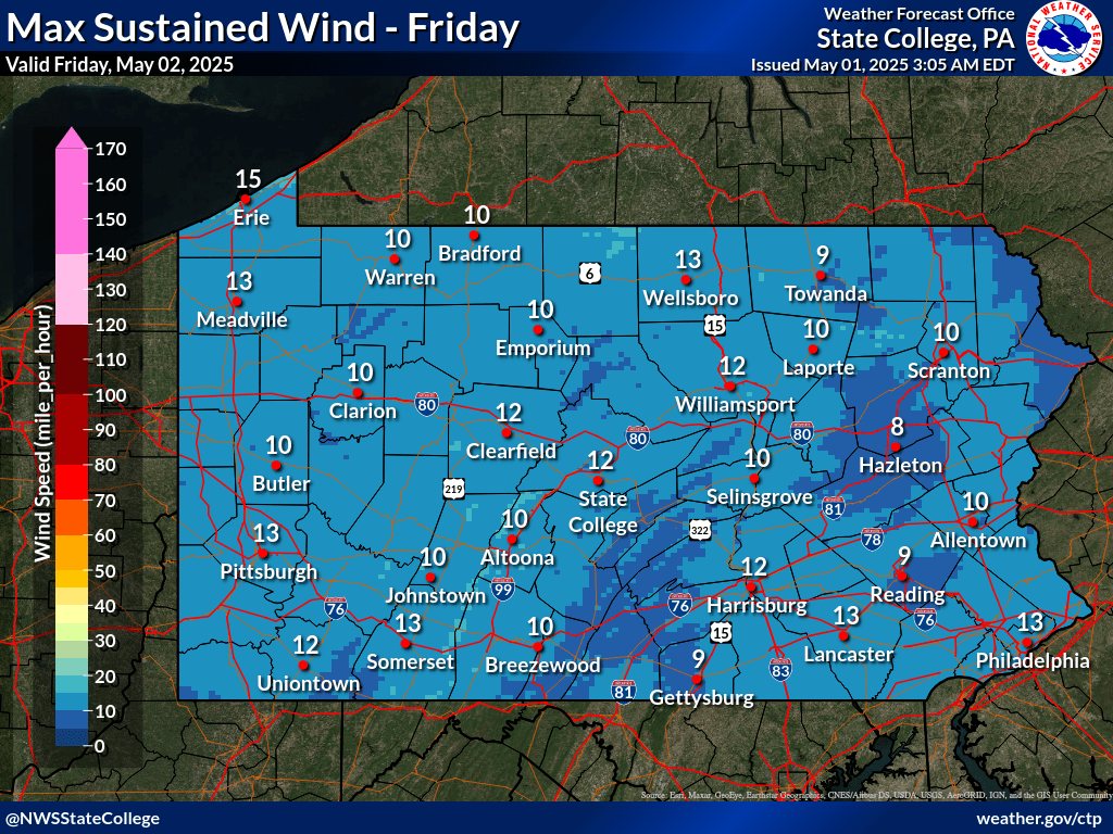
| Today's Maximum Sustained Wind | Tomorrow's Maximum Sustained Wind | Day 3 Maximum Sustained Wind |
 |
 |
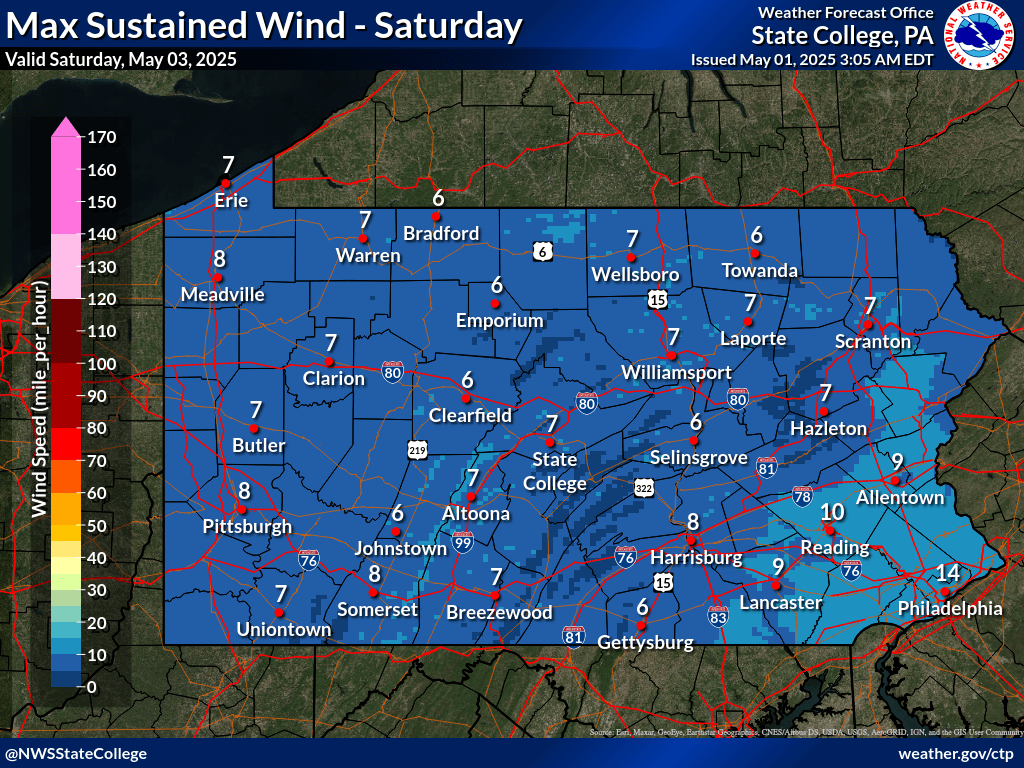 |
| Today's Maximum Wind Gust | Tomorrow's Maximum Wind Gust | Day 3 Maximum Wind Gust |
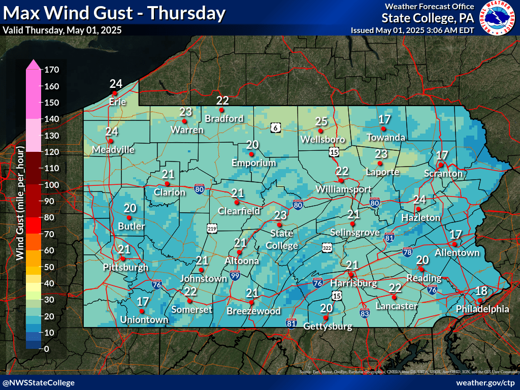 |
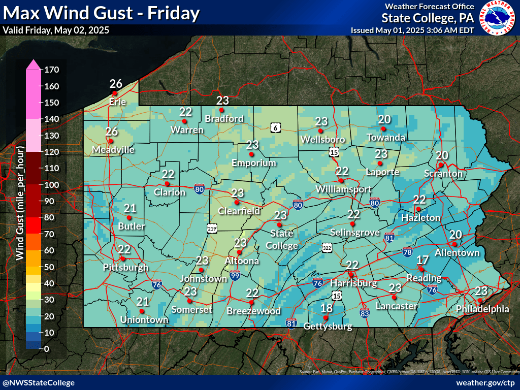 |
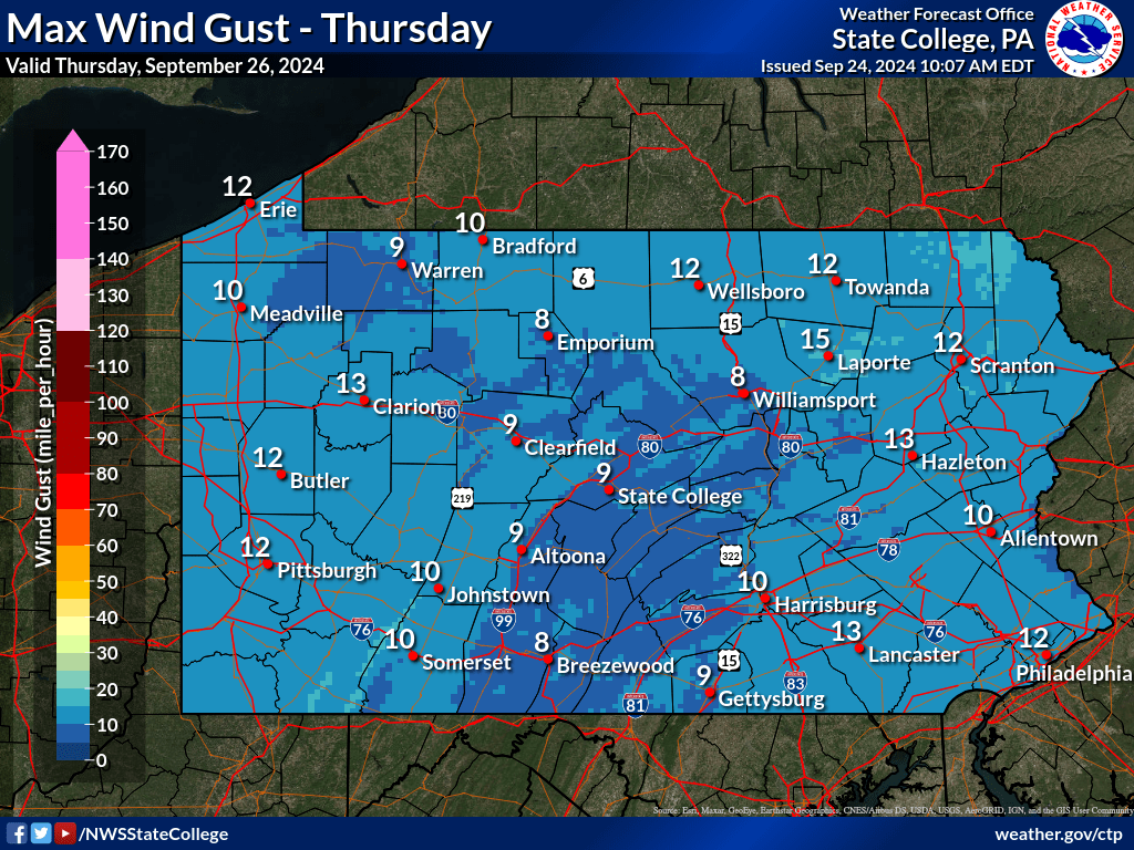 |
| Click Here for Wind forecasts for the next 7 days | ||
| Today's Minimum Wind Chill | Tomorrow's Minimum Wind Chill | Day 3 Minimum Wind Chill |
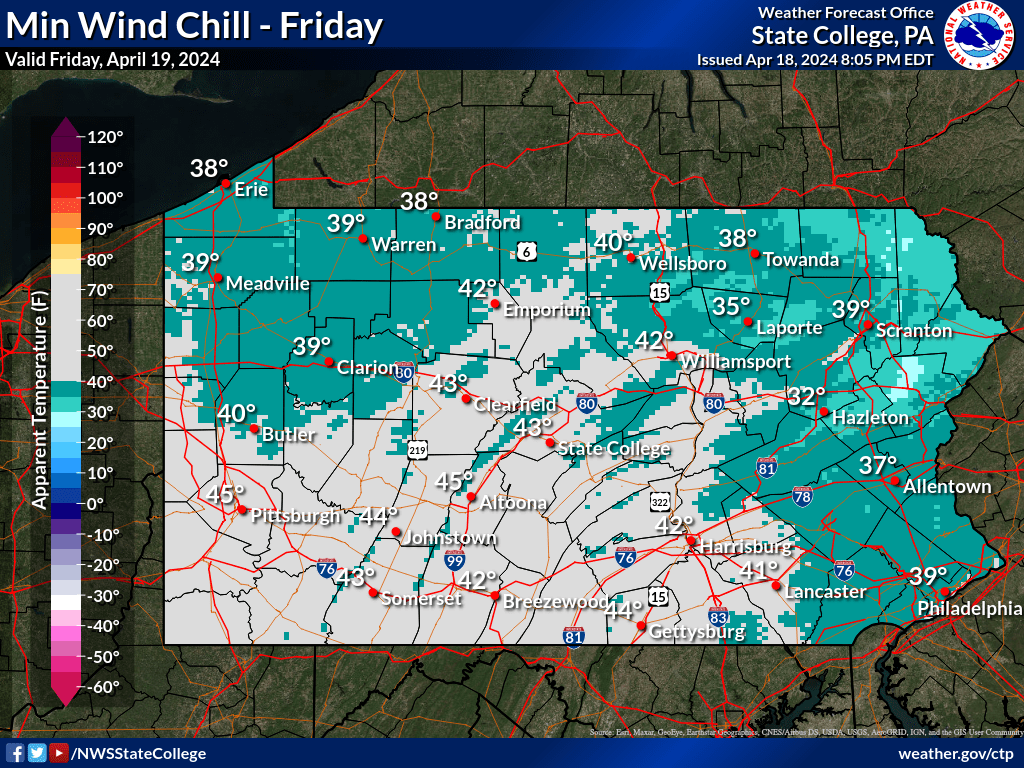 |
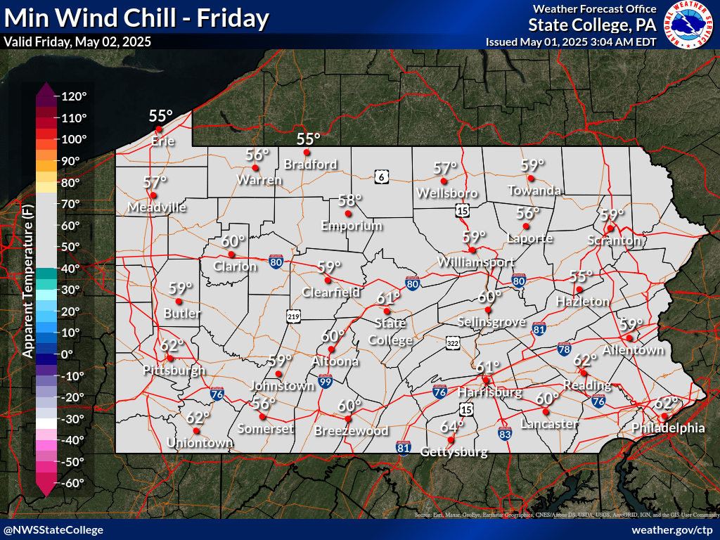 |
 |
| Today's Maximum Heat Index | Tomorrow's Maximum Heat Index | Day 3 Maximum Heat Index |
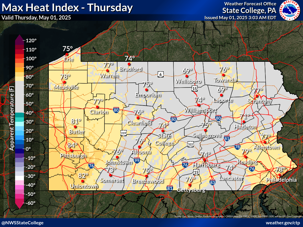 |
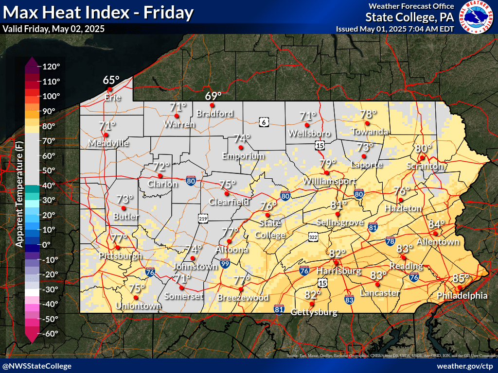 |
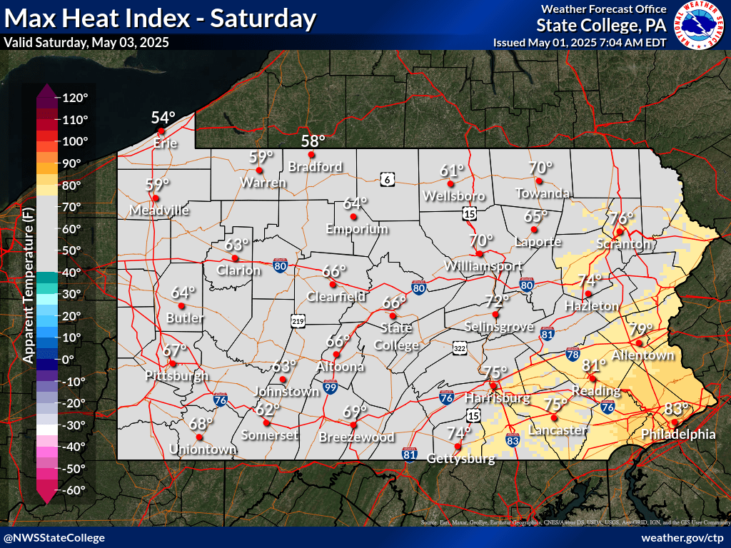 |
| Click Here for Apparent Temperature forecasts for the next 7 days | ||
| Submit Spot Forecast Request | Map View of Active Requests | Calendar View of Active Requests |
| Click to view map on PA DCNR website | Click to view map on PA DCNR website |
| NWS Cleveland, OH | Allegheny National Forest | NWS Binghamton, NY |
| NWS Pittsburgh | NWS State College | NWS Philadelphia/Mount Holly, NJ |
 |
 |
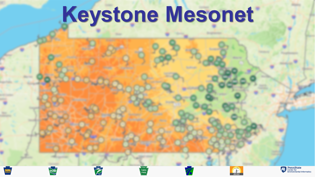
| Click to view Keystone Mesonet Observations | Click to view Dashboard & Enter Location in Search Bar |
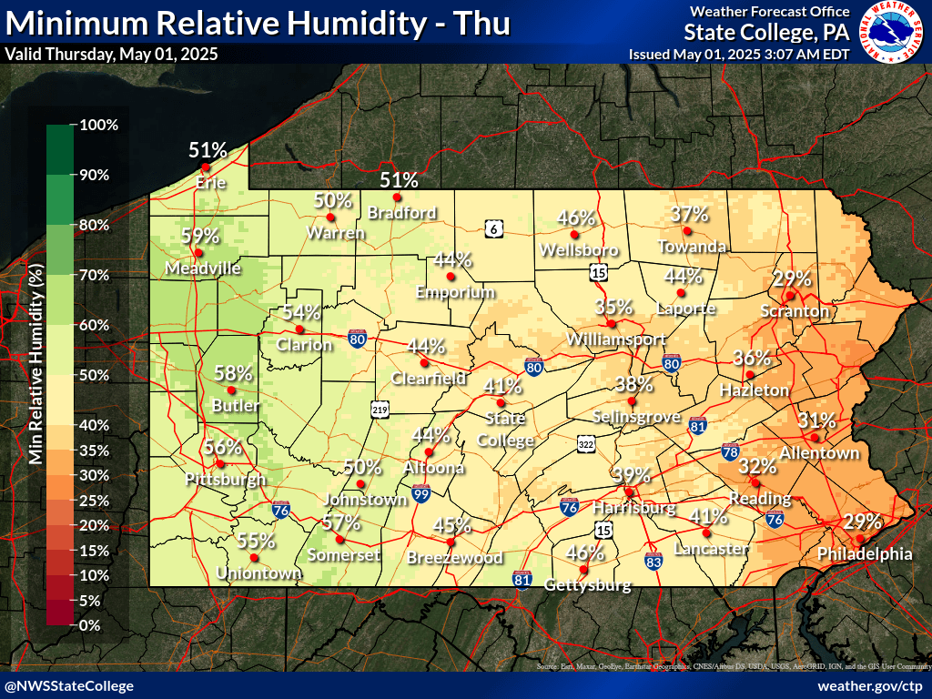
| Day 1 Minimum Relative Humidity | Day 1 Maximum Sustained Wind | Day 1 Maximum Wind Gust |
 |
|
|
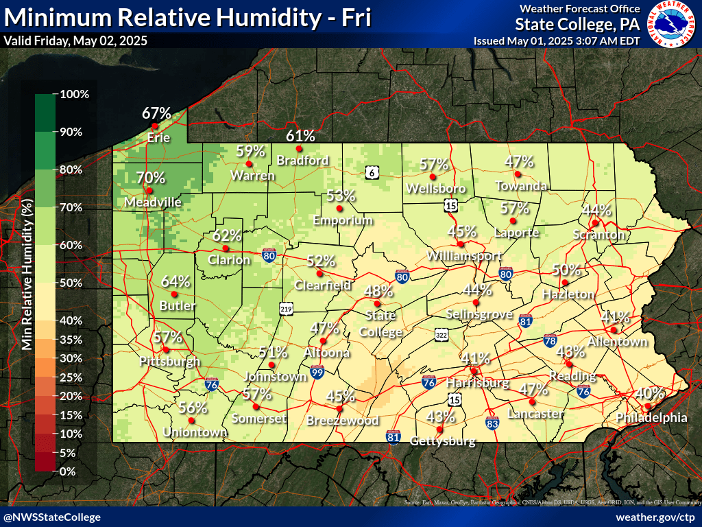
| Tomorrow's Minimum Relative Humidity | Tomorrow's Maximum Sustained Wind | Tomorrow's Maximum Wind Gust |
 |
|
|
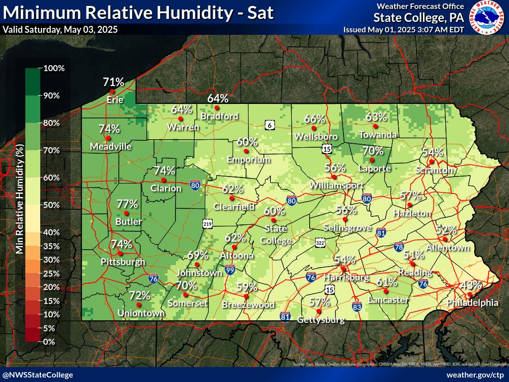
| Day 3 Minimum Relative Humidity | Day 3 Maximum Sustained Wind | Day 3 Maximum Wind Gust |
 |
|
|
| Click here for RH, Wind, and Wind Gust forecasts for the next 7 days | ||
Haines Index (Lower Atmospheric Stability) |
WFAS Observed Fire Danger Rating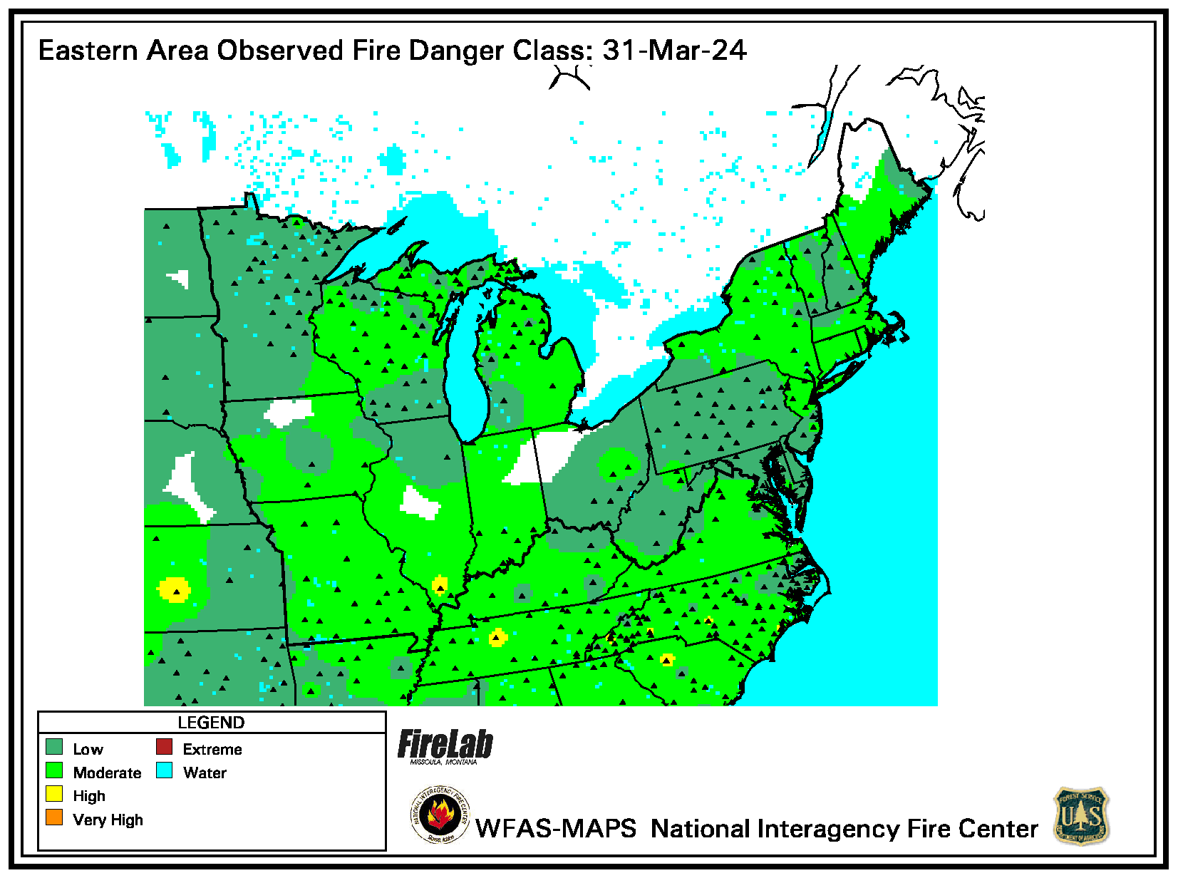 |
WFAS Forecast Fire Danger Rating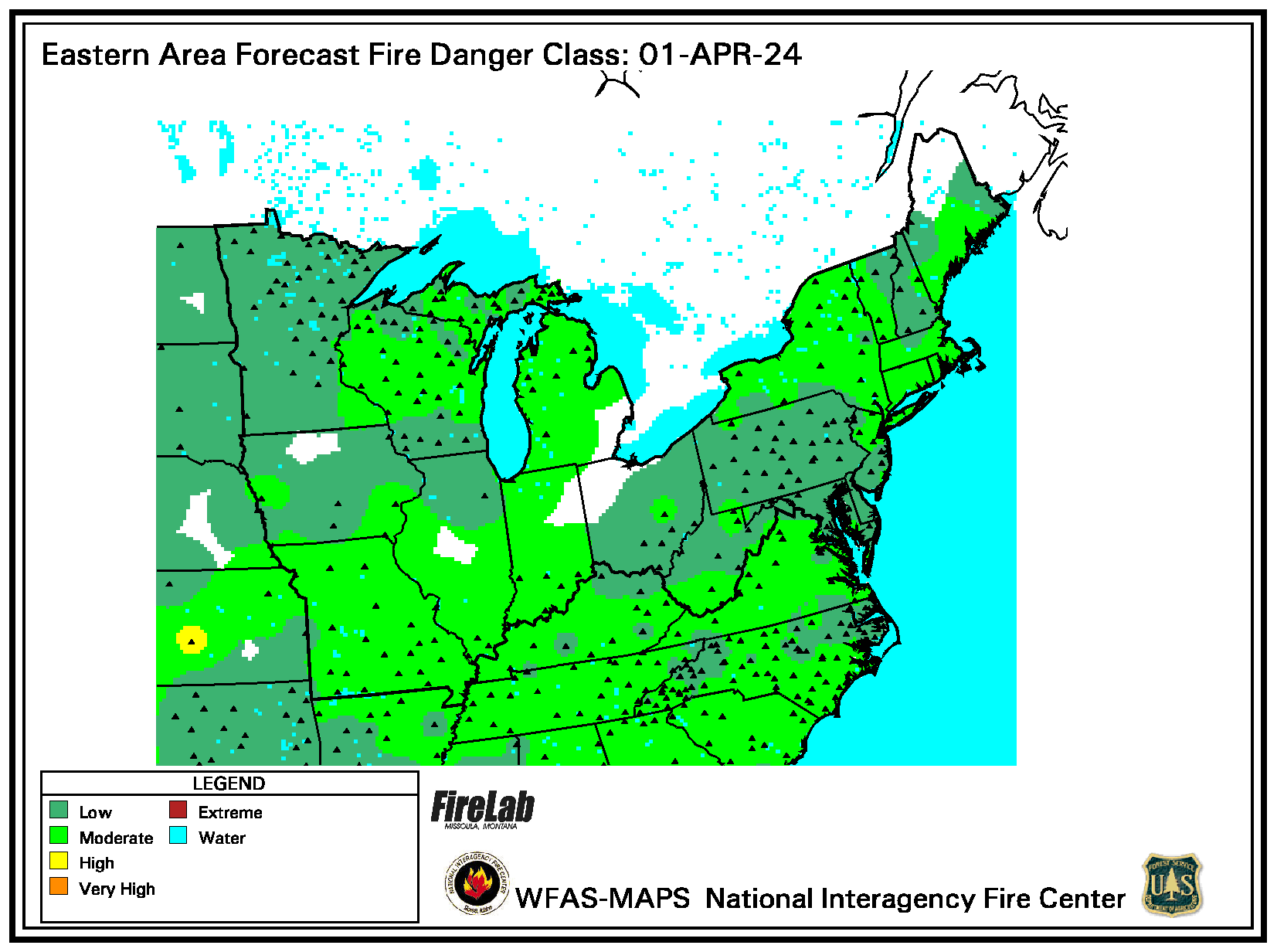 |
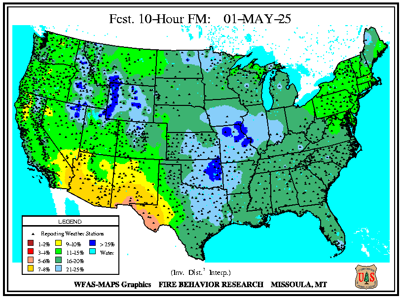
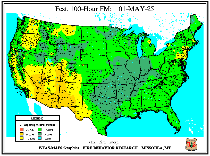
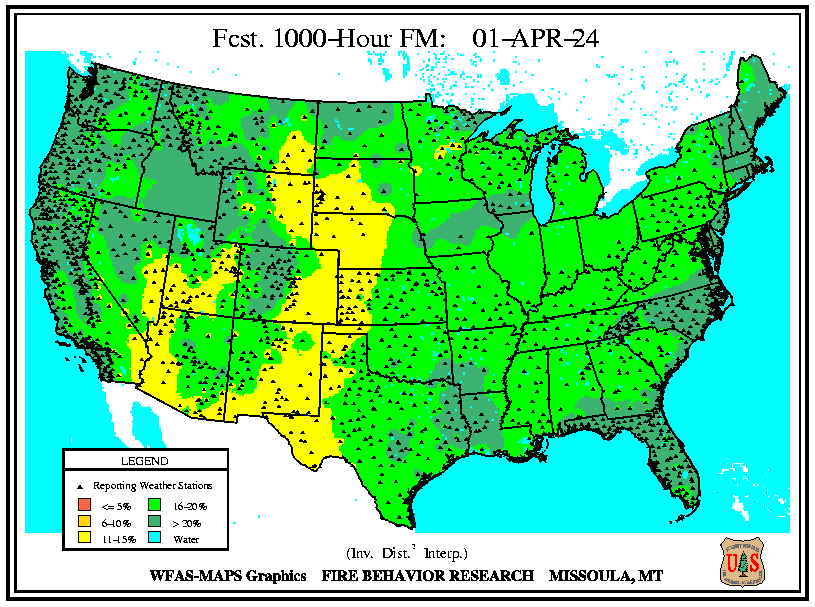
| Observed 10 Hour Fuels | Observed 100 Hour Fuels | Observed 1000 Hour Fuels |
 |
 |
 |
| Click here for a map of Observed Fire Danger from PA DCNR | ||
| Forecast 10 Hour Fuels | Forecast 100 Hour Fuels | Forecast 1000 Hour Fuels |
 |
 |
 |
| Click here for a map of Forecast Fire Danger from PA DCNR | ||
| SPC Fire Weather Day 1 Outlook | SPC Fire Weather Day 2 Outlook | SPC Fire Weather Day 3-8 Outlook |
 |
 |
 |
| Click here to view Fire Weather Outlook maps for Pennsylvania for the next 8 days | ||
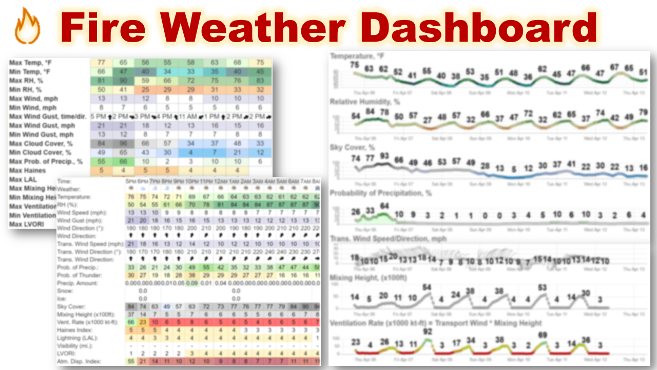
| Map of PA RAWS Sites from MesoWest* |
|
| *Note that MesoWest links may not work at first. Copy and paste into new tab/window to view. |
| NWS State College | NWS Binghamton, NY |
| NWS Pittsburgh | NWS Philadelphia/Mount Holly, NJ |
 |
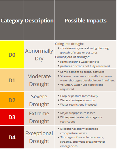 |
| Seasonal Drought Outlook | Palmer Drought Severity Index |
 |
 |
 |
 |
| Click Here for The Tropical Weather Outlook Discussion | |
| 2023 | 2024 | 2025 | 2026 | 2027 |
|---|---|---|---|---|
| Arlene (ar-LEEN) | Alberto (al-BAIR-toe) | Andrea (AN-dree uh) | Arthur (AR-thur) | Ana (AH-nah) |
| Bret (bret) | Beryl (BEHR-ril) | Barry (BAIR-ree) | Bertha (BUR-thuh) | Bill (bill) |
| Cindy (SIN-dee) | Chris (kris) | Chantal(shahn-TAHL) | Cristobal (krees-TOH-bahl) | Claudette (klaw-DET) |
| Don (dahn) | Debby (DEH-bee) | Dexter (DEHK-ster) | Dolly (DAH-lee) | Danny (DAN-ee) |
| Emily (EH-mih-lee) | Ernesto (er-NES-toh) | Erin (AIR-rin) | Edouard (eh-DWARD) | Elsa (EL-suh) |
| Franklin (FRANK-lin) | Francine (fran-SEEN) | Fernand (fair-NAHN) | Fay (fay) | Fred (frehd) |
| Gert (gert) | Gordon (GOR-duhn) | Gabrielle (ga-bree-ELL) | Gonzalo (gohn- SAH-loh) | Grace (grayss) |
| Harold (HAIR-uld) | Helene (heh-LEEN) | Humberto (oom-BAIR-toh) | Hanna (HAN-uh) | Henri (ahn-REE) |
| Idalia (ee-DAL-ya) | Isaac (EYE-zik) | Imelda (ee-MEHL-dah) | Isaias (ees-ah-EE-ahs) | Imani (ee-MAH-nee) |
| Jose (ho-ZAY) | Joyce (joyss) | Jerry (JEHR-ee) | Josephine (JOH-seh-feen) | Julian (JOO-lee-uhn) |
| Katia (KAH-tyah) | Kirk (kurk) | Karen (KAIR-ren) | Kyle (KY-ull) | Kate (kayt) |
| Lee (lee) | Leslie (LEHZ-lee) | Lorenzo (loh-REN-zoh) | Leah (LEE-ah) | Larry (LAIR-ree) |
| Margot (MAR-go) | Milton (MIL-ton) | Melissa (meh-LIH-suh) | Marco (MAR-koe) | Mindy (MIN-dee) |
| Nigel (NY-juhl) | Nadine (nay-DEEN) | Nestor (NES-tor) | Nana (NA-na) | Nicholas (NIH-kuh-luss) |
| Ophelia (o-FEEL-ya) | Oscar (AHS-kur) | Olga (OAL-guh) | Omar (OH-mar) | Odette (oh-DEHT) |
| Philippe (fee-LEEP) | Patty (PAT-ee) | Pablo (PAHB-lo) | Paulette (pawl-LET) | Peter (PEE-tur) |
| Rina (REE-nuh) | Rafael (rah-fah--ELL) | Rebekah (reh-BEH-kuh) | Rene (re-NAY) | Rose (rohz) |
| Sean (shawn) | Sara (SAIR-uh) | Sebastien (sus-BASH-chuhn) | Sally (SAL-ee) | Sam (sam) |
| Tammy (TAM-ee) | Tony (TOH-nee) | Tanya (TAHN-yuh) | Teddy (TEHD-ee) | Teresa (tuh-REE-suh) |
| Vince (vinss) | Valerie (VAH-lur-ee) | Van (van) | Vicky (VIH-kee) | Victor (VIK-tur) |
| Whitney (WHIT-nee) | William (WILL-yum) | Wendy (WEN-dee) | Wilfred (WILL-fred) | Wanda (WAHN-duh) |
| Space Weather Overview | Aurora Forecast |
 |
 |
| Click Here for the 3-day Geomagnetic Forecast | |
| Days 3-7 Hazards Outlook (WPC) |
 |
| Days 8-14 Hazards Outlook (CPC) | Days 8-14 Risk of Hazardous Temperatures (CPC) | Days 8-14 Risk of Heavy Precipitation (CPC) |
 |
 |
 |
| 6-10 Day Temperature Outlook (CPC) | 6-10 Day Precipitation Outlook (CPC) |
 |
 |
| 8-14 Day Temperature Outlook (CPC) | 8-14 Day Precipitation Outlook (CPC) |
 |
 |
| **Experimental** Week 3-4 Temperature Outlook (CPC) | **Experimental** Week 3-4 Precipitation Outlook (CPC) |
 |
 |
| One Month Temperature Outlook (CPC) | One Month Precipitation Outlook (CPC) |
 |
 |
| Three Month Temperature Outlook (CPC) | Three Month Precipitation Outlook (CPC) |
 |
 |
For Detailed Weather Information
|
 |
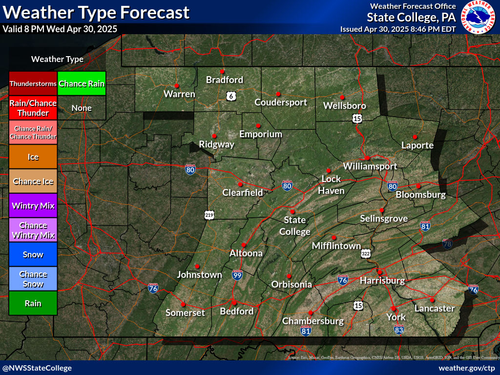
| Weather Type and Coverage Forecast |
**Prototype Under Development** **Not to be relied on for operational decision making**
|


 Send Us a Report