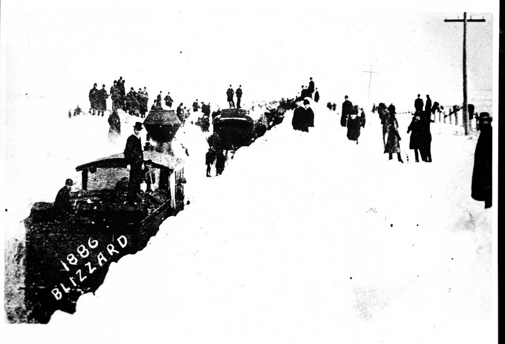
B-B-Blizzard!
The January 1886 Blizzards -- 138 Years Later
Two great blizzards hit western Kansas the first week of January 1886. The first blizzard began on the 1st around noon at Dodge City and continued until the early morning hours of the 3rd. During this time, seven and a half inches of snow fell (Although it could be argued that much more than that fell based on "melted snow" observations that were taken. See meteorological discussion below) and wind speeds averaged 20 to 30 mph from the north to northwest. The lowest temperature was 12 °F on the 3rd. A second, more severe blizzard followed on the 6th and 7th and was accompanied by Arctic air that sent temperatures plummeting to well below zero. Even though only two inches of snow fell, the wind combined with the brutally cold air made this one of the coldest periods on record. The temperature did not rise above 10°F at Dodge City until the 11th. The coldest temperature was 16°F below zero on the 8th.
There was no advance warning for the cold wave and 2nd blizzard that hit on the night of the 6th. The Chief Signal Office sent a notification for a cold wave. However, because of the conditions, the telegraph office in Dodge City did not receive it until the storm came to an end. It is not clear how many more cattle were lost across Kansas during this time. It was estimated that 75-80 percent of cattle had been killed in some counties. What is known is that this was the worst natural disaster for the entire stateof Kansas. There was a livestock fence north of the Union Pacific railroad tracks in northern Kansas. Cattle would drift south with the storms and eventually wound up dying of starvation and exhaustion along the fence. It was said that a man could walk along the fence over bones all the way to eastern Colorado. South of the railroad, cattle would march south until they ended up falling into ravines or small canyons. Other cattle would follow and eventually would wind up on top of the cattle in the ravine. The cattle would die by smothering, starvation or freezing. There was also a newspaper account of cattle trains headed east across Kansas. The trains were rushed to Dodge City which was a feeding station at the time for cattle. The next morning less than 25 percent of the cattle that were unloaded were alive. Cattle also died tried trying to cross the Arkansas River, creeks and water holes. A man who came in to Dodge City from his ranch told of seeing cattle standing on their feet, frozen! The blizzard and Arctic air mass also affected the southern plains. Cattle had drifted several hundred miles south into northern Mexico. Dead carcasses were seen on the plains along with dead antelope and even wolves.
Another newspaper account told the story of a rancher who was offered $25,000 for his cattle before the storms hit. After the blizzards, he sold the remnants of his cattle for $500. There was a ranch in southwestern Kansas with 5,500 cattle before the storm and only 500 survived. Not even the hides could be saved from the cattle that perished. The result from the blizzards was the most unprecedented loss of livestock ever experienced on the plains.
The Blizzards of 1886 also took a heavy toll on human life. Estimates were that as many as 30 people died in western Kansas from the blizzards. There was also another account of 35 people dying in Thomas County. As many as 50 to 100 people had died across the entire state of Kansas. Townspeople fared well as compared to settlers out in the prairie. There were several instances where people were found frozen to death in their dugouts and shanties. Other people were found on the prairie dead. There are several heartbreaking stories on how some of the people died. Two young ladies froze to death near Minneola in Clark County. They were out walking, trying to reach their brothers’ house for shelter from the blizzard. They had left their house, which was filling up with snow, with their mother. In the end, all three were located the next morning huddled together. The two young women died, but their mother was still alive with badly frozen feet. A homesteader and his team of two horses caught out in the blizzard in northwest Kansas. They froze to death within fifty feet of the man’s dugout. A farmer with his wife and six children were found frozen to death outside of Oberlin. Jack rabbits and birds of every species were found frozen to death across the prairie. Snow depths were not that deep, but there were some drifts that were up to ten feet high in places.
All the railroads in Kansas were completely paralyzed. Trains were stalled and it was very difficult to clear the tracks. After several days, the tracks were finally cleared. A passenger train was stopped in western Kansas by an obstruction ahead of it. Snow began to drift around the wheels and it became stuck. The snow had drifted up to the windows of the train. Several days later when the snow was removed, the wheels were found frozen to the rail. The rail cars had to be unbuckled and broken loose one at a time.
There have been other blizzards since January 1886 that have been just as bad. As a result of this great blizzard and the consequences that resulted, changes were made in preparation for the winter months to help prevent livestock losses. First, more fences were put up by ranchers to keep the cattle from drifting onto the open prairie. Second, more provisions were made available for the livestock prior to the cold months. Third, The Weather Bureau (currently The National Weather Service) made advances in better dissemination of storm warnings. Finally, the railroad companies acquired a modern rotary snowplow to help remove the deepest of snowdrifts.
Reconstructing the 1886 Blizzards -- Meteorological Discussion
An exciting new dataset has emerged that allows meteorologists and other climate and weather researchers to fulfill and uncover some of the curiosity and questions that exist regarding high-impact historical weather events dating back to the early 20th century and now even the late 19th century! This dataset, known as the 20th Century Reanalysis Project, takes historical global surface pressure data and reconstructs a myriad of tropospheric variables such as pressure/height, temperature, wind, and moisture. Advancements in computing technology and ensemble filter modeling techniques have allowed such accurate reconstruction of the atmosphere to be produced using only surface pressure data! Version 1 of the dataset extended back to 1908, and the recent emergence of Version 2 formerly extended back to 1891. Just in the last year, Version 2 of the dataset extended back to 1871, which now provides us the opportunity to take a deeper meteorological look at the 1886 blizzards.
The 20th Century Reanalysis dataset was analyzed for the dates January 1 through January 10, 1886, using Unidata's Integrated Data Viewer display software. What follows below are a series of figures of upper air and surface patterns leading up to and during these storms. To complete this analysis, a time-series of 8-hourly observations recorded at Dodge City during both blizzards are graphed. Finally, several cropped daily U.S. Signal Office weather maps are also shown to compare that analysis with the 20th Century Reanalysis.
The First Blizzard -- January 1-3
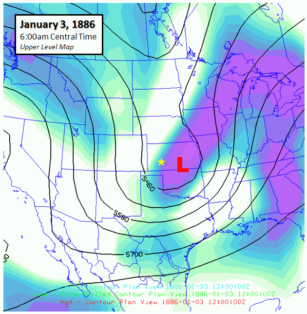
The first of the two blizzard to impact Dodge City (and pretty much all of western and central Kansas for that matter), commenced during the afternoon hours of January 1. The reanalysis dataset suggests that a classic Southwest Low was in the formative stages late on the 1st. It was a slow developing system, and even though light snow was recorded on the 1st, only 0.04" of melted snow was measured at Dodge City through 10:00pm. During the overnight hours of the 1st going into January 2nd, the storm really began to take shape as it was entering Texas. By 6:00am January 2, an upper low was probably centered somewhere between central New Mexico and the TX-NM border. The reanalysis data showed a mean surface low position around the Red River area north of Dallas, TX. The isobars from the reanalysis data match the U.S. Signal Office observational analysis very closely. See the series of figures below:
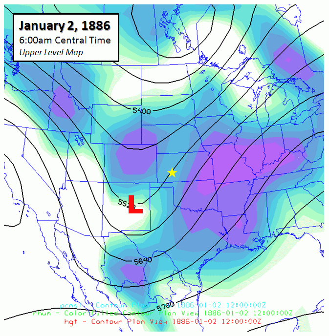
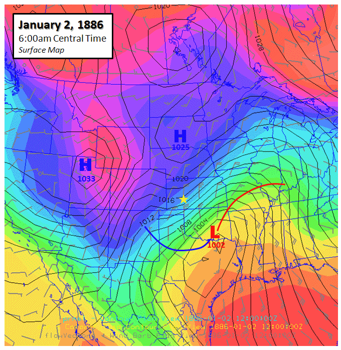
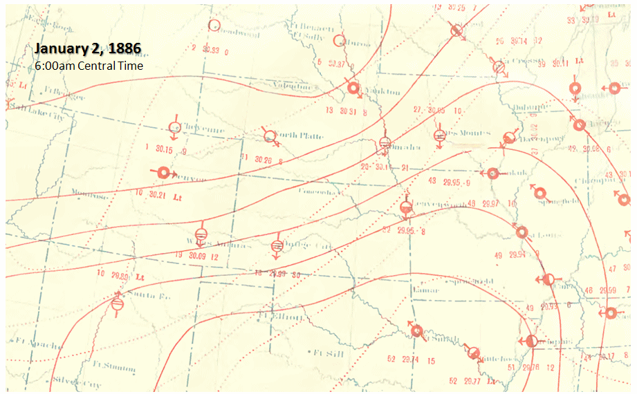
20th Century Reanalysis of 500mb Heights and 700mb Relative Humidity (left) as well as Surface Temperature and Sea Level Pressure for January 2, 1886 at 6:00am (center). U.S. Signal Office Daily Weather Map for January 2 at 6:00am (right).
Blizzard conditions were likely well-underway at Dodge City by daybreak January 2, as sustained winds were out of the north around 30 mph. 0.20" of melted snow was measured at 6:00am and another 0.21" was measured at 2:00pm. No official snow observations were made, however a note was made in the hand-written observation book that a total of 9.43" of snow was measured through the entire month of January 1886. This seems very low considering the aftermath in and around Dodge City. Blizzard conditions continued all day and into the night on January 2 in Dodge City. 0.30" of additional melted snow was measured by 10:00pm on the 2nd, and another 0.48" was measured by 6:00am the morning of January 3rd. This all adds up to a storm total of 1.23" melted snow. Assuming the gauge caught a representative snowfall during this event, then it can be justifiably assumed that 12 to 15" of snowfall actually occurred at Dodge City using a standard snow-to-liquid ratio of 10-12" to 1". Maximum sustained winds from the north continued in the 30 to 40 mph range all the way through 6:00am January 4th! Given the magnitude of snowfall and prolonged wind, it can also be assumed that ground blizzard conditions persisted well after the snow ended early on the 3rd. Thirty-six continuous hours of blizzard conditions were likely experienced in and around Dodge City with this firststorm!
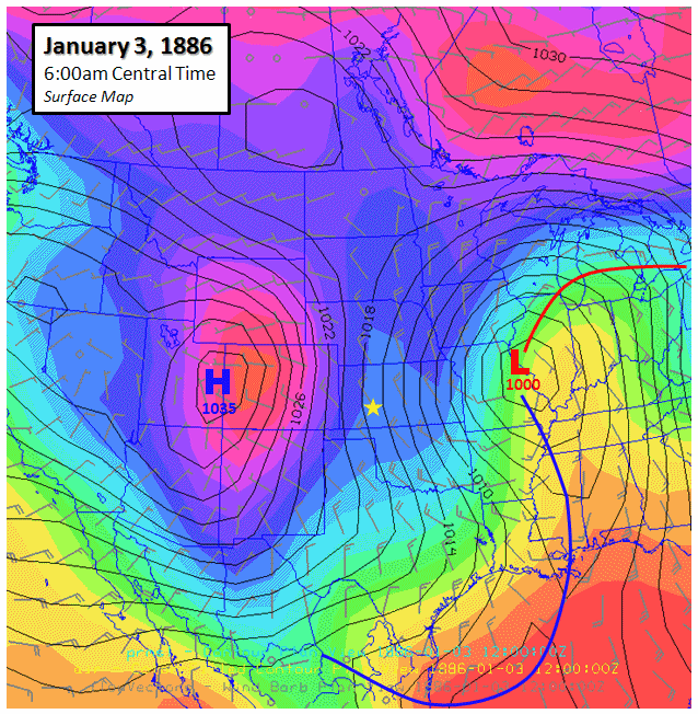

Same as the three figures directly above, except for 24 hours later valid January 3 at 6:00am, showing the storm moving across Kansas into Missouri.
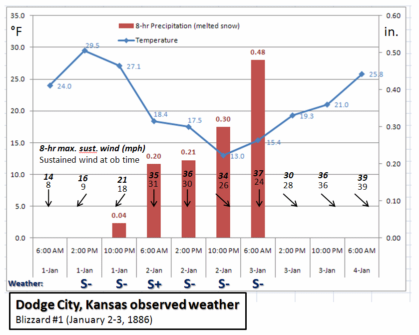
Time series of 8-hourly observations recorded at Dodge City, Kansas during the first blizzard.
The Second Blizzard -- January 7
The second blizzard of the two in early January 1886 was more severe and had greater impacts, despite less snowfall and a bit shorter duration. This blizzard only exacerbated the problems that were spawn and the cleanup from the first storm and was responsible for more injury and death not only to huge populations of cattle, but also humans. Much colder air accompanied the blizzard of January 7th, some of the coldest air Dodge City has ever seen in conjunction with accumulating snow and north winds. There was little time in between storms for much (if any) snow melt, therefore snow and blowing/drifting snow with the second blizzard was far more severe than it would have been without any pre-existing snowpack. The storm that produced the snow was not the classical "Southwest Low". The entire weather pattern shifted to a "northwest flow" situation which allowed brutally cold air to form across western Canada and eventually move south to invade the Great Plains. A severe arctic cold front preceded the northwest-flow storm. On January 6th, Southwest Kansas experienced a relatively warm south wind of 15 to 25 mph with a high of 34° F. There was a wind shift to the north sometime between the 2:00pm and 10:00pm observation on the 6th. An abrupt change was underway as sustained winds of up to 40 mph were recorded. By 10:00pm, the temperature had fallen to 13.5° and by 6:00am the morning of the 7th, the temperature had crashed to -10.0°! Snow had developed after the front moved through during the night of the 6th and 0.10" of melted snow was measured by 6:00am. Snow continued through the morning and early afternoon hours on the 7th with an additional 0.21" of melted snow measured. Sustained winds of 30 to 36 mph continued through the day, and the 2:00pm temperature was -9.0°F at Dodge City, producing a severe wind chill of -35 to -40°F!
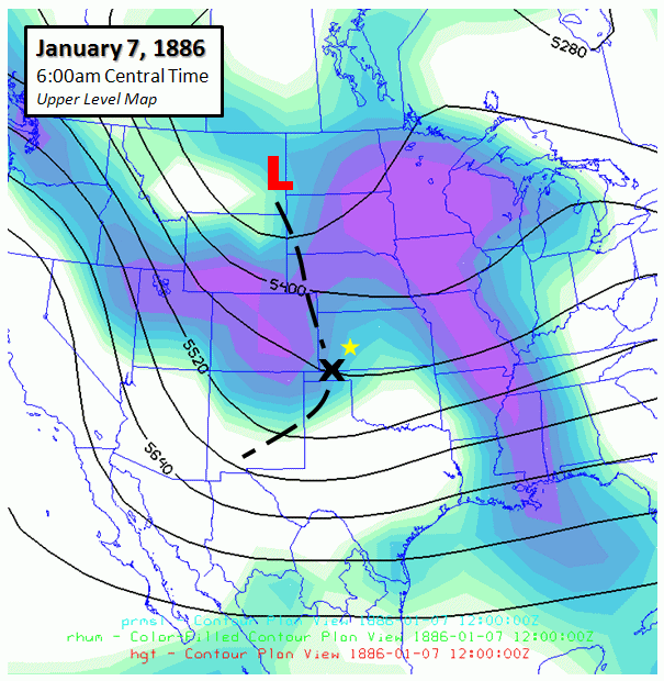
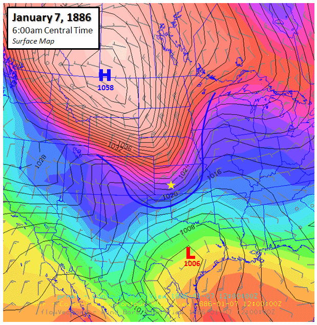
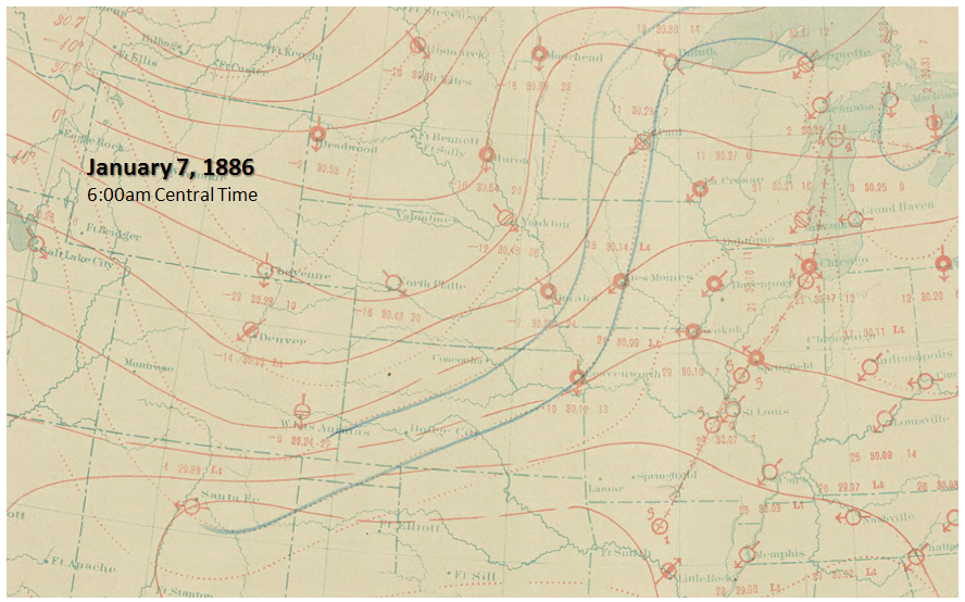
20th Century Reanalysis of 500mb Heights and 700mb Relative Humidity (left) as well as Surface Temperature and Sea Level Pressure for January 7, 1886 at 6:00am (center). U.S. Signal Office Daily Weather Map for January 7 at 6:00am (right). Colors of red to salmon to white in the middle figure denote below zero (°F) temperatures. Note the brutally cold observed temperatures on the U.S. Signal Office weather map of -16° at North Platte, -14° at Denver, and -23° at Cheyenne!
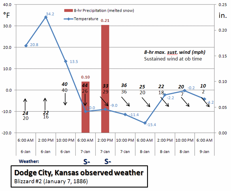
Time series of 8-hourly observations recorded at Dodge City, Kansas during the second blizzard.
20th Century Reanalysis V2 data provided by the NOAA/OAR/ESRL PSD, Boulder, Colorado, USA, from their Web site at https://www.esrl.noaa.gov/psd/
Support for the Twentieth Century Reanalysis Project dataset is provided by the U.S. Department of Energy, Office of Science Innovative and Novel Computational Impact on Theory and Experiment (DOE INCITE) program, and Office of Biological and Environmental Research (BER), and by the National Oceanic and Atmospheric Administration Climate Program Office
U.S. Signal Office daily weather maps provided by NOAA Central Library Data Imaging Project from their website at https://docs.lib.noaa.gov/rescue/dwm/data_rescue_daily_weather_maps.html
Mapping of Reanalysis data produced using Unidata Integrated Data Viewer, which can be downloaded from their website at https://www.unidata.ucar.edu/software/idv/
Story researched and written by Jesse Lee (Jesse.Lee@noaa.gov)
Meteorological analysis and discussion by Mike Umscheid (Mike.Umscheid@noaa.gov)
National Weather Service Dodge City, KS


 Follow us on YouTube