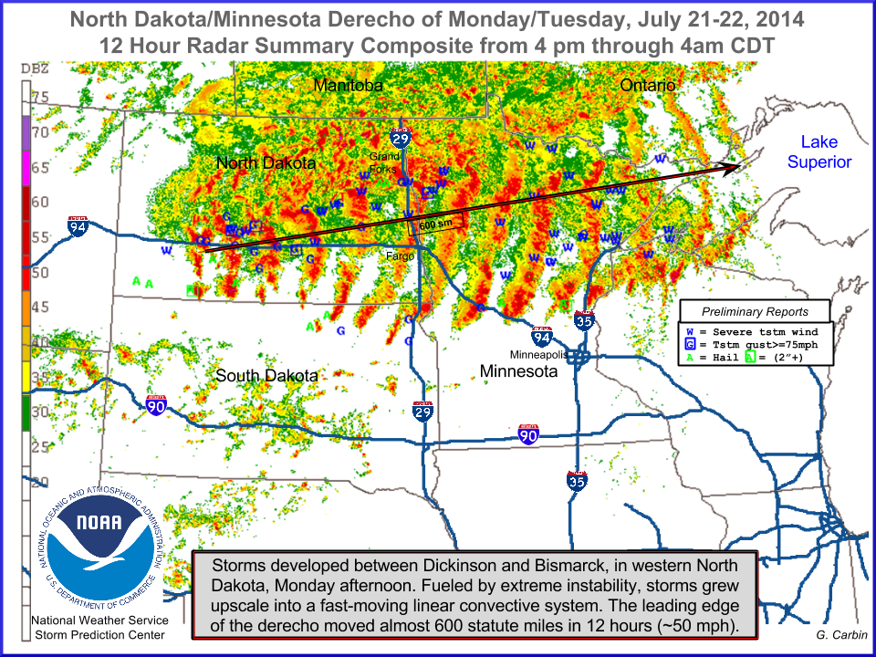
July 21-22, 2014, North Dakota/Minnesota Derecho and Hot Temperatures
|
Monday, July 21st, 2014, brought southerly winds and a very hot and muggy air mass to the region. Temperatures across the Northland reached into the upper 80s to low 90s. In addition to the heat, dew points were extremely high for this area and resulted in Heat Index values in the upper 90s to lower 100s. These hot temperatures and high dew points led to explosive instability that would sustain storms moving in from the west that night.
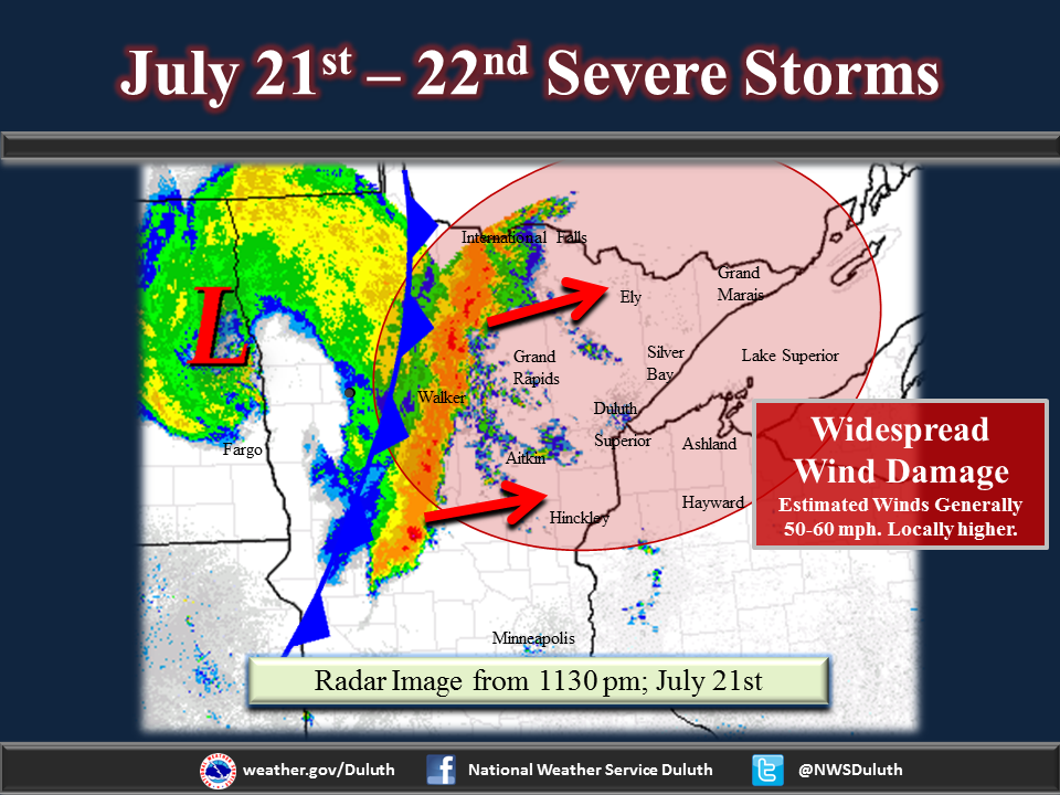
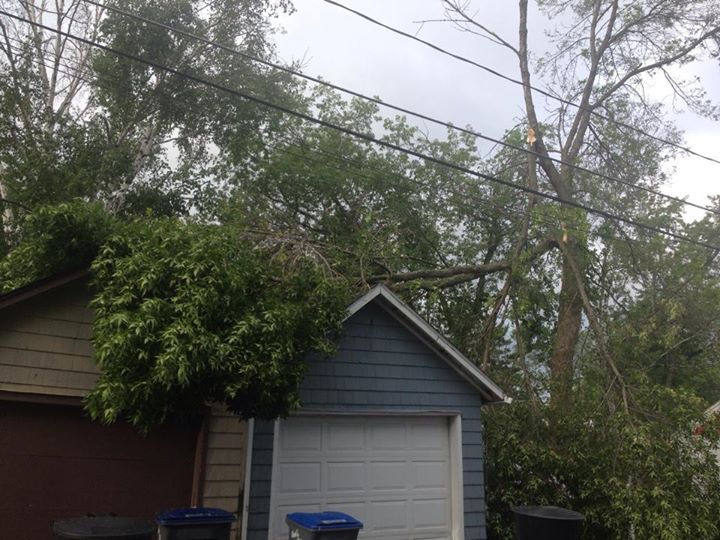
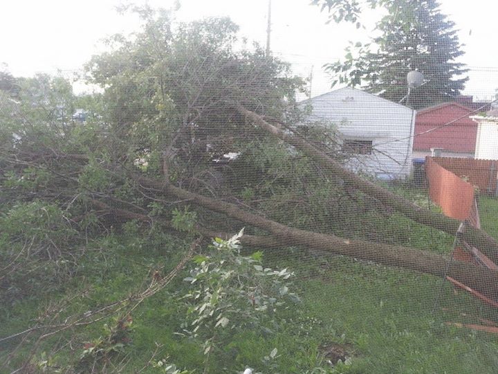
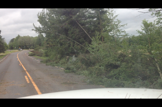
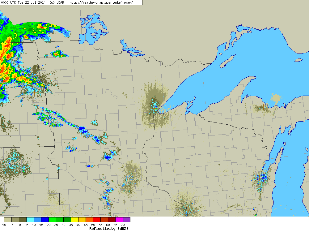
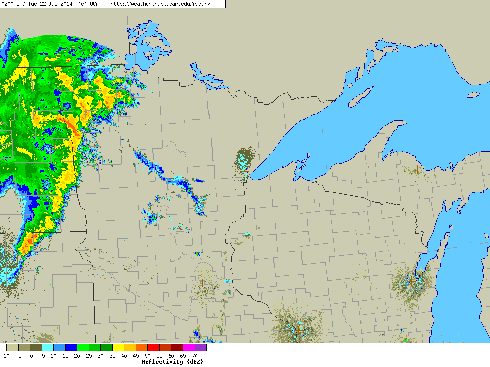
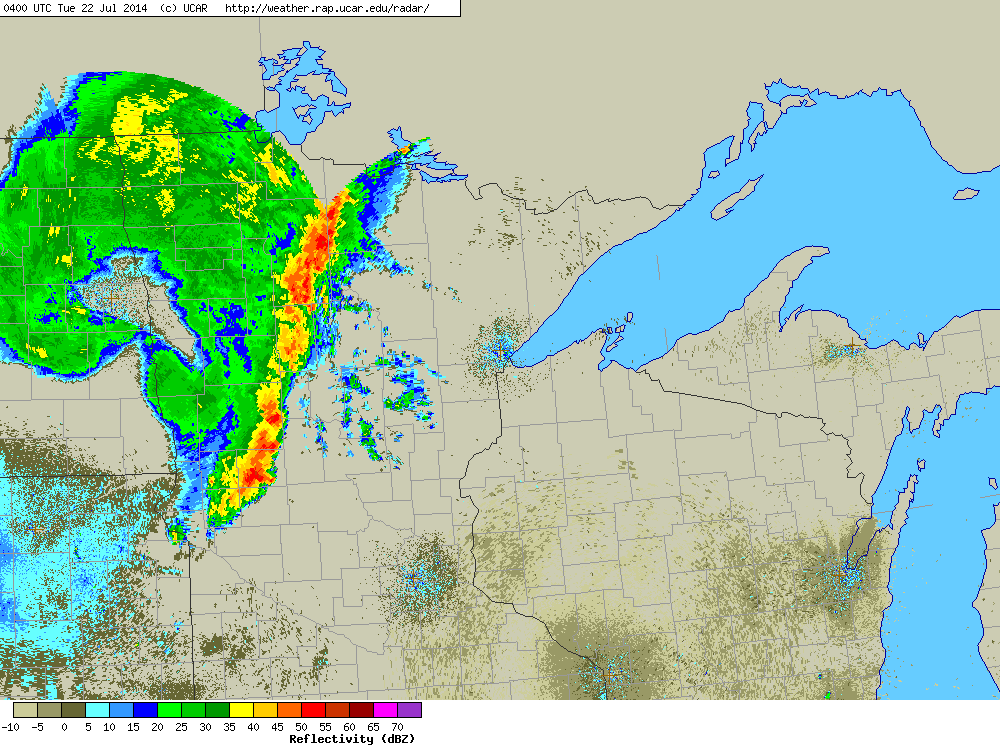
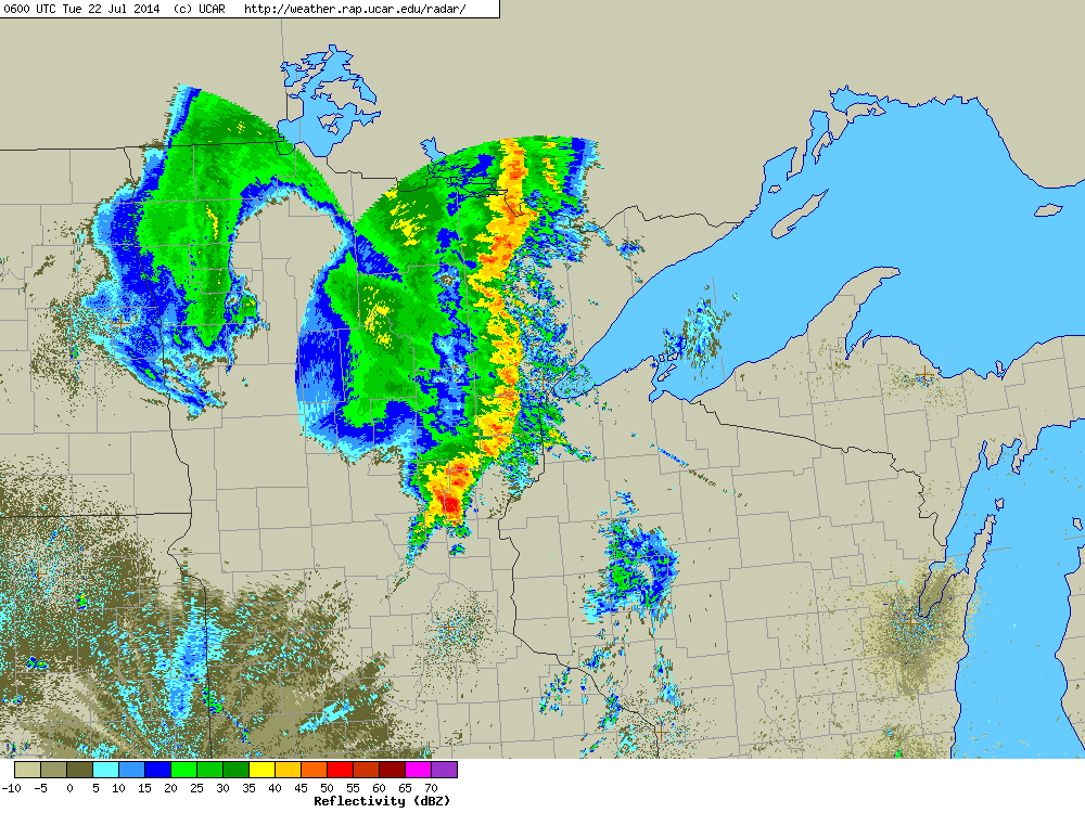
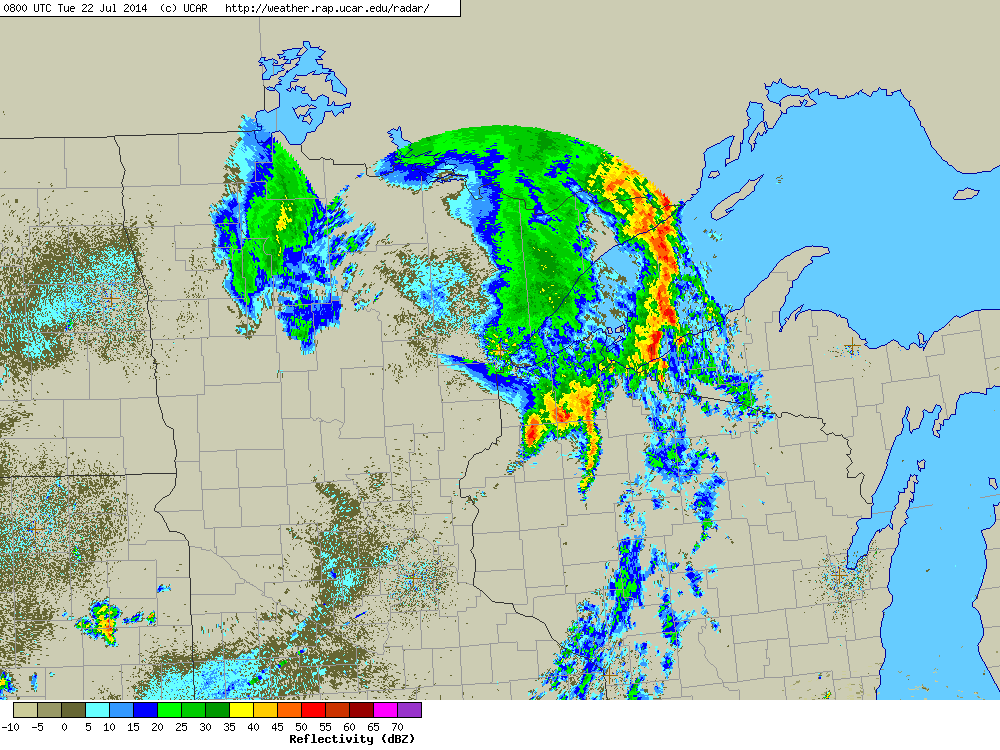
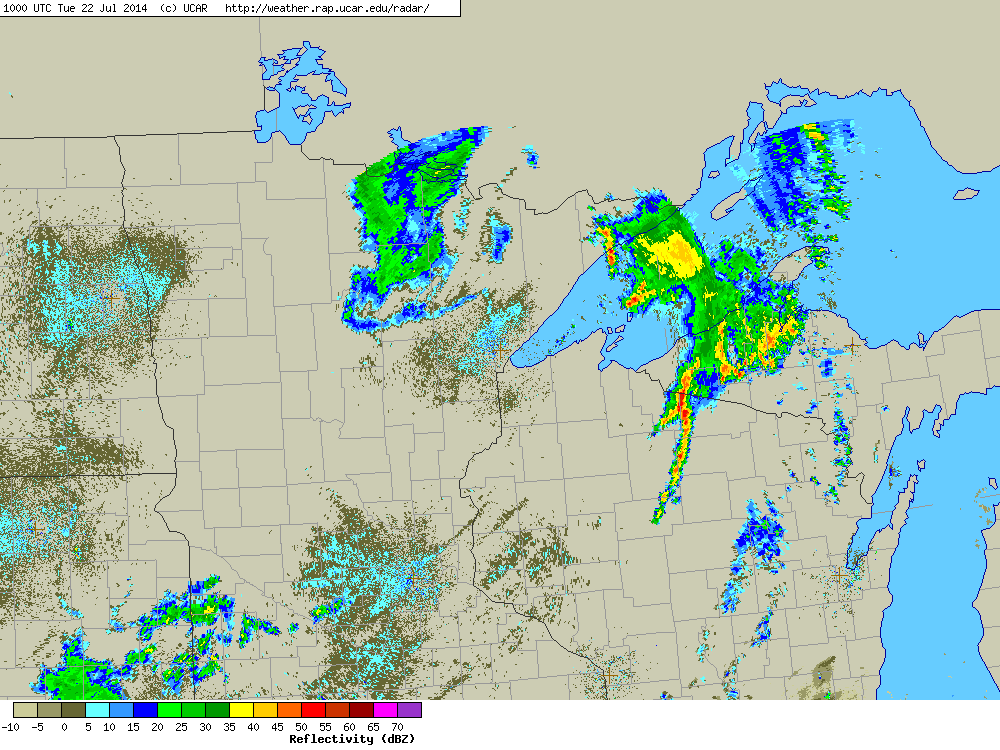
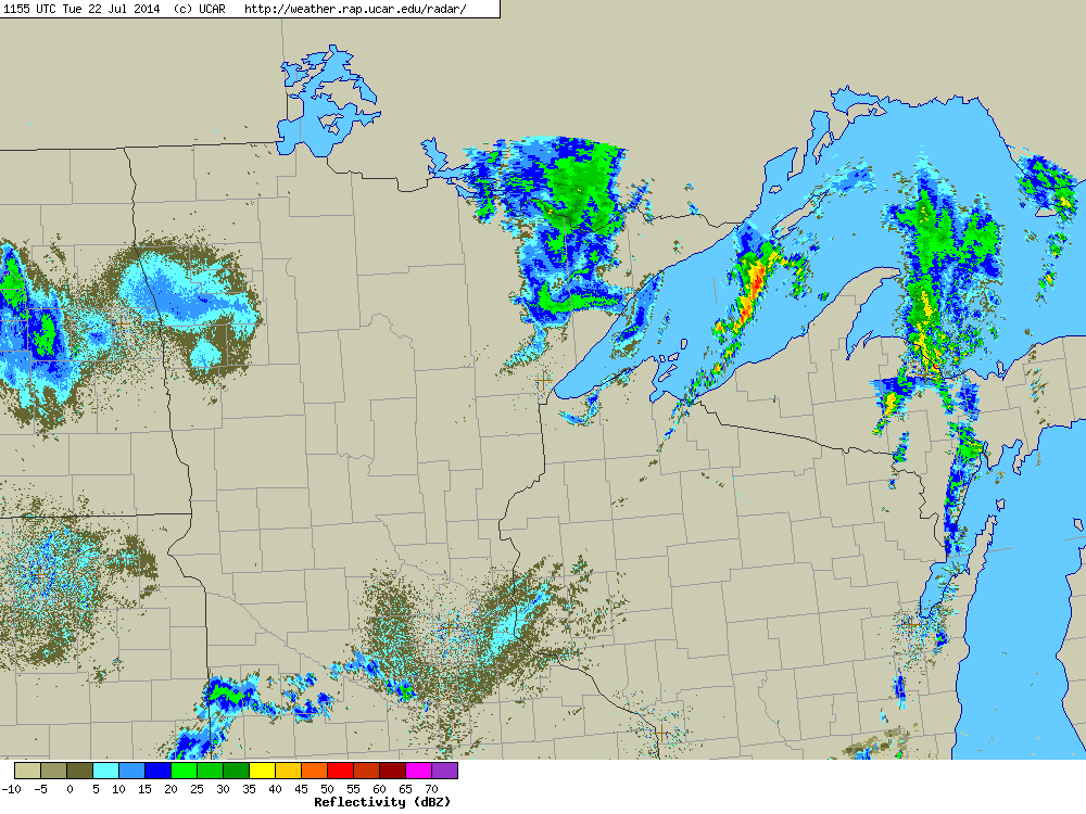
A strong low pressure system, fueled by abundant moisture and instability, swept across the Upper Midwest and Western Lake Superior region Monday night into Tuesday morning. A line of severe storms developed along the cold front, and brought widespread damaging winds over nearly the entire Northland. This derecho formed over North Dakota and moved east through northern Minnesota, northern Wisconsin and western Upper Michigan before diminishing over Lake Superior.
News coverage of the event from the Twin Cities
|
 |
PUBLIC INFORMATION STATEMENT
NATIONAL WEATHER SERVICE DULUTH MN
812 AM CDT TUE JUL 22 2014


...HIGHEST NORTHLAND HEAT INDEX REPORTS YESTERDAY...

LOCATION                       TEMP      TIME/DATE

...MINNESOTA...

...AITKIN...
AITKIN                         105 F     0534 PM 07/21
7 N MCGRATH RWIS               99 F      0500 PM 07/21
MCGREGOR  AIRPORT              96 F      0508 PM 07/21

...CARLTON...
CLOQUET                        94 F      0536 PM 07/21

...CASS...
BENA 5 W (SCHOOL)              100 F     0520 PM 07/21
BENA DNR                       100 F     0259 PM 07/21
LONGVILLE AIRPORT              98 F      0536 PM 07/21
CASS LAKE DOT                  98 F      0330 PM 07/21
PINE RIVER AIRPORT             98 F      0314 PM 07/21

...COOK...
11 NE EAGLE MOUNTAIN           101 F     0239 PM 07/21
4 W GRAND PORTAGE              96 F      0144 PM 07/21

...CROW WING...
BREEZY POINT 2 SW              108 F     0422 PM 07/21
BREEZY POINT 5 SE              107 F     0443 PM 07/21
EAST GULL LAKE 2 ENE           107 F     0302 PM 07/21
BRAINERD AIRPORT               97 F      0353 PM 07/21

...ITASCA...
3 SE EFFIE                     103 F     0409 PM 07/21
7 E EFFIE                      97 F      0520 PM 07/21
2 SSE SQUAW LAKE               97 F      0350 PM 07/21
GRAND RAPIDS                   96 F      0435 PM 07/21

...KOOCHICHING...
NORTHOME                       98 F      0453 PM 07/21
INTERNATIONAL FALLS            96 F      0455 PM 07/21

...LAKE...
SILVER BAY                     95 F      0234 PM 07/21
TWO HARBORS                    94 F      0354 PM 07/21

...PINE...
HINCKLEY                       103 F     0338 PM 07/21
5 SE DUXBURY                   101 F     0405 PM 07/21
3 WNW ASKOV                    101 F     0348 PM 07/21
2 SSW HINCKLEY                 97 F      0510 PM 07/21
MOOSE LAKE AIRPORT             96 F      0355 PM 07/21

...ST. LOUIS...
2 NE DULUTH                    104 F     0241 PM 07/21
1 WSW SAGINAW                  102 F     0520 PM 07/21
ROBINSON                       102 F     0350 PM 07/21
1 WSW ROBINSON                 102 F     0335 PM 07/21
4 SE ARNOLD                    101 F     0251 PM 07/21
1 SSE DULUTH                   100 F     0150 PM 07/21
1 S AURORA                     100 F     0454 PM 07/21
3 NNW COTTON                   99 F      0515 PM 07/21
2 SW PROCTOR                   97 F      0500 PM 07/21
CHISHOLM-HIBBING AIRPORT       96 F      0553 PM 07/21
COOK                           96 F      0514 PM 07/21
ELY                            95 F      0433 PM 07/21
3 S CHISHOLM                   95 F      0435 PM 07/21
EVELETH-VIRGINIA AIRPORT       95 F      0412 PM 07/21
DULUTH AIRPORT                 95 F      0355 PM 07/21
3 NNE HERMANTOWN               95 F      0525 PM 07/21
CRANE LAKE                     94 F      0454 PM 07/21
2 WNW PALMERS                  93 F      0559 PM 07/21
ORR                            93 F      0413 PM 07/21
1 NNE HERMANTOWN               92 F      0410 PM 07/21

...WISCONSIN...

...ASHLAND...
ASHLAND (CWOP)                 105 F     0435 PM 07/21
ASHLAND                        100 F     0404 PM 07/21
1 E ODANAH                     99 F      0500 PM 07/21
GLIDDEN                        97 F      0434 PM 07/21
ASHLAND AIRPORT                96 F      0453 PM 07/21
2 S GLIDDEN                    93 F      0500 PM 07/21

...BAYFIELD...
3 W DRUMMOND                   96 F      0619 PM 07/21
3 W CLAM LAKE                  95 F      0452 PM 07/21
3 SSW CABLE                    94 F      0508 PM 07/21
BAYFIELD                       89 F      0607 PM 07/21

...BURNETT...
2 WSW GRANTSBURG               99 F      0409 PM 07/21
SIREN                          96 F      0350 PM 07/21

...DOUGLAS...
4 WNW WENTWORTH                105 F     0510 PM 07/21
SUPERIOR                       101 F     0515 PM 07/21
1 WSW MAPLE                    101 F     0442 PM 07/21
5 WNW HAWTHORNE                100 F     0405 PM 07/21
3 WSW WENTWORTH                99 F      0304 PM 07/21

...IRON...
2 ENE KIMBALL                  96 F      0300 PM 07/21

...PRICE...
2 SSW FIFIELD                  97 F      0400 PM 07/21
10 WSW FIFIELD                 96 F      0357 PM 07/21
6 WSW SPIRIT                   92 F      0410 PM 07/21
PHILLIPS                       91 F      0315 PM 07/21

...SAWYER...
5 NW WINTER                    102 F     0306 PM 07/21
HAYWARD                        94 F      0553 PM 07/21

...WASHBURN...
5 W SHELL LAKE                 98 F      0419 PM 07/21

OBSERVATIONS ARE COLLECTED FROM A VARIETY OF SOURCES WITH VARYING
EQUIPMENT AND EXPOSURE. NOT ALL DATA LISTED ARE CONSIDERED OFFICIAL.
 |
 |
 |
 |
| International Falls, MN | International Falls, MN | Superior, WI | West Duluth, MN |
 |
 |
 |
 |
| Lake Nebagamon, WI | Eveleth, MN | Eveleth, MN | Eveleth, MN |
 |
 |
 |
 |
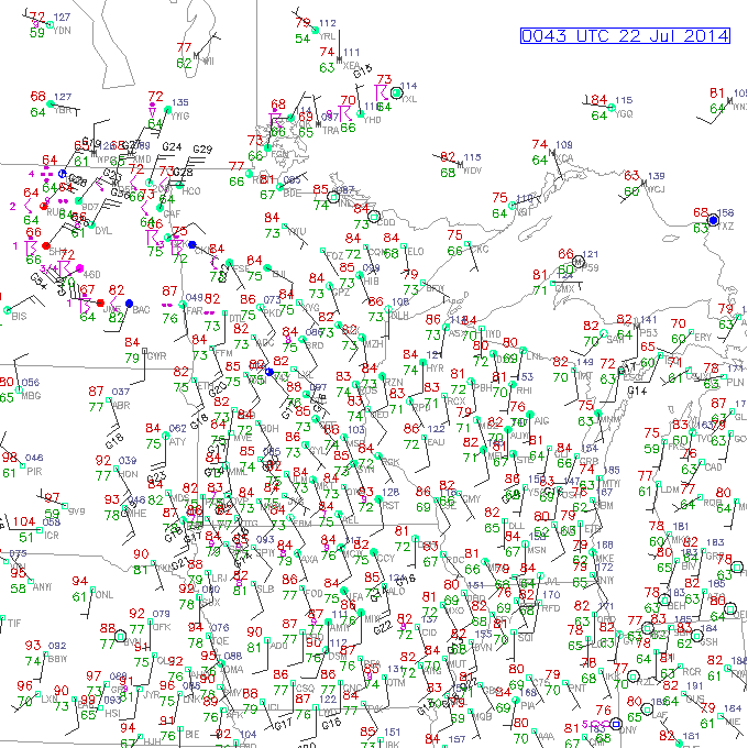
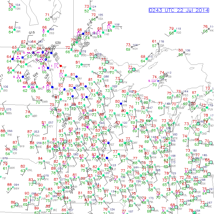
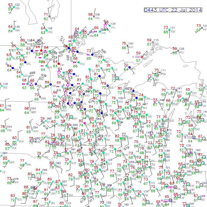
| 7PM July 21 | 9PM July 21 | 11PM July 21 | 1AM July 22 |
 |
 |
 |
|
| 3AM July 22 | 5AM July 22 | 7AM July 22 |
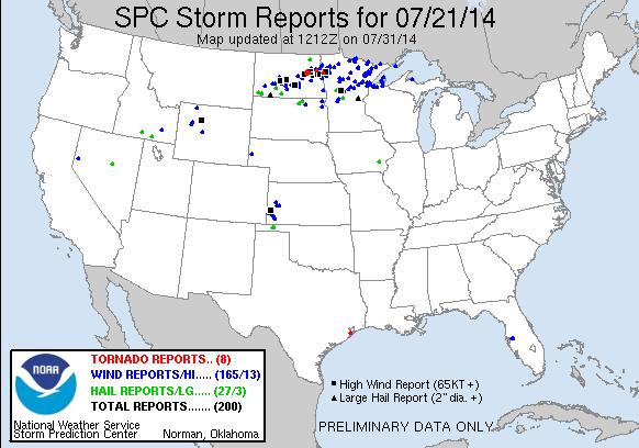
Click the image above for Storm Reports from around the country.
000
NWUS53 KDLH 222230
LSRDLH
PRELIMINARY LOCAL STORM REPORT...SUMMARY
NATIONAL WEATHER SERVICE DULUTH MN
529 PM CDT TUE JUL 22 2014
..TIME... ...EVENT... ...CITY LOCATION... ...LAT.LON...
..DATE... ....MAG.... ..COUNTY LOCATION..ST.. ...SOURCE....
..REMARKS..
1108 PM TSTM WND DMG 10 S BIRCHDALE 48.48N 94.08W
07/21/2014 KOOCHICHING MN PUBLIC
2 TREES DOWN ACROSS COUNTY ROAD 86.
1126 PM TSTM WND DMG 1 NNW FEDERAL DAM 47.25N 94.22W
07/21/2014 CASS MN CO-OP OBSERVER
NUMEROUS TREES UPROOTED WITH SOME SHEARED OFF ABOVE THE
GROUND. POWER STILL OUT AS OF 947 AM.
1137 PM TSTM WND DMG NISSWA 46.50N 94.30W
07/21/2014 CROW WING MN PUBLIC
LOTS OF TREES BLOWN DOWN IN NISSWA. THE REPORT WAS
GATHERED VIA SOCIAL MEDIA. THE TIME WAS ESTIMATED BASED
ON RADAR.
1140 PM TSTM WND DMG LITTLEFORK 48.40N 93.56W
07/21/2014 KOOCHICHING MN PUBLIC
SEVERAL TREES DOWN. TIME ESTIMATED BY RADAR.
1145 PM HAIL 3 N BRAINERD 46.40N 94.19W
07/21/2014 E0.25 INCH CROW WING MN CO-OP OBSERVER
1146 PM TSTM WND DMG 2 SW INTERNATIONAL FALL 48.57N 93.44W
07/21/2014 KOOCHICHING MN PUBLIC
MORE THAN 200 TREES WERE BLOWN DOWN AT A COUNTRY CLUB.
PARTS OF THE ROOF FROM THE OUTDOOR DECK BY THE CLUBHOUSE
ENDED UP ON THE NUMBER 18 TEE. THE REPORT WAS GATHERED
VIA SOCIAL MEDIA. THE TIME WAS ESTIMATED BASED ON RADAR.
1148 PM TSTM WND DMG W INTERNATIONAL FALLS 48.59N 93.41W
07/21/2014 KOOCHICHING MN PUBLIC
A CARPORT AND WOODSHED WERE BLOWN DOWN AND DESTROYED. THE
REPORT WAS GATHERED VIA SOCIAL MEDIA. THE TIME WAS
ESTIMATED BASED ON RADAR.
1150 PM TSTM WND DMG LITTLEFORK 48.40N 93.56W
07/21/2014 KOOCHICHING MN LAW ENFORCEMENT
POWER OUTAGE
1150 PM TSTM WND DMG 11 WSW INTERNATIONAL FA 48.53N 93.63W
07/21/2014 KOOCHICHING MN LAW ENFORCEMENT
POWER OUTAGE.
1150 PM TSTM WND DMG 5 S CROSSLAKE 46.61N 94.09W
07/21/2014 CROW WING MN PUBLIC
TREE DOWN AND PONTOON BOAT FLIPPED ON HORSESHOE LAKE. VIA
SOCIAL MEDIA.
1156 PM TSTM WND GST BOWSTRING 47.54N 93.80W
07/21/2014 E45.00 MPH ITASCA MN AMATEUR RADIO
1157 PM TSTM WND GST EMILY 46.76N 93.96W
07/21/2014 E45.00 MPH CROW WING MN TRAINED SPOTTER
1205 AM TSTM WND GST NISSWA 46.50N 94.30W
07/22/2014 E45.00 MPH CROW WING MN LAW ENFORCEMENT
TREES DOWN
1205 AM TSTM WND GST PEQUOT LAKES 46.60N 94.32W
07/22/2014 E45.00 MPH CROW WING MN LAW ENFORCEMENT
TREES DOWN
1209 AM TSTM WND DMG 8 N TOGO 47.94N 93.16W
07/22/2014 KOOCHICHING MN TRAINED SPOTTER
TREES DOWN
1214 AM TSTM WND GST 6 S COHASSET 47.18N 93.62W
07/22/2014 E45.00 MPH ITASCA MN AMATEUR RADIO
1214 AM TSTM WND GST 5 E SQUAW LAKE 47.63N 94.03W
07/22/2014 E45.00 MPH ITASCA MN AMATEUR RADIO
1218 AM TSTM WND DMG 10 N TOGO 47.97N 93.16W
07/22/2014 KOOCHICHING MN TRAINED SPOTTER
TREES DOWN
1229 AM TSTM WND DMG AITKIN 46.53N 93.71W
07/22/2014 AITKIN MN LAW ENFORCEMENT
TREES DOWN.
1229 AM TSTM WND GST MCGREGOR 46.61N 93.31W
07/22/2014 E50.00 MPH AITKIN MN FIRE DEPT/RESCUE
1229 AM TSTM WND DMG HILL CITY 46.99N 93.60W
07/22/2014 AITKIN MN LAW ENFORCEMENT
TREES DOWN.
1230 AM TSTM WND DMG BIG SANDY LAKE 46.76N 93.29W
07/22/2014 AITKIN MN AMATEUR RADIO
SEVERAL TREES A FOOT IN DIAMETER DOWN.
1230 AM TSTM WND DMG BIG SANDY LAKE 46.76N 93.29W
07/22/2014 AITKIN MN BROADCAST MEDIA
TREE FELL ON RV. BOAT DOCK DAMAGED. TIME ESTIMATED.
1242 AM TSTM WND GST 4 NE FLOODWOOD 46.97N 92.87W
07/22/2014 M74.00 MPH ST. LOUIS MN CO-OP OBSERVER
TREES DOWN AND PROPERTY DAMAGE.
1247 AM TSTM WND GST AITKIN 46.53N 93.71W
07/22/2014 E70.00 MPH AITKIN MN LAW ENFORCEMENT
NUMEROUS TREES DOWN THROUGHOUT THE COUNTY
1247 AM TSTM WND DMG 5 E SQUAW LAKE 47.63N 94.03W
07/22/2014 ITASCA MN AMATEUR RADIO
DEAD TREE 14 TO 16 INCHES IN DIAMETER DOWN.
1247 AM TSTM WND DMG HILL CITY 46.99N 93.60W
07/22/2014 AITKIN MN AMATEUR RADIO
8 INCH DIAMETER TREE DOWN BLOCKING HIGHWAY 169. POWER
OUTAGE.
1257 AM TSTM WND DMG 30 NW ELY 48.21N 92.31W
07/22/2014 ST. LOUIS MN PARK/FOREST SRVC
*** 3 INJ *** CAMPERS INJURED FROM TREE FALLING ON
CAMPSITE ON LOON LAKE.
0101 AM TSTM WND DMG 7 S EVELETH 47.36N 92.54W
07/22/2014 ST. LOUIS MN PUBLIC
A 25 INCH DIAMATER TREE WAS BLOWN DOWN. THE REPORT WAS
GATHERED VIA SOCIAL MEDIA. THE TIME WAS ESTIMATED BASED
ON RADAR.
0102 AM TSTM WND DMG 3 S EVELETH 47.42N 92.54W
07/22/2014 ST. LOUIS MN PUBLIC
A COUPLE STRUCTURES JUST WEST OF HIGHWAY 53 TOOK DAMAGE
WITH SOME WALLS TORN OFF. THIS INFORMATION WAS PROVIDED
VIA SOCIAL MEDIA. THE TIME WAS ESTIMATED BASED ON RADAR.
0103 AM TSTM WND DMG VIRGINIA 47.52N 92.51W
07/22/2014 ST. LOUIS MN PUBLIC
A LARGE TREE WAS UPROOTED. THE REPORT WAS GATHERED VIA
SOCIAL MEDIA. THE TIME WAS ESTIMATED BASED ON RADAR.
0103 AM TSTM WND DMG 3 SE EVELETH 47.43N 92.50W
07/22/2014 ST. LOUIS MN FIRE DEPT/RESCUE
LOTS OF LARGE TREES DOWN. THE TIME WAS ESTIMATED BASED ON
RADAR.
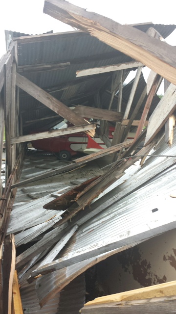
0103 AM TSTM WND DMG 3 SSE EVELETH 47.42N 92.52W
07/22/2014 ST. LOUIS MN FIRE DEPT/RESCUE
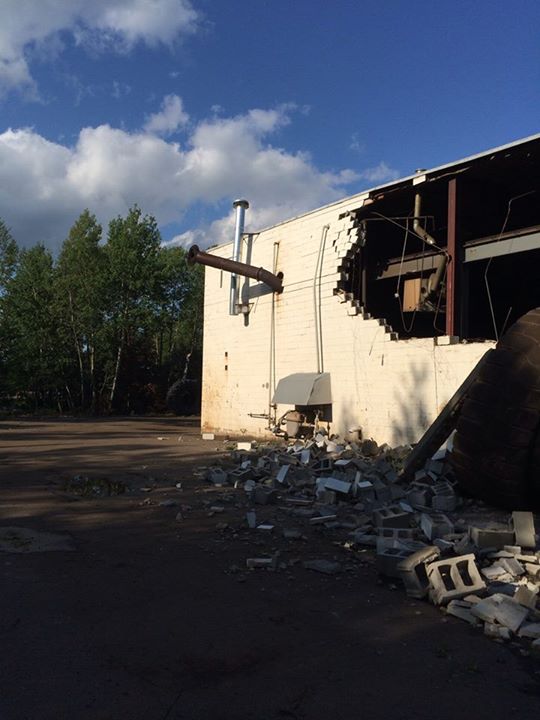
DAMAGE AT THE EVELETH-VIRGINIA MUNICIPAL AIRPORT. ONE
HANGER AND THE PLANE INSIDE WERE DESTROYED. TWO OTHER
HANGERS WERE DAMAGED. ONE GARAGE ROOF WAS BLOWN OFF. THE
TIME WAS ESTIMATED BASED ON RADAR.
0103 AM TSTM WND DMG 29 NNW ELY 48.29N 92.09W
07/22/2014 ST. LOUIS MN PARK/FOREST SRVC
*** 2 INJ *** CAMPERS INJURED BY TREE FALLING ON TENT AT
CAMPSITE ON LADY BOOT BAY OF LAC LA CROIX LAKE.
0107 AM TSTM WND DMG 2 S ESKO 46.68N 92.36W
07/22/2014 CARLTON MN PUBLIC
A FEW TREES ABOUT 6 INCHES IN DIAMETER WERE BLOWN DOWN.
THE REPORT WAS GATHERED VIA SOCIAL MEDIA. THE TIME WAS
ESTIMATED BASED ON RADAR.
0109 AM TSTM WND DMG FLOODWOOD 46.93N 92.92W
07/22/2014 ST. LOUIS MN TRAINED SPOTTER
TREES DOWN. ONE WAS 12 INCHES IN DIAMETER.
0109 AM TSTM WND DMG GRAND LAKE 46.88N 92.40W
07/22/2014 ST. LOUIS MN PUBLIC
POWER OUTAGE.
0113 AM TSTM WND DMG 1 ESE BIWABIK 47.53N 92.33W
07/22/2014 ST. LOUIS MN TRAINED SPOTTER
DOCK ON EMBARRASS LAKE FLIPPED OVER. AN 8 INCH DIAMETER
TREE SNAPPED AND FELL ON THE DOCK. THE TIME WAS ESTIMATED
BASED ON RADAR.
0115 AM TSTM WND DMG RICE LAKE TWP 46.90N 92.11W
07/22/2014 ST. LOUIS MN PUBLIC
6-12 INCH DIAMETER ASPEN TREE SNAPPED. TIME ESTIMATED OFF
RADAR. REPORT AND PHOTOGRAPH VIA SOCIAL MEDIA.
0115 AM TSTM WND DMG AURORA 47.53N 92.24W
07/22/2014 ST. LOUIS MN PUBLIC
MANY SMALL TREES AND SOME LARGE TREES DOWN IN AURORA. THE
TIME WAS ESTIMATED BASED ON RADAR.
0117 AM TSTM WND DMG HOYT LAKES 47.51N 92.15W
07/22/2014 ST. LOUIS MN TRAINED SPOTTER
MANY TREES BETWEEN 6 AND 12 INCHES IN DIAMETER ARE DOWN
IN HOYT LAKES.
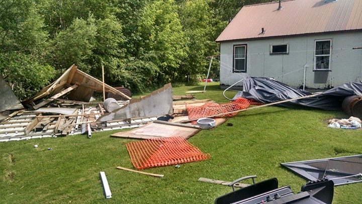
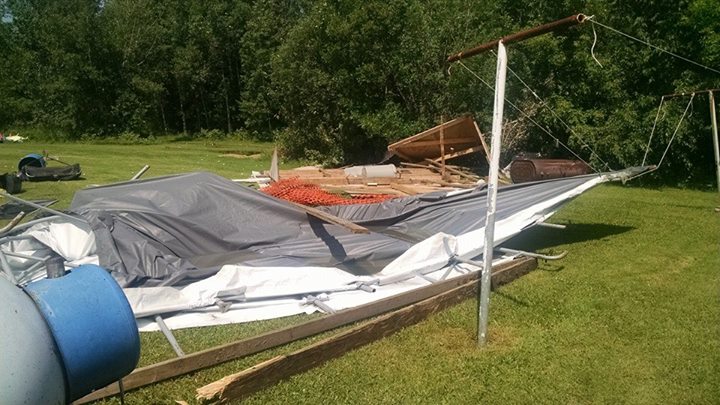
0118 AM TSTM WND DMG WEST DULUTH 46.74N 92.19W
07/22/2014 ST. LOUIS MN PUBLIC
A LARGE TREE WAS BLOWN OVER AND FELL ONTO A FENCE. THE
REPORT WAS GATHERED VIA SOCIAL MEDIA. THE TIME WAS BASED
ON RADAR.
0121 AM TSTM WND DMG E SUPERIOR 46.70N 92.06W
07/22/2014 DOUGLAS WI PUBLIC
A LARGE TREE LIMB FELL ONTO A GARAGE. THE REPORT WAS
GATHERED VIA SOCIAL MEDIA. THE TIME WAS ESTIMATED BASED
ON RADAR.
0122 AM TSTM WND DMG CONGDON PARK 46.82N 92.06W
07/22/2014 ST. LOUIS MN PUBLIC
A PINE TREE WAS BLOWN DOWN OVER THE ROAD NEAR THE
INTERSECTION OF VERMILLION ROAD AND LAKEVIEW DRIVE IN
DULUTH. THE REPORT WAS GATHERED VIA SOCIAL MEDIA. THE
TIME WAS ESTIMATED BASED ON RADAR.
0123 AM TSTM WND GST DULUTH 46.78N 92.12W
07/22/2014 M50.00 MPH ST. LOUIS MN ASOS
0124 AM TSTM WND DMG EMBARRASS 47.66N 92.20W
07/22/2014 ST. LOUIS MN LAW ENFORCEMENT
TREES AND POWER LINES DOWN.
0130 AM MARINE TSTM WIND DULUTH 46.78N 92.12W
07/22/2014 M46.00 MPH ST. LOUIS MN MESONET
MEASURED AT DULM5.
0134 AM TSTM WND DMG BABBITT 47.65N 91.94W
07/22/2014 ST. LOUIS MN LAW ENFORCEMENT
TREES AND POWER LINES DOWN.
0134 AM TSTM WND DMG BABBITT 47.65N 91.94W
07/22/2014 ST. LOUIS MN PUBLIC
TREES WERE UPROOTED AND A LARGE SHED WAS DESTROYED.
0136 AM TSTM WND DMG EVELETH 47.46N 92.54W
07/22/2014 ST. LOUIS MN LAW ENFORCEMENT
POWER LINES DOWN ROUTE 53 AND 37.
0137 AM TSTM WND DMG POPLAR 46.58N 91.79W
07/22/2014 DOUGLAS WI PUBLIC
A LARGE TREE ABOUT 24 INCHES IN DIAMETER WAS BLOWN DOWN
ONTO A FENCE. THE REPORT WAS GATHERED VIA SOCIAL MEDIA.
THE TIME WAS ESTIMATED BASED ON RADAR.
0138 AM TSTM WND DMG PELLAND 48.52N 93.58W
07/22/2014 KOOCHICHING MN PUBLIC
ROOF OFF HOUSE NEAR PELLAND JUNCTION. TIME ESTIMATED BY
RADAR.
0138 AM TSTM WND DMG 3 NNE POPLAR 46.62N 91.77W
07/22/2014 DOUGLAS WI LAW ENFORCEMENT
SEVERAL STRUCTURES DAMAGED. SHINGLES PEELED OFF AND
SOFFITS UPLIFTED.
0146 AM TSTM WND DMG 6 S ELY 47.82N 91.84W
07/22/2014 ST. LOUIS MN COUNTY OFFICIAL
SUBSTANTIAL TREE DAMAGE ON CR 120 NEAR AIRPORT. TREES
SNAPPED OFF HALF WAY UP
0200 AM MARINE TSTM WIND 1 N PORT WING 46.79N 91.39W
07/22/2014 M38.00 MPH BAYFIELD WI BUOY
0200 AM TSTM WND DMG IRON RIVER 46.56N 91.41W
07/22/2014 BAYFIELD WI PUBLIC
4-5 INCH TREE LIMBS DOWN AND CORN FLATTENED. TIME
ESTIMATE.
0204 AM TSTM WND DMG 20 E ELY 47.90N 91.42W
07/22/2014 LAKE MN PARK/FOREST SRVC
*** 1 INJ *** CAMPER INJURED FROM TREE FALLING ON
CAMPSITE.
0214 AM TSTM WND DMG 1 N SAND BAY 46.95N 90.89W
07/22/2014 BAYFIELD WI CO-OP OBSERVER
SEVERAL LARGE TREES DOWN ON LITTLE SAND BAY ROAD
0215 AM MARINE TSTM WIND 6 NNE DEVILS ISLAND 47.15N 90.68W
07/22/2014 M61.00 MPH LSZ162 WI SHIP
TIME ESTIMATED. SHIP STEWART J. CORT.
0220 AM TSTM WND DMG 3 SW BAYFIELD 46.79N 90.86W
07/22/2014 BAYFIELD WI CO-OP OBSERVER
5-6 INCH DIAMETER TREE BROKEN.
0222 AM MARINE TSTM WIND 6 N DEVILS ISLAND 47.16N 90.73W
07/22/2014 E45.00 MPH LSZ162 WI SHIP
SHIP ALGOLAKE. THUNDERSTORM WITH STRONG WINDS AND HEAVY
RAIN. TIME ESTIMATED OFF RADAR.
0224 AM TSTM WND GST ASHLAND 46.58N 90.87W
07/22/2014 M46.00 MPH ASHLAND WI ASOS
0225 AM TSTM WND GST 1 NNW ASHLAND 46.60N 90.89W
07/22/2014 M62.00 MPH ASHLAND WI MESONET
MEASURED AT ASHLAND MARINA. TIME ESTIMATED BY RADAR.
0225 AM TSTM WND DMG SEA GULL LAKE 48.13N 90.95W
07/22/2014 COOK MN EMERGENCY MNGR
WIDESPREAD TREES DOWN NEAR END OF GUNFLINT TRAIL NEAR
SEAGULL LAKE.
0229 AM TSTM WND DMG DULUTH HEIGHTS 46.82N 92.16W
07/22/2014 ST. LOUIS MN PUBLIC
POWER OUTAGE.
0356 AM HAIL 20 E HAYWARD 46.01N 91.06W
07/22/2014 M0.75 INCH SAWYER WI TRAINED SPOTTER
COVERS THE GROUND
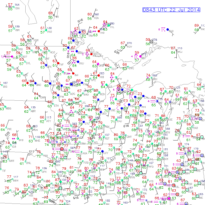
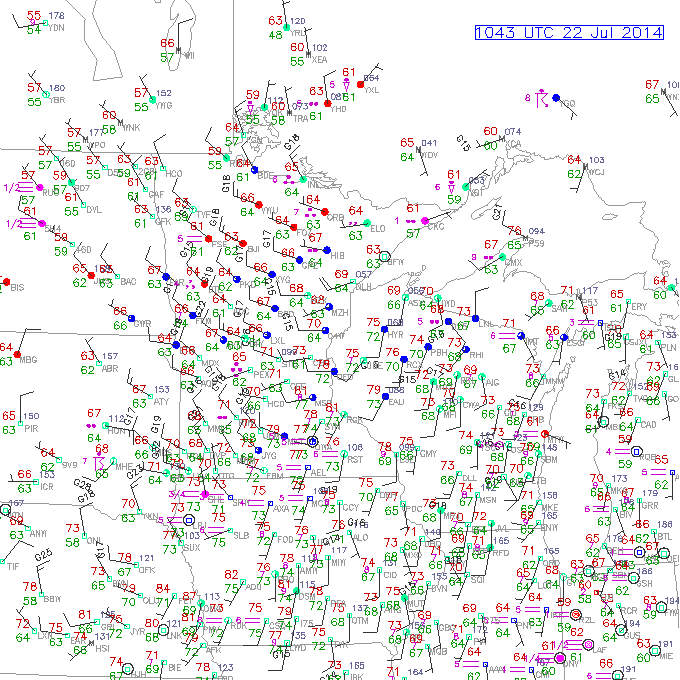
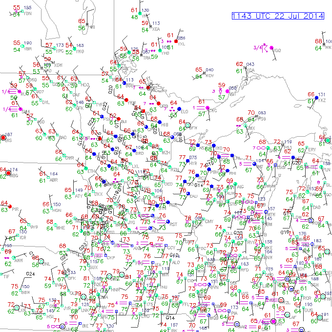
Surface Observations
 |
 |
 |
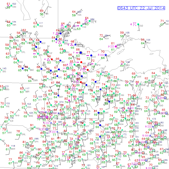 |
| 7PM July 21 | 9PM July 21 | 11PM July 21 | 1AM July 22 |
 |
 |
 |
 |
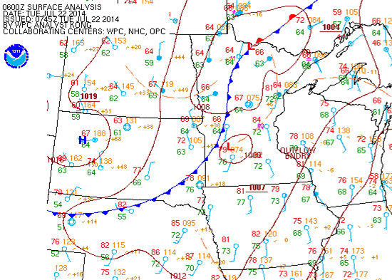
| Surface Analysis 1AM July 22 |
3AM July 22 | 5AM July 22 | 7AM July 22 |
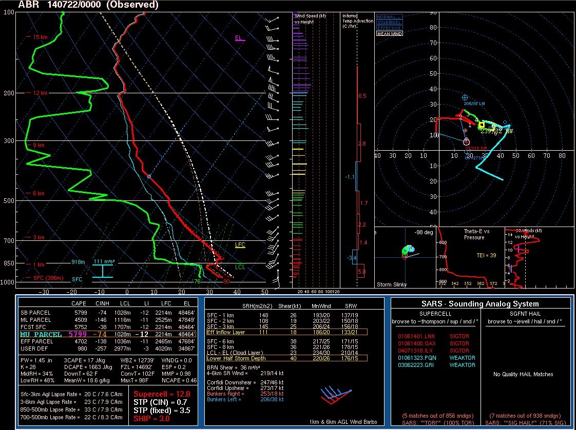 |
| 00Z (7PM) July 21 Sounding from Aberdeen, SD, showing explosive environment ahead of the storms. |
 |
Media use of NWS Web News Stories is encouraged! Please acknowledge the NWS as the source of any news information accessed from this site. |
|


 Follow us on YouTube