Overview
|
A strong thunderstorm developed over northern Ashland County and moved east across northern Iron County and into western Upper Michigan during the evening hours last Thursday, July 25, 2013. The storm developed quickly over northern Ashland County starting around 6:20 PM CDT and quickly moved east-southeast through Montreal and Pence and into Gogebic County, Michigan, by 7:15 PM CDT. The storm continued east-southeast across western Upper Michigan thereafter. These storms were part of a larger system that supported thunderstorms across much of the Northland. The National Weather Service in Duluth investigated reports of wind damage in northern Iron County (Figure 2) and in Montreal (Figure 3). The survey team found sporadic tree damage along US Highway 2 starting 1.6 miles east of Saxon and in Iron Belt on State Highway 77. The damage area continued east-southeast through Pence and Montreal, to the eastern shore of the Gile Flowage, and into western Gogebic County, Michigan, from 2.5 miles southeast of Norrie to 1.2 miles southeast of Van Buskirk. The observed damage included uprooted and broken trees. There was a concentrated area of damage associated with a locally stronger microburst in Montreal, where some structural damage occurred when trees fell on a couple of houses. Several parked cars in Montreal were also damaged by falling trees. The overall damage path evolution was consistent with non-tornadic thunderstorm winds, or so-called "straight-line" wind damage, due to a downburst with wind speeds generally in the 50 to 60 mph range. Note: Additional damage to the west and east of the surveyed area may have occurred during this thunderstorm. |
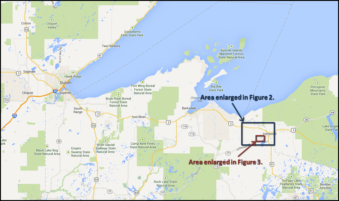 Figure 1: Aerial Overview |
 |
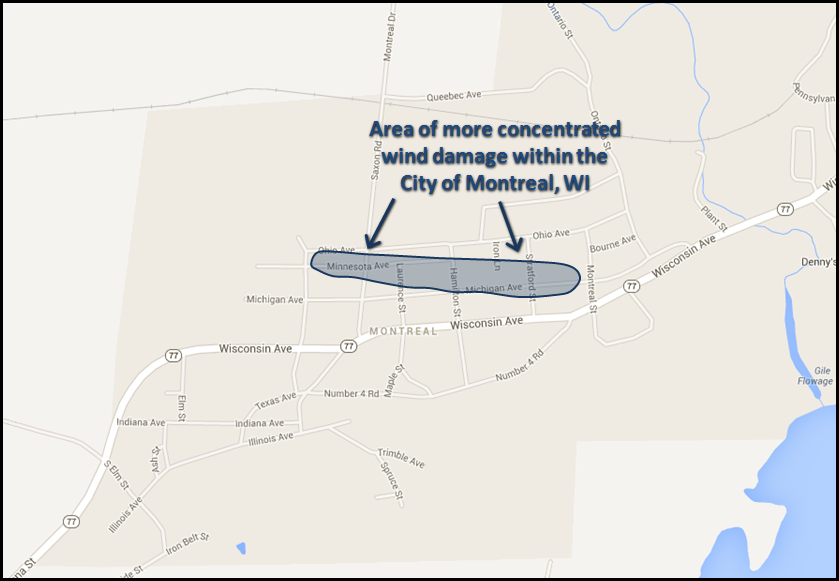 |
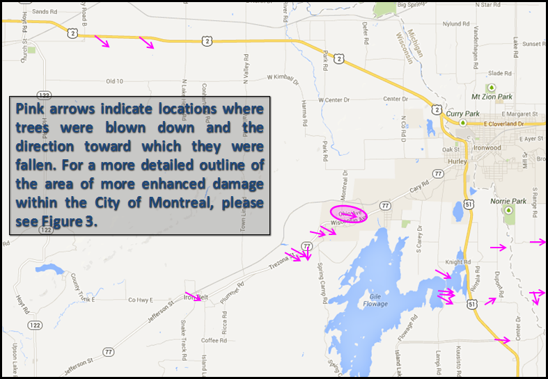
| Figure 2: Survey Area | Figure 3: Montreal Wind Damage Area |
Photos
 |
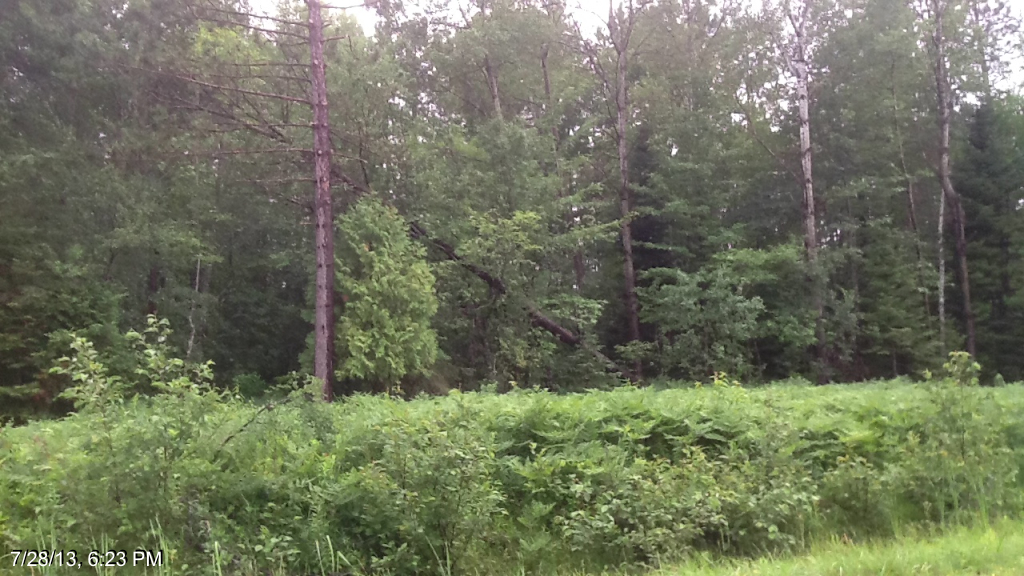 |
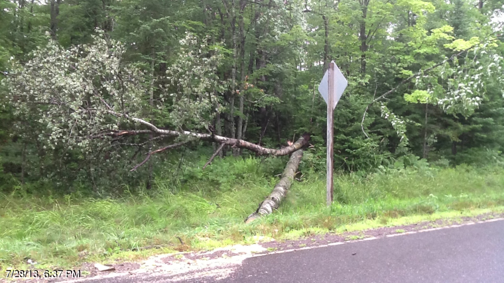
| Broken maple and birch trees on the eastern shore of the Gile Flowage (NWS Photo) |
Uprooted tree south of County Rd C (NWS Photo) |
Radar
 |
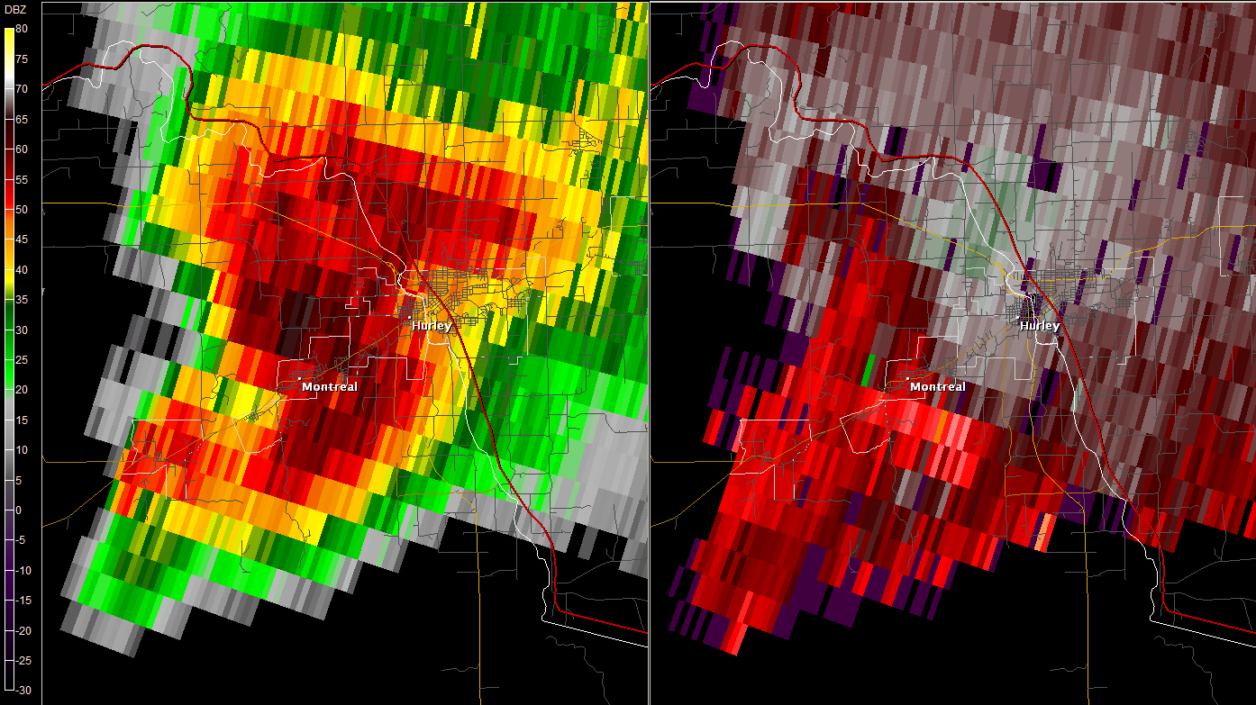 |
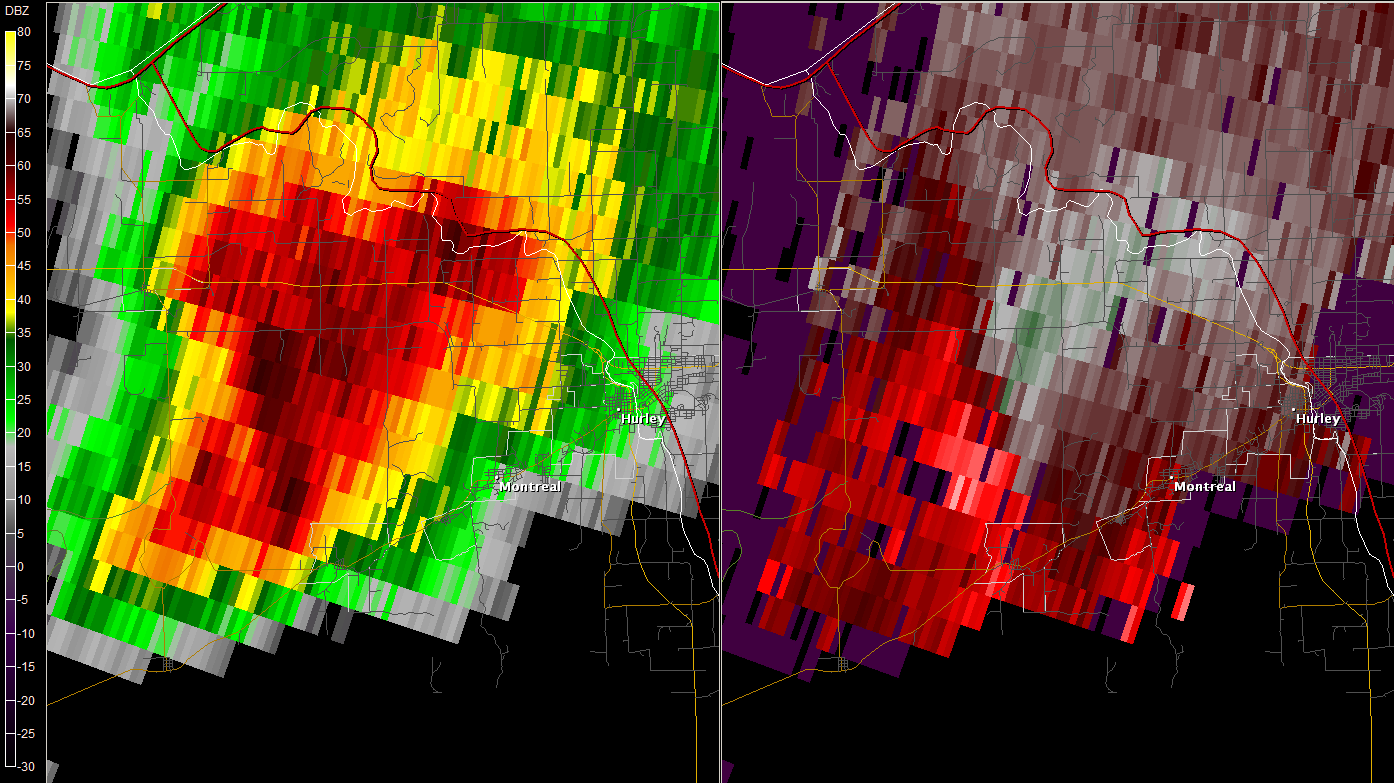
| KDLH Radar image at 6:45 PM CDT zoomed over northern Iron County | KDLH Radar image at 6:54 PM CDT zoomed over Montreal |
Storm Reports
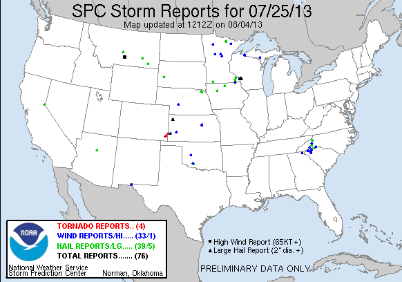
Click the image above for Storm Reports from around the country.
PRELIMINARY LOCAL STORM REPORT...SUMMARY
NATIONAL WEATHER SERVICE DULUTH MN
729 PM CDT THU JUL 25 2013

..TIME...   ...EVENT...      ...CITY LOCATION...     ...LAT.LON...
..DATE...   ....MAG....      ..COUNTY LOCATION..ST.. ...SOURCE....
            ..REMARKS..

0205 PM     HAIL             NETT LAKE               48.11N 93.11W
07/25/2013  M1.00 INCH       KOOCHICHING        MN   TRAINED SPOTTER

            SOME ACCUMULATION

0210 PM     HAIL             3 SSW NETT LAKE         48.07N 93.10W
07/25/2013  E1.00 INCH       KOOCHICHING        MN   PUBLIC

0400 PM     TSTM WND DMG     TOWER                   47.81N 92.29W
07/25/2013                   ST. LOUIS          MN   LAW ENFORCEMENT

            TREES DOWN NEAR TOWER AND AT MCKINLEY PARK. TIME
            ESTIMATED.

0425 PM     HAIL             ALBORN                  46.97N 92.58W
07/25/2013  M0.50 INCH       ST. LOUIS          MN   TRAINED SPOTTER

            40-50 MPH WIND.

0501 PM     TSTM WND DMG     CROSSLAKE               46.68N 94.09W
07/25/2013                   CROW WING          MN   LAW ENFORCEMENT

            10-12 INCH TREE DOWN IN CROSSLAKE VIA CROW WING COUNTY
            SHERIFF.

0508 PM     TSTM WND GST     EMILY                   46.76N 93.96W
07/25/2013  E47.00 MPH       CROW WING          MN   MESONET

            GUST DETECTED ON MESONET AND SAILFLOW.COM

0526 PM     TSTM WND DMG     DEERWOOD                46.47N 93.90W
07/25/2013                   CROW WING          MN   TRAINED SPOTTER

            SMALL TREES KNOCKED DOWN BY WINDS. DIAMETER OF THE TREES
            SIZE OF A SOFTBALL.

0526 PM     HAIL             2 S AITKIN              46.50N 93.71W
07/25/2013  E0.25 INCH       AITKIN             MN   LAW ENFORCEMENT

            DURATION WAS LESS THAN A MINUTE OFF OF 250 ST AND HIGHWAY
            69

0610 PM     HAIL             INTERNATIONAL FALLS     48.59N 93.41W
07/25/2013  E0.88 INCH       KOOCHICHING        MN   PUBLIC

            MOSTLY PEA SIZED HAIL...BUT A FEW NICKEL AND DIME SIZED

0659 PM     HAIL             GILE                    46.43N 90.23W
07/25/2013  E1.00 INCH       IRON               WI   TRAINED SPOTTER

            PEA TO QUARTER SIZED HAIL. 6 INCH DIAMETER TREE DOWN FROM
            THUNDERSTORM WINDS.

0718 PM     HEAVY RAIN       GILE                    46.43N 90.23W
07/25/2013  M1.24 INCH       IRON               WI   CO-OP OBSERVER

            FELL SINCE 430 PM. 1 INCH OF RAIN IN LESS THAN HALF HOUR
            AS STORM MOVED THORUGH.


&&

$$
 |
Media use of NWS Web News Stories is encouraged! Please acknowledge the NWS as the source of any news information accessed from this site. |
|


 Follow us on YouTube