| First Day of Winter Brought Heavy Snow to Much of the Northland | |
|
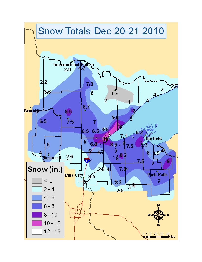
Snow began falling across southern and western Minnesota Monday afternoon, December 20th, 2010. The snow spread northeastward through the evening with the heaviest snow falling during the overnight hours. By Tuesday morning, December 21, widespread snow amounts in the 4 to 8 inch range were observed across northeast Minnesota and northern Wisconsin. Amounts of 8 to 12 inches were common along the north shore of Lake Superior and into the Duluth area. The Borderland region of far northern Minnesota saw the lowest snowfall during this storm with generally around 2 to 5 inches of new snow. |
|
|
|
|
|
The following are final snow amounts from the winter storm that affected the Northland on December 20th and 21st, 2010. Great appreciation is extended to our network of snow spotters and cooperative observers throughout the Northland.
|
|
|
|
INCHES  LOCATION                 ST  COUNTY
 ------  -----------------------  --  --------------
 15.00   ADOLPH                   MN  ST. LOUIS
 13.30   7 NW TWO HARBORS         MN  LAKE
 12.00   3 NW CLOQUET             MN  CARLTON
 11.80   DULUTH                   MN  ST. LOUIS
                 NATIONAL WEATHER SERVICE OFFICE
 11.50   5 W TWO HARBORS          MN  LAKE
 11.00   3 WNW CLAM LAKE          WI  BAYFIELD
 11.00   FINLAND                  MN  LAKE
 11.00   PROCTOR                  MN  ST. LOUIS
 10.80   SILVER BAY               MN  LAKE
 10.20   4 W WASHBURN             WI  BAYFIELD
 10.00   PARK FALLS               WI  PRICE
 10.00   3 WNW CLAM LAKE          WI  BAYFIELD
  9.90   MAPLE                    WI  DOUGLAS
  9.60   BUTTERNUT                WI  ASHLAND
  9.20   WRENSHALL                MN  CARLTON
  9.00   HIGH BRIDGE              WI  ASHLAND
  9.00   MERCER                   WI  IRON
  9.00   5 NW CANYON              MN  ST. LOUIS
  8.90   9 N BAYFIELD             WI  BAYFIELD
  8.60   4 S SAWYER               MN  CARLTON
  8.50   CULVER                   MN  ST. LOUIS
  8.00   1 W WENTWORTH            WI  DOUGLAS
                 AMNICON RIVER VALLEY
  8.00   ASHLAND                  WI  ASHLAND
  8.00   GILE                     WI  IRON
  7.00   7 E WRIGHT               MN  CARLTON
  6.70   CHISHOLM                 MN  ST. LOUIS
  6.50   3 E ORR                  MN  ST. LOUIS
  6.30   8 S HAYWARD              WI  SAWYER
  6.20   4 ENE CORNUCOPIA         WI  BAYFIELD
  6.00   BRUNO                    MN  PINE
  6.00   SAXON                    WI  IRON
  5.60   2 S BRIMSON              MN  ST. LOUIS
  5.50   CASS LAKE                MN  CASS
  5.50   SARONA                   WI  WASHBURN
  5.50   PILLAGER                 MN  CASS
  5.20   7 NW BRAINERD            MN  CROW WING
  4.80   GURNEY                   WI  IRON
  4.70   DANBURY                  WI  BURNETT
  4.60   NORTHOME                 MN  KOOCHICHING
  4.50   3 NE NISSWA              MN  CROW WING
  4.00   EMBARRASS                MN  ST. LOUIS
  3.80   LITTLEFORK               MN  KOOCHICHING
  3.70   ILLGEN CITY              MN  ST. LOUIS
  3.60   INTERNATIONAL FALLS      MN  KOOCHICHING
  3.50   LUTSEN                   MN  COOK
  3.20   12 N ISLE                MN  AITKIN
  3.00   COOK                     MN  ST. LOUIS
  2.50   GRAND PORTAGE            MN  COOK
|
 |
Media use of NWS Web News Stories is encouraged! Please acknowledge the NWS as the source of any news information accessed from this site. |
|


 Follow us on YouTube