| Overview | Radar | Storm Reports |
Photos | Damage Survey |
Additional Resources |
May 3, 2012 Wayland Tornado
In the evening on May 3, 2012, strong storms developed over northern Missouri and central Iowa. These storms quickly became severe as they moved off to the northeast and into southeastern Iowa. One severe storm that moved across northwestern Henry and southeastern Washington counties did go on to produce a tornado.
Around 8:30 pm, the National Weather Service (NWS) Doppler radar indicated a severe storm capable of producing a tornado. The tornado started about one mile south of Wayland, IA and was later rated as an EF2 with estimated wind speeds around 130 mph. More information on the Enhanced-Fujita (EF) scale can be found here. The quarter-mile wide tornado was on the ground for approximately 4.3 miles and lasted around half an hour. There were no reports of any injuries or fatalities with this storm, however, two homes did lose roofs and two turkey farms were destroyed.
The storms continued to march off to the northeast with reports of additional reports of flooding from heavy rains, along with high winds through Muscatine, IA and into the Quad Cities.
Near Wayland, IA
|
|
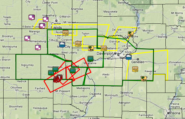
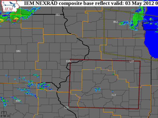
| Radar loop showing severe storms that moved through the area on May 3, 2012. The large dotted red boxes indicate tornado watches and the large yellow boxes are severe thunderstorm watches. Smaller solid red boxes signify tornado warnings and solid yellow boxes are severe thunderstorm warnings. Radar loop courtesy of Iowa Environmental Mesonet. |
| The following pictures represent radar base reflectivity (left panel) and velocity (right panel) during the Wayland tornado. The white circle on the velocity data (right panel) depicts rotation; green indicates winds are going towards the radar and red indicates winds going away from the radar. |
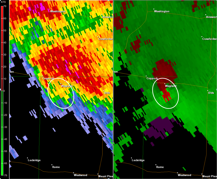 |
| Approximate time: 8:40 pm (CDT) |
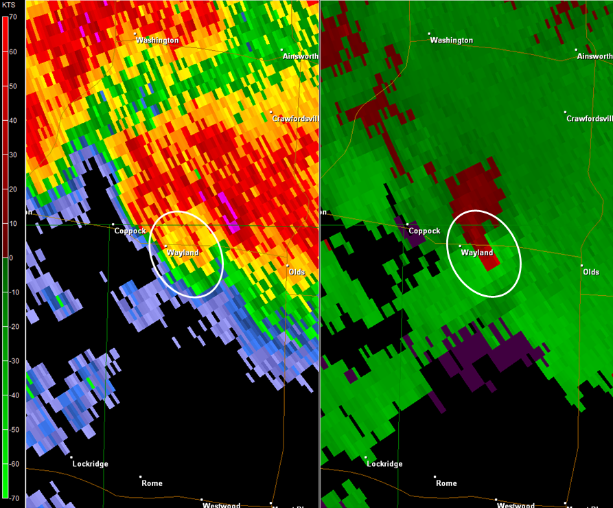 |
| Approximate time: 8:44 pm (CDT) |
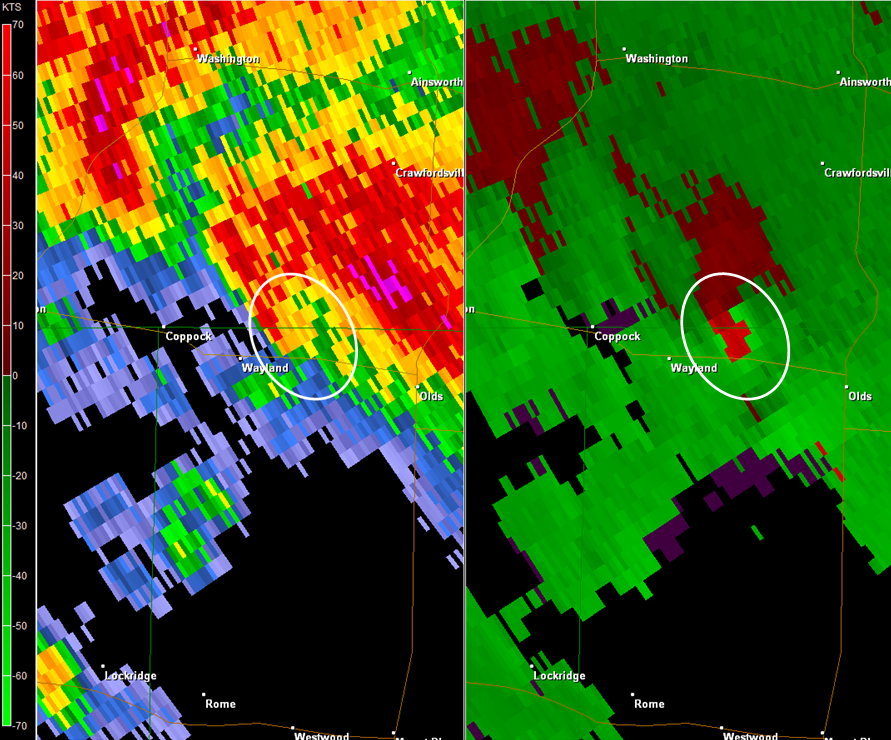 |
| Approximate time: 8:48 pm (CDT) |
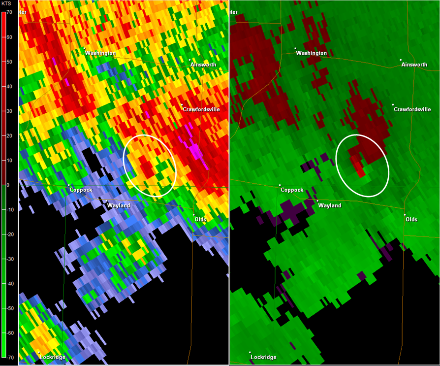 |
| Approximate time: 8:53 pm (CDT) |
 |
| Local storm reports from May 3, along with tornado (red boxes), severe thunderstorm (yellow boxes), and flood warnings (green boxes). Reports courtesy of Iowa Environmental Mesonet. |
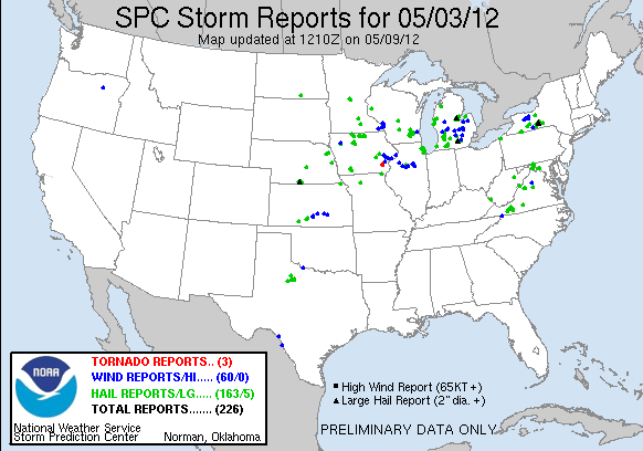 |
| Storm Prediction Center (SPC) national storm reports from May 3. |
Below are photos of the damage that occurred near Wayland, IA. To see a larger image, simply click on the picture. (Photos courtesy of NWS Quad Cities, IA/IL)
.JPG) |
.JPG) |
.JPG) |
.JPG) |
.JPG) |
.JPG) |
.JPG) |
.JPG) |
.JPG) |
.JPG) |
.JPG) |
.JPG) |
.JPG) |
.JPG) |
.JPG) |
.JPG) |
.JPG) |
|
.JPG) |
May 3, 2012 Damage Survey
Public Information Statement (PNS)
000
 NOUS43 KDVN 041954
 PNSDVN
 IAZ040>042-051>054-063>068-076>078-087>089-098-099-ILZ001-002-007-009-
 015>018-024>026-034-035-MOZ009-010-052000-

 PUBLIC INFORMATION STATEMENT
 NATIONAL WEATHER SERVICE QUAD CITIES IA IL
 254 PM CDT FRI MAY 4 2012

 ...STORM SURVEY RESULTS FOR MAY 3 2012 TORNADO...

 TORNADO : HENRY COUNTY IOWA AND WASHINGTON COUNTY IOWA TORNADO
 INFORMATION...

 * LOCATION...APPROXIMATELY 1 MILE SOUTH OF WAYLAND IN HENRY COUNTY
 IOWA...TO 2.25 MILES WEST SOUTHWEST OF CRAWFORDSVILLE IN
 WASHINGTON COUNTY IOWA.
 * TIME...APPROXIMATELY 830 PM CDT TO 900 PM CDT.
 * INJURIES/FATALITIES...NONE.
 * EF-SCALE RATING...HIGH END EF2.
 * ESTIMATED WIND SPEED...130 MPH.
 * MAX WIDTH...1/4 MILE.
 * PATH LENGTH...APPROXIMATELY 4.3 MILES.
 * DAMAGE INFORMATION...THE MOST SIGNIFICANT DAMAGE WAS NOTED NEAR
 THE END OF THE TORNADO PATH. TWO HOMES LOST ROOFS. AT ONE OF
 THE RESIDENCES A CAR WAS TUMBLED. SEVERAL FARMS LOST OUTBUILDINGS.
 2 TURKEY FARMS WERE DESTROYED. A MAIN TRANSMISSION POWER POLE WAS
 ALSO SNAPPED.

 ENHANCED FUJITA /EF/ SCALE INFORMATION...

 PLEASE NOTE THE NUMBERS BELOW ARE APPROXIMATE WIND SPEEDS FOR DAMAGE
 CATEGORIES.

 EF0...  65 -  85 MPH
 EF1...  86 - 110 MPH
 EF2... 111 - 135 MPH
 EF3... 136 - 165 MPH
 EF4... 166 - 200 MPH
 EF5... 201 MPH OR GREATER


 $$

 MCCLURE


 NWS TEAM SURVEYORS...DONNA DUBBERKE AND TIM GROSS.
Additional Resources on the
May 3, 2012 Wayland Tornado
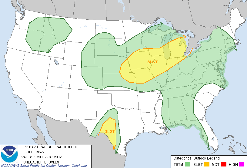 |
| Storm Prediction Center day 1 outlook for May 3, 2012. More information about the outlook can be found here or by clicking on the picture. |
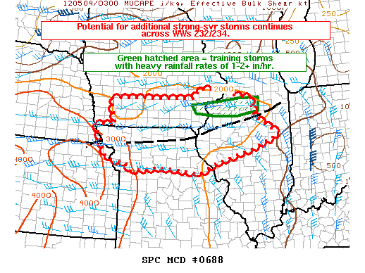 |
| Storm Prediction Center mesoscale discussion for May 3, 2012. More information about the mesoscale discussion can be found here or by clicking on the picture. |
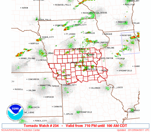 |
| Tornado watch #234 issued on May 3, 2012. More information about the tornado watch can be found here or by clicking on the picture. |


 Follow us on YouTube