November 22, 2010 Severe Weather
A very strong cold front swept across the region during the afternoon of the 22nd, and was accompanied by scattered severe thunderstorms over portions of northeast Missouri, southeast Iowa, and west central and northwest Illinois.
The surface map below at 1800z (12:00 pm CST) shows the potent cold front moving in from the west. Note the nearly 50 degree temperature contrast across the state of Iowa! Unseasonably warm, moist and unstable air was drawn northward ahead of the front on gusty south winds. Moline, Illinois set a new record high for the date at 71 degrees, while many other locations ahead of the front flirted with record highs. This potent cold front along with the unseasonable warmth and strong winds aloft combined to produce conditions favorable for rotating supercell thunderstorms with large hail and tornadoes.

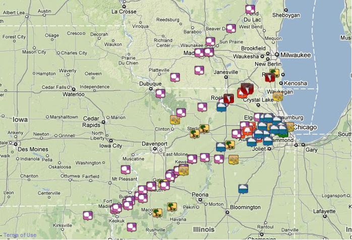
Below is a map of the severe weather reports across the region from the afternoon and evening of the 22nd. 
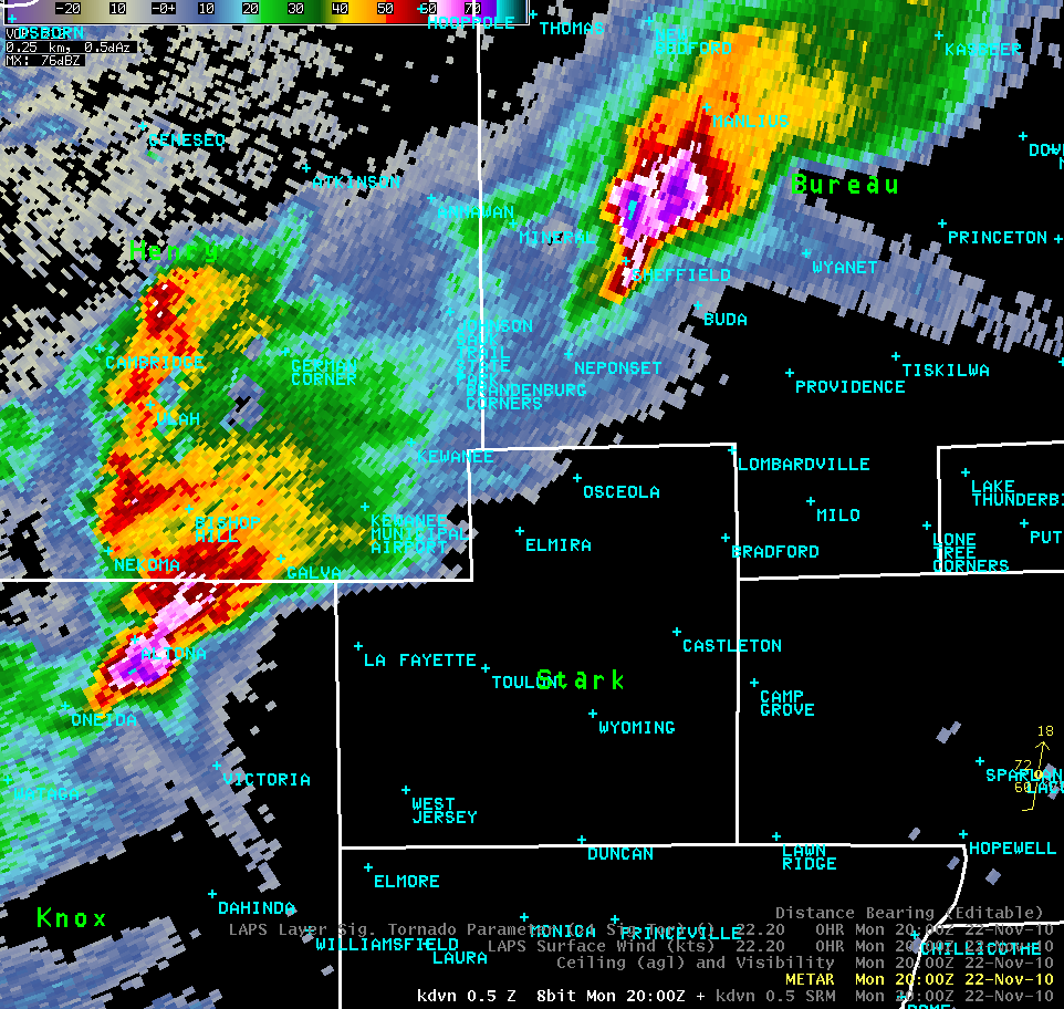
The radar reflectivity image below depicts a pair of supercell thunderstorms at 2000z (2:00 pm CST) . One is located in Knox County near Altona and the second in Bureau County just north of Sheffield. In this image we are looking into the storms at roughly between 2,800 feet and 3,400 feet above ground level (AGL) , with the Quad Cities Doppler Radar located approximately 40-45 miles to the northwest of the storms. The purple and aqua blue shading in the core of the storms show very high levels of reflectivity of 70-76 decibels (dBZ), with values this high often a good indicator of hail. More intriguing, however, is the long "spikes" of reflectivity extending well to the southeast of both storms. These "spikes" are not a reflection of actual precipitation in the area, but rather a classic example of a radar artifact known as a "Three-Body Scatter Spike", or TBSS. The presence of a TBSS almost always indicates that a storm contains large hail. In simple terms, a TBSS is caused by the radar beam hitting the hail aloft, scattering to the ground below, then scattering back upward, and finally being scattered once again by the hail aloft. The 3 scatterings illustrate the triple reflection, thus the term "three-body scatter spike". The combination of large hail and strong winds in these supercells led to some buildings receiving paint damage to west facing walls and to tree bark being scarred from impacts.
.jpg)
Hail damage to the west side of one of the outbuildings.
The second thunderstorm produced significant wind damage in southeastern Henry County shortly after 2000z (2:00 pm CST). A National Weather Service storm damage survey team investigated the damage the following day, and determined that strong straight line winds were responsible.
...Storm survey results for November 22nd in Henry County Illinois...
A severe thunderstorm moved across southeastern Henry County Illinois between 2:00 pm and 2:45 pm monday November 22, 2010. This storm produced a swath of significant straight line wind damage, associated with downdraft winds.
*Location...1 mile south of Galva, Illinois to 3 miles east southeast of Kewanee, Illinois.
*Time...estimated between 2:00 pm and 2:45 pm.
*Estimated maximum wind speed...100 mph.
*Damage...Tree damage was first noted at the Galva Cemetery just south of the county line, where roughly 10 pine trees were either snapped at the base or uprooted. The largest of which was about 2 ft in diameter, and tossed 25 yards to the east. About a dozen of the taller headstones were toppled from their bases. Farther northeast sheet metal was torn from the roof of a Tyson building, and scattered into the surrounding fields a quarter mile to the east. Off of Route 78, southeast of Kewanee, a half dozen pine trees were snapped at the trunk, with surrounding tall grass matted down to the east. Farther down the road to the east a corn crib was destroyed when it shifted off its foundation. Continuing east there were roughly 40 trees in a 35 year old wind break that were snapped at the trunks. Here there was also hail damage noted, with chipped paint on west facing walls and scarred tree trunks. Ending 3 miles east southeast of Kewanee, a barn roof was mostly ripped off, scattering debris a couple hundred yards to the east. Based on the damage, winds were estimated to be between 80 to 100 mph over this stretch of southeastern Henry County Illinois.


 Follow us on YouTube