On the morning of the 18th much of Eastern Iowa, Northwest Illinois and Northeast Missouri saw nearly full sunshine, as decaying thunderstorms from the night before quickly cleared out. In their wake, a strong frontal boundary laid across the region, with a very warm and humid air mass to the south. Meanwhile additional thunderstorm development was under way in Eastern Nebraska early that morning. Sunshine ahead of these storms allowed temperatures to rise into the 80s, with dewpoints well into the 70s. This provided plenty of instability for the storms to feed off of as they moved east into Iowa.
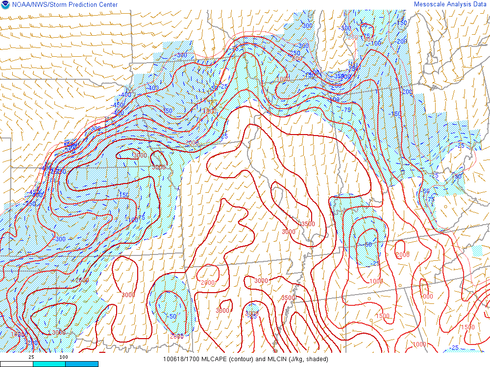
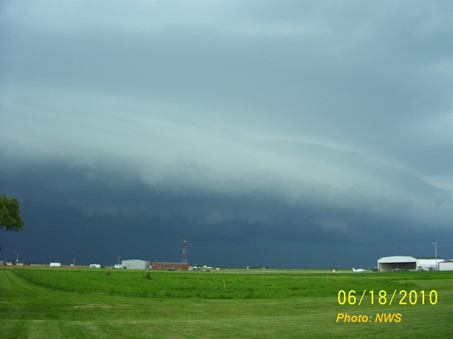
The above image shows mixed layer CAPE (a measure of atmospheric instability) at noon on the 18th, just as the thunderstorms were entering parts of Eastern Iowa and taking on the familiar bow echo shape. The early day sun helped unstable air to surge northward into Eastern Iowa, helping to maintain and strengthen the approaching storms. This unstable air was fuel for strong updrafts, which produced rain and some hail. This precipitation forced into drier mid levels helped to cool the air through evaporation, and in turn this more dense air rushed back towards the surface. Soon 60 to 70mph winds were being reported from Benton County south to Keokuk County. Farther east, the Cedar Rapids Municipal Airport had a measured wind gust to 62mph out of the northwest. As the cold pool behind the bowing line of storms began to strengthen, so did the resulting wind gusts. Jones, Johnson and Cedar Counties experienced numerous wind gusts of 70mph or greater, which resulted in widespread tree damage and downed power line due to falling limbs. The bow continued to develop, but struggled to push any further south than I-80. Below is an image of the shelf cloud as it approached the Quad Cities forecast office, shortly before a 46 knot peak gust recorded by the wind equipment.
East of the Mississippi River the bowing line began to strengthen further as it left the eastern end of Bureau County. Parts of northern Illinois experienced 70 to 80mph winds, and windows were blown out of skyscrapers in Chicago. The line of thunderstorms pushed across parts of Lake Michigan and produced 70mph on the eastern shore, and continued to produce wind damage all the way into Ohio.
Following this line of storms, clouds cleared quickly north of I-80, while areas to the south had already been relatively cloud free for most the day. Temperatures across Southern Iowa were now near 90 degrees, with dewpoints remaining in the 70s, building another large reservoir of unstable air. A new batch of storms began to fire along the Highway 20 corridor in Central Iowa, with hail up to the size of golf balls being reported by trained weather spotters. Along the edge of the greatest instability one lone supercell was able to form, and produced a brief tornado south of Des Moines.
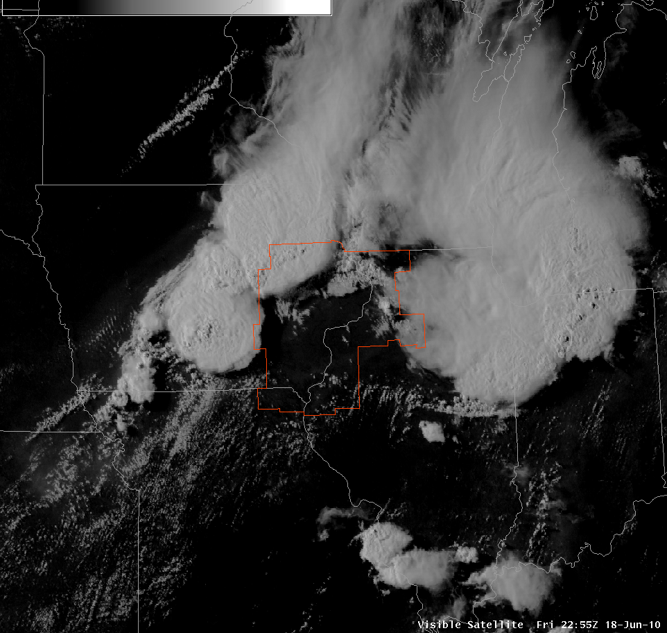
Above: Visible satellite shortly before 6pm, showing the departing first line of thunderstorms and the developing second, with a large area of sunny skies between.
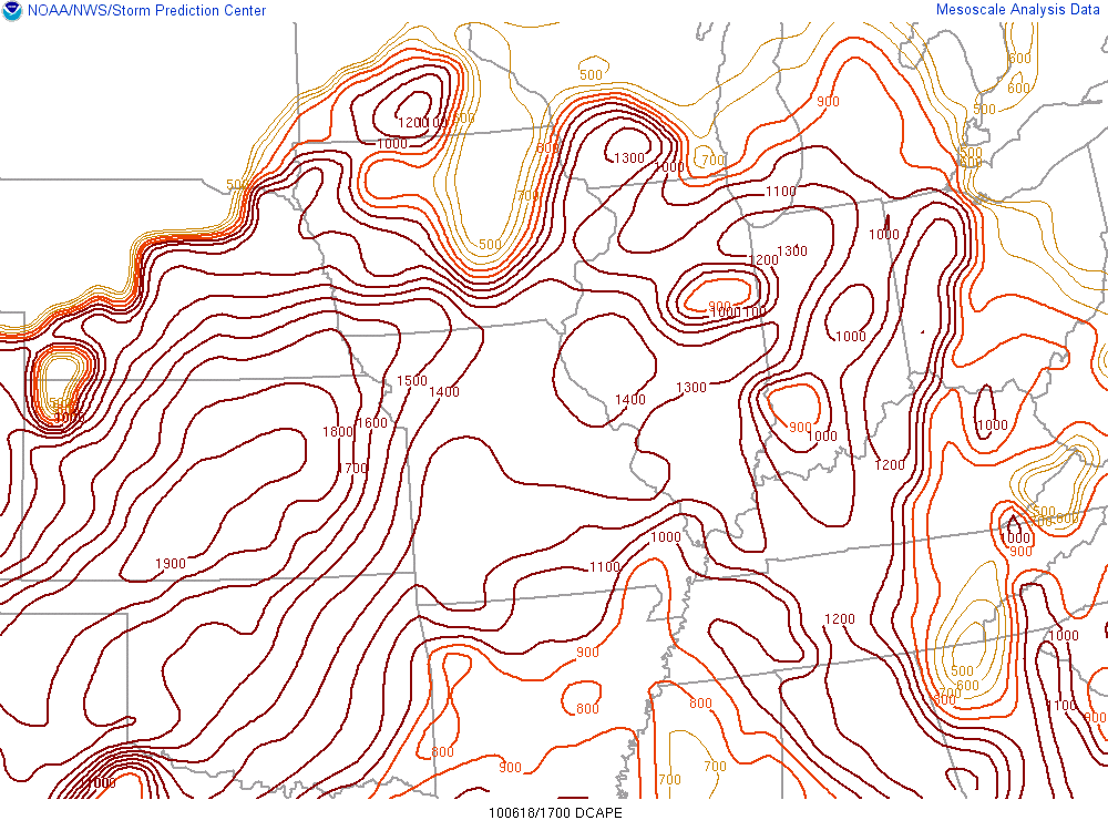
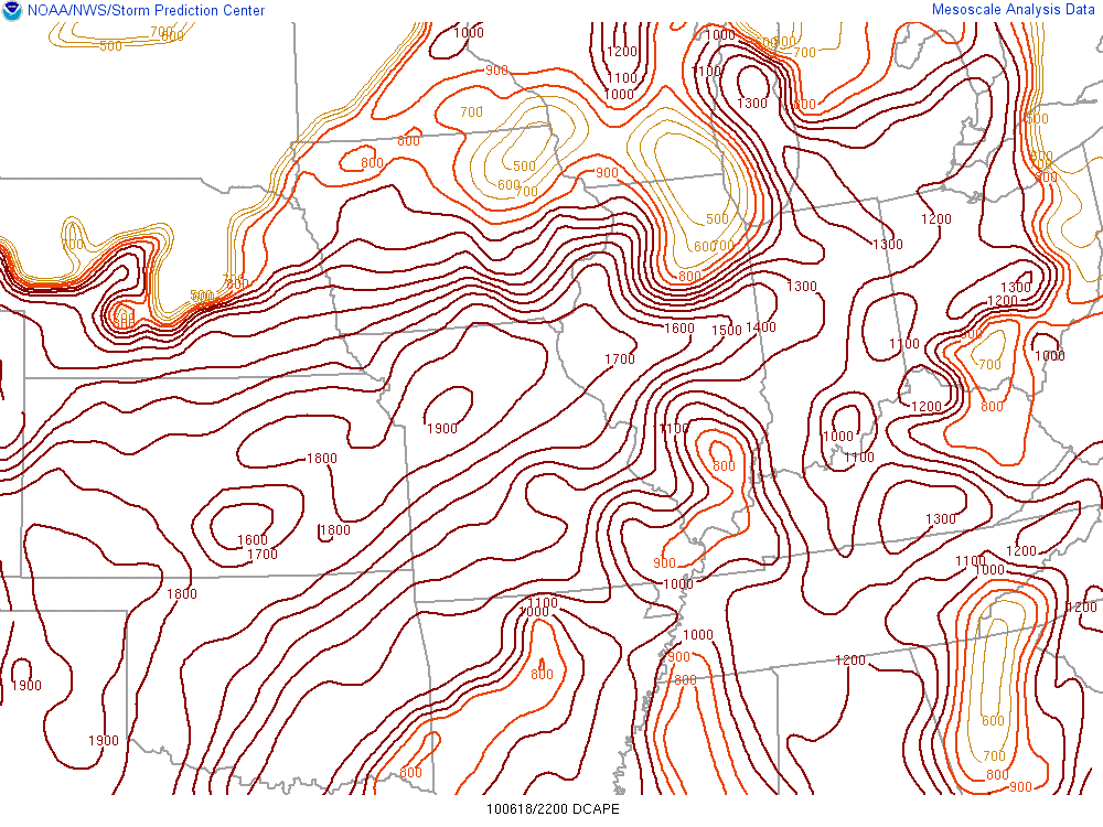
However, these storms quickly congealed into another line that began to pivot southeastward into Eastern Iowa. Despite it only being a few hours after the first round of storms, the atmosphere had quickly recovered enough that the second storms were able to rapidly develop severe characteristics. Below are two images of DCAPE, or a measure of the atmosphere's ability to produce cold outflow air responsible for the high winds. Just like CAPE, the higher the number the greater the potential for severe weather. This first image is from noon, just before the first line of thunderstorms, and the second is from 5pm, just before the second line. The values of DCAPE are quite high at noon (indicating a strong potential for damaging winds) but at 5pm there is a reservoir of even higher DCAPE values feeding in ahead of the second line.
Along the developing line a bowing segment developed in Northern Linn County, that raced into Jones, Northern Cedar and Scott, and Western Clinton Counties.
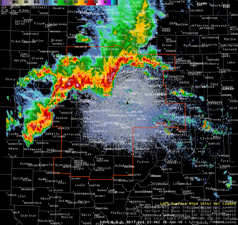
Above: Radar reflectivity showing multiple bowing segments within the larger line of thunderstorms.
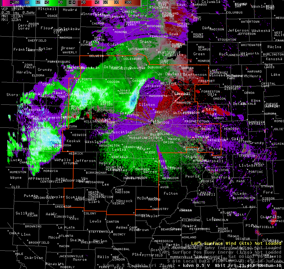
Above: Radar measured wind velocity. Blue area in the center of the image shows winds approaching 100 knots above the surface about to enter Western Clinton County.
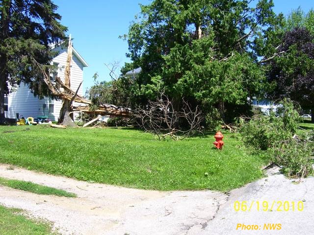
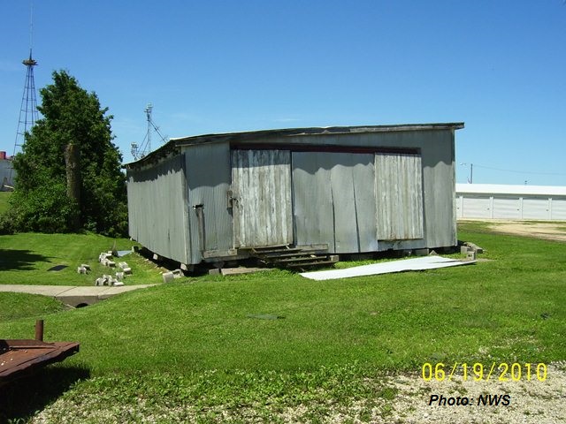
At times the National Weather Service radar sampled nearly 100 knot winds with this bow echo at around 2000 feet. Some of this occurred near the Lost Nation area, where a National Weather Service storm survey team investigated the damage on the 19th. Here snapped trees and roof damage to some outbuildings (one of which was moved off its foundation) indicated straight line wind speeds near 90mph (see images below).
The thunderstorms continued across the Mississippi River, following more or less the same path as the storms earlier in the day. Here there was report of a tornado between Port Byron and Hillsdale, Illinois, however the storm survey team was unable to find any damage consistent with a tornado track. The survey team was able to find scattered damage to trees that was supportive of straight line wind speed approaching 80mph. As the squall line traveled farther east, it encountered more worked over air from the first storms of the day, and as a result began to lose severe characteristics. Instead it began to lay out east to west, and heavy rain became the main threat.


 Follow us on YouTube