Overview
|
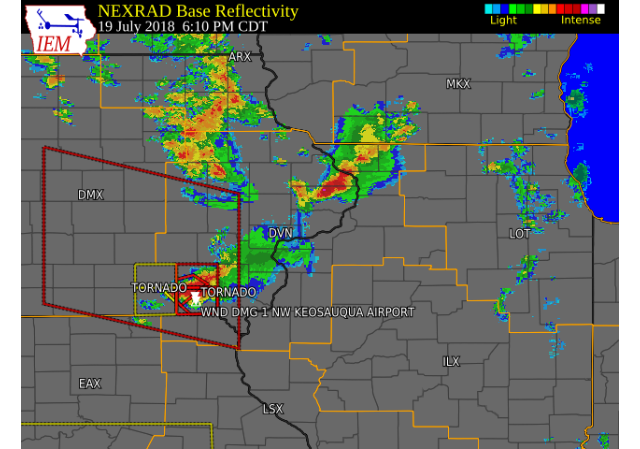
A cold front progressing across central Iowa helped produced showers and thunderstorms across much of the region this afternoon and evening. Thunderstorms became severe across southeast Iowa, west central Illinois, and northeast Missouri, and produced tornadoes, winds up to 80 MPH, hail up to golf ball size, and heavy rainfall amounts over 1 inch. Damage to trees and power lines were reported from Van Buren to Clark and Hancock counties. A damage survey team found two EF-1 tornadoes touched down north of Keosauqua in Van Buren County as storms moved through. Please see the Tornado tab below for additional details.
|
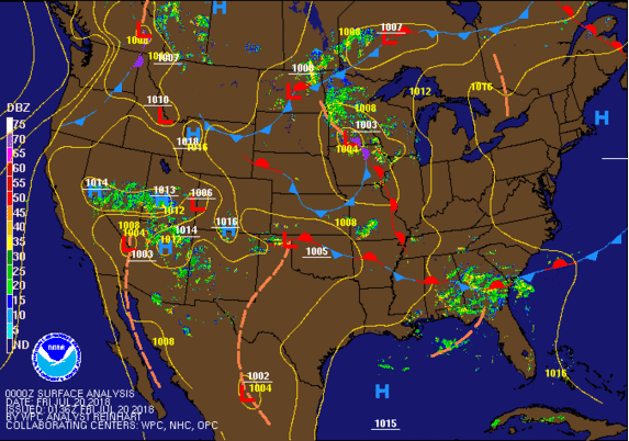 Weather Prediction Center Pressure / Fronts |
Tornado:
|
Tornado #1 - 1.2 NNE Keosauqua, IA
Track Map 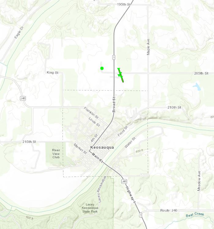 
|
||||||||||||||||
|
Tornado #2 - 4.9 N Keosauqua, IA
Track Map 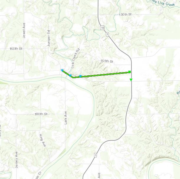
|
||||||||||||||||
The Enhanced Fujita (EF) Scale classifies tornadoes into the following categories:
| EF0 Weak 65-85 mph |
EF1 Moderate 86-110 mph |
EF2 Significant 111-135 mph |
EF3 Severe 136-165 mph |
EF4 Extreme 166-200 mph |
EF5 Catastrophic 200+ mph |
 |
|||||
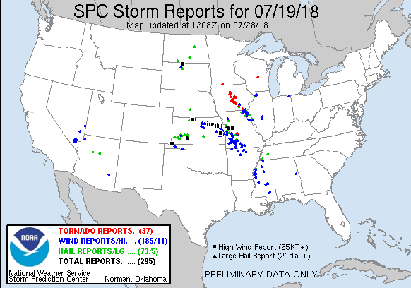
Storm Reports
| Interactive Storm Map | SPC Storm Reports |
 |
 |
PRELIMINARY LOCAL STORM REPORT...SUMMARY
NATIONAL WEATHER SERVICE QUAD CITIES IA IL
916 PM CDT THU JUL 19 2018

..TIME...   ...EVENT...      ...CITY LOCATION...     ...LAT.LON...
..DATE...   ....MAG....      ..COUNTY LOCATION..ST.. ...SOURCE....
            ..REMARKS..

0905 PM     HEAVY RAIN       KEOSAUQUA               40.74N 91.96W
07/19/2018  M1.10 INCH       VAN BUREN          IA   TRAINED SPOTTER

            TOTAL RAINFALL AS OF 9PM.

0834 PM     HEAVY RAIN       3 W INDIAN LAKE PARK    40.64N 91.80W
07/19/2018  M2.10 INCH       VAN BUREN          IA   TRAINED SPOTTER

            STORM TOTAL SO FAR.

0818 PM     HAIL             2 N KAHOKA              40.46N 91.72W
07/19/2018  E0.25 INCH       CLARK              MO   TRAINED SPOTTER

            PEA HAIL OCCURRING RIGHT NOW.

0808 PM     TSTM WND DMG     WYACONDA                40.39N 91.92W
07/19/2018                   CLARK              MO   LAW ENFORCEMENT

            TREE DOWN IN WYACONDA ON RTE A.

0758 PM     TSTM WND GST     SHANNON                 42.15N 89.74W
07/19/2018  M60 MPH          CARROLL            IL   TRAINED SPOTTER


0740 PM     TSTM WND GST     LANARK                  42.11N 89.83W
07/19/2018  E60 MPH          CARROLL            IL   TRAINED SPOTTER

            DELAYED REPORT AND TIME ESTIMATED FROM
            RADAR.

0738 PM     TSTM WND DMG     ALEXANDRIA              40.36N 91.46W
07/19/2018                   CLARK              MO   LAW ENFORCEMENT

            TREES DOWN.

0730 PM     HAIL             1 NNW MOUNT CARROLL     42.10N 89.98W
07/19/2018  E1.00 INCH       CARROLL            IL   TRAINED SPOTTER


0727 PM     HAIL             SOUTH GORIN             40.36N 92.02W
07/19/2018  M1.75 INCH       SCOTLAND           MO   FIRE DEPT/RESCUE

            REPORTED FROM GORIN FIRE DEPARTMENT.

0723 PM     HAIL             SOUTH GORIN             40.36N 92.02W
07/19/2018  M1.75 INCH       SCOTLAND           MO   911 CALL CENTER

            RELAYED REPORT FROM CLARK CO., MO DISPATCH.

0719 PM     HAIL             KEOKUK                  40.41N 91.40W
07/19/2018  M1.00 INCH       LEE                IA   TRAINED SPOTTER


0718 PM     HAIL             WARSAW                  40.36N 91.43W
07/19/2018  E1.00 INCH       HANCOCK            IL   BROADCAST MEDIA

            DELAYED REPORT AND TIME ESTIMATED FROM
            RADAR.

0718 PM     TSTM WND DMG     WARSAW                  40.36N 91.43W
07/19/2018                   HANCOCK            IL   BROADCAST MEDIA

            DELAYED REPORT AND TIME ESTIMATED FROM
            RADAR. NUMEROUS TREES DOWN IN TOWN.

0717 PM     HAIL             SOUTH GORIN             40.36N 92.02W
07/19/2018  M1.00 INCH       SCOTLAND           MO   FIRE DEPT/RESCUE

            QUARTER SIZE HAIL FALLING AT THE GORIN FIRE
            DEPARTMENT.

0715 PM     TSTM WND DMG     MOOAR                   40.44N 91.45W
07/19/2018                   LEE                IA   PUBLIC

            CORRECTS PREVIOUS TSTM WND DMG REPORT FROM
            MOOAR. SEVERAL TREES AND LARGE TREE BRANCHES
            DOWN AT KEOKUK HIGH SCHOOL. TIME ESTIMATED
            BY RADAR.

0715 PM     TSTM WND GST     KEOKUK AIRPORT          40.46N 91.43W
07/19/2018  M56 MPH          LEE                IA   PUBLIC

            AWOS MEASURED WIND.

0715 PM     TSTM WND GST     SAVANNA RIVERVIEW AIRPO 42.05N 90.11W
07/19/2018  M50 MPH          CARROLL            IL   PUBLIC

            AWOS MEASURED WIND.

0712 PM     HEAVY RAIN       JESUP                   42.48N 92.07W
07/19/2018  M1.72 INCH       BUCHANAN           IA   TRAINED SPOTTER

            STORM TOTAL.

0710 PM     HAIL             3 SSE MEMPHIS           40.42N 92.14W
07/19/2018  E1.25 INCH       SCOTLAND           MO   TRAINED SPOTTER

            DELAYED REPORT AND TIME ESTIMATED FROM
            RADAR.

0658 PM     HAIL             MEMPHIS                 40.46N 92.17W
07/19/2018  M0.88 INCH       SCOTLAND           MO   TRAINED SPOTTER


0656 PM     HAIL             3 WNW MOUNT STERLING    40.64N 91.98W
07/19/2018  E0.25 INCH       VAN BUREN          IA   TRAINED SPOTTER

            PEA HAIL AND WINDS GUSTING TO 40 MPH WITH
            HEAVY RAIN OCCURRING RIGHT NOW.

0654 PM     HAIL             ARGYLE                  40.53N 91.57W
07/19/2018  E0.88 INCH       LEE                IA   TRAINED SPOTTER

            NICKEL HAIL. NOT SURE IF IT WAS LARGER OR
            NOT.

0650 PM     TSTM WND GST     5 N KAHOKA              40.50N 91.72W
07/19/2018  E60 MPH          CLARK              MO   LAW ENFORCEMENT


0650 PM     TSTM WND DMG     1 NW FROST ISLAND CA    40.45N 91.57W
07/19/2018                   CLARK              MO   EMERGENCY MNGR

            REPORT OF POWER LINES DOWN WITH TREE
            BRANCHES IN ST. FRANCISVILLE, MO. TIME
            ESTIMATED BASED ON RADAR.

0643 PM     TSTM WND DMG     DONNELLSON              40.64N 91.57W
07/19/2018                   LEE                IA   TRAINED SPOTTER

            DELAYED REPORT AND TIME ESTIMATED FROM
            RADAR. NUMEROUS TREES AND POWER LINES DOWN
            IN TOWN.

0642 PM     TSTM WND GST     3 ENE CHARLIE HEATH MEM 40.59N 91.84W
07/19/2018  E60 MPH          CLARK              MO   TRAINED SPOTTER


0639 PM     TSTM WND DMG     CROTON                  40.59N 91.68W
07/19/2018                   LEE                IA   TRAINED SPOTTER

            DELAYED REPORT AND TIME ESTIMATED FROM
            RADAR. NUMEROUS TREES DOWN.

0638 PM     HAIL             1 ESE LACEY KEOSAUQUA S 40.71N 91.96W
07/19/2018  E0.75 INCH       VAN BUREN          IA   BROADCAST MEDIA

            DIME SIZED HAIL.

0634 PM     TSTM WND DMG     FARMINGTON              40.64N 91.74W
07/19/2018                   VAN BUREN          IA   BROADCAST MEDIA

            DELAYED REPORT AND TIME ESTIMATED FROM
            RADAR. NUMEROUS LARGE OAK TREES DOWN IN
            TOWN. ROOF OF BUILDING PEELED BACK.

0634 PM     TSTM WND DMG     2 N ANSON               40.60N 91.77W
07/19/2018                   CLARK              MO   BROADCAST MEDIA

            DELAYED REPORT. LARGE TREE DOWN, SEVERAL
            FEET IN DIAMETER, AT MISSOURI HIGHWAY 81 AND
            COUNTY V.

0630 PM     TSTM WND GST     3 ENE CHARLIE HEATH MEM 40.59N 91.84W
07/19/2018  E50 MPH          CLARK              MO   TRAINED SPOTTER

            VISIBILITY 1/8 MILE IN HEAVY RAIN.

0630 PM     TSTM WND DMG     3 W INDIAN LAKE PARK    40.64N 91.81W
07/19/2018                   VAN BUREN          IA   TRAINED SPOTTER

            DELAYED REPORT AND TIME ESTIMATED FROM
            RADAR. THREE OUTBUILDINGS DOWN ON PROPERTY.

0609 PM     TSTM WND DMG     1 NW KEOSAUQUA AIRPORT  40.75N 91.96W
07/19/2018                   VAN BUREN          IA   EMERGENCY MNGR

            DELAYED REPORT AND TIME ESTIMATED FROM
            RADAR. CONSIDERABLE DAMAGE TO BUILDINGS AT
            THE FAIRGROUNDS. GAS PUMPS BLOWN OVER AND A
            BUILDING DAMAGED AT A COUNTY FACILITY NEXT
            TO THE FAIRGROUNDS.

0510 PM     TSTM WND GST     6 NW HEDRICK            41.23N 92.39W
07/19/2018  E70 MPH          KEOKUK             IA   LAW ENFORCEMENT

            AT LEAST 70 MPH.

0445 PM     HAIL             WYOMING                 42.06N 91.00W
07/19/2018  E0.75 INCH       JONES              IA   TRAINED SPOTTER

            STONES UP TO PENNIES, WINDS TO 40 MPH.

0410 PM     HAIL             3 SSW CENTER JUNCTION   42.08N 91.11W
07/19/2018  E0.88 INCH       JONES              IA   TRAINED SPOTTER
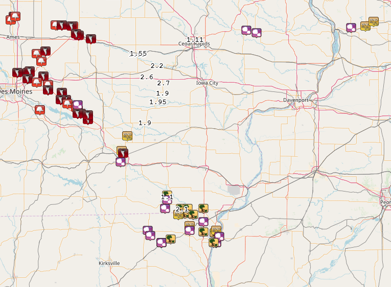
Rain Reports
More information will be added by 10 AM Thursday, July 20th
 |
 |
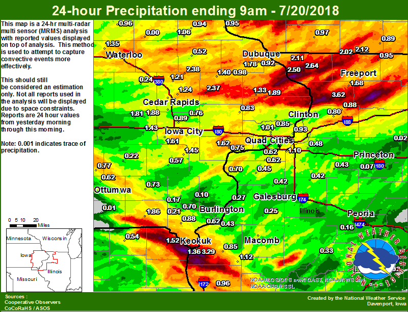
| Figure 1: Local 24-hr Rainfall ending 9 am 7/20 |
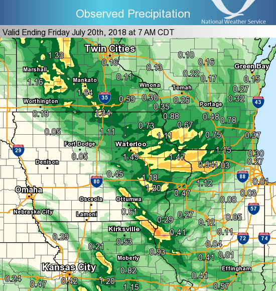
Figure 2: Regional Rainfall Ending 7am 7/20 |
24 hour precipitation reports (in Inches),
for eastern Iowa, northwest and west central Illinois,
and northeast Missouri. Reported between Midnight and 9 AM,
Friday July 20, 2018.

....IOWA....
Bellevue LD12                    2.50
Coggon                           2.38
Anamosa 3 SSW                    2.37
Mason City* 0 E                  2.15
Mason City 1 NNE                 2.02
Delmar 2.3 NW                    1.89
Amana 4.7 W                      1.88
Keosauqua                        1.86
Dubuque LD11                     1.85
Marengo                          1.81
Peosta 2.9 E                     1.78
Oskaloosa 1 NNW                  1.77
Muscatine 2N                     1.62
Kalona 7.3 NNW                   1.61
Dubuque #3 7 SW                  1.46
Ainsworth 7.4 N                  1.45
Williamsburg                     1.43
Monticello 1 E                   1.40
Cedar Rapids 3.4 NW              1.39
Keokuk LD19                      1.36
Iowa City Arpt                   1.35
Waterloo ASOS 5 NW               1.35
Maquoketa 4W                     1.33
Mason City ASOS 6 W              1.28
Hampton 1 N                      1.27
Marion 1.7 NNW                   1.24
Central City 6.7 W               1.21
Cedar Rapids 2.7 NE              1.19
Le Claire LD14                   1.13
Strawberry Point                 1.06
Eldridge 0.7 SSW                 1.01
Iowa City                        1.01
Cascade                          0.98
Toledo 3 N                       0.97
Tripoli 0 N                      0.96
Guttenberg Dam 10                0.95
Elkader 6SSW                     0.94
Le Claire 1.8 NNE                0.93
Dubuque Arpt 7 SW                0.92
North Liberty 1.0 ENE            0.89
Donnellson                       0.88
Bettendorf 1.6 WSW               0.86
Park View 0.2 WSW                0.85
Lowden                           0.83
Cedar Rapids Arpt 5 SW           0.79
Oskaloosa AWOS 9 ESE             0.77
Burlington 2S                    0.76
Solon 0.3 ESE                    0.76
Bettendorf 2.2 SE                0.75
Davenport 0.9 WNW                0.73
Fairfield                        0.73
Davenport Arpt 5 N               0.70
West Point 7.5 NW                0.70
Burlington Arpt 2 SW             0.69
Davenport 0.9 SSW                0.65
Burlington 6.5 SSW               0.62
Ottumwa ASOS 6 NNW               0.62
Washington                       0.57
Cresco 1 NE                      0.52
Manchester                       0.52
Mt Pleasant 1 SSW                0.50
Brighton                         0.50
Marshalltown 1 NW                0.50
Grinnell 2 SW                    0.40
Grinnell AWOS 2 SSW              0.35
Vinton                           0.24
Sigourney                        0.22
Salem 1S                         0.21
Salem 3.1 ESE                    0.17
New London 1.5 SW                0.10
Ames US 30 2 SSE                 0.01
Pella 4 N                        0.01
Bloomfield 1 NW                  0.01
Perry 0 W                        0.00
Beaconsfield 1 NNE               0.00
Centerville 0 NE                 0.00
NWS Johnston* 5 NNW              0.00
Oelwein AWOS                     0.00
Boone 1 SSW                      0.00
Pella AWOS 2 WSW                 0.00
Rathbun Reservoir 2 N            0.00
....ILLINOIS....
Chadwick 2.7 WSW                 3.62
Warsaw 5.8 SE                    3.29
Elizabeth                        2.64
Orangeville 2.8 NW               2.12
Galena                           2.11
Winslow 4.3 ESE                  2.02
Pearl City 0.4 SW                1.74
Shannon 0.2 S                    1.68
Rockford ASOS                    1.20
Quad City Arpt 3 S               1.19
Augusta                          1.12
Coal Valley 1.9 SE               1.10
Roscoe 2SE                       0.99
Quincy ASOS                      0.96
Davis 0.5 N                      0.95
Coleta 1.4 SSW                   0.88
Bentley                          0.85
Moline 0.7 NNE                   0.83
Moline 0.9 N                     0.81
Freeport                         0.81
Morrison 3.2 E                   0.80
Ill. City LD16 3 WNW             0.75
Freeport 2.0 NW                  0.71
New Boston LD17                  0.70
Milan 8.8 SSW                    0.62
Moline 1.0 WNW                   0.62
Macomb 3.8 NW                    0.58
Rochelle                         0.55
Geneseo 2.0 NW                   0.48
Colchester 3.5 NE                0.48
Aledo                            0.45
Kewanee 1 E                      0.43
Dallas City 3.0 SSE              0.43
Alexis 1 SW                      0.42
Altona                           0.42
Rochelle AWOS                    0.37
Havana                           0.33
Gladstone LD18                   0.27
Steward                          0.25
Roseville 0.6 WNW                0.25
Galesburg                        0.24
Mundelein                        0.23
Galesburg Arpt 3 SW              0.23
Macomb                           0.20
Peoria ASOS                      0.16
Jacksonville AWOS                0.10
Tiskilwa 2.1 N                   0.07
Windsor                          0.06
Paw Paw 1 E                      0.06
Romeoville                       0.04
Princeton 1.1 SE                 0.03
Princeton                        0.03
Bloomington Airport              0.03
Mendota 2 SE                     0.02
Lincoln NWS                      0.02
Ottawa 4 SW                      0.00
Decatur Airport                  0.00
Ogden                            0.00
Streator 3 SE                    0.00
Joliet                           0.00
Tuscola                          0.00
....MISSOURI....
Chillicothe 2 NW                 1.89
Kahoka 0.6 S                     1.52
Columbia                         1.11
Memphis                          0.54
Kirksville ASOS                  0.50
....WISCONSIN....
Beloit-College                   1.01
Darlington                       0.97
Prairie du Chien AWOS            0.96
Brodhead 1 SW                    0.89
Madison-ASOS                     0.79
Allenton-WWTP .6 NW              0.77
Viroqua                          0.75
Delavan-1 W-WWTP 1 W             0.73
La Crosse WFO                    0.28
Watertown-AWOS                   0.11
....MINNESOTA....
Preston                          0.59
Photos
 |
 |
 |
 |
|
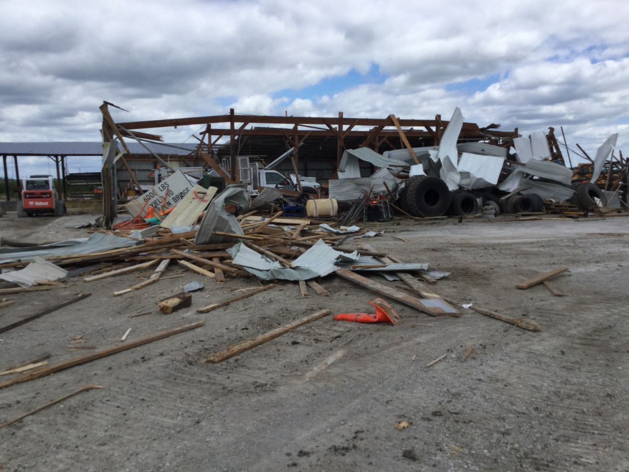
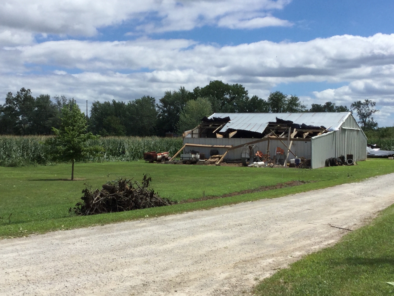
Lumber yard building damage |
Tornado Damage ~5 N Keosauqua, IA (NWS Damage Survey) |
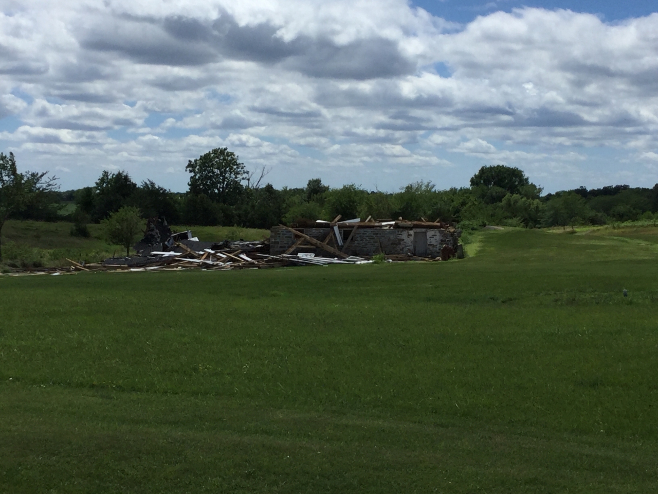
Destroyed historic stone barn ~5 N Keosauqua, IA (NWS Damage Survey) |
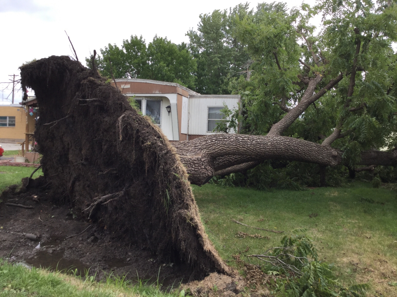
Uprooted tree in Donnellson due to straight-line winds (NWS Damage Survey) |
 |
Media use of NWS Web News Stories is encouraged! Please acknowledge the NWS as the source of any news information accessed from this site. |
|


 Follow us on YouTube