National Weather Service United States Department of Commerce

May 4, 2003 Radar and Damage Photos

Below is a collection of Radar, Damage, and Tornado pictures from the May 4, 2003 tornadic event.


   Various Tornado Pictures
 South of Basehor, KS  I-70 & I-435 (Kansas) looking Northeast  Kansas City, KS
 Bonner Springs, KS looking Northwest  Liberty, MO  Southwest of Knob Noster, MO
 Highway 2 & Highway 131 Johnson County, MO  Damage in Kansas City, KS  Various Locations across Leavenworth, Platte, and Clay Counties


Radar Imagery


Tornado Outbreak - May 4, 2003
Radar image of tornadic supercell over Clay County Missouri  05-04-2003 4:44pm Radar image of tornadic supercell over Clay County Missouri  05-04-2003 4:59pm
Radar images of tornadic supercell over Clay County Missouri, just north-northeast of downtown Kansas City
Radar image of tornadic supercell over Cass/Johnson County Missouri  05-04-2003 6:14pm Radar image of tornadic supercell over Johnson County Missouri  05-04-2003 6:48pm
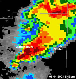
Radar images of tornadic supercell in Cass and Johnson Counties in Missouri


Tornado Damage Photos


Tornado Damage Tornado Damage

Tornado Damage

Click on the Image for Larger Versions


Various Tornado Pictures


Tornado Outbreak - May 4, 2003 - South of Basehor, KS
The images below were taken by Christina Frazier on May 4, 2003 south of Basehor, KS

Tornado south of Basehor, KS Tornado south of Basehor, KS Tornado south of Basehor, KS
Tornado south of Basehor, KS    


 Tornado Outbreak - May 4, 2003 - Intersection of I-70 and I-435 (Kansas) looking northeast


The images of a tornado below were taken by Jason Earnhart on May 4, 2003 near the intersection of Interstate 70 and Interstate 435 looking northeast.

Tornado looking northeast from intersection of Interstate 70 and Interstate 435 (Kansas) Tornado looking northeast from intersection of Interstate 70 and Interstate 435 (Kansas) Tornado looking northeast from intersection of Interstate 70 and Interstate 435 (Kansas)


Tornado Outbreak - May 4, 2003 - Kansas City, KS

The images of a tornado below were taken by Andrew Revering on May 4, 2003 near the intersection of Interstate 70 and 110th street looking north northeast.
Tornado in Kansas City, KS Tornado in Kansas City, KS Tornado in Kansas City, KS
 
 
Tornado Outbreak - May 4, 2003 - from Bonner Springs looking northwest


The images below were taken by Jeff Manion on May 4, 2003 from Bonner Springs, KS looking northwest.

Tornado from Bonner Springs looking northwest Tornado from Bonner Springs looking northwest Tornado from Bonner Springs looking northwest


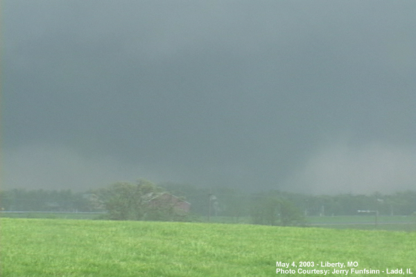
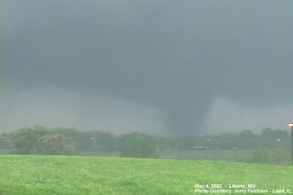
Tornado Outbreak - May 4, 2003 - Liberty, MO

The images of a tornado below were taken by Jerry Funfsinn of Ladd, IL on May 4, 2003 in Liberty, MO.

Tornado in Liberty, MO Tornado in Liberty, MO


Tornado Outbreak - May 4, 2003 - Southwest of Knob Noster, MO

The images below were taken by Dave Ewoldt on May 4, 2003 southwest of Knob Noster, MO
Image southwest of Knob Noster, MO Image southwest of Knob Noster, MO Image southwest of Knob Noster, MO
 

Tornado Outbreak - May 4, 2003 - near Intersection of Highway 2 & Highway 131

The images of a tornado below were taken by Dan Hinch on May 4, 2003 near the intersection of Highway 2 and Highway 131 in Johnson County Missouri.

Tornado near intersection of Highway 2 and Highway 131 in Johnson County Missouri Tornado near intersection of Highway 2 and Highway 131 in Johnson County Missouri Tornado near intersection of Highway 2 and Highway 131 in Johnson County Missouri
Tornado near intersection of Highway 2 and Highway 131 in Johnson County Missouri Tornado near intersection of Highway 2 and Highway 131 in Johnson County Missouri  


Tornado Outbreak - May 4, 2003 - Kansas City, KS

The images of tornado damage were taken by Jennifer Combs in the vicinity of 77th and Cernech Rd. in Kansas City, KS. The first image was taken on May 4 about an hour after the tornado hit. The last two pictures were taken on May 6.

Damage in Kansas City, KS Damage in Kansas City, KS Damage in Kansas City, KS


Tornado Outbreak - May 4, 2003 - Leavenworth County - Platte County - Clay County

The images of a tornado below were taken by Ben Alonzo on May 4, 2003 at various locations where it tracked through Leavenworth County, KS; Platte County, MO; and Clay County, MO

Tornado in Northern Kansas City Metro Tornado in Northern Kansas City Metro Tornado in Northern Kansas City Metro
Tornado in Northern Kansas City Metro Tornado in Northern Kansas City Metro