Individual Breakdown
of the Feb 19-20, 2017 Tornadoes
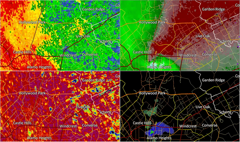
| Ridgeview/Alamo Heights Tornado (Bexar County) |
| # |
Rating |
Max Winds |
Time (LST) |
Start |
End |
Length |
Width |
Fatalities |
Injuries |
| 1 |
EF2 |
120 MPH |
2236-2243 |
29.4907/-98.4991 |
29.5154/-98.4273 |
4.6 mi |
600 yds |
0 |
? |
A tornado formed near San Pedro Avenue at the San Pedro Golf course and moved northeast while
strengthening to an EF-1 near Jackson-Keller Road.  As it got to Linda Drive is strengthened and
the damage path was its widest at near 600 yards.  The tornado took a bit of a right turn and
moved due east along Linda and Sharon Drives where it had peak winds of near 120 mph making it
an EF-2 Tornado. A few homes in this area had their roofs completely removed.  The tornado
crossed Highway 281 near the Alamo Quary Market shopping center as an EF-1 and continued on and
East-Northeast track through Alamo Heights.  Along its path numerous homes had roof damage
and major tree damage with large oak trees snapped and uprooted.  The rest of the track was
mainly EF-0 wind speeds but with a few smaller pockets of EF-1 damage.  The tornado crossed near
the Nacogdoches/New Braunfels Ave. intersection, moved east-northeast, crossing Harry Wurzbach
and finally dissipating near the Loop 410/Salado Creek area.

(Official Public Information Statement) (Click to Return to Main Page)
 |
 |
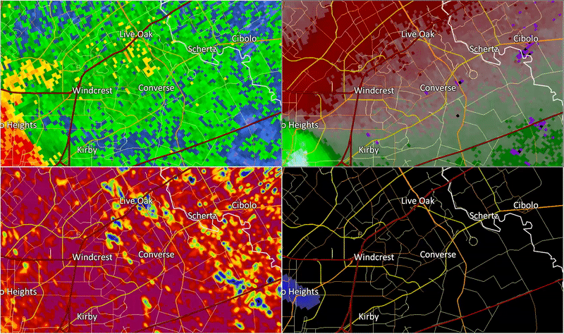
| Northern Hills Tornado (Bexar County) |
| # |
Rating |
Max Winds |
Time (LST) |
Start |
End |
Length |
Width |
Fatalities |
Injuries |
| 2 |
EF1 |
105 MPH |
2243-2249 |
29.5551/-98.4117 |
29.5860/-98.3780 |
3.0 mi |
200 yds |
0 |
? |
A tornado formed just northeast of Thousand Oaks Drive along Scarsdale Drive. The tornado moved
to the northeast through residential neighborhoods between Nacogdoches Road and Stahl Road. The
tornado produced widespread EF0 damage and pockets of EF1 damage to homes and trees. Some single
family homes lost sections of their roofs. There was also significant damage to large utility
structures. The tornado lifted near the intersection of Judson Road and Stahl Road.

(Official Public Information Statement) (Click to Return to Main Page)
| Glen Heights Tornado (Bexar County) |
| # |
Rating |
Max Winds |
Time (LST) |
Start |
End |
Length |
Width |
Fatalities |
Injuries |
| 3 |
EF0 |
80 MPH |
2242-2245 |
29.5016/-98.3601 |
29.5219/-98.3469 |
1.6 mi |
100 yds |
0 |
? |
A tornado formed near the intersection of Walzem Road and New World Drive. This tornado produced
EF0 damage as it traveled to the northeast before lifting near the intersection of Crestway Road
and Oconnor Road. There was primarily damage to trees and minor damage to roofs and carports.

(Official Public Information Statement) (Click to Return to Main Page)
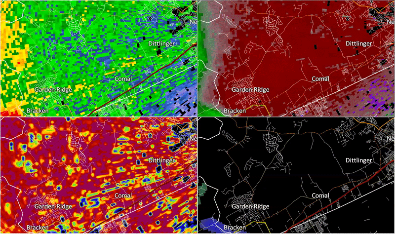
| Schoenthal Ranch Tornado (Comal County) |
| # |
Rating |
Max Winds |
Time (LST) |
Start |
End |
Length |
Width |
Fatalities |
Injuries |
| 4 |
EF0 |
85 MPH |
2300-2302 |
29.6714/-98.2650 |
29.6786/-98.2581 |
0.7 mi |
100 yds |
0 |
? |
A tornado initially occurred at the end of Dedeke Drive near the Dry Comal Creek. This tornado
primarily produced minor tree damage as it traveled northeast before lifting northeast of Tonne
Drive East.

(Official Public Information Statement) (Click to Return to Main Page)
| Seguin Tornado (Guadalupe County) |
| # |
Rating |
Max Winds |
Time |
Start |
End |
Length |
Width |
Fatalities |
Injuries |
| 5 |
EF0 |
85 MPH |
2316-2318 |
29.4605/-97.9487 |
29.4626/-97.9458 |
0.23 mi |
75 yds |
0 |
0 |
This short-lived tornado occurred about 7 miles south of Seguin along Highway 123. This tornado
caused several recreational vehicles to overturn, and caused damage to several sheds and
outbuildings.

(Official Public Information Statement) (Click to Return to Main Page)
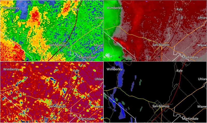
| San Marcos/Kyle Tornado (Hays County) |
| # |
Rating |
Max Winds |
Time |
Start |
End |
Length |
Width |
Fatalities |
Injuries |
| 6 |
EF1 |
100 MPH |
2326-2335 |
29.9156/-98.0480 |
29.9636/-97.8986 |
9.75 mi |
300 yds |
0 |
0 |
The survey team concluded that a tornado began at the intersection of Ranch Road 12 and Hugo
Road where some trees were noted as snapped and a small business had considerable structural
damage. The tornado traveled northeast and likely traversed a large area of land that was
inaccessible until reaching Hilliard Road and a neighborhood along Thousand Oaks Loop where a
wide area of considerable tree damage, including a tree uprooted and fallen onto a vehicle, was
found. The tornado path crossed the Blanco River before ending near the Kyle Cemetery on Old
Stagecoach Road. At this point, damage became much less significant and sporadic moving east
toward I-35.

(Official Public Information Statement) (Click to Return to Main Page)
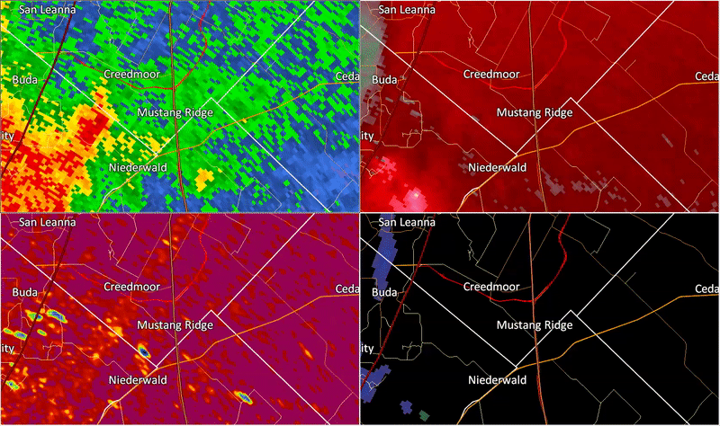
| Niederwald/Mustang Ridge Tornado (Hays/Travis County) |
| # |
Rating |
Max Winds |
Time |
Start |
End |
Length |
Width |
Fatalities |
Injuries |
| 7 |
EF0 |
85 MPH |
2348-2351 |
30.0361/-97.7415 |
30.0613/-97.7046 |
3.0 mi |
100 yds |
0 |
0 |
The survey team concluded that many damage areas across central Hays county were due to straight
line winds, but a new tornado indeed developed northwest of Niederwald. Damage in this area
included a destroyed aluminum barn structure, car port damage, and a few trees with large limbs
snapped. As the tornado moved northeast into the Mustang Ridge area, multiple mobile homes had
significant roof damage consistent with EF-0 speeds. The tornado likely lifted as it approached
SH 130 as damage east of SH 130 was found to be caused by straight line winds.

(Official Public Information Statement) (Click to Return to Main Page)
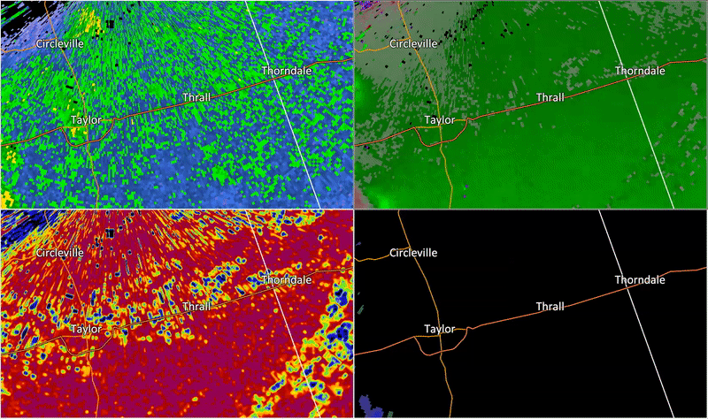
| Thrall/Noack Tornadoes (Williamson County) |
| # |
Rating |
Max Winds |
Time |
Start |
End |
Length |
Width |
Fatalities |
Injuries |
| 8 |
EF2 |
118 MPH |
0025-0033 |
30.5501/-97.3594 |
30.6312/-97.2436 |
9.4 mi |
200 yds |
0 |
0 |
| 9 |
EF2 |
112 MPH |
0028-0031 |
30.5443/-97.3525 |
30.5709/-97.2883 |
4.24 mi |
100 yds |
0 |
0 |
[1] Thrall (EF2)
This tornado was the northern one of a pair on near parallel tracks a few miles south of U.S.
Highway 79. Damage was sporadic...but concentrated when it occurred. The most significant damage
was to a metal building system home...at least five other single family homes...and 12 railroad
cars blown off the tracks east of Thrall. The train cars may have also been affected by strong
straight-line winds.
[2] Noack (EF2)
This tornado was the southern one of a pair on near parallel tracks a few miles south of U.S.
Highway 79. Damage was sporadic...but concentrated when it occurred. The most significant damage
was to a 3-bin grain storage facility...where the bins were completely destroyed and swept from
their foundations. Additional damage occurred to an extension of Christ Lutheran Church of Noack
on FM 112...where the walls were bolted to the foundation.

(Official Public Information Statement) (Click to Return to Main Page)


 Follow us on YouTube