October 14, 2014 Atlanta and Central Georgia Tornadoes
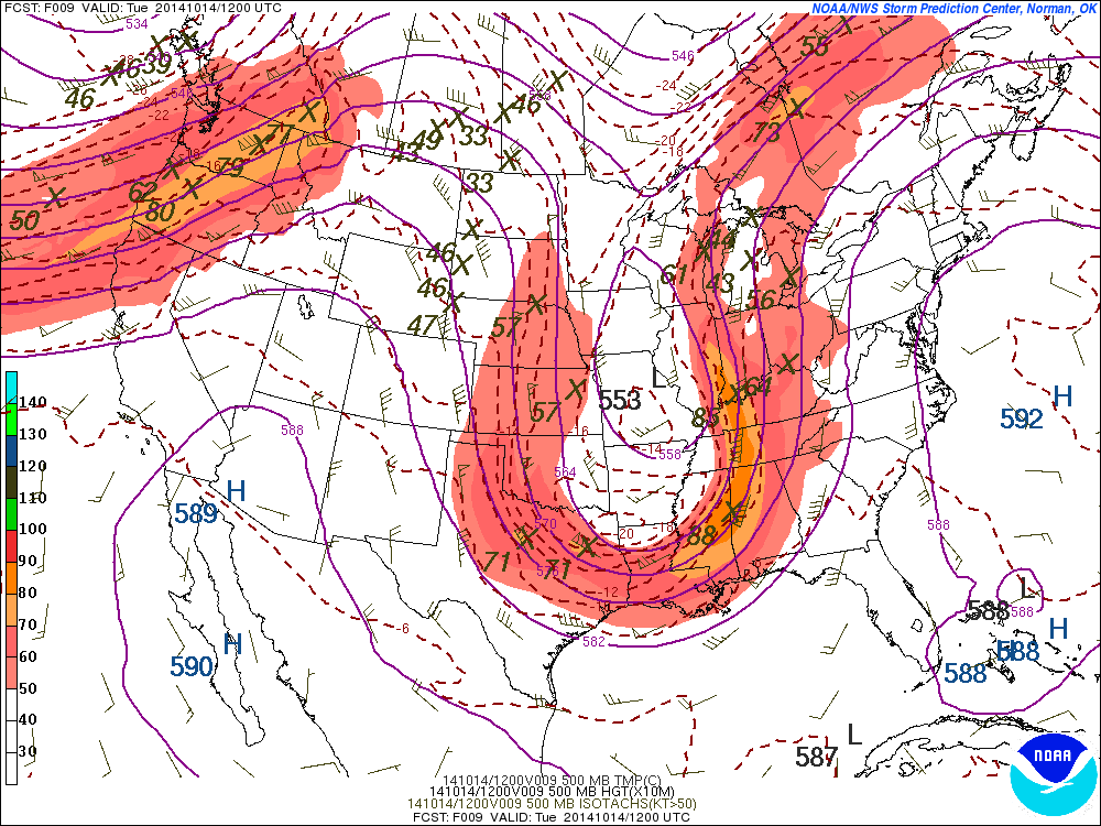
A potent storm system brought a line of severe storms that quickly spawned 6 short-lived tornadoes across portions of north and central Georgia during the early morning hours of October 14, 2014. Of the 6 tornadoes, 5 tracked across the Atlanta area between 5:00am and 6:00am. These tornadoes formed along the northern bowing edge of the line of storms, which was aided by a strong low level jet of wind. The overall event was ahead of a strong frontal boundary rotating around a deep low pressure system characterized by strong wind shear (change of wind speed or direction above the surface) and low instability (energy for upward motion with storms), placing the area under the main threats of strong damaging winds and tornadoes. Not only was the time of day particularly dangerous as the tornadoes formed before sunrise, but they were likely rain-wrapped or additionally hidden from view from all of the showers given the abundant moisture ahead of the front. Fortunately there were no injuries, however there were many downed or snapped trees along with structural damage. The greatest damage occurred in the Alpharetta area where an EF-1 tornado was surveyed with winds up to 105 mph.
|
|
 |
| 500-mb pattern on October 14, 2014 | Local Storm Reports from October 14, 2014 |
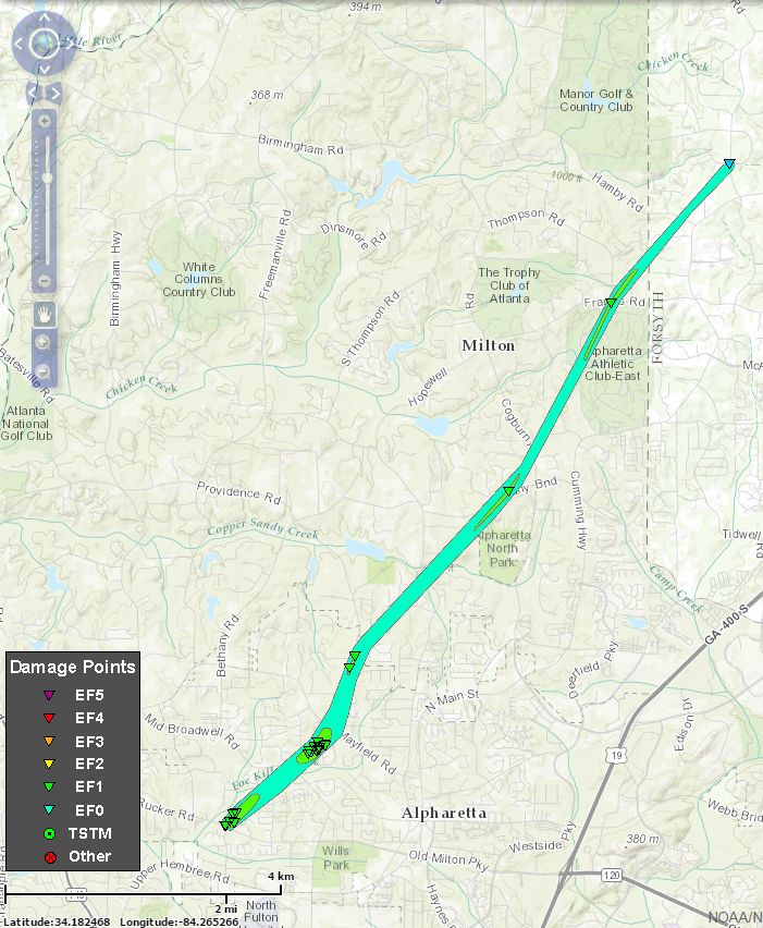
Alpharetta/Milton Tornado:
AN EF1 TORNADO WITH MAXIMUM WINDS OF 105 MPH TOUCHED DOWN 2 MILES WEST OF ALPHARETTA AND TRAVELED 7.5 MILES THROUGH MILTON BEFORE LIFTING IN FORSYTH COUNTY. HUNDREDS OF TREES ALONG THIS PATH THAT WERE SNAPPED OR UPROOTED. DAMAGE TO HOMES WAS DUE TO THESE TREES FALLING ON THEM WITH SOME MODERATE ROOF DAMAGE THE RESULT. THE MAX PATH WIDTH WAS 100 YARDS ALTHOUGH THERE WAS CONSIDERABLE DAMAGE OUTSIDE THIS PATH DUE TO THE STRAIGHTLINE WINDS WITHIN THE SQUALL LINE.
|
|
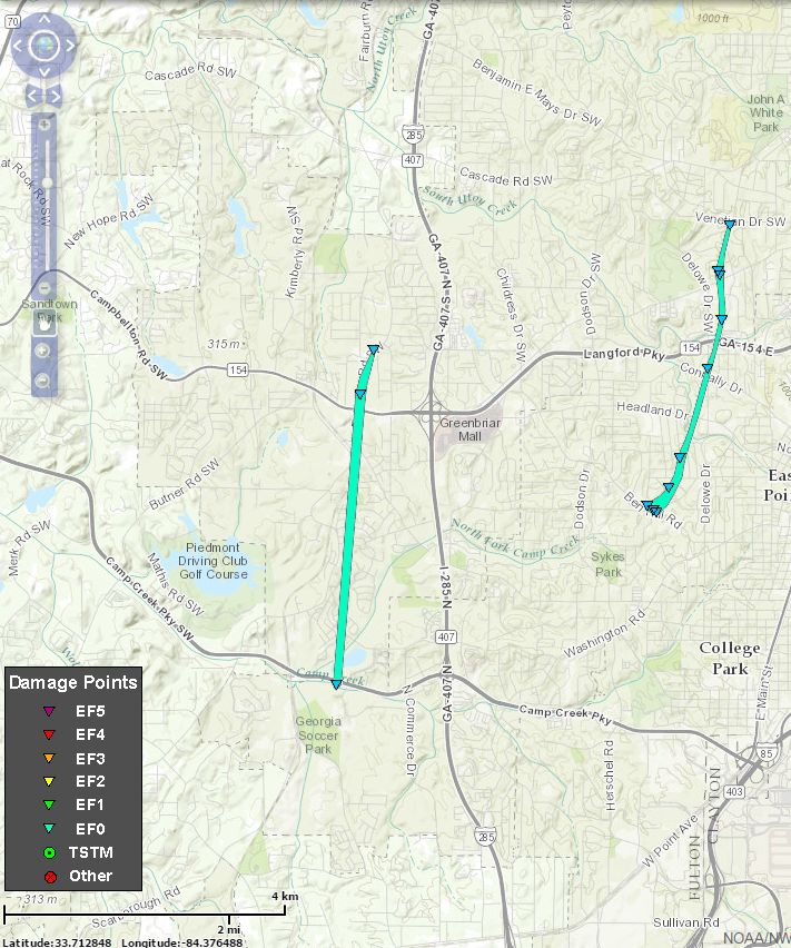
EastCobb/Fulton Tornado:
AN EF1 TORNADO WITH MAXIMUM WINDS OF 95 MPH TOUCHED DOWN 8 MILES NW OF SANDY SPRINGS AND TRAVELED 1.25 MILES AFFECTING PORTIONS OF COBB AND FULTON COUNTIES. HUNDREDS OF TREES WERE SNAPPED OR UPROOTED ALONG THE PATH. DAMAGE TO HOMES DUE TO THESE TREES CAUSING MODERATE DAMAGE OF ROOFS. THE MAX PATH WIDTH WAS 100 YARDS ALTHOUGH THERE WAS CONSIDERABLE DAMAGE OUTSIDE THIS PATH DUE TO STRAIGHTLINE WINDS WITHIN THE SQUALL LINE.
|
|
Vinings Tornado:
AN NWS SURVEY TEAM DETERMINED AN EF0 TORNADO WITH MAXIMUM WINDS OF 75 MPH TOUCHED DOWN 2 MILES SSE OF THE VININGS AND TRAVELED 1 MILE BEFORE LIFTING 1 MILE SSE OF THE VININGS. DOZENS OF TREES ALONG THE PATH WERE SNAPPED OR UPROOTED. THE MAX PATH WIDTH WAS 75 YARDS.
|
|
East Point Tornado:
AN NWS SURVEY TEAM DETERMINED AN EF0 TORNADO WITH MAXIMUM WINDS OF 80 MPH TOUCHED DOWN 1 MILE WEST OF EAST POINT AN TRAVELED 3 MILES BEFORE LIFTING 2.5 MILES NNW OF EAST POINT. DOZENS OF TREES WERE SNAPPED OR UPROOTED ALONG THE PATH ALONG WITH MINOR ROOF DAMAGE TO SOME HOMES DUE TO TREES FALLING ON THEM. THE MAX PATH WIDTH WAS 75 YARDS.
|
|
Camp Creek Tornado:
AN EF0 TORNADO WITH MAXIMUM WINDS OF 75 MPH TOUCHED DOWN 5 MILES WEST OF COLLEGE PARK AND TRAVELED 2.5 MILES BEFORE LIFTING 4 MILES WNW OF EAST POINT. DOZENS OF TREES ALONG THE PATH WERE SNAPPED OR UPROOTED WITH MINOR ROOF DAMAGE TO SOME HOMES DUE TO TREES FALLING ON THEM. THE MAX PATH WIDTH WAS 75 YARDS.
|
|
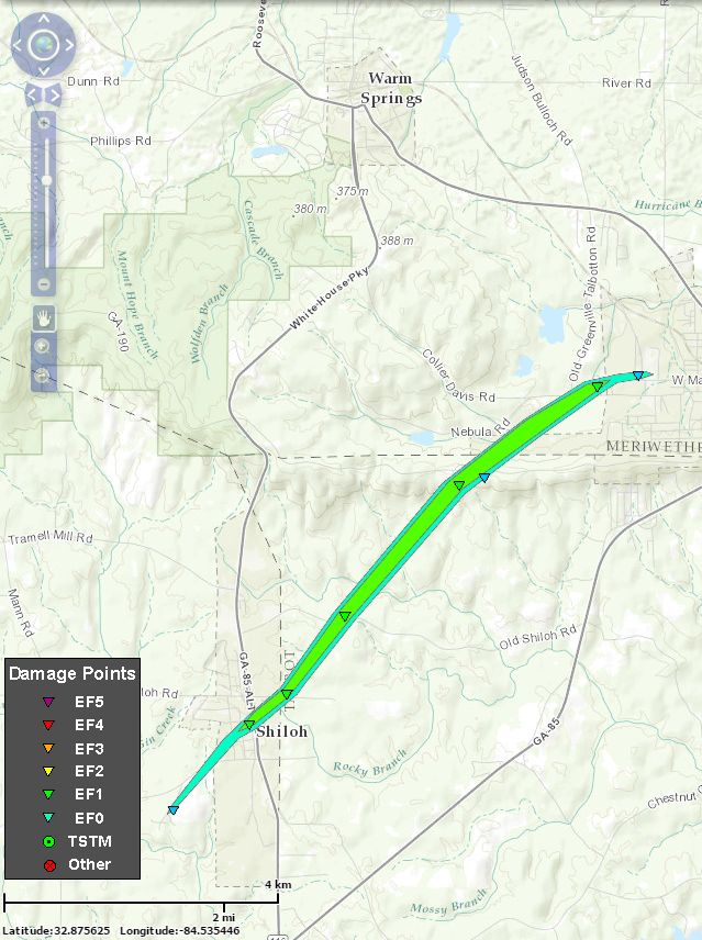
Harris County Tornado:
AN EF1 TORNADO WITH MAXIMUM WINDS OF 100 MPH TOUCHED DOWN 1 MILE SOUTHWEST OF SHILOH AND TRAVELED NORTHEAST 5.9 MILES INTO NORTHWEST TALBOT AND SOUTHERN MERIWETHER COUNTIES. A HOME ON SKYLINE DR HAD ITS ROOF BLOWN OFF AND A LARGE SHED DESTROYED. A FEW OTHER HOMES HAD MINOR DAMAGE. APPROX 100 TREES WERE SNAPPED OR UPROOTED. MAX PATH WIDTH 200 YARDS.
|
|


 Follow us on YouTube