May 24, 2017 Tornado Event:
[Overview]
Tornadoes of May 24, 2017:
(in chronological order by county)
 |

|
|
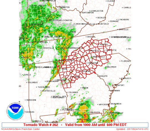
A Tornado Watch was initially issued across north Georgia during the morning hours.
|
A second Tornado Watch was issued by late morning across central and south Georgia. |
|

|
| Several areas across north and central Georgia received severe thunderstorm damage on May 24th. |
Tornadoes:
1) Whitfield County Tornado:
A brief tornado touched down northeast of Dalton along Highway 71 (Cleveland Highway), snapping and uprooting several trees between 3rd Street and West Hill View Drive. The tornado continued northeast and created the most significant damage along the south end of Lynn Drive where numerous large trees were snapped or uprooted in an approximate 200 yard wide path. In this location, a couple of trees were snapped near the base which resulted in the rating of a low-end EF-1 with estimated maximum winds around 90 mph. A camper was also rolled about 20 yards away from its original location near Lynn Drive. Several more trees were found snapped near Creekwood Lane Northeast just before the tornado lifted.
 |
| Damage Path - Whitfield County |
|
| County |
Rating |
# of Injuries |
KML |
| Whitfield |
EF-1 |
0 |
 |
|
| Rating: |
EF-1 |
| Peak Wind: |
90 MPH |
| Path Length: |
1.6 miles |
| Path Width: |
200 yards |
| Fatalities: |
0 |
| Injuries: |
0 |
| Start Date: |
May 24, 2017 |
| Start Time: |
9:45 AM EDT |
| Start Lat/Lon: |
34.8186 / -84.9512 |
| End Date: |
May 24, 2017 |
| End Time: |
9:49 AM EDT |
| End Lat/Lon: |
34.8299 / -84.9263 |
|
|
|

|
 |
| A number of trees were uprooted on this property by the tornado. |
Several trees were snapped and uprooted near this home. |
2) Gordon County Tornado #1:
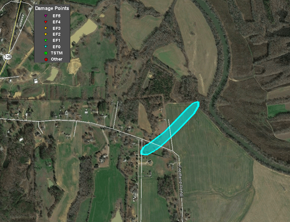
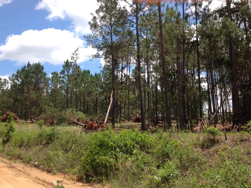
A brief tornado touched down 1 mile east of Resaca between Swan Drive Northeast and Fite Bend Road Northeast where several large trees were snapped and uprooted in an approximately 70 yard wide path. The tornado then tracked across a hay field and into a small wooded area where it snapped a few large tree branches before lifting.
 |
| Damage Path - Gordon County |
|
| County |
Rating |
# of Injuries |
KML |
| Gordon |
EF-0 |
0 |
|
|
| Rating: |
EF-0 |
| Peak Wind: |
75 MPH |
| Path Length: |
0.3 miles |
| Path Width: |
70 yards |
| Fatalities: |
0 |
| Injuries: |
0 |
| Start Date: |
May 24, 2017 |
| Start Time: |
10:47 AM EDT |
| Start Lat/Lon: |
34.5849 / -84.9212 |
| End Date: |
May 24, 2017 |
| End Time: |
10:48 AM EDT |
| End Lat/Lon: |
34.5871 / -84.9212 |
|
|
|
|
 |
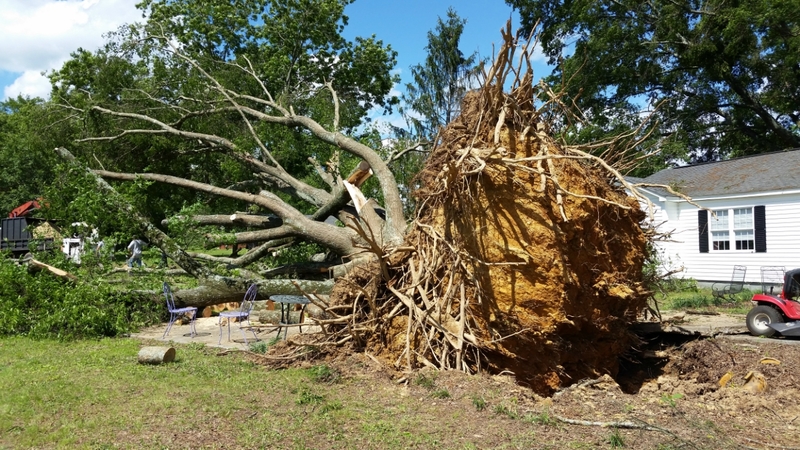
| This large tree was uprooted. |
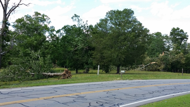
Trees were damaged and uprooted on this property. |
3) Gordon County Tornado #2:
The same storm that produced a brief tornado 1 mile east of Resaca produced another brief tornado about 3.4 miles ENE of Resaca along Nicklesville Road. Damage to the roof of a home and small barn was found along with several large trees snapped and uprooted along an approximate 90 yard wide path. Based on visual damage, the tornado was on the ground for approximately 0.3 miles before lifting.
 |
| Damage Path - Gordon County |
|
| County |
Rating |
# of Injuries |
KML |
| Gordon |
EF-0 |
0 |
|
|
| Rating: |
EF-0 |
| Peak Wind: |
75 MPH |
| Path Length: |
0.3 miles |
| Path Width: |
90 yards |
| Fatalities: |
0 |
| Injuries: |
0 |
| Start Date: |
May 24, 2017 |
| Start Time: |
10:50 AM EDT |
| Start Lat/Lon: |
34.5984 / -84.8875 |
| End Date: |
May 24, 2017 |
| End Time: |
10:51 AM EDT |
| End Lat/Lon: |
34.6017 / -84.8849 |
|
|
|

|
 |
| This barn received roof damage in the tornado. |
Several trees were uprooted off Nicklesville Road. |
4) Gilmer County Tornado:
A very brief tornado touched down in a largely wooded area about 7.4 miles WNW of Ellijay along Rogers Creek Road. Several large trees were found snapped and uprooted along a small path. This damage was consistent with a circulation seen from radar that had a history of producing brief tornadoes.
 |
| Damage Path - Gilmer County |
|
| County |
Rating |
# of Injuries |
KML |
| Gilmer |
EF-0 |
0 |
|
|
| Rating: |
EF-0 |
| Peak Wind: |
70 MPH |
| Path Length: |
0.1 miles |
| Path Width: |
30 yards |
| Fatalities: |
0 |
| Injuries: |
0 |
| Start Date: |
May 24, 2017 |
| Start Time: |
11:16 AM EDT |
| Start Lat/Lon: |
34.7295 / -84.6111 |
| End Date: |
May 24, 2017 |
| End Time: |
11:17 AM EDT |
| End Lat/Lon: |
34.7302 / -84.6099 |
|
|
|

|
 |
| A few trees were uprooted at this location along Rogers Creek Road. |
Here is another view of some uprooted trees along Rogers Creek Road. |
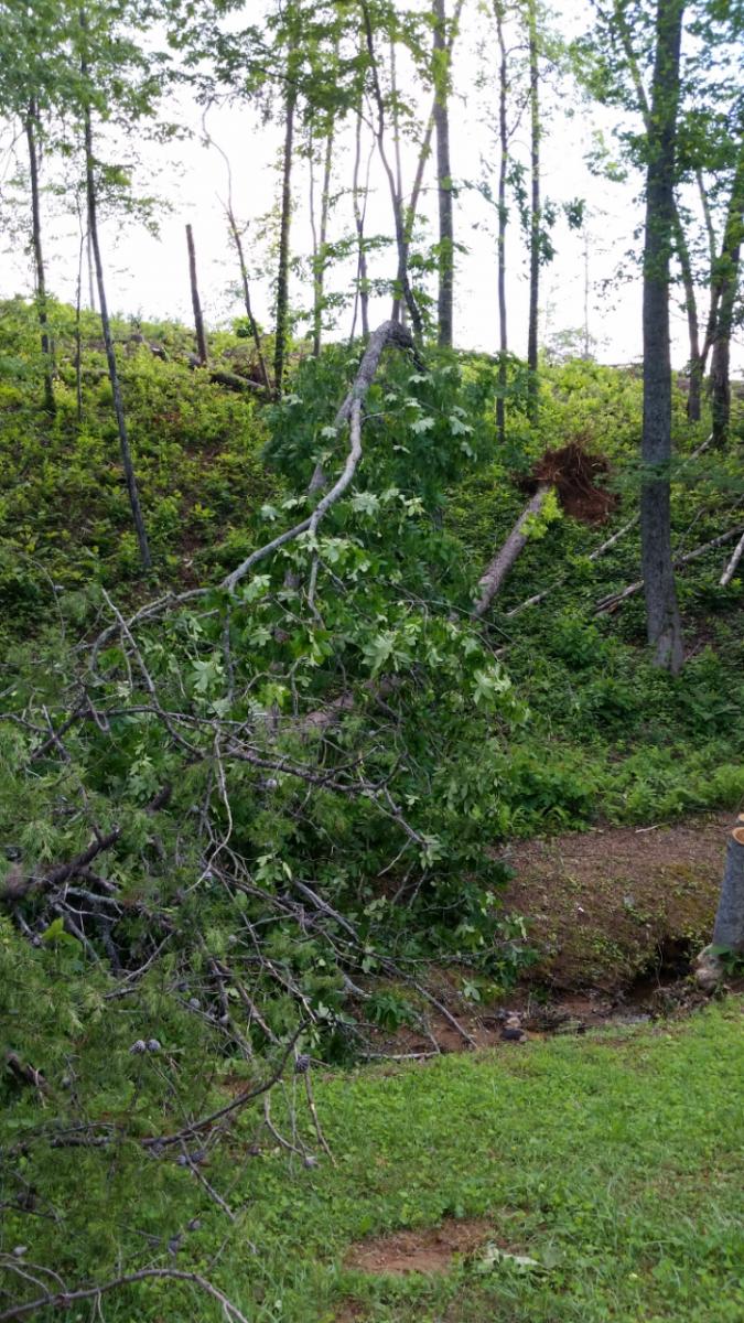
5) Fannin County Tornado:
A very brief tornado touched down 2.3 miles NE of downtown Blue Ridge where several large trees were snapped and uprooted just east of Highway 515 (US 76) along McKinney Road. Similar to the brief Gilmer County tornado, this damage was consistent with a circulation seen from radar that had a history of producing brief tornadoes.
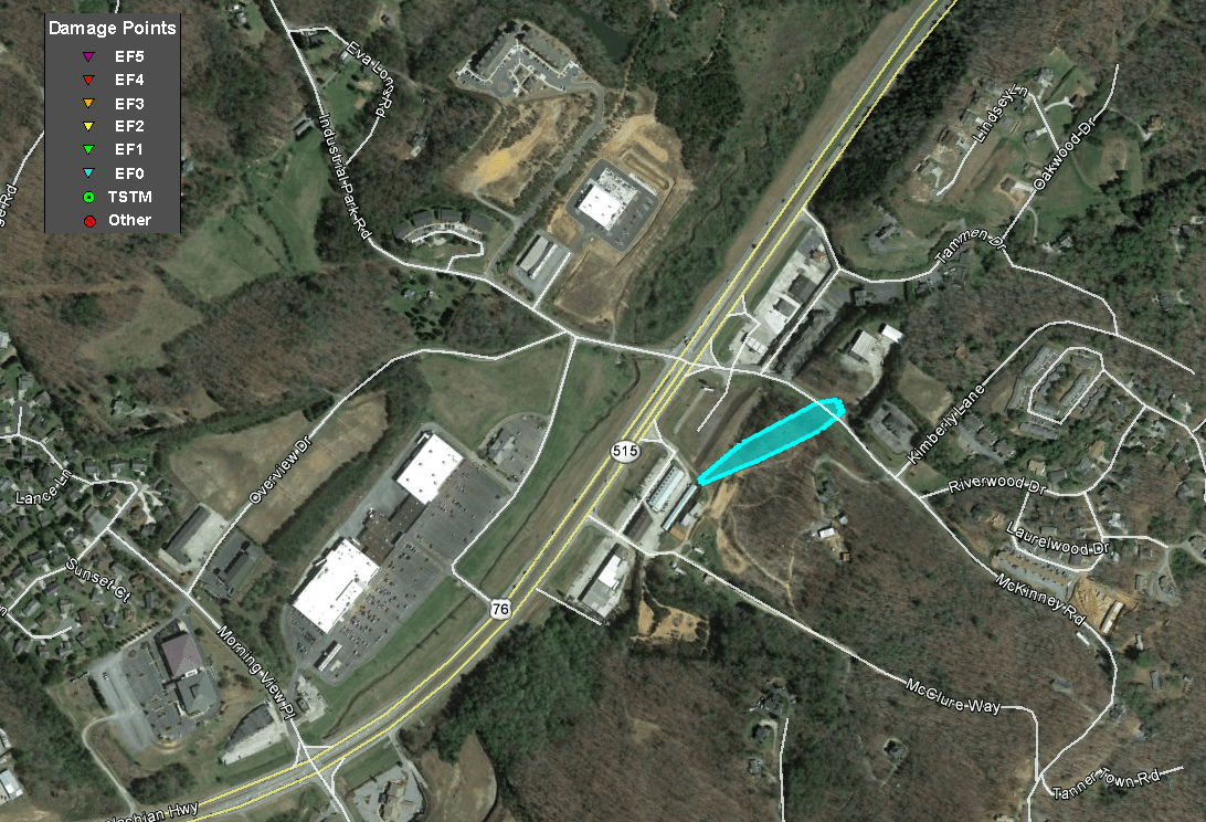 |
| Damage Path - Fannin County |
|
| County |
Rating |
# of Injuries |
KML |
| Fannin |
EF-0 |
0 |
|
|
| Rating: |
EF-0 |
| Peak Wind: |
75 MPH |
| Path Length: |
0.1 miles (~240 yards) |
| Path Width: |
35 yards |
| Fatalities: |
0 |
| Injuries: |
0 |
| Start Date: |
May 24, 2017 |
| Start Time: |
11:43 AM EDT |
| Start Lat/Lon: |
34.8801 / -84.2944 |
| End Date: |
May 24, 2017 |
| End Time: |
11:44 AM EDT |
| End Lat/Lon: |
34.8812 / -84.2924 |
|
|
|
|
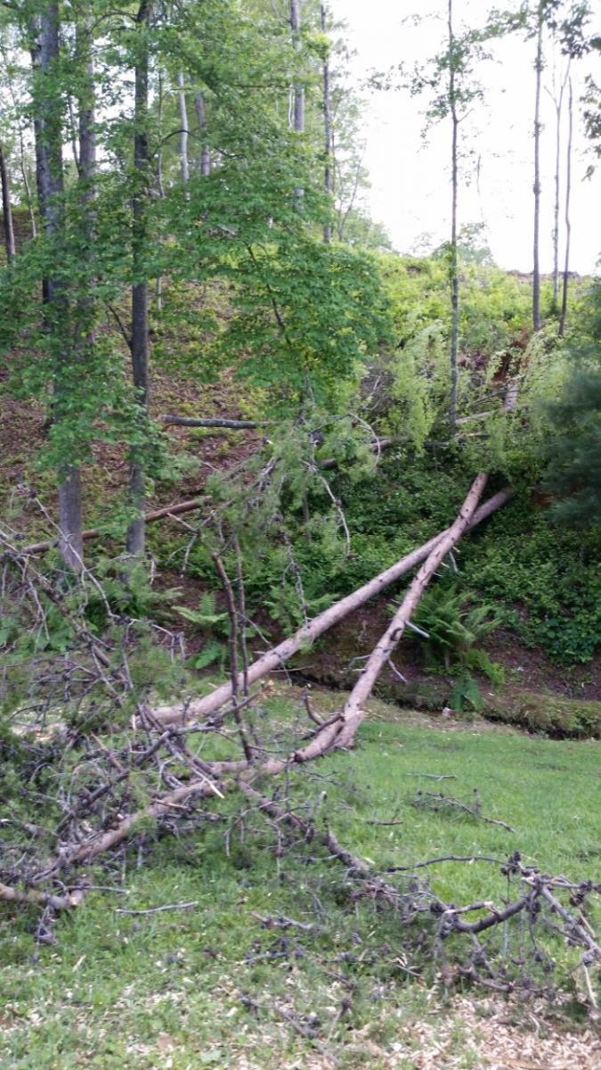 |
| Several trees were downed at this location along McKinney Road. |
Several trees were downed at this location along McKinney Road. |
6) Laurens County Tornado:
An EF-0 tornado initially touched down just off Valambrosia Road where it downed a few trees. The tornado next crossed Clover Leaf Lane where it blew some metal trim off of a mobile home and collapsed a small metal carport. This debris was strewn in the wooded area behind the mobile home. Severeal pine trees were also uprooted at this location. As the tornado crossed Irish Lane, a number of hardwood and softwood trees were uprooted. The tornado continued northeastward, downing between 20 and 40 trees on a railroad track near Moore Station Road. Through the remainder of the tornado's path, trees were intermittently snapped or uprooted. The final damage location before the tornado lifted was near Fairview Park Hospital where the tops were blown out of a couple of pine trees.
 |
| Damage Path - Laurens County |
|
| County |
Rating |
# of Injuries |
KML |
| Laurens |
EF-0 |
0 |
|
|
| Rating: |
EF-0 |
| Peak Wind: |
80 MPH |
| Path Length: |
2.2 miles |
| Path Width: |
240 yards |
| Fatalities: |
0 |
| Injuries: |
0 |
| Start Date: |
May 24, 2017 |
| Start Time: |
2:05 PM EDT |
| Start Lat/Lon: |
32.5133 / -82.9802 |
| End Date: |
May 24, 2017 |
| End Time: |
2:10 PM EDT |
| End Lat/Lon: |
32.5329 / -82.9489 |
|
|
|

|
 |
| This mobile home had metal trim removed by the tornado. A nearby metal carport was also destroyed. |
Several pine trees were uprooted by the tornado at this location. |
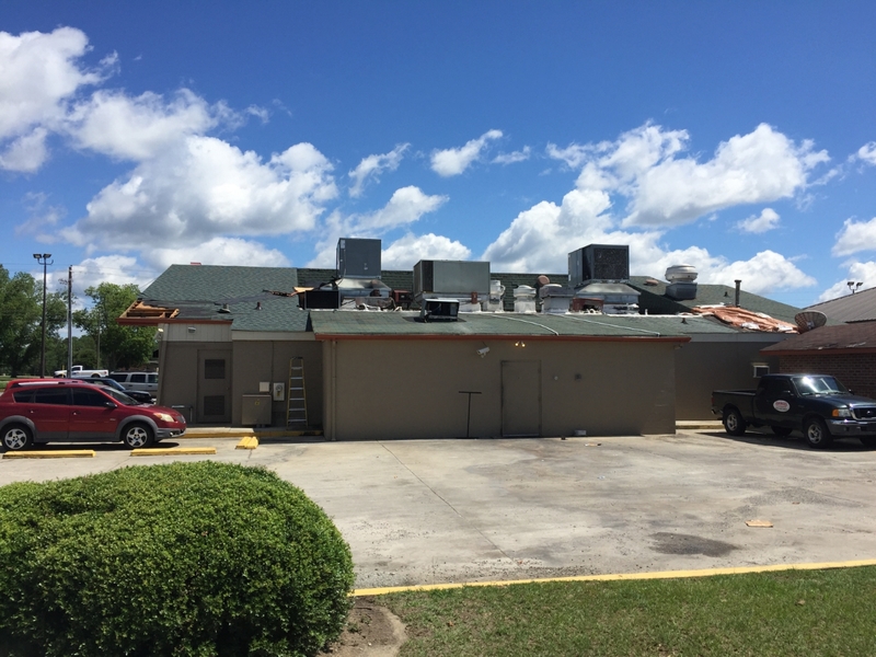
7) Toombs County Tornado:
A low-end EF-1 tornado first touched down in a southeast residential portion of Vidalia and tracked east-northeastward across Highway 280 where it did some minor structural damage. This damage included roof damage to several businesses in an area generally across from Meadows Regional Medical Center including a Shoney's as well as bending a large flag pole near Brantley's Marine and Guns. Other damage along the path included numerous hardwood and softwood trees either snapped or uprooted. The tornado lifted just north of the city of Lyons along Highway 1.
 |
| Damage Path - Toombs County |
|
| County |
Rating |
# of Injuries |
KML |
| Toombs |
EF-1 |
0 |
|
|
| Rating: |
EF-1 |
| Peak Wind: |
95 MPH |
| Path Length: |
4.3 miles |
| Path Width: |
440 yards (0.25 miles) |
| Fatalities: |
0 |
| Injuries: |
0 |
| Start Date: |
May 24, 2017 |
| Start Time: |
11:09 PM EDT |
| Start Lat/Lon: |
32.2002 / -82.3925 |
| End Date: |
May 24, 2017 |
| End Time: |
11:16 PM EDT |
| End Lat/Lon: |
32.2214 / -82.3251 |
|
|
|
|
 |
| This Shoney's restaurant in Vidalia received roof damage from the tornado. |
A number of trees were uprooted at this location along Cecil Anderson Road. |


 Follow us on YouTube