March 3, 2019 Tornadoes:
[Overview]
This report lists the 14 recorded tornadoes in order of tornadic intensity.
| EF-3 | EF-2 |
|
Muscogee/Harris/Talbot Counties (140 mph) |
(125 mph) |
|
(115 mph) |
|
| EF-1 | EF-0 |
|
(105 mph) |
(85 mph) |
|
(105 mph) |
(85 mph) |
|
(100 mph) |
(80 mph) |
|
(95 mph) |
(80 mph) |
|
(90 mph) |
(70 mph) |
|
(90 mph)
|
|
|
 |
|
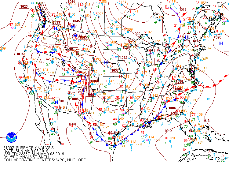
| Surface map (4 pm - March 3) |
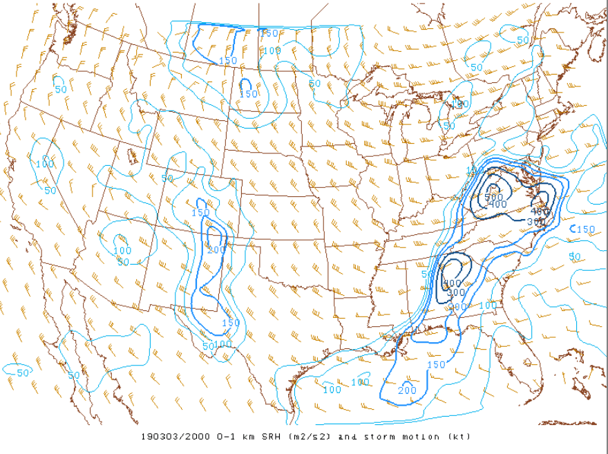
0-1 km storm relative helicity (SRH) map (3 PM - March 3) |
|
|
 |
|
|
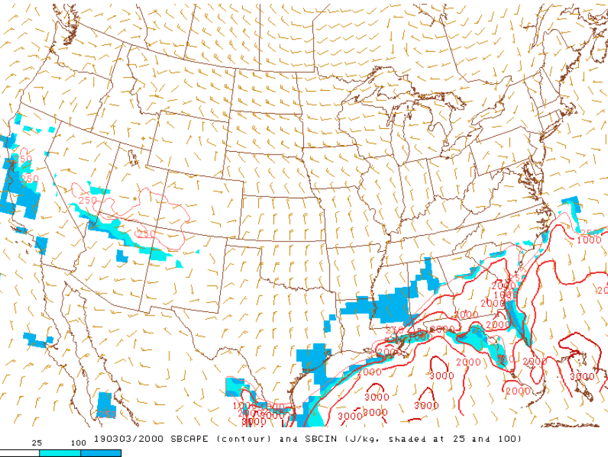
Surface Based CAPE (3 pm - March 3) SBCAPE reached over 1000 J/kg for much of central GA. |
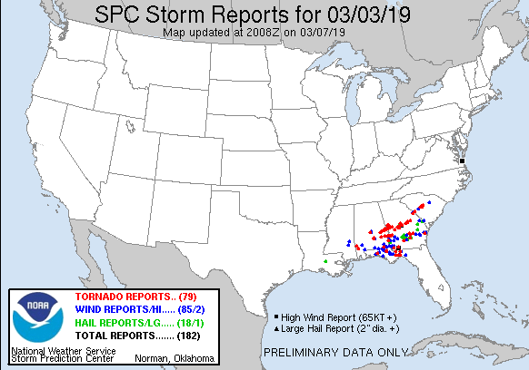
March 3 Storm Reports Numerous tornadoes occurred across the Southeast. |
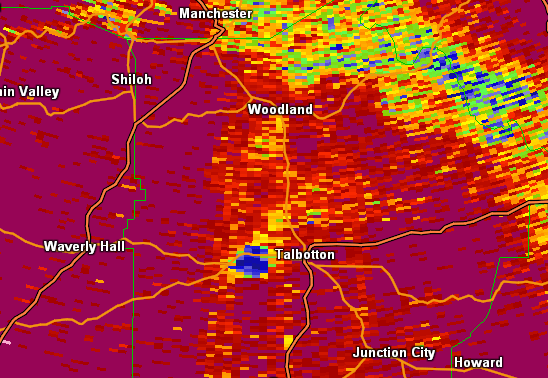
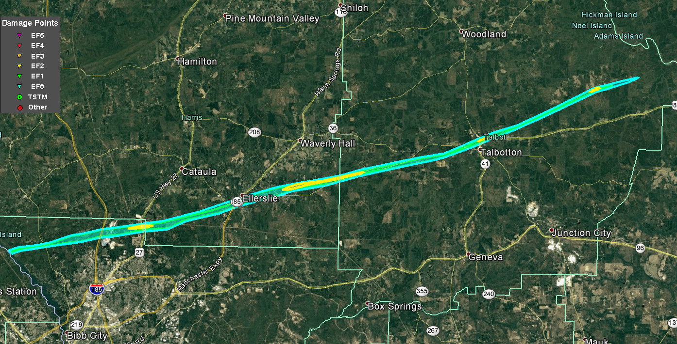
29 minutes after tornadogenesis, and after a deadly and destructive path through Macon County and Lee County in Alabama, the tornado crossed the Chattahoochee River into Georgia at 3:29 PM EST near Winding Ridge Rd in Muscogee County. The tornado continued ENE along Winding Ridge Rd, Old River Rd, and Biggers Rd causing extensive damage to forested areas. Large swaths of softwood trees were uprooted or snapped near the base of the ground. Upon crossing Whitesville Rd in NW Muscogee County, EF-1 damage was recorded over a 750 yard path perpendicular to the tornado's path. The tornado then continued and crossed the I-185 interstate around 3:37 PM EST just 1.5 miles SW of Fortson.
At 3:39 PM EST, the tornado crossed U.S. Hwy 27, also known as Veterans Parkway, between Woodridge Rd and Almond Rd, and toppled and mangled a large cellular tower along with a swath of pine trees with wind speeds of approximately 140 mph. Confidence in this EF-3 wind speed was increased when nearly a dozen metal guidewires attached to the tower measuring over one inch in diameter were snapped.
The tornado then immediately crossed into Harris County, and continued to cause mostly EF-1 damage along Gray Rock Rd and the winding Rip Smith Rd snapping hundreds of trees along the way. The tornado then reached the south side of Ellerslie around 3:47 PM EST, continuing to parallel Highway 315 where hundreds of softwood and several hardwood trees were snapped. Minor roof damage was noted to several homes with shingles pulled off, as well as one home with damage to the attic and top floor. Further east and just north of highway 315, along Mount Airy Road, just north of Apachee trail there were hundreds of softwood trees down, as well as a home with significant damage to the top floor. Across the street, were several homes with missing shingles and a carport that was destroyed. Damage in this area was consistent with EF2 120 mph winds.
The tornado then continued ENE to Ridgeway Rd, just north of Hwy 315, where EF2 damage continued to be recorded with several dozen softwood trees snapped near their bases. As Hwy 315 then began to turn northeastward the tornado began to run alongside the highway and eventually intercepted it. Along this route, dozens of additional trees were found blown north of the highway. At approximately 3:54 PM EST, the tornado crossed into Talbot County, quickly destroying a small church, a mobile trailer home, dozens of trees and causing extensive damage to a two-story home. The Humble Zion Church, which was completely demolished with no walls left standing, was made of heavy-duty cinder blocks and mortar, with several structures within the church blown to surrounding areas resulting in an approximation of wind speeds of 140 mph. The tornado continued ENE crossing a northeastward oriented Hwy 315, and weakened significantly. EF-1 wind damage was found consistently through forested areas in and around Hwy 315, along Callier Rd, O'Neal Rd, and Mitchell Rd.
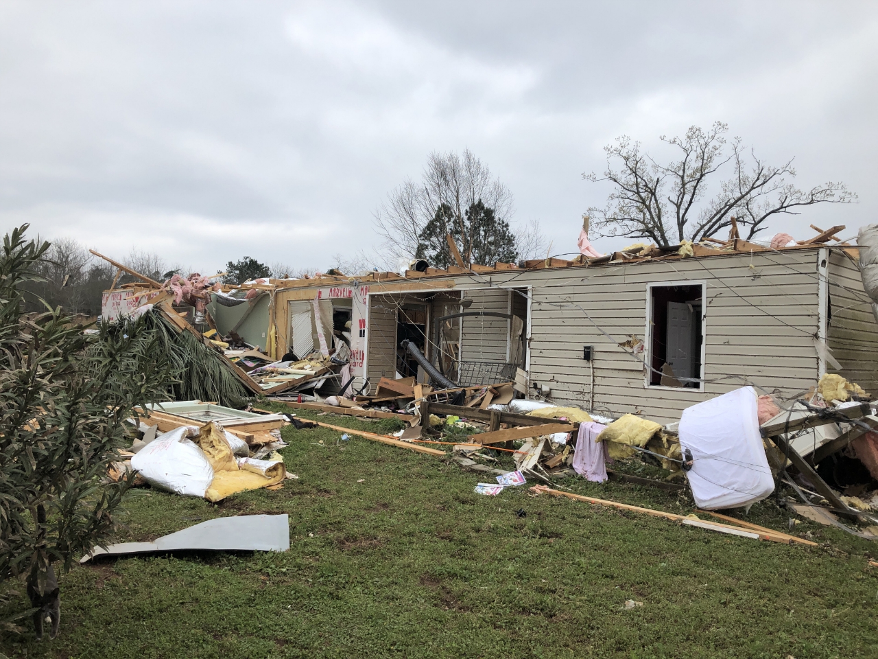
Between 4:03 and 4:06 PM EST, the tornado moved into northern Talbotton, causing extensive damage to trees and completely destroying numerous homes. High End EF-1 damage was observed along Adams Rd, in the Northwest of town as wide swaths of trees were observed to be snapped going into town. The tornado intensified again as it intersected Washington Ave, the main north-south road through town causing mostly high-end EF-2 damage. A few double-wide and single-wide manufactured homes were completely turned over, twisted, and destroyed. It was nearly unrecognizable where these manufactured homes originally sat. Contents of the homes were blown over a quarter mile into the woods behind them. One single family home was twisted at least 10 feet off of it's foundation and another had its second story completely removed. Two brick-and-mortar apartments were completely blown down by approximately 140 mph winds with most of the slabs being laid bare in the tornados wake. At least a dozens of cars were also destroyed, being peppered with rocks and debris, with windows blown out, and several which were blown laterally by several feet and one sedan which had rolled up on top of a small pick-up truck and then fell back to its side. Several other manufactured homes lost their roofing and some lost whole rooms to the winds. Remarkably, no fatalities occurred but seven injuries were reported in town. The tornado then continued ENE along U.S. Hwy 80 as it exited town, continuing to snap and uproot hundreds of trees in its wake. Another manufactured home was found to have been rolled and torn apart, with another having the rear half collapsed from winds and falling trees. The storm continued ENE going between U.S. Hwy 80 and Boot Kelly Rd & Pobiddy Rd. Cross-roads were sparse, but when available showed damage consistent with EF-1 wind speeds. On Poplar Cross Rd, between Pobiddy and U.S. Hwy 80 EF-2 damage was found in a small valley with hundreds of softwood trees snapped near their bases. The last recorded damage point occurred east of the intersection of George Smith Rd and Carl Mathis Rd with a few final trees snapped off.
The tornado then dissipated at approximately 4:16 PM EST about 10.5 miles ENE of Talbotton, Georgia in eastern Talbot county. In total, the tornado tracked 68.8 miles over 76 minutes, with 42.0 miles and 47 minutes of the track on the Georgia side of the border. Remarkably, no fatalities occurred in Georgia but seven injuries were reported in and around Talbotton.
|
|
|
|
 |
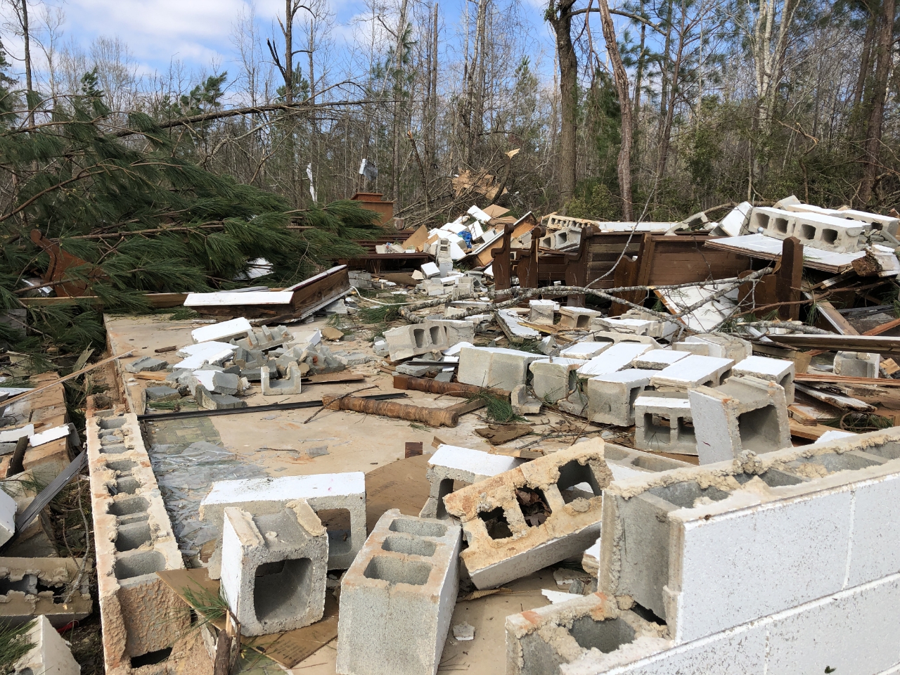
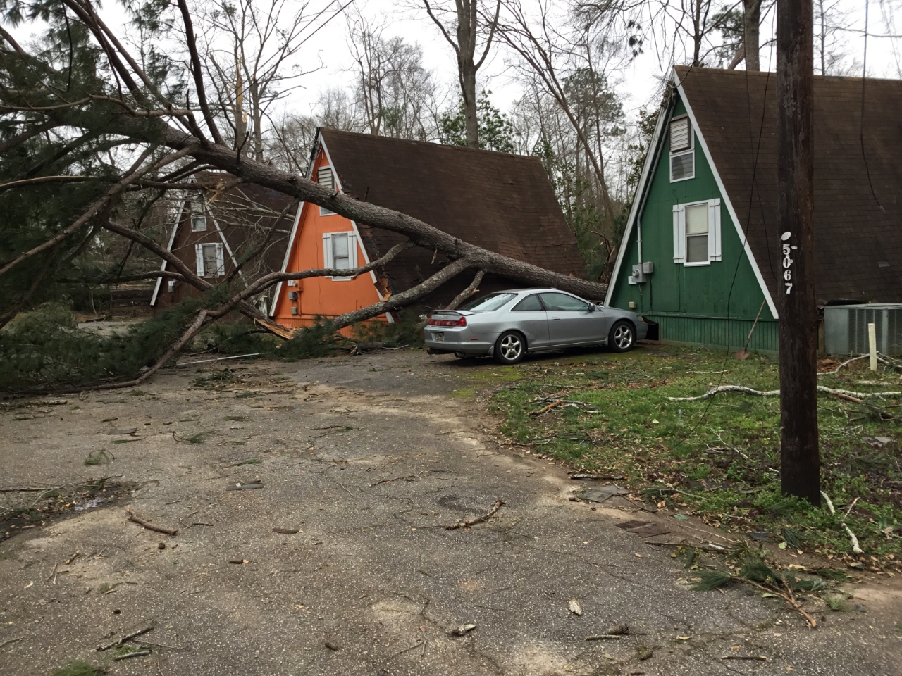
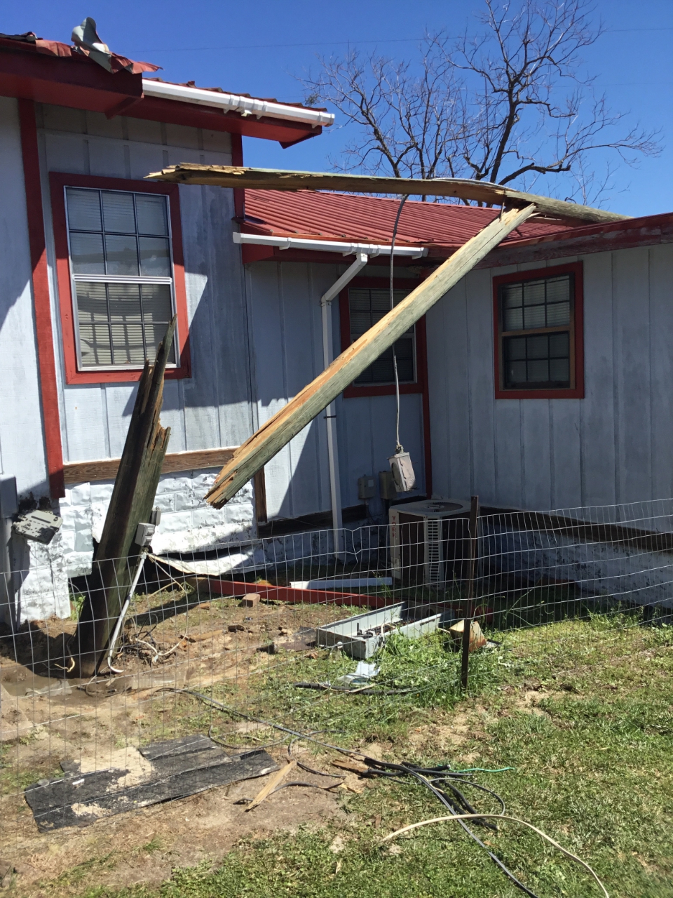
| A house was destroyed in Baughville. | A residence was destroyed in Talbotton. |
|
|
 |
| This cell tower in Muscogee County was blown to the ground by the tornado. | This cinder block church in Talbot County was destroyed by the tornado. |
|
|
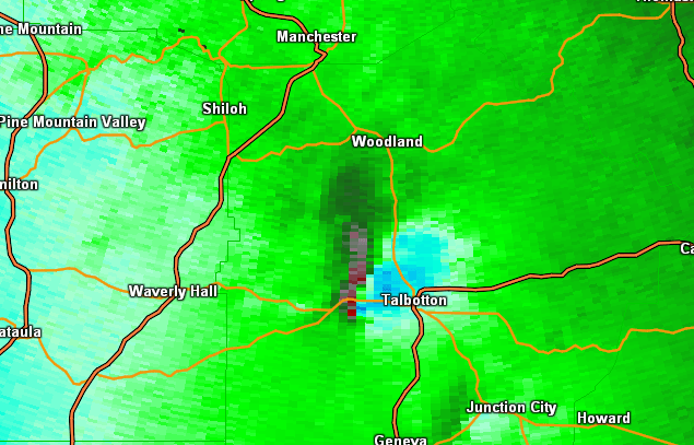 |
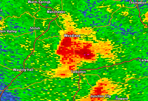
| Reflectivity (4:01 PM EST) | Velocity (4:01 PM EST) |
 |
| Correlation Coefficient showing the presence of lofted debris (4:01 PM EST) |
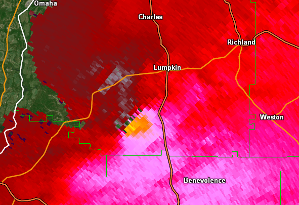
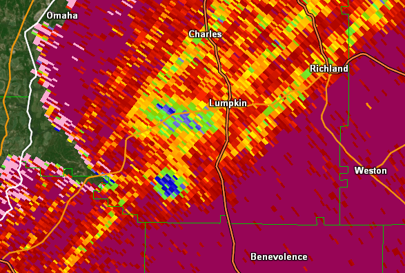
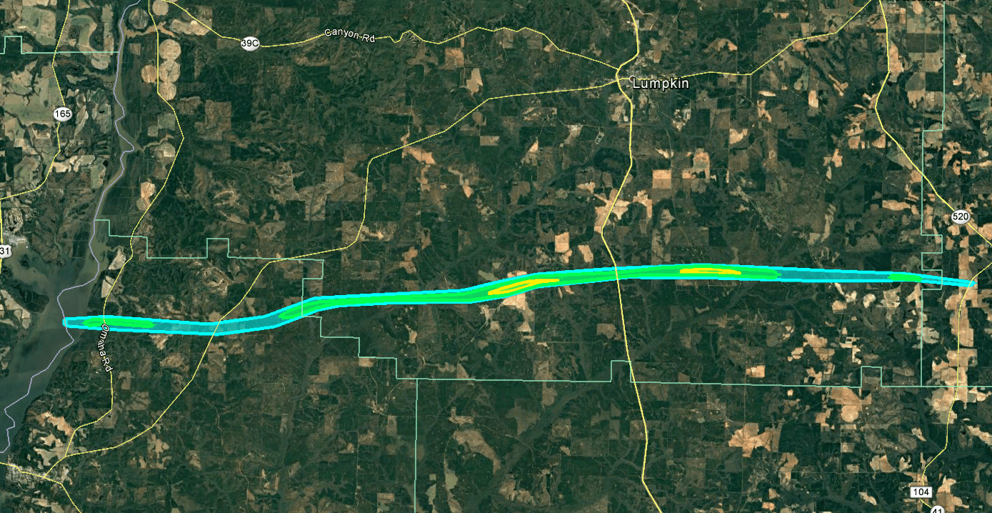
Entering Stewart County, the tornado crossed mainly forested areas with numerous large trees snapped or uprooted. Ground surveys were difficult the first few miles into Stewart county due to inaccessible roads, however radar data continued to confirm a tornado. The supercell/tornado made a slight turn to the northeast crossing
Wesley Chapel Road, and as it approached Philadelphia Road, the tornado reached its maximum intensity (and width), destroying multiple large metal-framed barns and moving several large pieces of farming equipment, including a cotton picker. In addition, a single-family home had its entire roof and most exterior walls pulled apart. A family of two with 3 dogs survived the tornado in their hallway with no major injury. Also near this location, just east of John Logan Road, several campers were flipped over and destroyed. No reports of injuries with the campers.
The strong tornado continued east-northeast crossing US/GA Hwy 1/27. Near this location it was mainly trees that were either snapped or uprooted within about 600-700 yard swath. Just east of this location, along CR 145, the tornado ripped hundreds of large trees up, snapping many of them near the base. This was another area of EF-2 damage based on the extensive tree damage. Following this point, the tornado began to cycle down and weaken but still caused damage to a number of trees between CR 148 and Goodwins Pond Road as it approached the Webster county line. Just into Webster County, along SR 41 and Goodwin Cutoff Rd, the tornado finally lifted with just a few tree branches snapped. In a large open field west of Goodwin Cutoff Rd, a portion of a large irrigation system was flipped over. No further damage was seen or reported east of the SR 41/Goodwin Cutoff Rd.
|
|
|
|
|
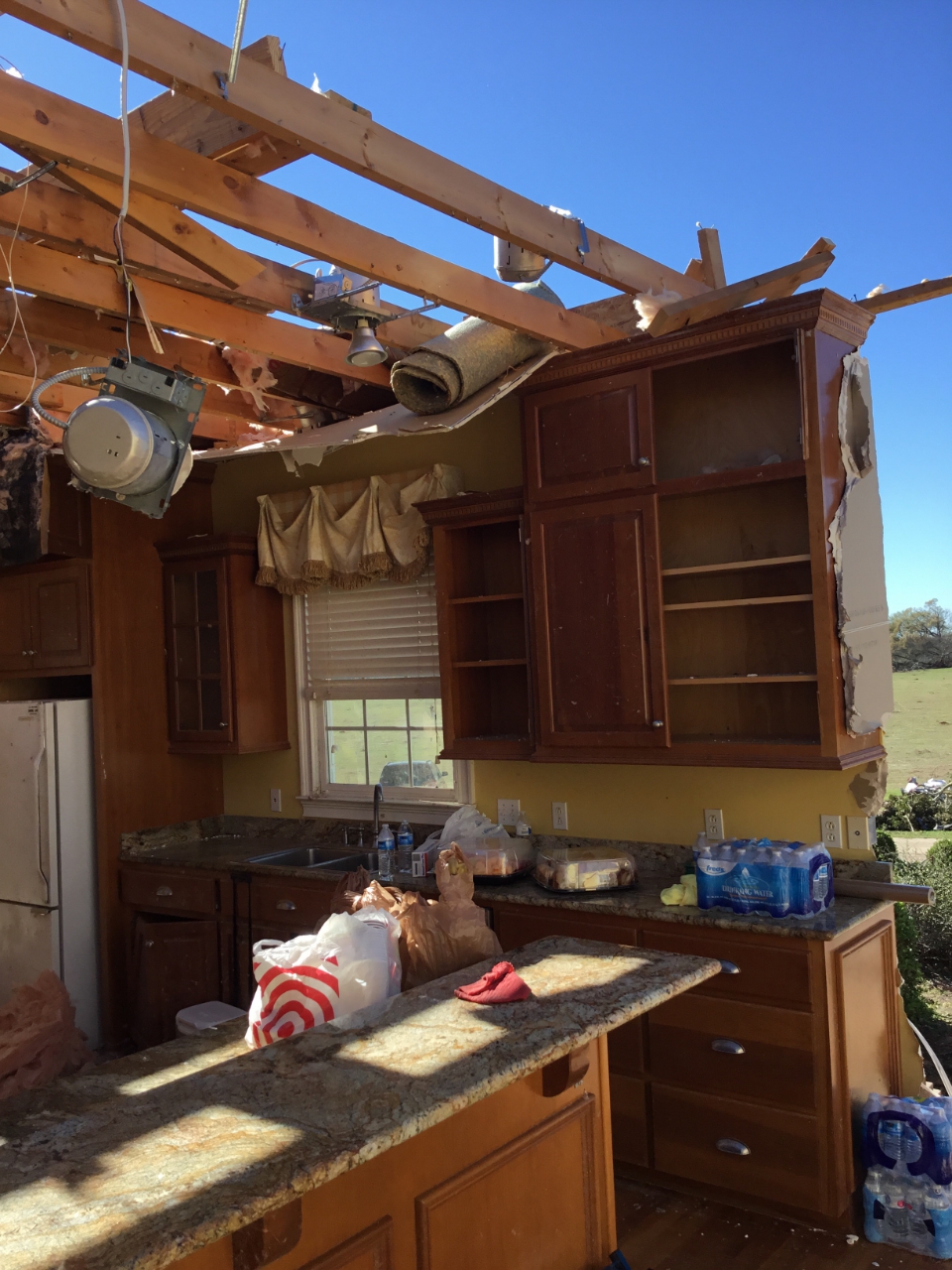
| The entire roof was ripped off this residence. | Just a few walls were left standing in this home. |
|
|
 |
| Reflectivity (5:16 PM EST) | Velocity (5:16 PM EST) |
 |
| Correlation Coefficient showing the presence of lofted debris (5:16 PM EST) |
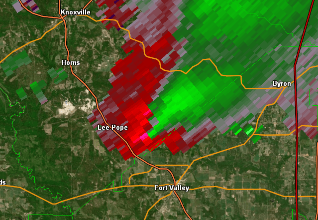
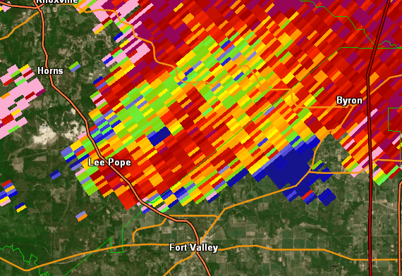
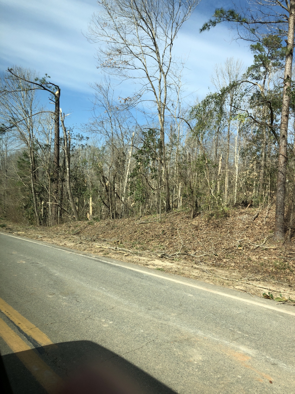
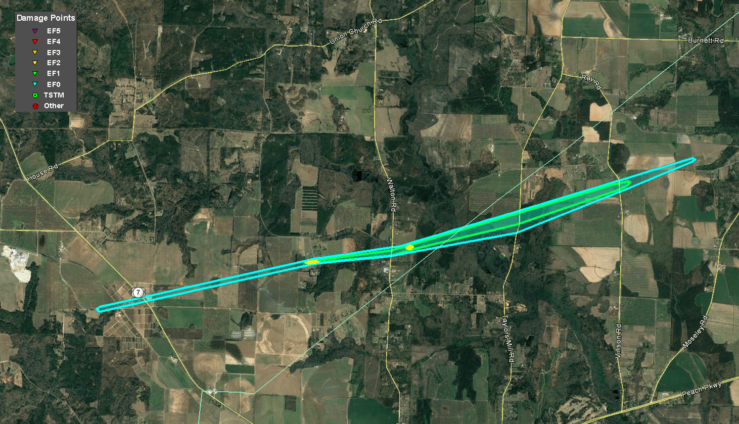
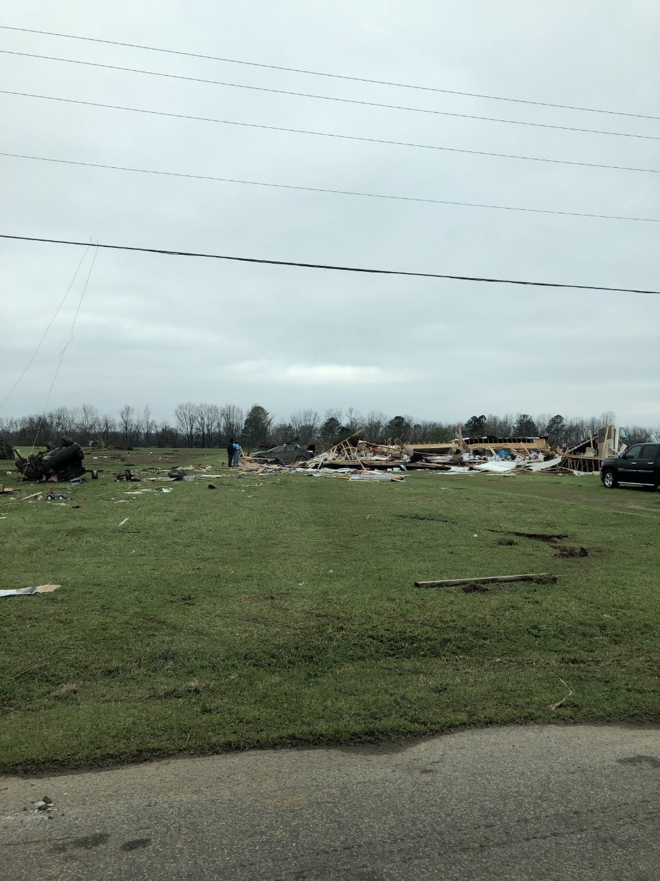
A fast-moving supercell thunderstorm produced a tornado in eastern Crawford County which began along Lee Pope Road as an EF-0 tornado where large pine trees were uprooted. The tornado continued moving east-northeastward with a relatively narrow width of around 90 yards upon reaching Greer Road, at which point winds increased into the low-end EF-2 range. A mobile home on Greer Road was flipped and demolished, and a vehicle was flipped and rolled. One woman inside the mobile home sustained a broken ankle when the home was destroyed. The tornado briefly weakened to an EF-1, downing trees as it crossed Walton Road, before reaching low-end EF-2 intensity for a second time along Wesley Chapel Road. A home at this location had its roof completely removed and some exterior walls collapsed. A neighboring home sustained roof damage from the large amount of flying debris. The tornado again weakened to EF-1 intensity as it crossed into Peach County, downing or uprooting a number of trees along Taylors Mill Road where its maximum width was achieved. Pecan farming equipment was overturned and a farming shed was destroyed as the tornado crossed Vinson Road. The tornado lifted after downing pecan trees along Oak Way.
|
|
|
|
|
| A destroyed mobile home (right) and flipped car (left). | The roof was ripped off this residence. |
|
|
 |
| Reflectivity (3:17 PM EST) | Velocity (3:17 PM EST) |
 |
| Correlation Coefficient showing the presence of lofted debris (3:17 PM EST) |
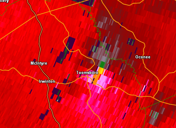
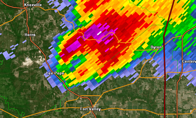
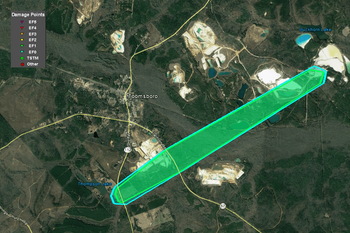
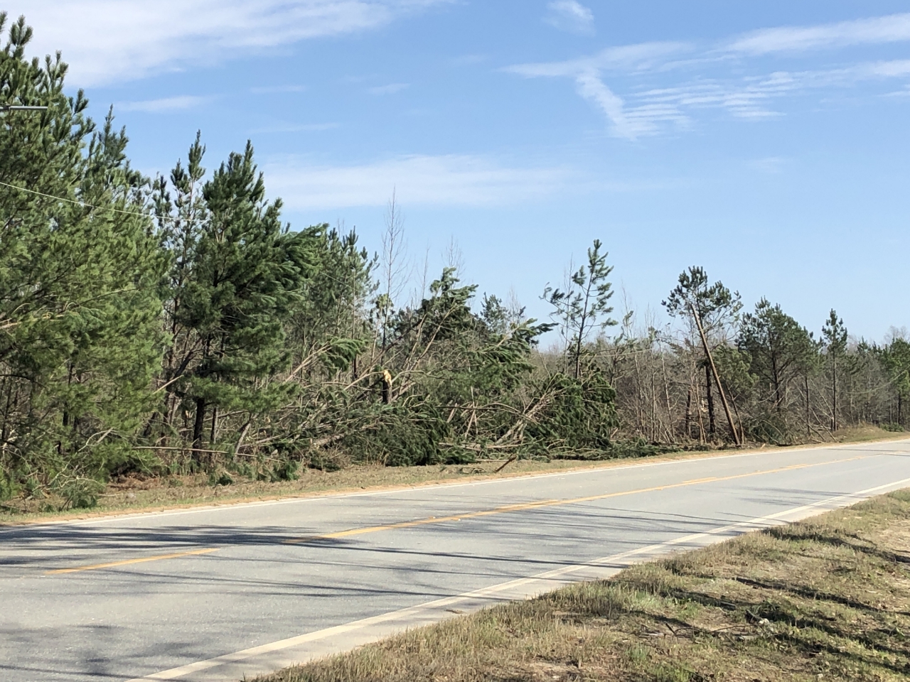
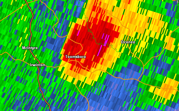
The same supercell thunderstorm that produced the Crawford/Peach and Twiggs County tornadoes produced a third tornado in eastern Wilkinson County. The tornado touched down south of Toomsboro just west of Highway 112 (Nickelsville Toomsboro Road) and quickly reached EF-1 strength, downing and snapping trees along Highway 112. The tornado continued northeastward, reaching its maximum width as it crossed Highway 57 (Irwinton Road). Numerous trees were snapped and uprooted in this area. From this point, the tornado traversed a very rural wooded area and reached the Dixie Mine, where the emergency manager reported numerous trees were snapped and uprooted, and some roofing damage occurred to buildings at the mine site. The tornado track then ended in a very remote and inaccessible woodland area near the Oconee River.
|
|
|
|
  |
| Multiple trees were downed along Irwinton Road. | Multiple trees were snapped along Irwinton Road. |
|
|
 |
| Reflectivity (4:20 PM EST) | Velocity (4:20 PM EST) |
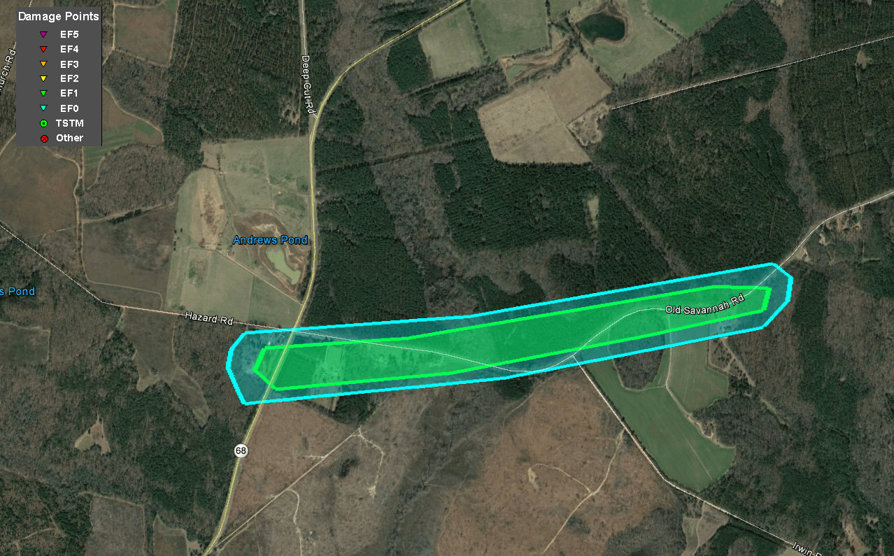
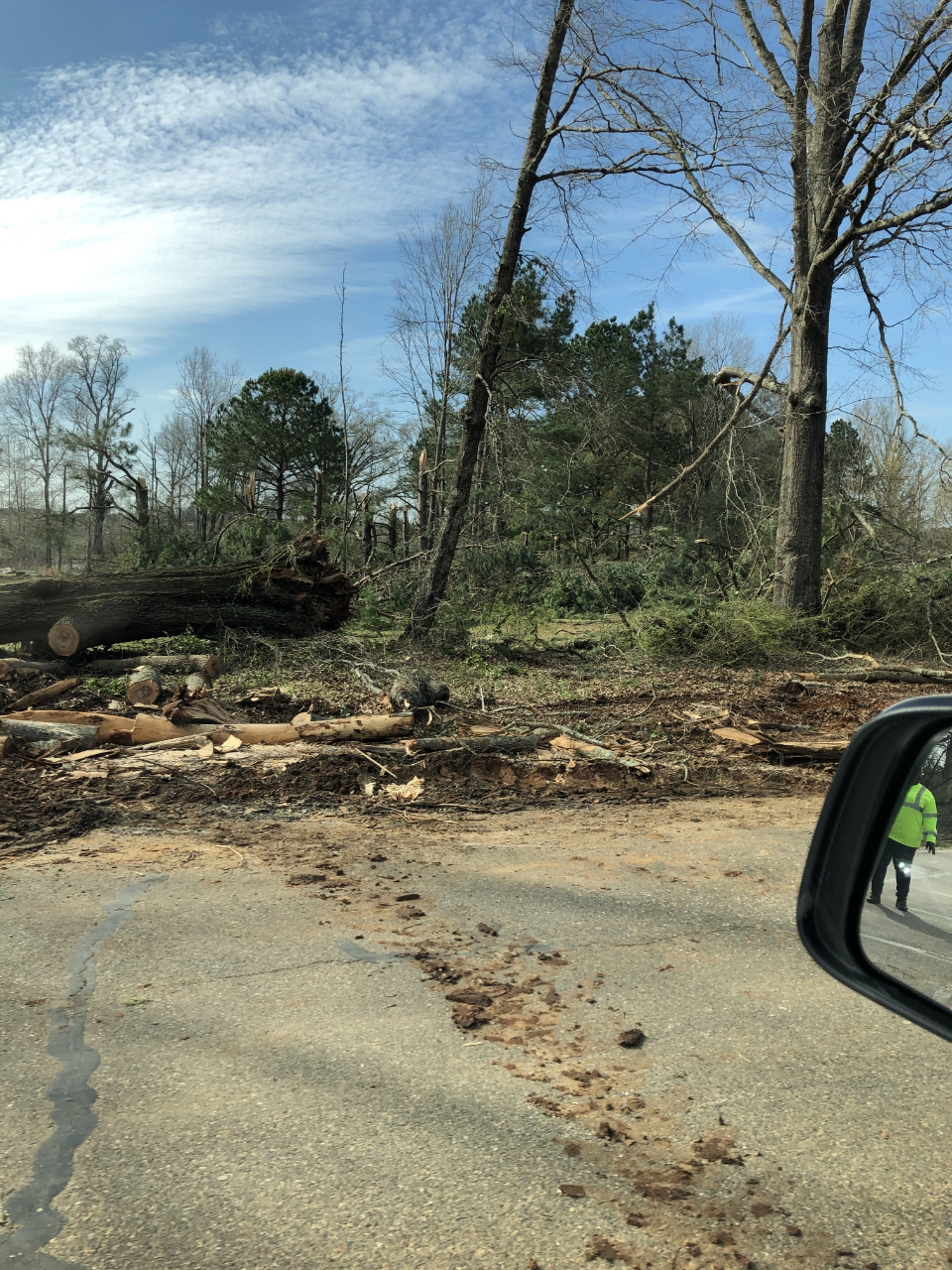
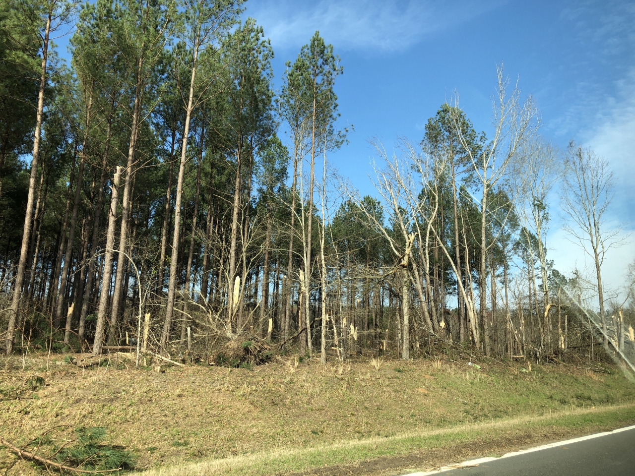
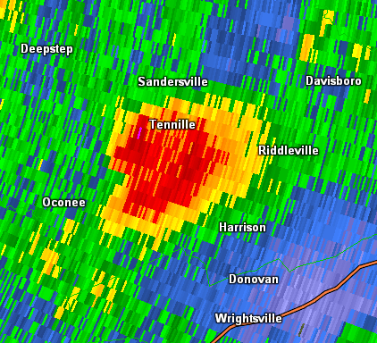
The ongoing supercell thunderstorm that had intermittently produced tornadoes along its path produced another brief EF-1 tornado in Washington County. The tornado touched down along GA-68 just south of Hazard Rd where a large number of trees were snapped or uprooted. The tornado then continued east-northeastward along Old Savannah Road, snapping and downing numerous trees along the roadway before lifting.
|
|
|
|
|
| Trees were uprooted along Balls Ferry Road. | Trees were snapped and uprooted along Old Savannah Road. |
|
|
 |
| Reflectivity (4:36 PM EST) | Velocity (4:36 PM EST) |
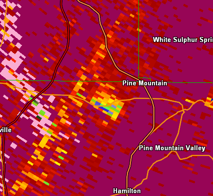
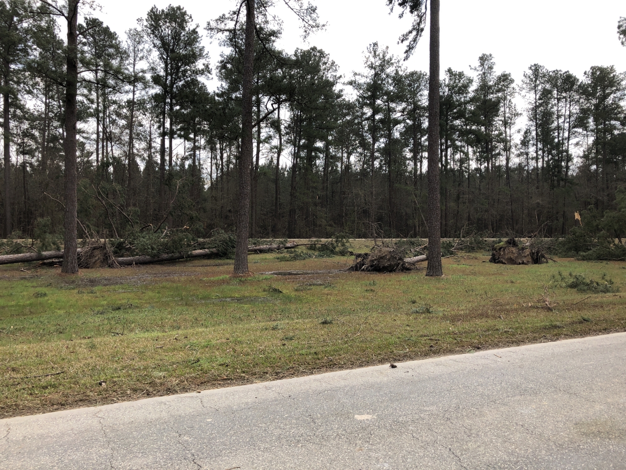
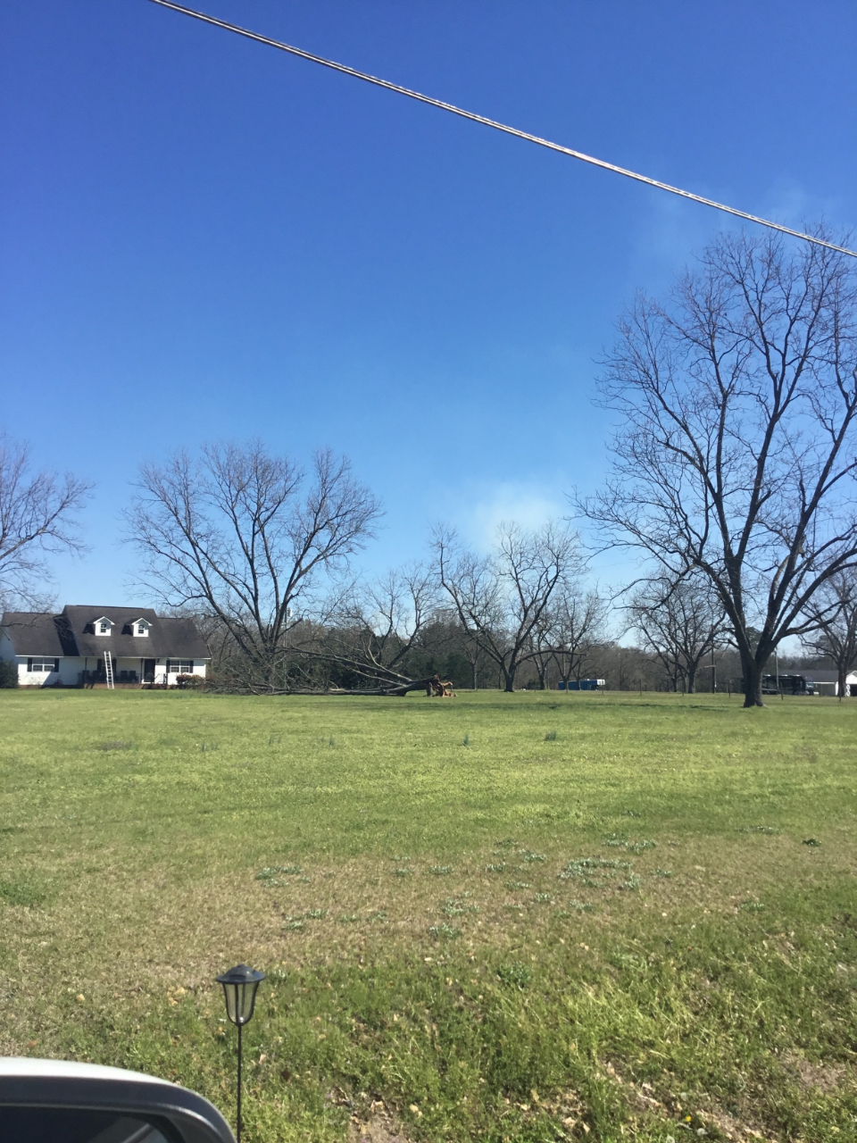
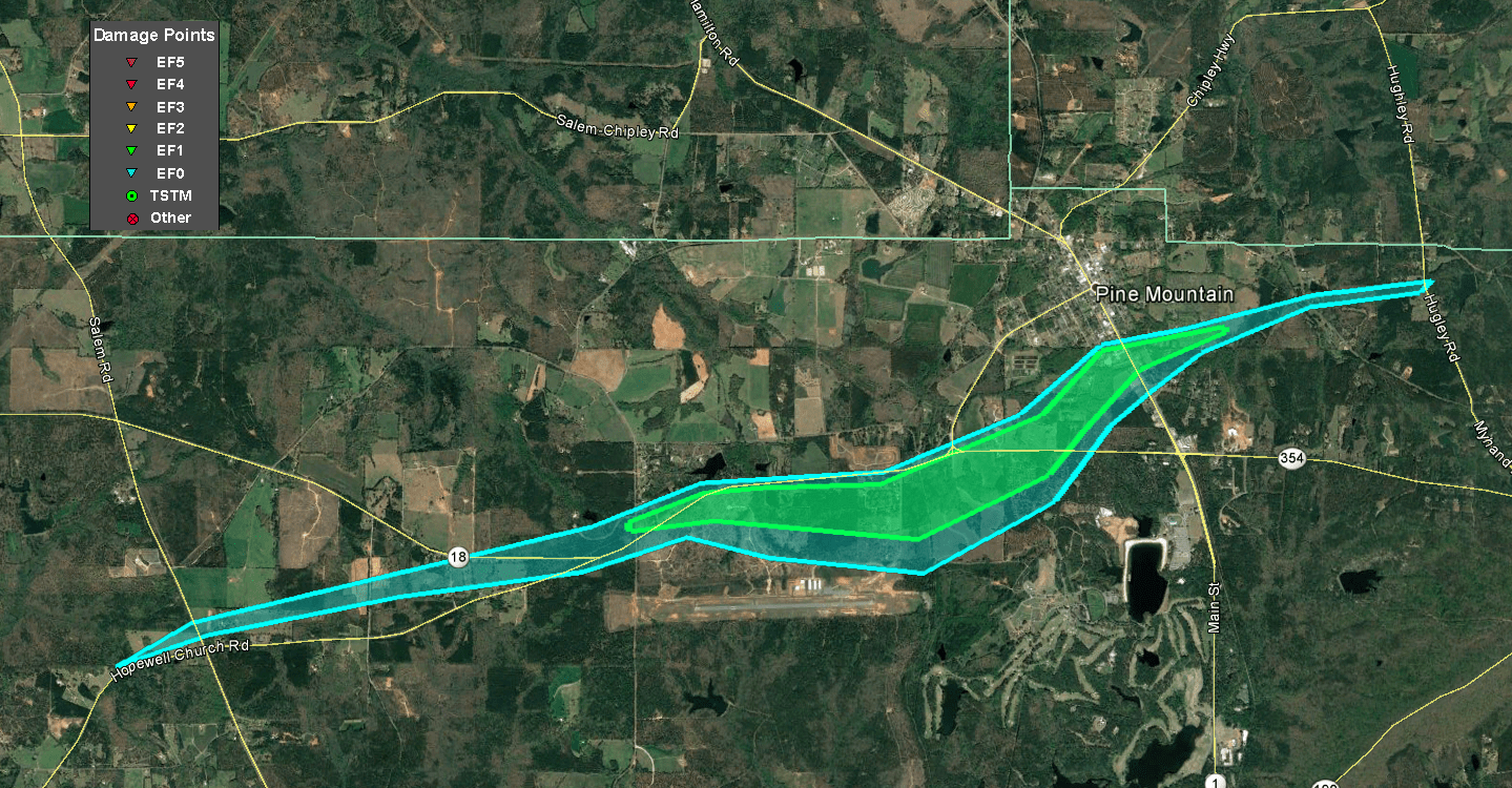
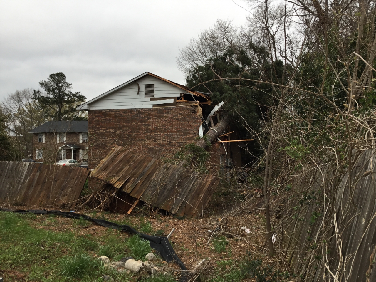
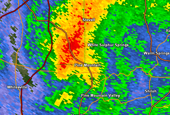
A supercell thunderstorm moved into northern Harris county and produced a tornado which began just west of the intersection of Hopewell Church Rd and Hamilton Pleasant Grove Rd. As the tornado traveled east-northeast along GA-18, the tornado intensified downing hundreds of trees, several falling on homes. As the tornado approached the city of Pine Mountain, the width of the tornado increased to near one-half mile but fortunately only increased to a maximum intensity of 100 mph as it moved across the south parts of the city. A large tree fell onto an apartment on S. King Ave destroying one of the rooms on the second floor. The tornado weakened as it continued east before lifting just west of the intersection of Davis Lake Rd and Cold Springs Rd.
|
|
|
|
  |
| A tree fell into an apartment on South King Ave. | Trees were reported down on several homes. |
|
|
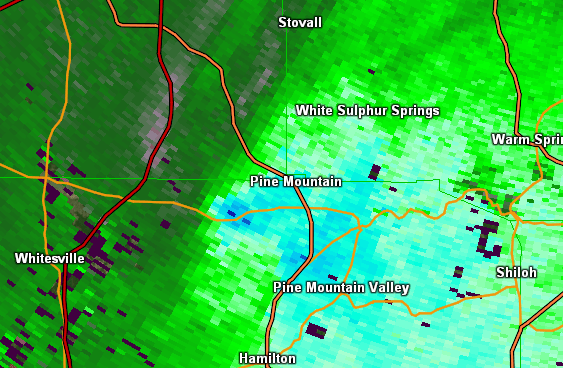 |
| Reflectivity (4:22 PM EST) | Velocity (4:22 PM EST) |
 |
| Correlation Coefficient showing the presence of lofted debris (4:23 PM EST) |
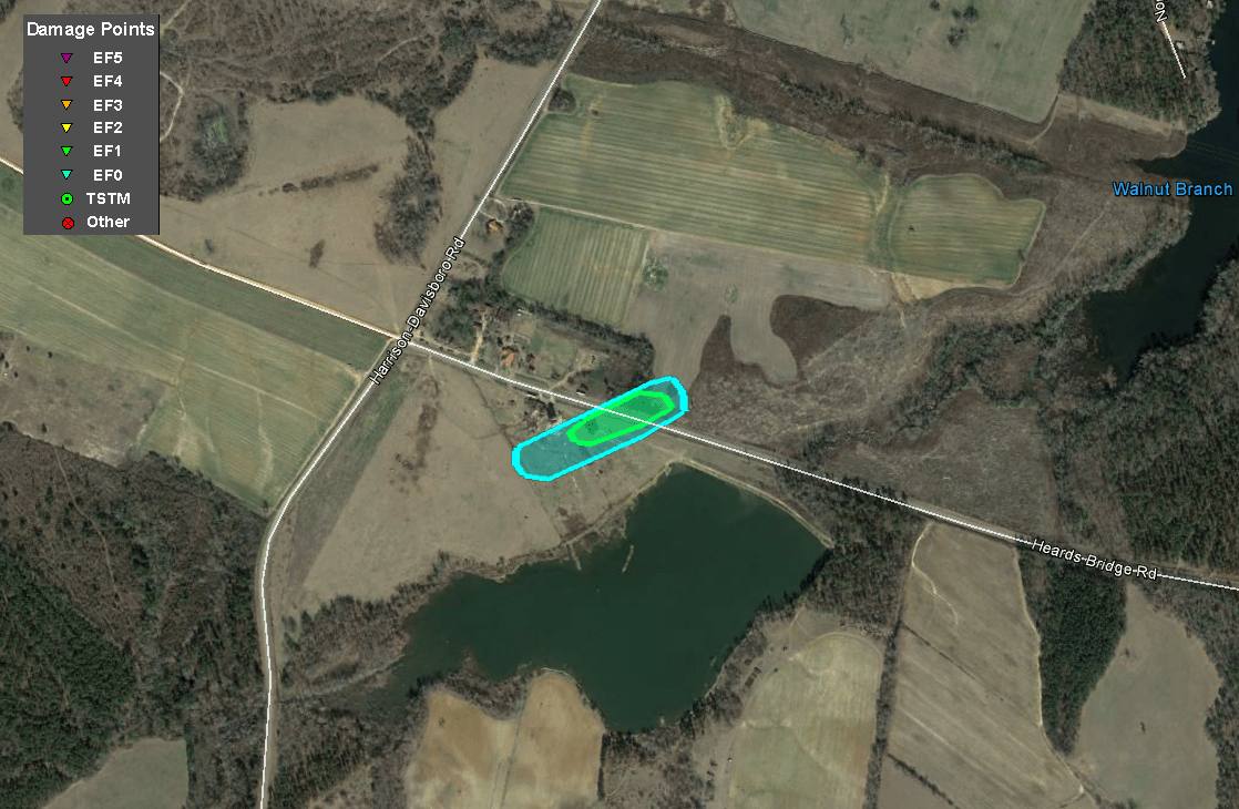
The long-lived supercell thunderstorm that produced a other tornadoes along its track produced a final very brief tornado in Washington County. The EF-1 tornado touched down just south of Heards Bridge Road and impacted a farm outbuilding and an old reinforced concrete silo. The silo collapsed, and the concrete debris scattered across a field, impacting and downing nearby power lines. The tornado lifted shortly after causing this damage with no other damage found downstream.
|
|
|
|
| A farm outbuilding and old concrete silo was destroyed along Heards Bridge Road. |
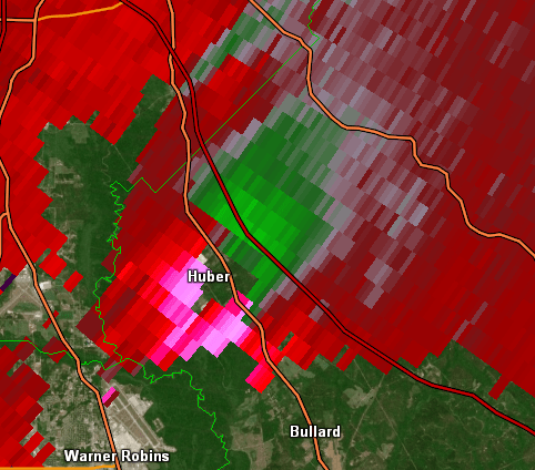
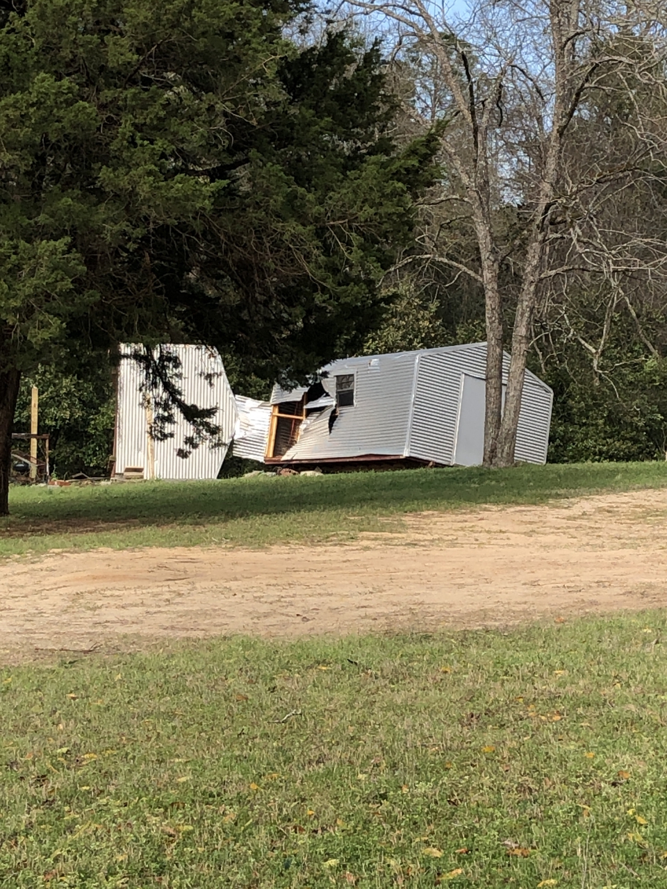
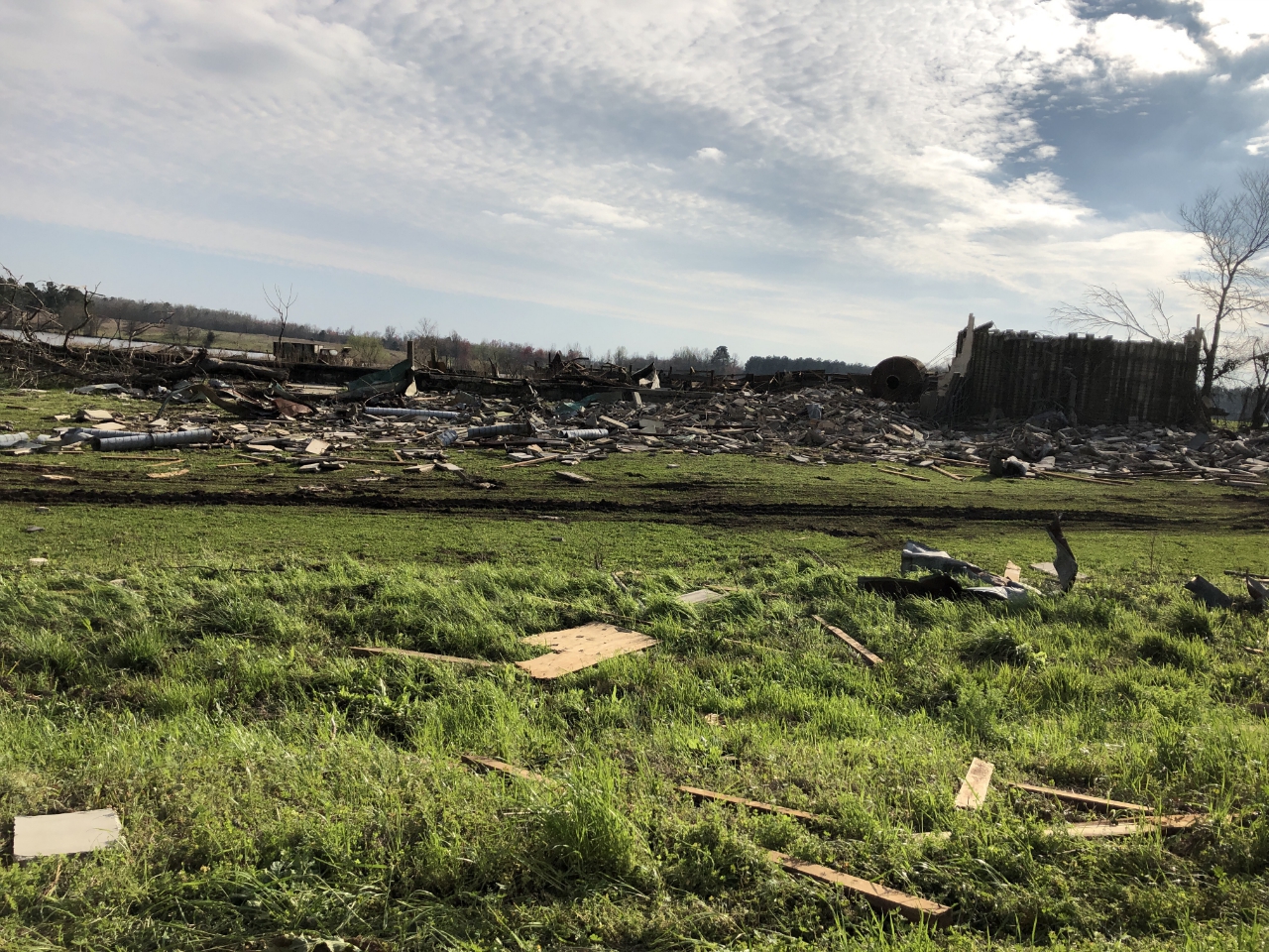
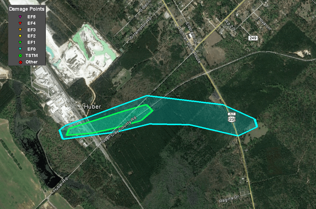
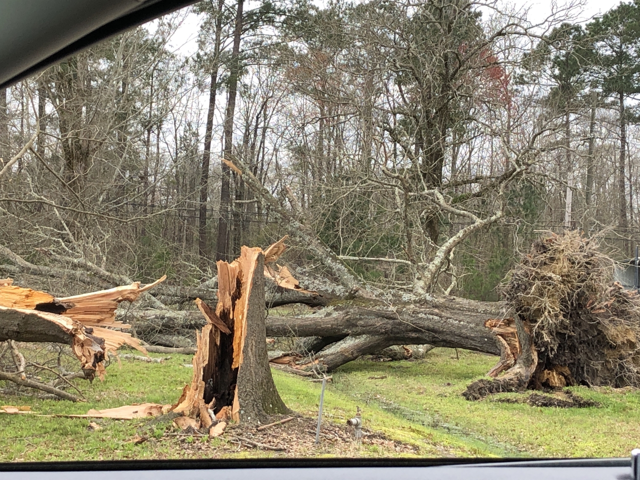
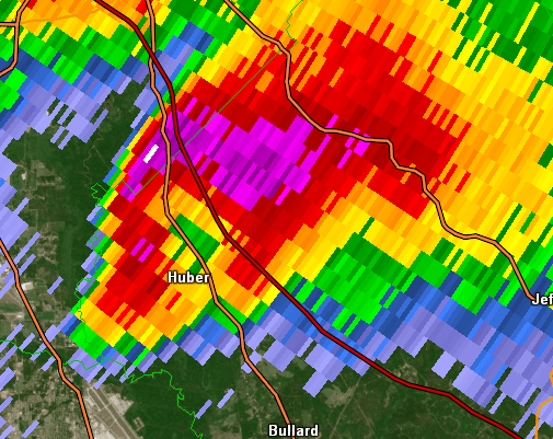
The same supercell that produced the earlier Crawford and Peach County tornado produced a second tornado after crossing into Twiggs County in the small community of Huber. The tornado touched down very near the KaMin factory on Huber Road where a number of large trees were snapped or uprooted. The tornado then produced further EF-1 damage between Huber Road and Huber Clay County Road where a large number of pine trees were snapped or uprooted. A number of other trees were snapped or uprooted near the Chance Hill Church on Cochran Short Route (US-23). A pine tree was downed on a house near this location as well before the tornado lifted shortly thereafter.
|
|
|
|
  |
| Hardwood trees were snapped and uprooted along Huber Road. | Softwood trees were uprooted along Huber Road. |
|
|
 |
| Reflectivity (3:42 PM EST) | Velocity (3:42 PM EST) |
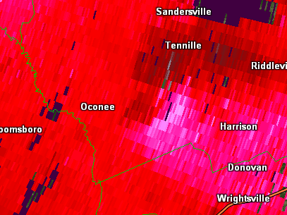
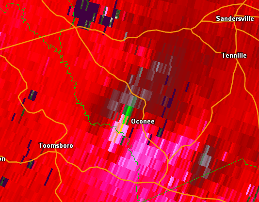
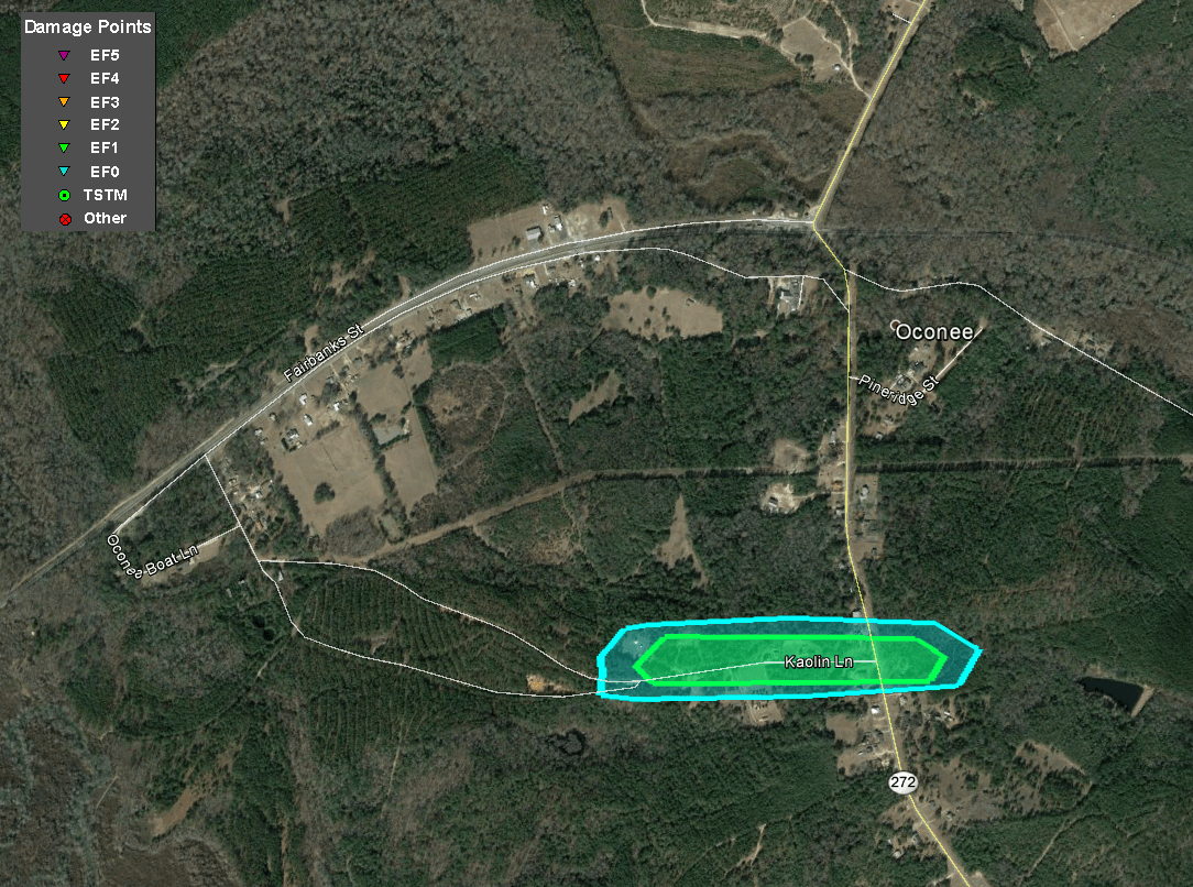
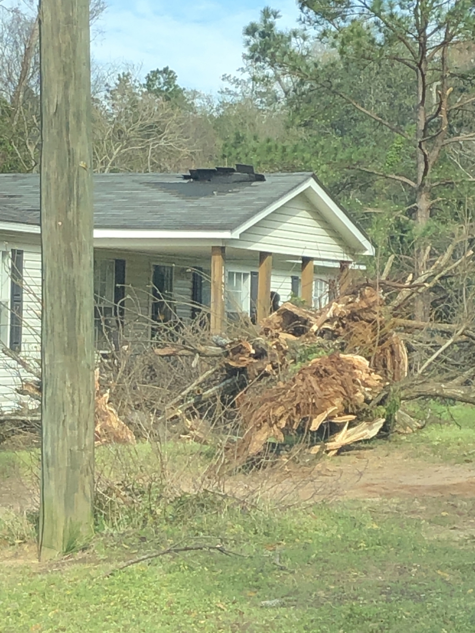
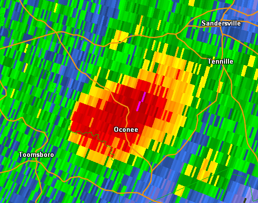
After producing the tornado in eastern Wilkinson County near Toomsboro, the ongoing supercell thunderstorm produced another brief EF-1 tornado in the small community of Oconee in Washington County. The tornado tracked along Kaolin Road, downing and snapping a number of trees. Sections of shingles were removed from the roof of a home on Kaolin Road and a backyard shed at the same home was flipped and heavily damaged. The tornado downed a large tree on a home at the corner of Kaolin Road and Highway 272 and downed a number of other trees alongside Highway 272 before ending just east of the highway.
|
|
|
|
  |
| A home lost several shingles and a tree was uprooted. | A shed was damaged. |
|
|
 |
| Reflectivity (3:25 PM EST) | Velocity (3:25 PM EST) |
|
|
|
|
|
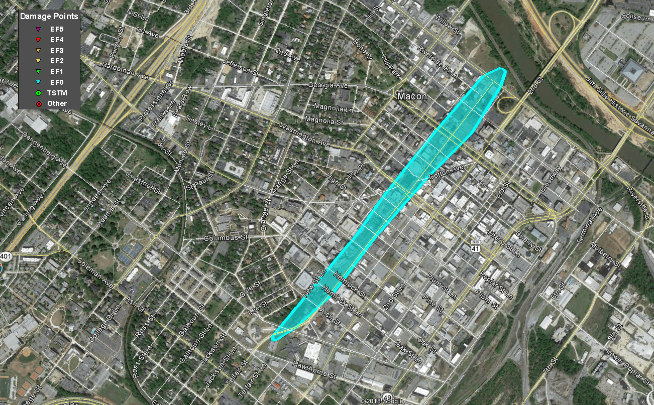
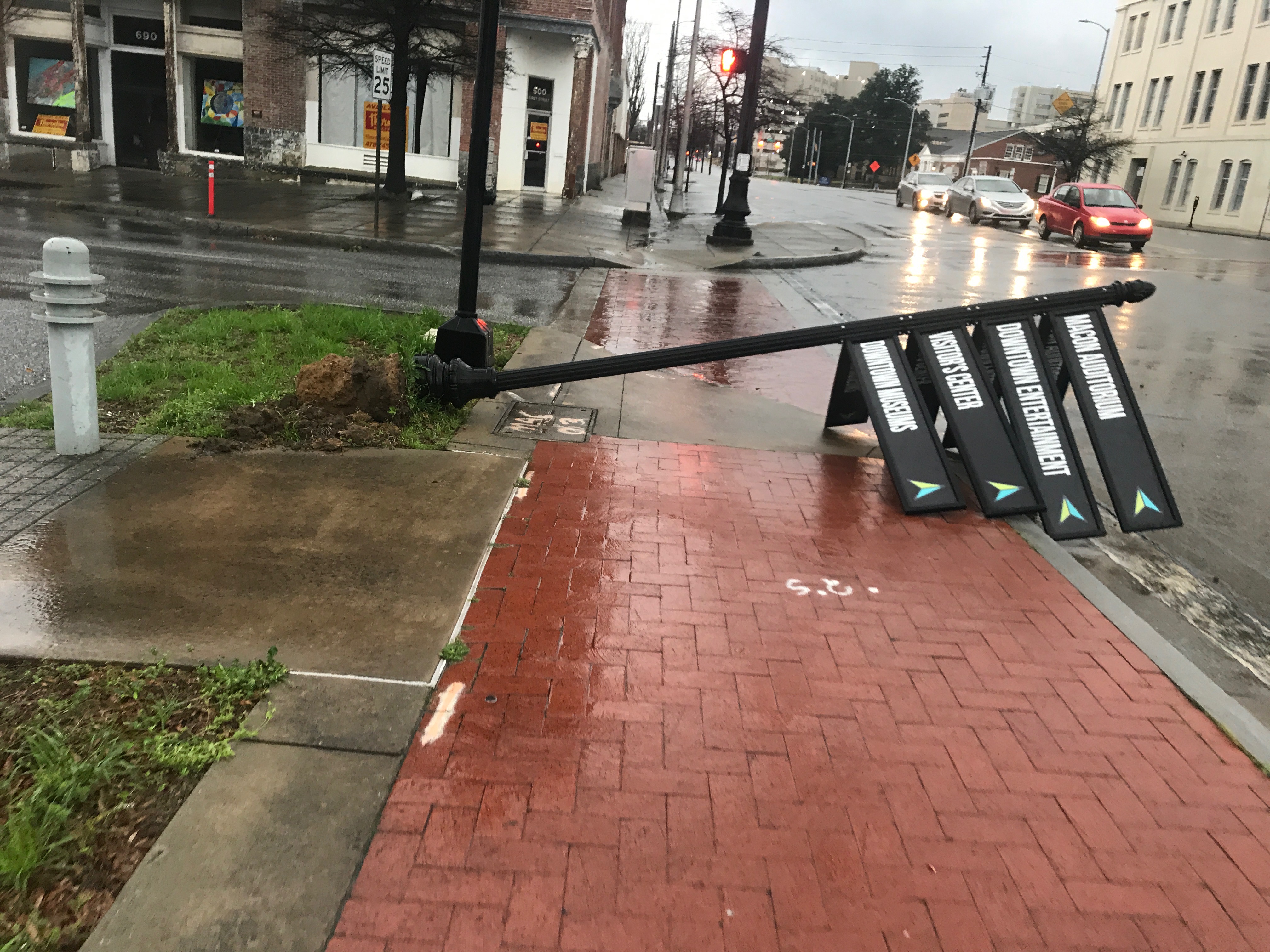
| This large flagpole was bent a few feet from its base. | These street signs were blown down in downtown Macon. |
|
|
 |
| Reflectivity (4:36 PM EST) | Velocity (4:36 PM EST) |
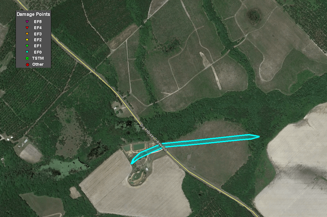
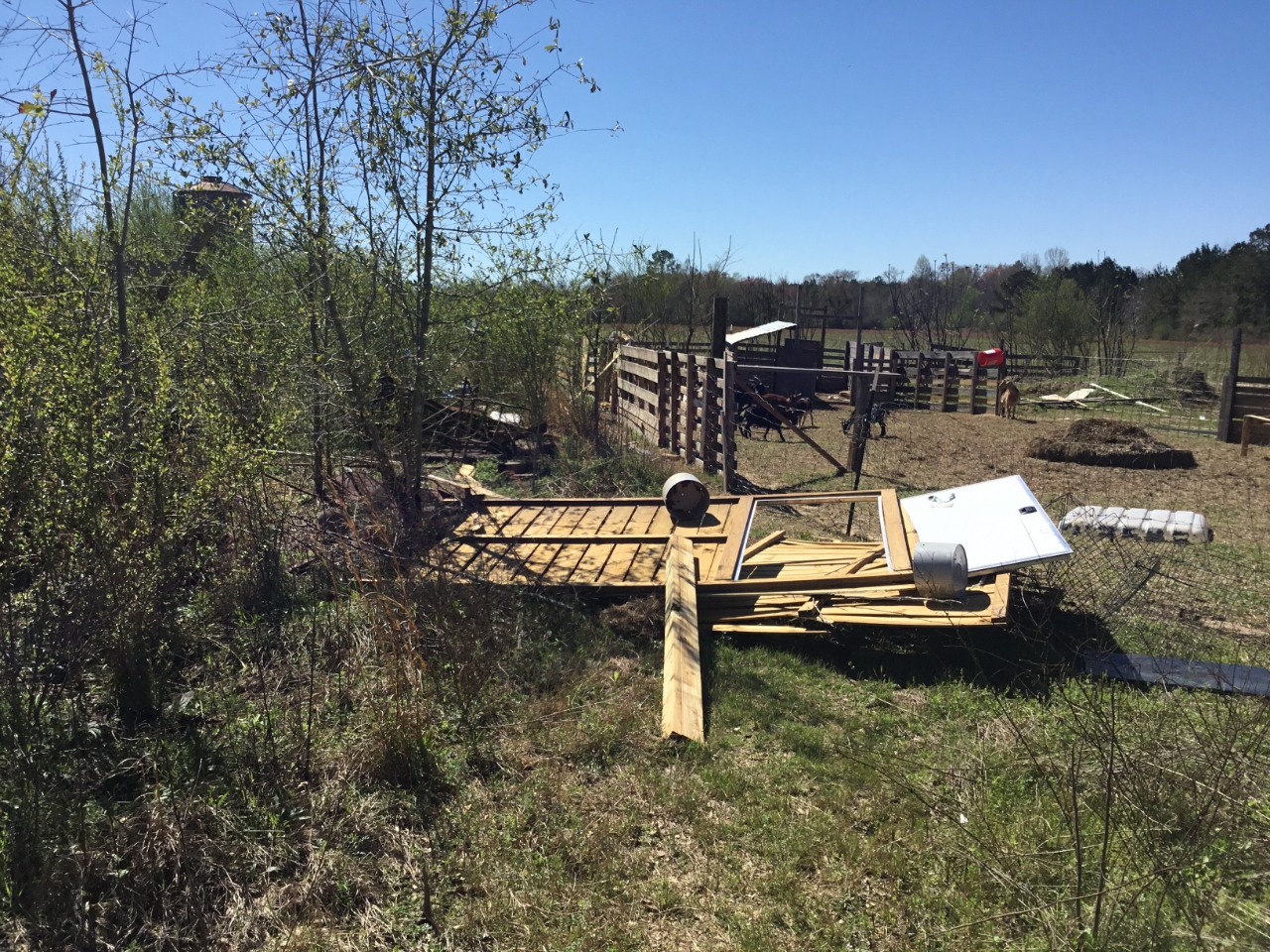
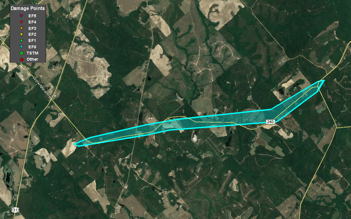
The same supercell that produced the tornado east of the Workmore community in Telfair County also produced another short-lived EF-0 tornado 5 minutes later further south at the tip of the reflectivity hook/appendage where strong rotation was also observed. This tornado touched down about 3/4ths of a mile northwest of the intersection of Big Horse Creek Rd and East River Rd where it lifted and threw a chicken house 50 feet into a shed. Several trees were also snapped along the path before it lifted less than 1/2 mile from where it started.
|
|
|
|
|
| A chicken house was lifted and thrown 50 feet into a shed. | A chicken house was destroyed and the shed was damaged. |
|
|
 |
| Reflectivity (4:09 PM EST) | Velocity (4:09 PM EST) |
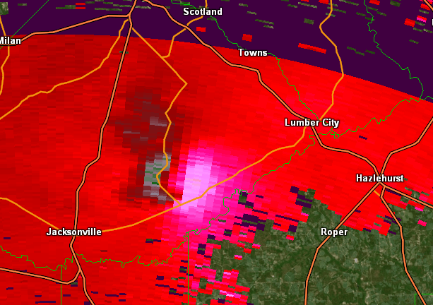
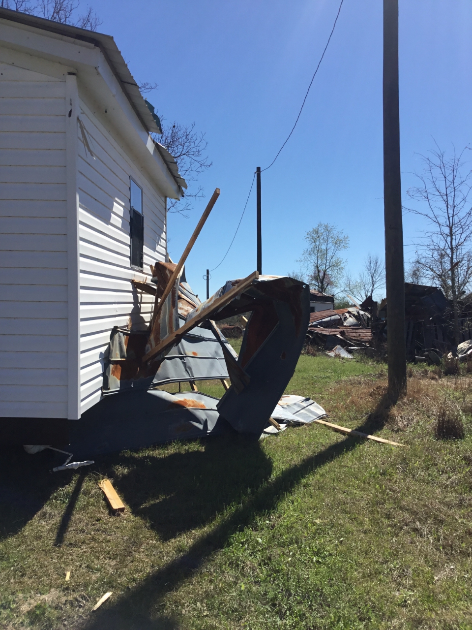
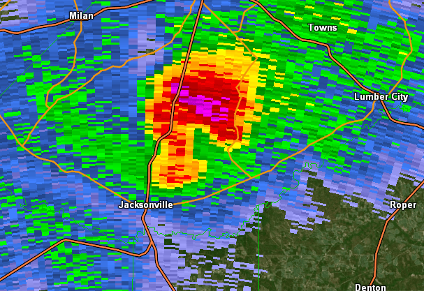
A supercell in Ben Hill county moved into Telfair county around 330 PM EST and produced a tornado just south of the core of the storm near the Workmore community south of McRae. The tornado began near the intersection of Workmore Milan Rd and Macedonia Church Rd where the porch off of a home was completely ripped out of its concrete footings and thrown 100 yards. Minor roof damage also occurred to the house and wood power pole adjacent to the house was also snapped. The tornado traveled ENE along Macedonia Church Rd downing around a dozen trees before lifting near the intersection with Big Horse Creek Rd. The Valdosta WSR-88D /KVAX/ did observed a weak Tornado Debris Signature /TDS/ with this storm and interestingly may have preceded tornadogenesis by 1-2 minutes.
|
|
|
|
  |
 A snapped tree with other trees with snapped branches on Macedonia Church Road. A snapped tree with other trees with snapped branches on Macedonia Church Road. |
This home lost its covered car-port and a power pole was snapped. |
|
|
 |
| Reflectivity (4:06 PM EST) | Velocity (4:06 PM EST) |
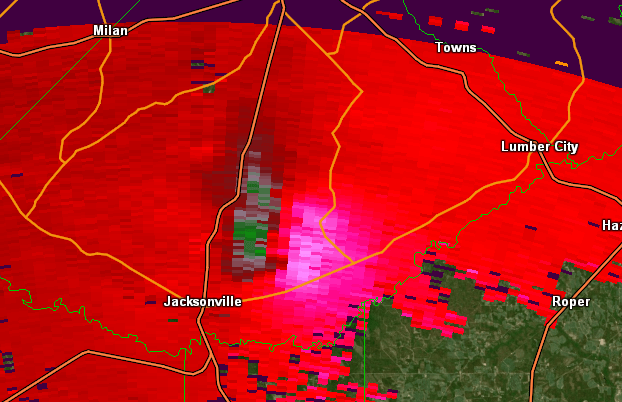
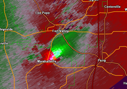
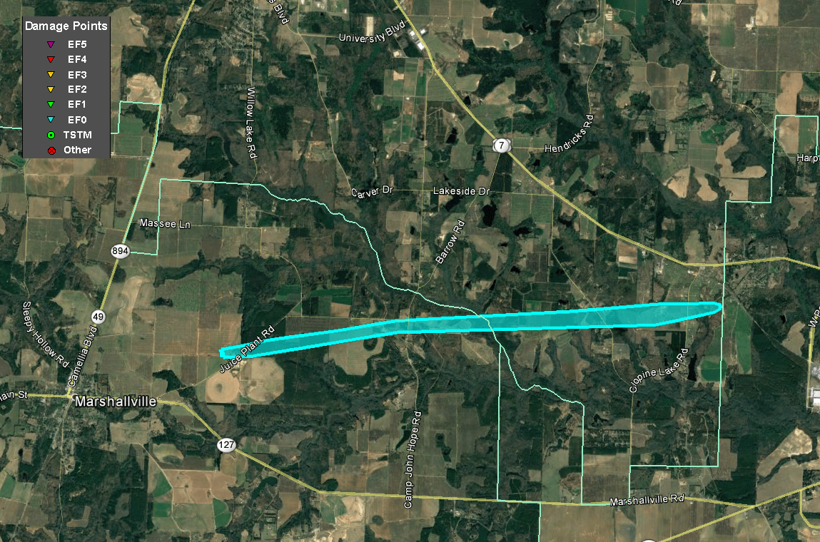
The same supercell thunderstorm that began in Chattahoochee County tracked across Marion County and dropped a brief tornado in
Taylor County produced another tornado which began in Eastern Macon County along Juice Plant Road east of Marshallville. A few trees were
snapped off of Juice Plant Road near the start of the track.  The storm continued ENE just south of Juice Plant Road snapping a few
trees along Finch Lane where one tree fell across the corner of a home. Several other trees were snapped in a treeline behind the home.
The storm crossed Camp John Hope Rd where a couple trees were dowed before tracking into Southern Peach County.  Trees were snapped along
Norwood Spring Road along with damage to an metal outbuilding at a residence to the east of the road. Metal was peeled and lifted into
nearby trees. Further east along Clopine Lake Road, at least 2 dozen trees were either snapped or uprooted.  A mobile home sustained
minor roof damage and damage to the skirting.  A metal outbuilding had one of its 3 south facing doors blown off and thrown onto a nearby
building and a 30 foot wooden fence was snapped off at the posts. A homeowner along the road recalls the storm coming through and
hearing itas it passed by and told us they retrieved a lot of insulation off of their property. The survey team could not determine where
the insulation came from but assumes it came from an unsurveyed structure on Norwood Springs Rd.  A neighbor to the property showed
photos of the wall cloud as it approached. The storm continued east before lifting near the Houston/Peach County line.
|
|
|
|
 |
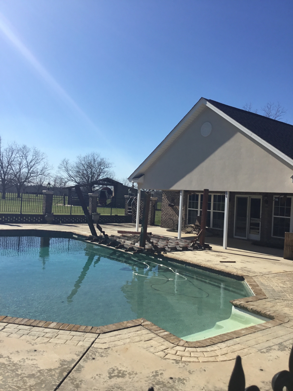
| This outdoor pergola was blown across the back patio of this home. |
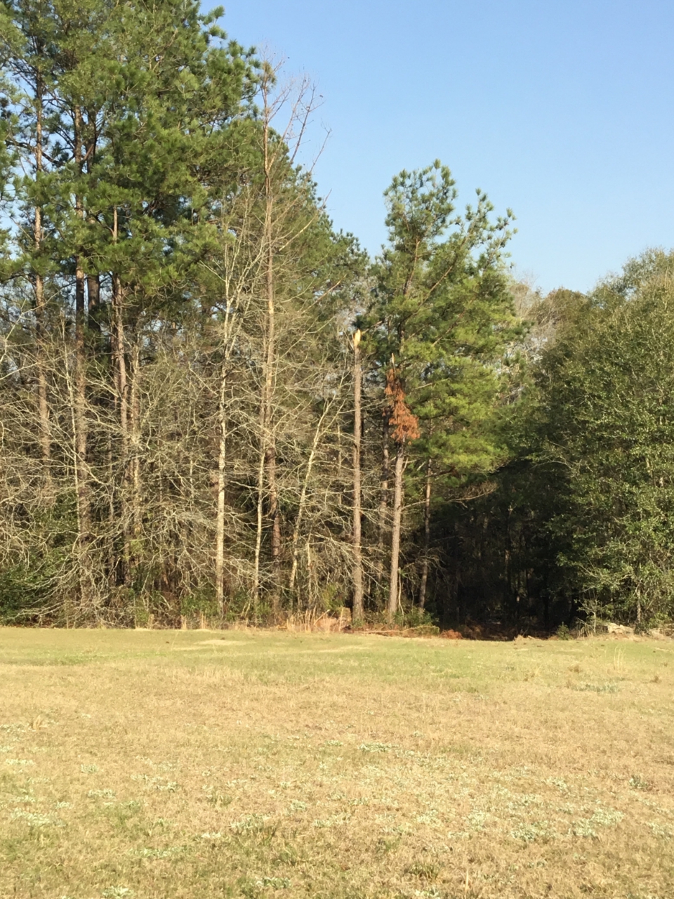
Pecan trees such as this one were downed along the tornado's path. |
|
|
 |
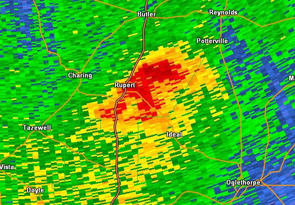
| Reflectivity (4:43 PM EST) | Velocity (4:43 PM EST) |
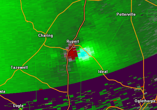
A supercell thunderstorm that began in Chattahoochee County tracked across Marion County and into Taylor County before dropping its first tornado. While very
weak, both radar evidence of a TDS and damage on the ground confirm an EF0. The tornado touched down first just east of US 19 south of Rupert and tracked
ENE crossing Prosperity Church Rd causing sporadic tree damage. The storm tracked across an uninhabited portion of Taylor County along the Macon County
line before crossing County Road 194 where several trees were snapped at a residence.  The storm lifted just east of US 90.
|
|
|
|
| This large tree was snapped near its top. |
|
|
 |
| Reflectivity (4:19 PM EST) | Velocity (4:19 PM EST) |


 Follow us on YouTube