May 11, 2008 Laurens County |
 Back to main page for this event...
Mother's Day 2008 will be remembered by many in Georgia as a day of fury by Mother Nature. Severe thunderstorms plowed through portions of North and Central Georgia during the morning hours of May 11, 2008 resulting in damaging wind, large hail and several tornadoes. At least one person was killed by a tornado and several were injured. The damage was so extensive in some areas that Governor Sonny Perdue declared a state of emergency in six Georgia counties, and some schools were closed for a couple of days.
in Laurens County...
*** three tornadoes ***
*** two deaths...two injuries ***
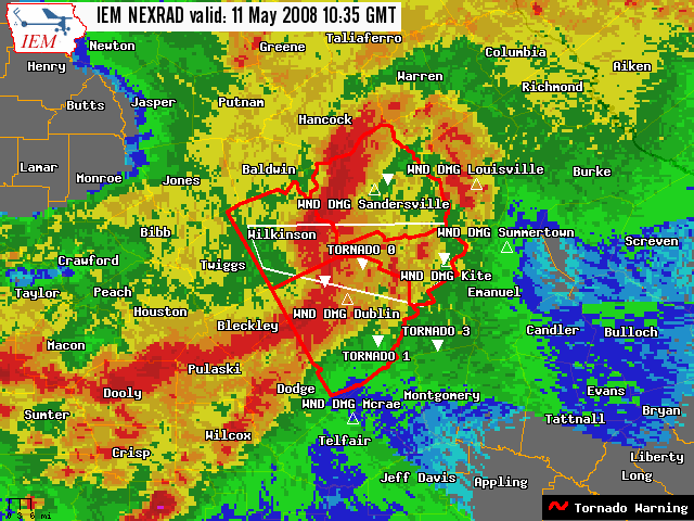 The strongest tornado touched down near the intersection of Old Macon Road and Oscar Wynn Road with an initial intensity of EF0. The tornado continued on an almost due eastward track and strengthened to EF2 intensity as it crossed U.S. Highway 441 in the 2700 block...about seven miles northwest of Dublin...near the intersection of Evergreen Road and U.S. Highway 441. A double-wide mobile home was destroyed at 2731 U.S. Highway 441...where a male in his early 50s was killed along with his wife. Their two grandchildren sustained non-life threatening injuries. Another home was damaged along Evergreen Road as the tornado continued at EF2 intensity. Sporadic damage to trees continued further eastward...but the tornado weakened to an EF0 as it crossed the Oconee River. The tornado once again strengthened to an EF2 as it crossed Buckeye Road in the 2100 block...and then weakened to an EF1 as it crossed New Buckeye Road in the 1500 block. EF2 damage to a home was observed at 2185 Buckeye Road...and EF1 damage to another home at 1533 Buckeye Road. The majority of the tornado path was ranked as EF0 tornado damage. The total path length of the tornado was approximately nine miles...with a maximum path width of 250 yards as it crossed U.S. 441 near Evergreen Road.
All together with this tornado...there were two mobile homes destroyed...six other homes with major damage...some shifted off their foundations...at least one with its roof missing...and many with minor roof or siding damage. Numerous sheds and outbuildings were destroyed. Many trees were either uprooted or snapped off along the path of the tornado. In addition...widespread non-tornadic wind damage was reported throughout much of the county...primarily along and south of the track of the tornado...all the way from the Twiggs County line on the west side to the Johnson County line on the east side.
Another tornado, rated EF1 developed in extreme northern Laurens County...1 mile west of Tuckers Crossroads...or about 9 miles west-southwest of Wrightsville at 644 am edt. Near Tuckers Crossroads...the tornado destroyed one mobile home...pushed a manufactured home off its foundation...and moved a truck 30 feet. The tornado downed numerous trees and damaged several homes in the Wrightsville area before lifting approximately 1 mile northeast of Wrightsville in Johnson County at 654 am edt. The path length was 10 miles and was up to 1/3 of a mile wide.
The third tornado touched down about 1 mile north of Lowery in southeast Laurens County. One mobile home was destroyed and numerous trees were snapped and uprooted. The damage path was about 0.5 miles long and maximum width was 200 yards wide.
| Samples of Damage Seen During Survey ( click images to enlarge ) |
||
|---|---|---|
![[ An unoccupied mobile home was rolled. ]](/images/ffc/events/20080511/laurenstor51108.jpg) An unoccupied mobile home was rolled. |
![[ Damage to a home on Evergreen Rd. ]](/images/ffc/events/20080511/laurenstor51108a.jpg) Damage to a home on Evergreen Rd. |
![[ One death and three injuries in this mobile home. ]](/images/ffc/events/20080511/laurenstor51108b.jpg) One death and three injuries in this mobile home. |
![[ There is a vehicle buried under those trees somewhere. ]](/images/ffc/events/20080511/laurenstor51108c.jpg) There is a vehicle buried under those trees somewhere. |
![[ Home damaged on Buckeye Rd. ]](/images/ffc/events/20080511/laurenstor51108d.jpg) Home damaged on Buckeye Rd. |
![[ Home pushed off of foundation. ]](/images/ffc/events/20080511/laurenstor51108e.jpg) Home pushed off of foundation. |


 Follow us on YouTube