 Back to main page for this event...
Mother's Day 2008 will be remembered by many in Georgia as a day of fury by Mother Nature. Severe thunderstorms plowed through portions of North and Central Georgia during the morning hours of May 11, 2008 resulting in damaging wind, large hail and several tornadoes. At least one person was killed by a tornado and several were injured. The damage was so extensive in some areas that Governor Sonny Perdue declared a state of emergency in six Georgia counties, and some schools were closed for a couple of days.
in Twiggs and Wilkinson Counties...
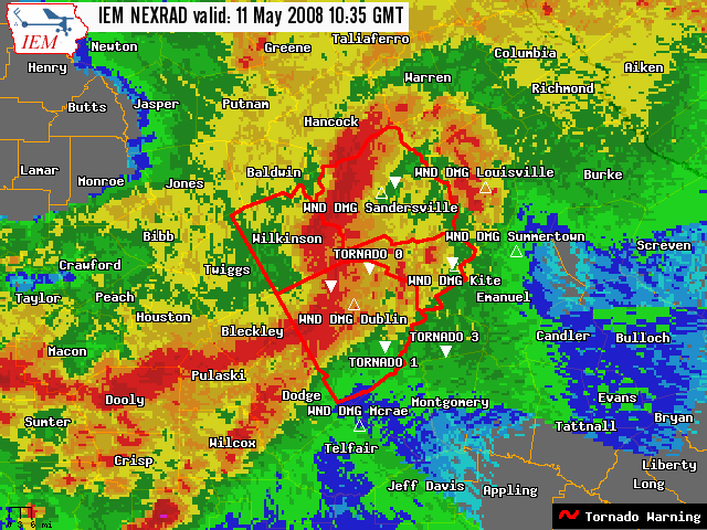 The storm which produced the Bibb County tornado spawned another EF1 tornado with winds up to 90 mph. The tornado touched down close to Fitzgerald near us Highway 80 and west of Myricks Mill Rd where a church had most of its roof blown off. It continued east into western Wilkinson County paralleling ga Highway 96 near us Hwy 441. A mobile home was damaged at Beaver Dam Road. The tornado lifted east of Long Branch Rd 8 miles southeast of Toomsboro. The total path length 25 miles and maximum width was 100 yards. Additional straight-line winds of 60 to 70 mph produced minor damage along and up to 3 miles south of the tornado track.
in Washington and Jefferson Counties...
An EF0 tornado touched down near Georgia Highway 15 and Mayview Road tracking east for approximately 33 miles through Jefferson County and into Burke County before lifting at 722 am. Many structures were damaged but most of the damage was minor. Maximum path width was 1/4 mile. Additional straight-line winds estimated at 60 to 70 mph caused damage along a 1 to 2 mile wide south of the tornado... causing moderate damage to structures in Louisville...north of Sandersville and north parts of Davisboro.
in Johnson and Emanuel Counties...
An EF2 tornado formed 1 mile northwest of Kite at 701 am edt... rolling a mobile home and damaging other homes and cars along us Highway 221 north of Kite. The most significant damage occurred along Minton Chapel Road...3 miles north of Kite where a mobile home was completely destroyed and its debris thrown up to 50 feet. A metal building in the same area had substantial wall...frame...and column anchor failures. The tornado lifted 1 mile west of Blundale in Emanuel County just north of Cordie Rd at 709 am edt. The tornado was rated EF2 with estimated winds of 130 mph...a maximum width 1/2 mile...and a total path length of 8 miles. In addition... Straight-line winds estimated up to 90 mph occurred along and up to 2 miles south of the tornado track producing widespread tree and primarily minor structure damage. A gymnasium in Kite did sustain masonry wall and roof damage. Several other structures and numerous trees were also damaged in the town.


![[ Mobile home flipped in Johnson County. ]](/images/ffc/events/20080511/johntor51108.jpg)
![[ Metal building destroyed in Johnson County. ]](/images/ffc/events/20080511/johntor51108a.jpg)
![[ Johnson County - where a mobile home once stood. ]](/images/ffc/events/20080511/johntor51108b.jpg)
![[ Johnson County - remnants of a mobile home. ]](/images/ffc/events/20080511/johntor51108c.jpg)
![[ Tree down on mobile home in Johnson County. ]](/images/ffc/events/20080511/johntor51108d.jpg)
![[ Church severely damaged in Twiggs County. ]](/images/ffc/events/20080511/johntor51108e.jpg)
 Follow us on YouTube