Overview
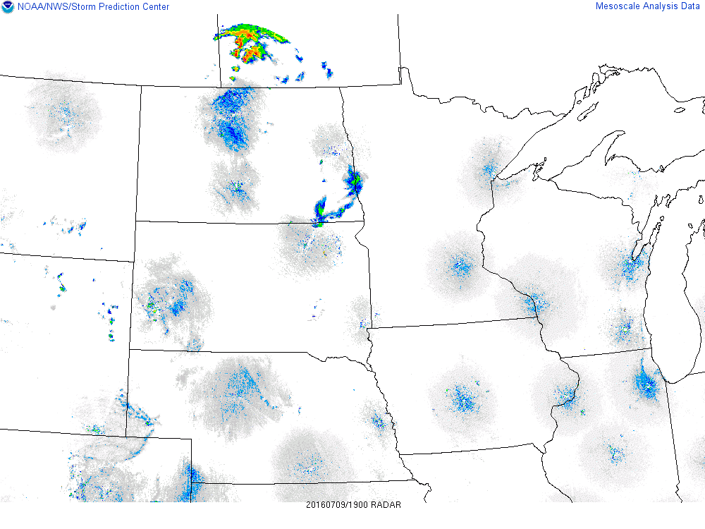
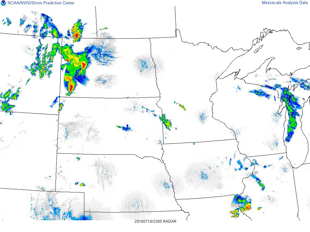
Multiple rounds of strong to severe thunderstorms impacted North Dakota and Minnesota Saturday afternoon (July 9) through Monday (July 11). The first round of storms developed across northern North Dakota Saturday afternoon and spread south and eastward across the area through Saturday Night, producing hail up to baseball size and damaging winds. The active weekend continued on Sunday as thunderstorms developed to the west and organized into an intense line that passed through the region late Sunday evening into early Monday morning, producing damaging winds and heavy rainfall. Areas of showers and thunderstorms persisted into Monday evening, most focused across far southeast North Dakota through Minnesota lakes country, resulting in flooding.
July 9 Severe Storms
 |
.PNG) |
For a complete listing of storm reports, click here.
July 10 Severe Storms
 |
 |
For a complete listing of storm reports, click here.
July 11 Flooding
3-day rainfall totals from Saturday through early Tuesday.
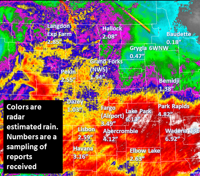
For a complete listing of rainfall reports, click here.
Storm Reports
..TIME...   ...EVENT...      ...CITY LOCATION...     ...LAT.LON...
..DATE...   ....MAG....      ..COUNTY LOCATION..ST.. ...SOURCE....
            ..REMARKS..

0509 PM     FLASH FLOOD      4 NNE PELICAN RAPIDS    46.62N 96.05W
07/11/2016                   OTTER TAIL         MN   PUBLIC

            DITCHES AND FIELDS FLOODING ALONG HWY 59 BETWEEN PELICAN
            RAPIDS AND DUNVILLA. REPORT POSTED VIA SOCIAL MEDIA.

0606 PM     FLASH FLOOD      DETROIT LAKES           46.81N 95.84W
07/11/2016                   BECKER             MN   PUBLIC

            FLOODING REPORTED IN WASHINGTON PARK AND STREET FLOODING
            ON LANGFORD STREET. REPORT AND PICTURES POSTED VIA SOCIAL
            MEDIA.

0625 PM     FLASH FLOOD      5 NE BARNESVILLE        46.70N 96.34W
07/11/2016                   CLAY               MN   TRAINED SPOTTER

            FIELDS AND FARM ACCESS ROADS FLOODED NEAR STONEY CREEK
            AND ACROSS NORTHERN HUMBOLDT AND SOUTHERN SKREE
            TOWNSHIPS.

0700 PM     FLASH FLOOD      5 S CHRISTINE           46.50N 96.81W
07/11/2016                   RICHLAND           ND   TRAINED SPOTTER

            FIELDS AND FARM ACCESS ROADS FLOODED ACROSS PORTIONS OF
            SOUTH EAGLE TOWNSHIP.

0754 PM     FLASH FLOOD      3 WNW DETROIT LAKES     46.83N 95.90W
07/11/2016                   BECKER             MN   BROADCAST MEDIA

            FLOODING REPORTED ON HIGHWAY 10. REPORT AND PHOTO POSTED
            VIA SOCIAL MEDIA.

0758 PM     FLASH FLOOD      1 S HEIGHT OF LAND LAKE 46.88N 95.61W
07/11/2016                   BECKER             MN   CO-OP OBSERVER

            FIELDS AND ACCESS ROADS FLOODED. OBSERVER REPORTS HAVING
            RECEIVED 3.6 INCHES OF RAIN SINCE 4 PM CDT. TOTAL OVER
            7.58 INCHES OF RAIN SINCE SATURDAY.

0855 PM     TSTM WND GST     1 SW LANGDON            48.75N 98.39W
07/11/2016  M59.00 MPH       CAVALIER           ND   AWOS

            PEAK WIND MEASURED AT THE LANGDON AIRPORT /KD55/.

0900 PM     FLASH FLOOD      4 WSW PARK RAPIDS       46.90N 95.14W
07/11/2016                   HUBBARD            MN   TRAINED SPOTTER

            FIELD FLOODING AND SOME BASEMENT FLOODING REPORTED ACROSS
            PORTIONS OF STRAIGHT RIVER TOWNSHIP.

0915 PM     TSTM WND DMG     3 N WALHALLA            48.96N 97.92W
07/11/2016                   PEMBINA            ND   TRAINED SPOTTER

            A FEW LARGE 3 TO 4 INCH DIAMETER TREE BRANCHES BROKEN
            DOWN...ALONG WITH SOME PEA SIZED HAIL.

0926 PM     FLASH FLOOD      2 W SEBEKA              46.63N 95.13W
07/11/2016                   WADENA             MN   TRAINED SPOTTER

            SOME FIELDS AND ACCESS ROADS IN RED EYE AND NORTHERN
            ROCKWOOD TOWNSHIPS ARE FLOODING. CAT AND KITTEN CREEKS
            ARE RUNNING BANKFUL NOW AND RISING... AS IS THE RED EYE
            RIVER.


 Follow us on YouTube