
Very difficult travel conditions from accumulating snow and ice, blowing snow, and very strong winds. Read More >
Overview
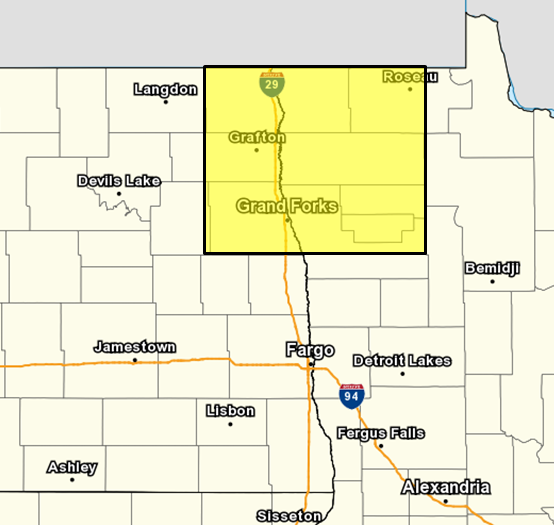
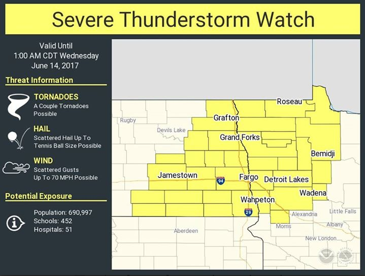
Several rounds of severe weather affected eastern North Dakota and the northwest quarter of Minnesota on June 13, 2017. Severe thunderstorms moved along the North Dakota/South Dakota border before sunrise, affecting portions of southeast North Dakota. Then strong winds developed in what is known as a "Wake Low," over the central and northern Red River Valley into portions of northwest Minnesota during the late morning and early afternoon. This produced very strong wind gusts in the Grand Forks/East Grand Forks area, which resulted in tremendous damage to trees, fences, signs, light poles, etc. Finally, in the late afternoon and evening, another round of severe thunderstorms fired up, mainly affecting southeast North Dakota into west central Minnesota. These storms started out producing large hail and a few funnel clouds, then transitioned to bow echoes and 60 to 70 mph winds. These strong winds hit the Fargo-Moorhead area as well as the Fergus Falls, Minnesota area.Watches & Warnings:
Here is a break up of the warnings and watches issued on June 13th.
 |
 |
||
| Early Morning Warnings | Mid-day High Wind Warning | Evening Severe Storm Watch | Afternoon/Evening Warnings |
Photos:
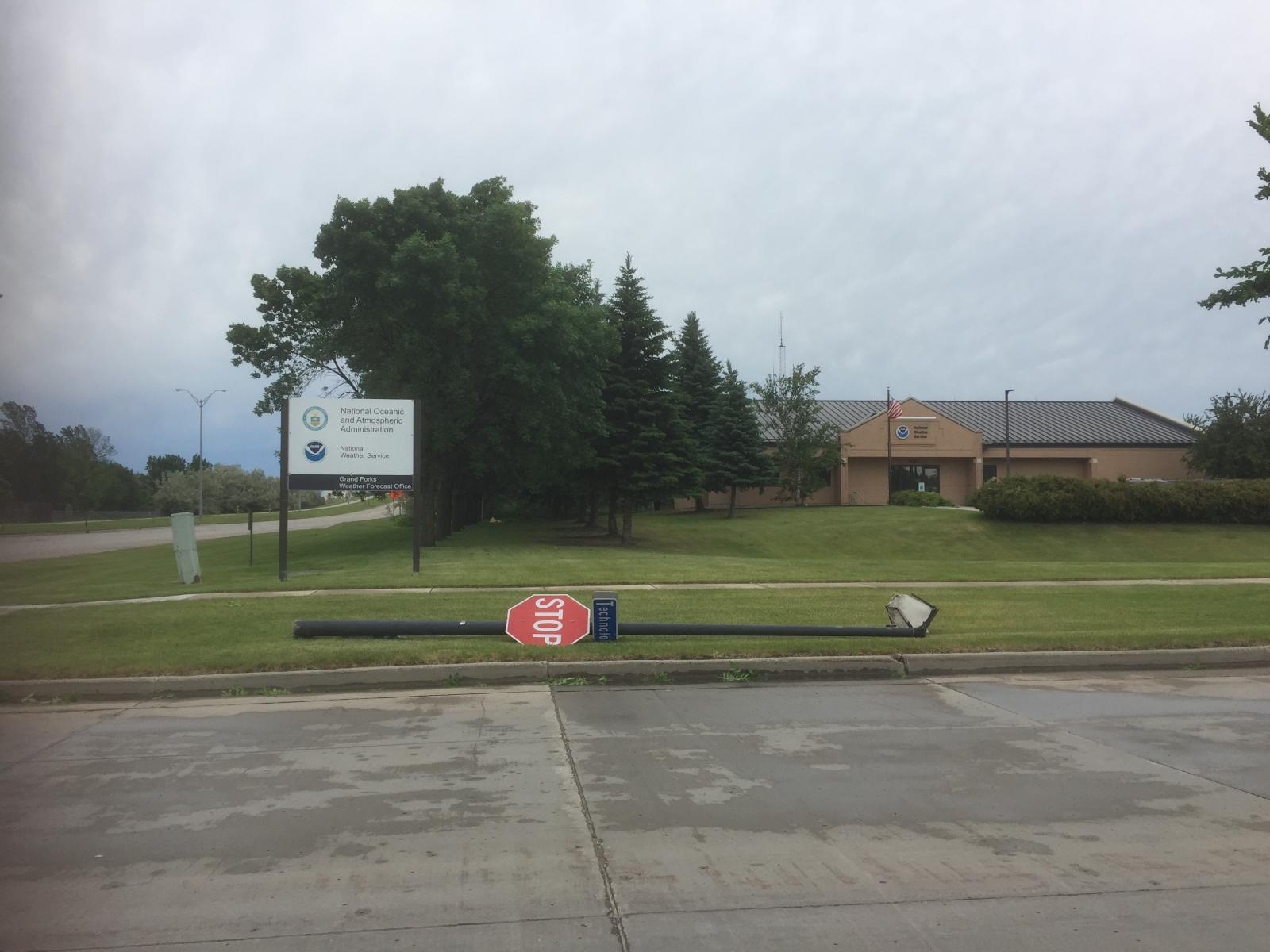
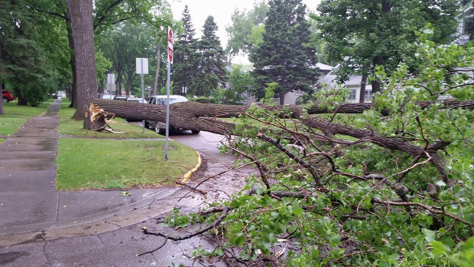
Damage Pictures from Grand Forks during the morning High Wind Warning
 |
 |
 |
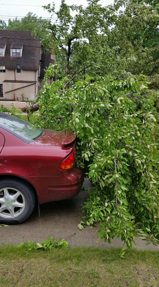 |
| Damage near NWS Grand Forks |
Damage on Hamline St near UND | Damage on Hamline St near UND | Damage on Hamline St near UND |
Radar:
| Morning Storms | Afternoon/Evening Storms |
Storm Reports
PRELIMINARY LOCAL STORM REPORT...SUMMARY
NATIONAL WEATHER SERVICE EASTERN ND/GRAND FORKS ND
1254 AM CDT WED JUN 14 2017

..TIME...   ...EVENT...      ...CITY LOCATION...     ...LAT.LON...
..DATE...   ....MAG....      ..COUNTY LOCATION..ST.. ...SOURCE....
            ..REMARKS..

0335 PM     HAIL             5 NNW MAHKONCE          47.39N 95.66W
06/13/2017  E1.00 INCH       MAHNOMEN           MN   PUBLIC

            VERY HEAVY RAIN AND DIME TO QUARTER SIZED HAIL.

0345 PM     HAIL             4 S LENGBY              47.46N 95.63W
06/13/2017  E1.25 INCH       MAHNOMEN           MN   PUBLIC

            A FEW NICKEL TO HALF DOLLAR HAIL IN VERY HEAVY RAIN.

0406 PM     HAIL             10 N BEMIDJI            47.63N 94.88W
06/13/2017  E1.00 INCH       BELTRAMI           MN   LAW ENFORCEMENT

            ALONG IRVINE AVE.

0705 PM     HAIL             1 NE NASHUA             46.05N 96.29W
06/13/2017  E1.00 INCH       WILKIN             MN   PUBLIC

            A FEW DIME TO QUARTER SIZED HAIL AND BRIEF HEAVY RAIN.

0725 PM     FUNNEL CLOUD     4 SSW HOFFMAN           45.78N 95.82W
06/13/2017                   GRANT              MN   FIRE DEPT/RESCUE

            FUNNEL MOVING UP FROM SOUTH.

0735 PM     HAIL             7 E KENT                46.44N 96.54W
06/13/2017  E1.00 INCH       WILKIN             MN   PUBLIC

            A FEW DIME TO QUARTER SIZED HAIL.

0735 PM     HAIL             1 S BRAMPTON            45.98N 97.78W
06/13/2017  E1.25 INCH       SARGENT            ND   TRAINED SPOTTER

            HAIL AND HEAVY RAIN.

0742 PM     FUNNEL CLOUD     1 SW HAVANA             45.94N 97.63W
06/13/2017                   SARGENT            ND   TRAINED SPOTTER

            BREIF FUNNEL CLOUD OBSERVED HIGH IN THE CLOUD.

0815 PM     TSTM WND DMG     5 N GWINNER             46.30N 97.66W
06/13/2017                   RANSOM             ND   TRAINED SPOTTER

            A FEW LARGE 4-6 INCH DIAMTER TREE LIMBS BROKEN DOWN.

0830 PM     HAIL             1 N ENDERLIN            46.64N 97.60W
06/13/2017  E1.00 INCH       CASS               ND   TRAINED SPOTTER

0830 PM     TSTM WND DMG     10 SSE HANKINSON        45.94N 96.81W
06/13/2017                   RICHLAND           ND   TRAINED SPOTTER

            UNSPECIFIED DAMAGES AT THE DAKOTA MAGIC CASINO. TREES
            BLOWN DOWN IN THE AREA. TIME ESTIMATED BASED ON RADAR.

0835 PM     TSTM WND GST     4 N MCLEOD              46.45N 97.30W
06/13/2017  M59.00 MPH       RANSOM             ND   MESONET

            PEAK WINDS MEASURED AT THE SHEYENNE RAWS STATION, SNGN8.
            TIME ESTIMATED FROM RADAR.

0839 PM     TSTM WND GST     2 SSW BARRIE            46.54N 97.14W
06/13/2017  M55.00 MPH       RICHLAND           ND   MESONET

            PEAK WINDS MEASURED AT AN NDAWN STATION.

0840 PM     HAIL             2 E CAMPBELL            46.10N 96.36W
06/13/2017  E1.25 INCH       WILKIN             MN   PUBLIC

0849 PM     TSTM WND GST     3 SE CAMPBELL           46.07N 96.36W
06/13/2017  E57.00 MPH       WILKIN             MN   MESONET

            PEAK WINDS MEASURED AT AN NDAWN STATION.

0854 PM     TSTM WND DMG     WEST FARGO              46.87N 96.90W
06/13/2017                   CASS               ND   PUBLIC

            A FEW 3 TO 4 INCH BRANCHES BROKEN DOWN. REPORTED VIA
            SOCIAL MEDIA.

0855 PM     TSTM WND GST     3 ESE BRECKENRIDGE      46.25N 96.53W
06/13/2017  E70.00 MPH       WILKIN             MN   CO-OP OBSERVER

            ESTIMATED WIND GUSTS WITH LARGE 18 INCH DIAMETER TREES
            BLOWN DOWN. SMALL SHED BLOWN DOWN.

0900 PM     TSTM WND DMG     CHRISTINE               46.58N 96.81W
06/13/2017                   RICHLAND           ND   PUBLIC

            STOP SIGN BENT OVER. REPORTED VIA SOCIAL MEDIA.

0902 PM     TSTM WND GST     DORAN                   46.19N 96.49W
06/13/2017  E65.00 MPH       WILKIN             MN   PUBLIC

            REPORTED VIA SOCIAL MEDIA.

0904 PM     TSTM WND GST     4 SSW FARGO             46.82N 96.85W
06/13/2017  E70.00 MPH       CASS               ND   TRAINED SPOTTER

            VERY STRONG WINDS FOR A MINUTE OR MORE.

0907 PM     TSTM WND GST     3 NNW FARGO             46.92N 96.84W
06/13/2017  E64.00 MPH       CASS               ND   ASOS

            SEVERE WIND GUSTS FOR SEVERAL MINUTES.

0910 PM     TSTM WND GST     5 ESE MOORHEAD          46.84N 96.66W
06/13/2017  M64.00 MPH       CLAY               MN   MESONET

            PEAK WINDS MEASURED AT AN RWIS STATION.

0912 PM     TSTM WND DMG     ROTHSAY                 46.47N 96.29W
06/13/2017                   WILKIN             MN   BROADCAST MEDIA

            FOUR TRACTOR-TRAILER RIGS WERE BLOWN OVER ON I-94 NEAR
            ROTHSAY. ROTHSAY RWIS POWER OUTAGE OCCURRED AT ABOUT THIS
            TIME.

0913 PM     TSTM WND GST     6 W WAHPETON            46.27N 96.74W
06/13/2017  M58.00 MPH       RICHLAND           ND   MESONET

            PEAK WINDS MEASURED AT AN RWIS STATION.

0913 PM     TSTM WND GST     2 S HUNTER              47.16N 97.22W
06/13/2017  M65.00 MPH       CASS               ND   MESONET

            PEAK WINDS MEASURED AT A PERSONAL WEATHER STATION.

0914 PM     TSTM WND GST     2 S FERGUS FALLS        46.25N 96.07W
06/13/2017  M67.00 MPH       OTTER TAIL         MN   AWOS

            PEAK WINDS MEASURED AT THE FERGUS FALLS AIRPORT.

0915 PM     TSTM WND GST     FARGO                   46.88N 96.82W
06/13/2017  E70.00 MPH       CASS               ND   TRAINED SPOTTER

            PEAK WINDS ESTIMATED TO 70 MPH DOWNTOWN. SOME STREET
            FLOODING BGINNING.

0920 PM     TSTM WND DMG     FERGUS FALLS            46.28N 96.07W
06/13/2017                   OTTER TAIL         MN   TRAINED SPOTTER

            TREE LIMBS DOWN AROUND TOWN. SOME MINOR STREET FLOODING
            BEGINNING.

0928 PM     TSTM WND GST     1 N ARGUSVILLE          47.07N 96.94W
06/13/2017  E60.00 MPH       CASS               ND   TRAINED SPOTTER

0929 PM     TSTM WND GST     2 W URBANK              46.13N 95.55W
06/13/2017  M60.00 MPH       OTTER TAIL         MN   TRAINED SPOTTER

            SOME TREE LIMBS BROKEN DOWN.

0930 PM     TSTM WND DMG     ARGUSVILLE              47.05N 96.94W
06/13/2017                   CASS               ND   PUBLIC

            LARGE TREE BLOWN DOWN IN ARGUSVILLE.

0935 PM     TSTM WND GST     1 SW LAKE PARK          46.87N 96.11W
06/13/2017  M61.00 MPH       BECKER             MN   MESONET

            PEAK WINDS MEASURED AT AN RWIS STATION.

0955 PM     TSTM WND DMG     4 ESE DETROIT LAKES     46.79N 95.76W
06/13/2017                   BECKER             MN   TRAINED SPOTTER

            A LARGE TREE WAS DOWN ALONG THE HIGHWAY.
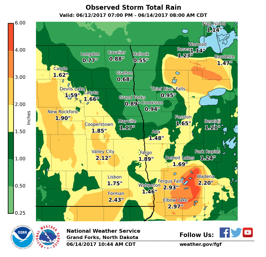
Rain Reports
Satellite
| Infrared Imagery |
Surface Maps
| Surface Maps from June 13th |
 |
Media use of NWS Web News Stories is encouraged! Please acknowledge the NWS as the source of any news information accessed from this site. |
|

