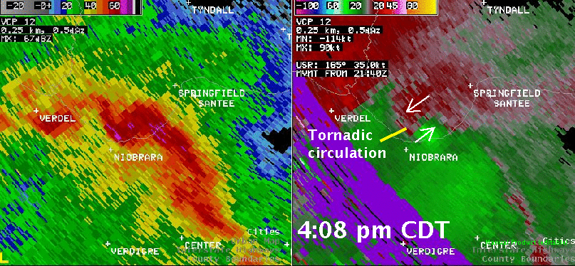
On March 23, 2009 a line of severe thunderstorms moved from eastern Nebraska into southeastern South Dakota and northwestern Iowa. One tornado was confirmed with this line of storms. It was an EF1 tornado 5 miles southwest of Springfield, South Dakota. The radar picture below, taken at 4:08 pm CDT, shows the circulation associated with the tornado as it crossed the Missouri River southwest of Springfield.
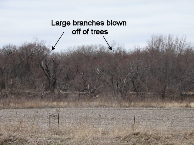
Wind damage was also reported from Akron, Iowa to Hawarden, Iowa. A storm survey done showed that winds of 80 to 100 mph occurred as the squall line moved to the north. Evidence of wind damage is seen near the intersection of Highway 12 and 104th Street near Akron, Iowa. The pictures below show several trees which lost branches along the east side of Highway 12.
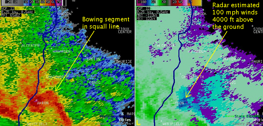
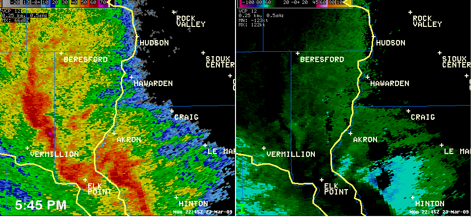
At this time, the radar imagery showed a bowing segment in the squall line near Akron. In addition, the radar estimated wind speeds around 100 mph at 4000 feet above the ground.
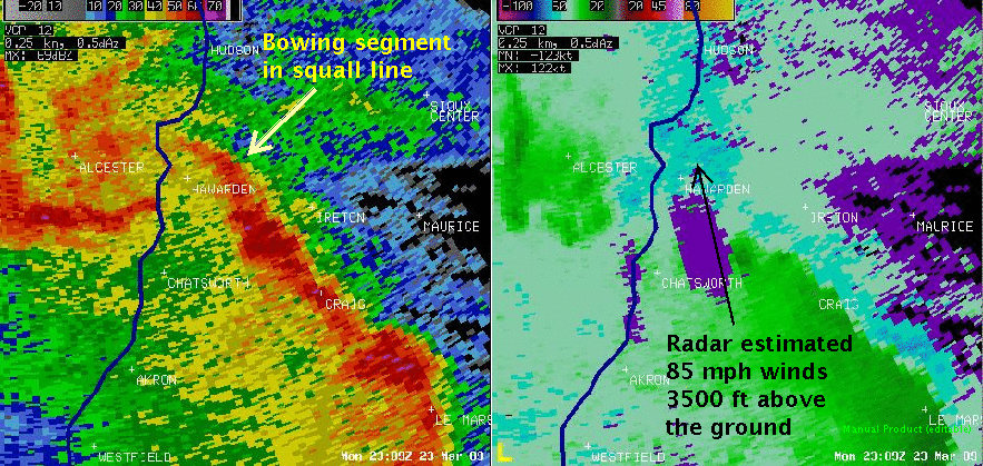
The squall line surged north producing damage around Chatsworth. By 609 pm CDT, the damaging winds had reach the Hawarden area. The radar showed wind speeds estimated around 85 mph near Hawarden.
Numerous trees and buildings were damaged in Hawarden. Below are pictures of damage taken by the Hawarden Civil Defense Directory, Jeff Nohava and also be the National Weather Service.
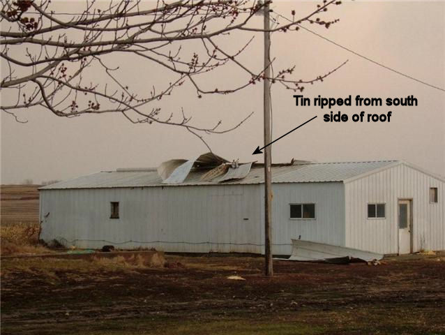
Photo by Jeff Nohava.
Tin from this shed was stripped from the south side of the roof and folded over to the north side of the roof. A couple of strips of tin were completely torn from the roof and one piece of tin was lodged into the trees to the north as shown in the photo below.
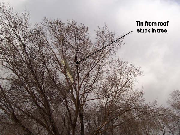
Photo by Jeff Nohava.
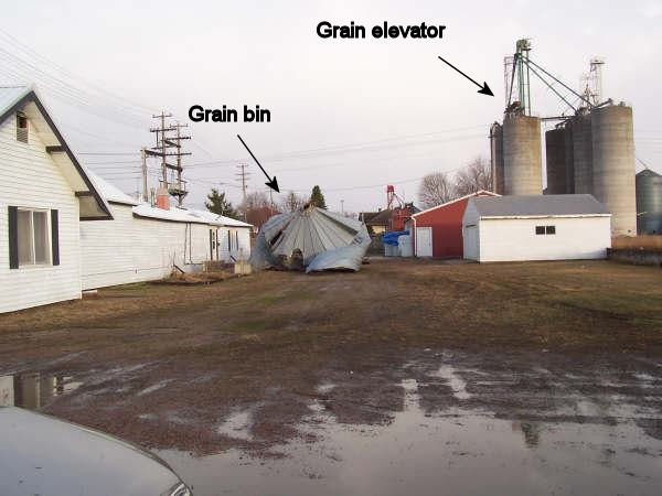
Photo by Jeff Nohava
A grain bin was blown from a grain elevator to the south. It hit the red shed on the south side and then was carried over the shed and landed in the alley on the other side of the shed.
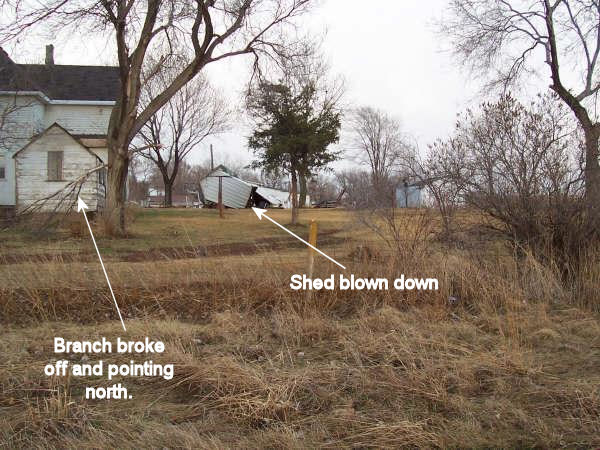
Photo by Jeff Nohava
This photo shows evidence of straight-line winds. In the foreground a small branch was snapped and is now pointing to the north. In the background, a shed was blown over to the north. This suggests that damaging winds from the south.

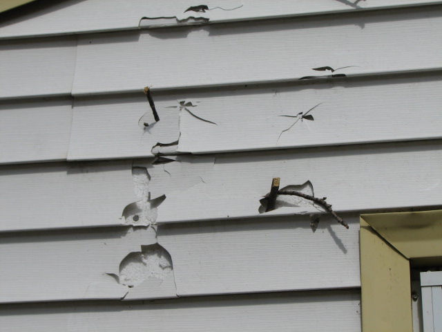
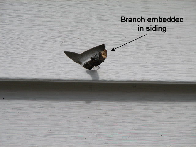
As seen in the picture above, several large branches were broke off of this tree. In addition to these large branches, numerous small branches were also torn from the tree. In the pictures below, one can see several of these small branches were embedded in the siding of a house which was located to the north of the tree. The impact of the branches was so strong that it broke through the vinyl siding and become embedded in the insulation behind the siding.
Here is a radar loop of the reflectivity and velocity data near Akron and Hawarden, Iowa. The loop is from 5:45 pm - 6:18 pm CDT.
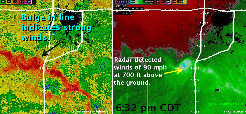
There were also numerous reports of damaging winds from 60 to 80 mph. The strongest wind report was 81 mph at the airport in Spencer, Iowa. In addition, 70 mph winds were reported near Sioux Falls, South Dakota. The strong winds were observed by the radar as they moved across northern Lincoln County, South Dakota toward Sioux Falls. The radar picture below shows radar detected wind speeds of 90 mph approaching the southwest side of Sioux Falls. There was a bulge in the line of thunderstorms where the winds were strongest.
Winds around 70 mph were also reported south of Freeman, South Dakota. These winds resulted in some damage to trees and buildings across the area as well as two reports of trucks overturned by the winds.
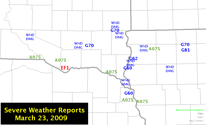
Below is a map summarizing the severe weather reports around the area.
PRELIMINARY LOCAL STORM REPORT...SUMMARY
NATIONAL WEATHER SERVICE SIOUX FALLS SD
249 PM CDT TUE MAR 24 2009
..TIME... ...EVENT... ...CITY LOCATION... ...LAT.LON...
..DATE... ....MAG.... ..COUNTY LOCATION..ST.. ...SOURCE....
..REMARKS..
0400 PM HAIL 4 ESE FAIRFAX 43.01N 98.81W
03/23/2009 E0.75 INCH GREGORY SD PUBLIC
50 MPH WINDS
0415 PM TORNADO 5 SW SPRINGFIELD 42.81N 97.97W
03/23/2009 BON HOMME SD PUBLIC
EF1 DAMAGE TO MACHINE SHED.
0427 PM HAIL 1 W AVON 43.01N 98.08W
03/23/2009 M0.75 INCH BON HOMME SD LAW ENFORCEMENT
0430 PM TSTM WND DMG PLATTE 43.39N 98.84W
03/23/2009 CHARLES MIX SD LAW ENFORCEMENT
NUMEROUS TREE LIMBS AND BRANCHES DOWN.
0510 PM TSTM WND DMG OLIVET 43.24N 97.67W
03/23/2009 HUTCHINSON SD LAW ENFORCEMENT
TREE BRANCHES DOWN.
0522 PM TSTM WND GST 2 S JACKSON 42.42N 96.57W
03/23/2009 E60.00 MPH DAKOTA NE EMERGENCY MNGR
TREE BLOWN DOWN
0522 PM HAIL 5 S HUBBARD 42.32N 96.59W
03/23/2009 M0.75 INCH DAKOTA NE LAW ENFORCEMENT
DEPUTIES REPORTED DIME SIZE HAIL BETWEEN HUBBARD,
EMERSON, AND HOMER NEBRASKA.
0527 PM TSTM WND GST 8 S FREEMAN 43.24N 97.42W
03/23/2009 E70.00 MPH HUTCHINSON SD BROADCAST MEDIA
LARGE TREE BRANCHES BLOWN DOWN
0538 PM HAIL VERMILLION 42.78N 96.93W
03/23/2009 M0.75 INCH CLAY SD PUBLIC
LOCALIZED STREET FLOODING.
0538 PM TSTM WND DMG 1 NW JEFFERSON 42.62N 96.58W
03/23/2009 UNION SD EMERGENCY MNGR
SEMI TRUCK OVERTURNED AT WEIGH STATION.
0600 PM TSTM WND DMG CHATSWORTH 42.92N 96.51W
03/23/2009 SIOUX IA TRAINED SPOTTER
TREES BLOWN DOWN...CAMPER TURNED OVER...SHINGLES STRIPPED
OFF ROOF
0600 PM TSTM WND GST 1 NE AKRON 42.84N 96.54W
03/23/2009 E60.00 MPH PLYMOUTH IA PUBLIC
DAMAGE TO HOUSE...OUTBUILDINGS...GARAGE AND TREE LIMBS OF
VARIOUS SIZES SNAPPED OFF
0608 PM HAIL SALIX 42.31N 96.29W
03/23/2009 M0.75 INCH WOODBURY IA TRAINED SPOTTER
0612 PM HAIL 2 W SALIX 42.31N 96.33W
03/23/2009 M0.75 INCH WOODBURY IA TRAINED SPOTTER
THUNDERSTORM WIND GUSTS TO 60 MPH.
0619 PM TSTM WND GST HAWARDEN 43.00N 96.48W
03/23/2009 M62.00 MPH SIOUX IA COUNTY OFFICIAL
TREE BRANCHES BLOWN DOWN DAMAGE TO ROOF OF HOUSE
0630 PM TSTM WND DMG HULL 43.19N 96.13W
03/23/2009 SIOUX IA TRAINED SPOTTER
METAL BUILDING ROOF BLOWN ONTO HIGHWAY 18.
0630 PM TSTM WND DMG 1 NNE TEA 43.46N 96.83W
03/23/2009 LINCOLN SD AMATEUR RADIO
5 INCH TREE LIMBS DOWN.
0633 PM TSTM WND GST 3 N TEA 43.50N 96.83W
03/23/2009 E70.00 MPH LINCOLN SD EMERGENCY MNGR
THUNDERSTORMS WINDS UP TO 70 MPH AT 57TH AND TEA ELLIS
ROAD. SOME DEBRIS WAS OBSERVED.
0646 PM TSTM WND DMG 3 SW SIOUX FALLS 43.51N 96.77W
03/23/2009 MINNEHAHA SD EMERGENCY MNGR
STREET LIGHT BLOWN OUT IN SW SIOUX FALLS.
0707 PM HAIL 4 W SHELDON 43.18N 95.92W
03/23/2009 M0.75 INCH SIOUX IA TRAINED SPOTTER
0755 PM TSTM WND DMG 3 N CHEROKEE 42.79N 95.55W
03/23/2009 CHEROKEE IA LAW ENFORCEMENT
STRONG THUNDERSTORM WINDS BLEW A SEMI TRUCK OVER 3 MILES
NORTH OF CHEROKEE IOWA.
0842 PM TSTM WND GST 3 WNW SPENCER 43.17N 95.20W
03/23/2009 M81.00 MPH CLAY IA OFFICIAL NWS OBS
0851 PM TSTM WND GST 4 NW SPENCER 43.19N 95.21W
03/23/2009 E70.00 MPH CLAY IA TRAINED SPOTTER


 Weather Story
 Weather Map
 Local Radar
 Follow us on YouTube