
Severe thunderstorms, excessive rainfall, critical fire weather are all in the outlook today and into this last weekend of April. Very large hail, severe wind gusts, and a couple strong tornadoes will all be possible across the central and southern Plains today. Flash flooding also possible for portions of the Plains and Mississippi Valley. Critical fire weather conditions for Southern High Plains Read More >
On July 1st, a high precipitation supercell caused widespread wind damage from near Wentworth South Dakota through Marshall Minnesota. In addition to widespread wind damage of 80-110 mph, two brief tornadoes developed near Tyler and Ruthton MN.
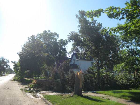
Tyler Tornado
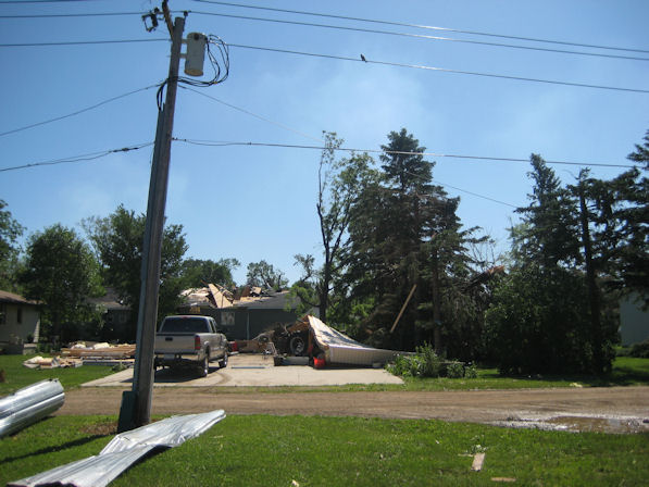
A tornado touched down on the southwest side of Tyler Minnesota around 3:57 pm cdt, and tracked northeast across town. In addition to demolishing several outbuildings and storage facilities, numerous structures experienced total roof loss and damage to the exterior siding. The most significant damage was noted in a path from near the intersection of County Road 8 and Highway 14, northeast towards Maple and Lincoln Streets. This is where the tornado was rated a low end EF2 with estimated winds of 115 mph. The tornado was at its widest in this area, where it was approximately one quarter mile wide. The tornado had a path length of approximately three miles. Widespread tree damage and tree-top debarking was also discovered.
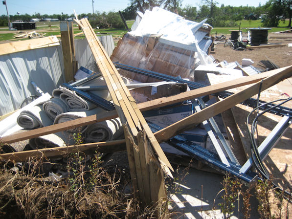
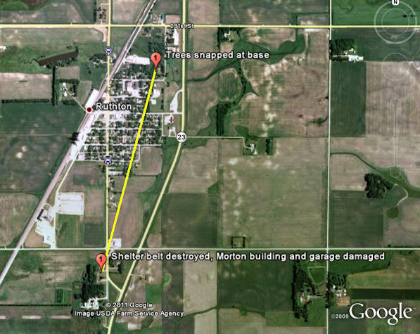
Below are images of a Morton building that was destroyed by a tornado on the southwest side of Tyler, MN. Trees were also snapped off at the base at this location.

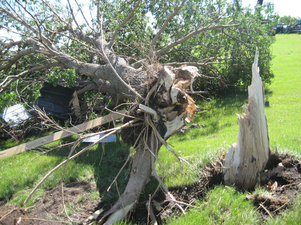
Below is an image of tree and house damage on the southwest side of Tyler, Minnesota.

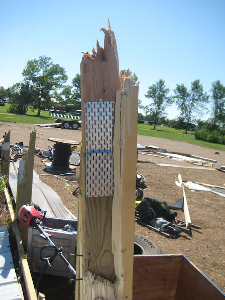
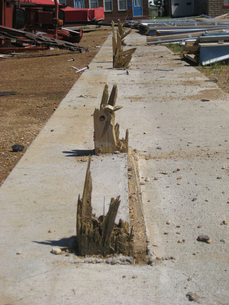
Below are images near downtown Tyler, Minnesota where an EF2 tornado caused widespread damage. A Morton building was destroyed downtown when the garage doors failed in the strong winds. The tornado caused the support beams to fail in rapid succession.

Ruthton Tornado
A second tornado touched down in Pipestone County around 3:50 PM CDT just southwest of the town of Ruthton. This tornado tracked northeast across the town of Ruthton toward the intersection of northwestern Murray and southern Lyon counties. The most significant damaged occurred on the south side of Ruthon just west of Highway 23 where several garages were damaged and one was completely cleared off the foundation. The tornado was rated a high end EF1 with estimated winds of 100-110 mph. The tornado was approximately one eighth of a mile wide and had a path length of approximately one mile.
Below are images from the Ruthton, Minnesota tornado. The first image was taken on the southern edge of Ruthton was a farmstead was damaged. The second image was taken on the north side of Ruthton near the cemetery where large trees were snapped.


In addition to the two tornadoes, widespread wind damage of 80-100 mph caused significant damage between Wentworth, SD to Marshall, MN.
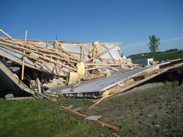
Below are images of a Morton building destroyed northwest of Egan, SD.

Below are images of trees snapped and uprooted near downtown Flandreau, SD.

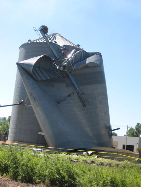
Below is an image of grain bins damaged 4 miles north of Verdi, MN.

Below is an image of trees uprooted east of Ruthton, MN near the Ruthton State Wildlife Management Area.

...DAMAGE ASSESSMENT RESULTS FROM PIPESTONE AND LINCOLN COUNTIES IN
MINNESOTA...
A SUPERCELL THUNDERSTORM MOVED ACROSS SOUTHWESTERN MINNESOTA ON THE
AFTERNOON OF JULY 1. IN ADDITION TO WIDESPREAD THUNDERSTORM WIND
DAMAGE ACROSS SEVERAL COUNTIES...BRIEF TORNADO TOUCHDOWNS OCCURRED.
ONE TORNADO TOUCHED DOWN ON THE SOUTHWESTERN SIDE OF TYLER MINNESOTA
AROUND 3:57 PM CDT...AND TRACKED NORTHEAST ACROSS THE TOWN. IN
ADDITION TO DEMOLISHING SEVERAL OUTBUILDINGS AND STORAGE
FACILITIES...NUMEROUS STRUCTURES EXPERIENCED TOTAL ROOF LOSS AND
DAMAGE TO EXTERIOR SIDING. THE MOST SIGNIFICANT DAMAGE WAS NOTED IN
A PATH FROM NEAR THE INTERSECTION OF COUNTY ROAD 8 AND HIGHWAY
14...NORTHEAST TOWARD MAPLE AND LINCOLN STREETS...WHERE THE TORNADO
WAS RATED A LOW-END EF2 WITH ESTIMATED WINDS AROUND 115 MPH. THE
TORNADO WAS AT ITS WIDEST IN THIS AREA...WHERE IT WAS APPROXIMATELY
ONE QUARTER MILE WIDE. THE TORNADO HAD A PATH LENGTH OF
APPROXIMATELY 3 MILES. WIDESPREAD TREE DAMAGE AND TREE-TOP DEBARKING
WAS ALSO DISCOVERED.
ANOTHER TORNADO TOUCHED DOWN IN PIPESTONE COUNTY AROUND 3:50 PM CDT
JUST SOUTHWEST OF THE TOWN OF RUTHTON. THIS TORNADO TRACKED
NORTHEAST ACROSS THE TOWN OF RUTHTON TOWARD THE INTERSECTION OF
NORTHWESTERN MURRAY AND SOUTHERN LYON COUNTIES. THE MOST SIGNIFICANT
DAMAGE OCCURRED ON THE SOUTH SIDE OF RUTHTON JUST WEST OF HIGHWAY
23...WHERE SEVERAL GARAGES WERE DAMAGED...AND ONE WAS
COMPLETELY CLEARED OFF THE FOUNDATION. THE TORNADO WAS RATED A HIGH
END EF1...WITH ESTIMATED WINDS OF 100-110 MPH. THE TORNADO WAS
APPROXIMATELY ONE EIGHTH OF A MILE WIDE...AND HAD A PATH LENGTH OF
APPROXIMATELY 4 MILES.
ADDITIONAL INFORMATION ABOUT THESE TORNADOES AND THE EXTENSIVE WIND
DAMAGE...INCLUDING PICTURES...WILL BE POSTED TO OUR WEB SITE AT
WEATHER.GOV/SIOUXFALLS EARLY NEXT WEEK.


 Weather Story
 Weather Map
 Local Radar
 Follow us on YouTube