The U.S. Geological Survey has installed new equipment at the river gauge on the Big Sioux River that will be providing near real-time river stage data. This location has been a long time river forecast point for the National Weather Service, using readings taken at most a few times a day during flood situations from a manual river gauge. The new equipment and real-time data will allow the NWS to more closely monitor river levels year-around and provide flood forecasts and warnings during any potential high water events.
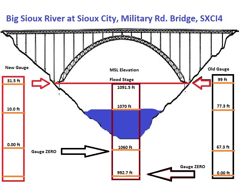
One big change that is coming with this new USGS gauge is that the MSL elevation that is referenced as 0.00 ft (zero datum) on the river data will be changing. The old zero datum was 992.7 ft MSL, and the new zero datum is 1060.0 ft MSL. This will result in a change in reported river levels of about 67 ft. Flood stage will now be 31.5 ft on the new gauge, where it was 99 ft at the old gauge. There is NO change to the MSL elevation of flood stage or any of the impacts, only a change in what is being reported as the river stage, flood stage, and impact levels between the old and new gauge. The image below attempts to illustrate these changes.
More information and current/forecast conditions for this river gauge can be found from the NWS at:
https://water.weather.gov/ahps2/hydrograph.php?wfo=fsd&gage=sxci4
or from the USGS at:


 Weather Story
 Weather Map
 Local Radar
 Follow us on YouTube