The total precipitation at Sioux Falls Airport in the year 2000 was 26.11 inches, which was 2.25 inches above normal. There were the usual variations in precipitation over the area...mainly due to the localized nature of summertime thunderstorms...with up to 30 inches precipitation recorded in parts of the area for the year. The temperature for the year averaged out to exactly the normal of 45.5 degrees.
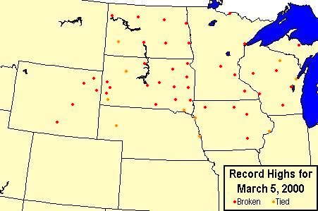 The beginning of the year through March 2000 continued the rather dry and warm pattern that started in August 1999. The meteorological winter of December 1999 through February 2000 was the 8th warmest since records began in 1893...with February 2000 the 5th warmest February on record.
Only 21.4 inches snowfall occurred for the season... helped quite a bit by the welcome wet snow of 5.3 inches at the airport on April 7th...with over a foot of snowfall just north of Sioux Falls. Until this storm...dry...warm...and rather windy weather was a problem helping cause grass fires to flare up again in the area. The strongest wind of the year at the airport occurred on April 5th with northwest winds gusting up to 62 mph. The April 7th snowstorm started a trend towards cooler and wetter weather. Freezing rain fell on April 16th with significant precipitation up to an inch in the area...and the total April precipitation was near normal.
May 2000 was stormy and wet...totaling 5.56 inches for the month...compared to a normal of 3.03 inches for may. Early season thunderstorm complexes affected the area on May 7th...11th...and 15th. A severe thunderstorm barreled through western and southern Sioux Falls the late evening of May 15th dumping hail up to golf ball size and leaving melting drifts of hail into the next afternoon. The large hail broke some windows in homes and damaged vehicles in Sioux Falls and damaged emerging crops in the area. The storm caused extensive damage on a new car lot in Worthing at 11 pm that evening. The heaviest rain event of the year occurred from May 17th to 18th...with 2.51 inches registered at the airport.
The summer was overall on the cool side compared to normal...with near normal precipitation. There were several hot days...with a record breaking 97 on June 8th and 99 on August 30th being the warmest temperatures at Sioux Falls since the summer of 1995. Big time summer thunderstorms affected the Sioux Falls area June 24th...on July 9th and 11th...and August 4th to the 7th. Shortly after midnight on June 24th...thunderstorms developed rapidly right over the city of Sioux Falls and moved southeast...dumping up to 3 inches of rain. The storm dropped hail up to golf ball size in a strip from southern Sioux Falls to Canton...causing widespread crop damage in Lincoln County. On July 9th, a couple of thunderstorms brought a total of 1.37 inches rain and a wind gust to 55 mph at the airport at 842 pm. In the late afternoon of July 11th, a severe thunderstorm complex developed northwest of Sioux Falls and moved southeast. Sioux Falls itself was spared compared to the large hail and wind damage north...west...and southwest of the city. An F2 tornado from this storm caused damage at the Lake County Speedway at 6 pm. Around 4 am on August 5th the same thunderstorm system that hit Mitchell with a severe thunderstorm and 120 mph winds 2 hours before...brought 1.73 inches of rain to Sioux Falls but fortunately not the high winds.
September through October was overall rather quiet and mild. However...an unseasonably cold polar high pressure system moved slowly southeast over the area October 6th through the 10th bringing an abrupt end to the growing season. The lowest temperature of the month of 15 degrees occurred on the 8th and was a record low for the date. There was also a record high pressure for October of 30.78 inches on the 8th.
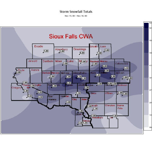
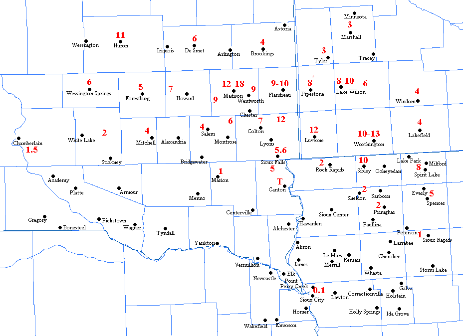
But the real return to winter weather started in early November and continued through the end of the year...with similarities to the last cold winter in 1996-97. Four decent snowfalls on November 7th...11-12th...15th...and 30th brought a total of 19.6 inches snowfall in November for the 2nd snowiest November on record. It was also the 6th coldest November followed by the 2nd coldest December. The most significant 24 hour snowfalls during this period at the airport were 5.7 inches November 11-12th...5.3 inches from November 15-16th...and 5.1 inches December 10-11th. A blizzard hit the area on December 16th bringing northwest winds gusting to 52 mph and wind chills down to 60 below zero. Several other less strong blizzards and wind chill events occasionally affected the area the rest of the month.
THE FOLLOWING TABLES GIVE A MONTH BY MONTH BREAKDOWN OF WEATHER IN 2000 AT THE SIOUX FALLS AIRPORT...
AVERAGE             DEPARTURE  EXTREMES    MONTHLY
 MONTH          MAX   MIN   MONTHLY  FROM NORM  HIGH LOW    RECORDS

JANUARY        29.1   5.6     17.4    PLUS 3.6   48  10B
FEBRUARY       41.2  19.6     30.4   PLUS 10.5   66   1    5TH WARMEST
MARCH          52.8  25.9     39.4    PLUS 6.9   80   7
APRIL          58.3  33.6     46.0   MINUS 0.9   79  17
MAY            71.6  46.7     59.2    PLUS 0.8   86  32
JUNE           77.4  54.0     65.7   MINUS 2.6   97  40
JULY           82.3  61.1     71.7   MINUS 2.6   93  46
AUGUST         82.8  60.4     71.6    PLUS 0.2   99  48
SEPTEMBER      75.6  47.1     61.4    PLUS 0.5   92  28
OCTOBER        61.8  40.4     51.1    PLUS 2.5   83  15
NOVEMBER       32.9  17.0     25.0   MINUS 8.0   69   3B   2ND SNOWIEST
DECEMBER       16.4  B1.2      7.6  MINUS 10.7   38  19B   2ND COLDEST

 2000          56.9  34.2     45.5           0   99  19B

NORMAL YEAR    56.8  34.2     45.5
DEPARTURE             DEPARTURE    MAX WIND GUSTS...
   MONTH           FROM NORM   SNOWFALL  FROM NORM   DIRECTION/MPH/DATE

JANUARY     .68    PLUS  .17      6.0    MINUS 0.7      NW 52 ON 10TH
FEBRUARY   1.04    PLUS  .37      1.2    MINUS 6.5       N 39 ON 3RD
MARCH       .91   MINUS  .73      2.7    MINUS 5.3       N 59 ON 28TH
APRIL      2.27   MINUS  .25      5.6     PLUS 3.4      NW 62 ON 5TH
MAY        5.56    PLUS 2.53       0                    NW 48 ON 22ND
JUNE       3.26   MINUS  .14       0                     S 44 ON 9TH
JULY       3.22    PLUS  .54       0                     N 55 ON 9TH
AUGUST     3.17    PLUS  .32       0                     S 40 ON 7TH
SEPTEMBER  1.34   MINUS 1.68       0                    NW 38 ON 20TH
OCTOBER    1.79    PLUS  .01       0     MINUS 0.6       S 40 ON 31ST
NOVEMBER   2.52    PLUS 1.43     19.6    PLUS 14.5       W 44 ON 2ND
DECEMBER    .35   MINUS  .35     11.4     PLUS 3.6      NW 52 ON 16TH

 2000     26.11    PLUS 2.25     46.5     PLUS 8.4      NW 62 APR 5TH

NOTE: IN FEB ALSO NW 39 MPH ON 26TH
      IN JUN ALSO NW 44 MPH ON 20TH
      IN DEC ALSO NW 52 MPH ON 20TH


RICHARD S. RYRHOLM/ CLIMATIC FOCAL POINT


 Weather Story
 Weather Map
 Local Radar
 Follow us on YouTube