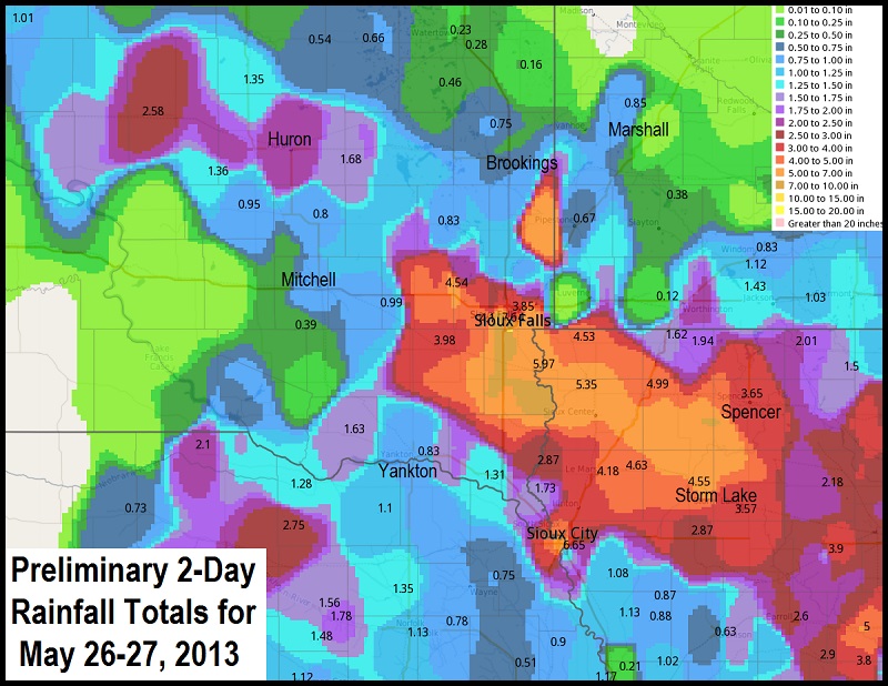
NOTE: Due to interpolation/smoothing or potentially bad data points, the above map may not reflect the exact rainfall total at your location. The data included here are PRELIMINARY. Observations are collected from a variety of sources with varying equipment and exposures. Not all data listed is considered official. The National Weather Service thanks its private and public partners for providing us with this data.
| SOUTH DAKOTA | |
| Sioux Falls 4.1 WSW |
8.11 |
|
Sioux Falls 3.7 SW |
7.64 |
|
Sioux Falls 5.7 SW |
7.46 |
|
Harrisburg 2.5 NW |
7.12 |
|
Sioux Falls 4.5 SSW |
6.72 |
|
Sioux Falls 4.1 SSE |
6.45 |
|
Canton |
5.97 |
|
Sioux Falls Skunk Creek |
5.81 |
|
Beresford 0.2 E |
5.70 |
|
Sioux Falls 3.4 ESE |
5.29 |
|
Sioux Falls 3.4 ESE |
5.08 |
|
Sioux Falls 2.6 ESE |
4.81 |
|
Hartford 0.5 N |
4.41 |
|
Hartford 2 ENE |
4.17 |
|
Centerville |
4.10 |
|
Wall Lake |
4.10 |
|
Sioux Falls Airport |
4.10 |
|
Marion 0.5 NE |
3.99 |
|
Sioux Falls North Cliff |
3.90 |
|
Parker |
3.42 |
|
Holstein |
2.87 |
|
Hurley 0.2 S |
2.79 |
|
Renner 4.1 NW |
2.45 |
|
James River near Huron |
2.32 |
|
Huron Airport |
2.16 |
|
Sioux Falls 60th Street North |
2.00 |
|
Colton 7 WNW |
1.97 |
|
Howard 5.3 W |
1.95 |
|
Forestburg |
1.49 |
|
Tabor 3.8 SSE |
1.35 |
|
Brookings 6.8 SSW |
1.24 |
|
Garretson 6.9 W |
1.18 |
|
Howard 10.3 NNE |
1.16 |
|
Fulton 9.4 N |
1.15 |
|
Vermillion |
1.14 |
|
Dell Rapids 0.9 WNW |
1.05 |
|
Yankton Airport |
1.02 |
|
Chester |
1.00 |
|
Chester 5 ESE |
1.00 |
|
Wessington Springs |
0.95 |
|
Vermillion River near Parker |
0.91 |
|
Bruce 4.1 NE |
0.90 |
|
Madison |
0.83 |
|
Yankton |
0.83 |
|
Scotland |
0.81 |
|
Big Sioux River Near Bruce |
0.75 |
|
Nunda 1.3 WSW |
0.74 |
|
Dell Rapids |
0.69 |
|
Mitchell 5.3 WSW |
0.60 |
|
Brookings |
0.58 |
|
Aurora 7 SSW |
0.58 |
|
Mitchell 1.1 N |
0.56 |
|
Brookings 1.1 S |
0.45 |
|
Brookings 1.7 SW |
0.44 |
|
Astoria 2.2 SSE |
0.43 |
|
Brookings 0.2 SSW |
0.42 |
|
White 0.1 S |
0.36 |
|
Springfield |
0.33 |
|
Bonesteel 0.1 S |
0.32 |
|
Aurora 7.5 N |
0.27 |
|
Corsica 2.8 SSW |
0.23 |
|
Mount Vernon |
0.13 |
|
Menno |
0.07 |
|
Platte 1.5 E |
0.05 |
|
Platte 13.7 W |
0.03 |
|
Herrick 8.2 SSW |
0.03 |
|
Chamberlain Airport |
0.01 |
|
Platte |
0.01 |
|
|
|
|
MINNESOTA |
|
|
Jackson |
2.16 |
|
Hardwick |
1.60 |
|
Lakefield |
1.43 |
|
Heron Lake |
1.12 |
|
Luverne Airport |
0.91 |
|
Jackson Airport |
0.90 |
|
Pipestone |
0.68 |
|
Pipestone |
0.62 |
|
Windom Airport |
0.53 |
|
Pipestone Airport |
0.40 |
|
Lamberton |
0.18 |
|
Marshall 0.6 S |
0.17 |
|
Russell |
0.13 |
|
Marshall Airport |
0.03 |
|
|
|
|
IOWA |
|
|
Sioux Center 2 SE |
8.10 |
|
Alton |
7.00 |
|
Orange City |
6.65 |
|
Rock Valley |
5.36 |
|
Hawarden |
5.68 |
|
Cherokee |
5.13 |
|
Sheldon Airport |
4.99 |
|
Linn Grove |
4.82 |
|
Everly 0.3 WSW |
4.28 |
|
Le Mars Airport |
4.18 |
|
Ocheyedan River / Spencer |
3.90 |
|
Spencer Airport |
3.65 |
|
Storm Lake Airport |
3.57 |
|
Big Sioux River near Akron |
2.60 |
|
Little Sioux / Correctionville |
2.34 |
|
Lake Park 3.2 SSE |
1.87 |
|
Westfield 4 SSE |
1.73 |
|
Sibley |
1.62 |
|
Perry Creek near Sioux City |
1.51 |
|
Sioux City ANG |
1.24 |
|
Sioux City Airport |
1.19 |
|
Holly Springs |
1.08 |
|
Shadehill Reservoir |
0.93 |
|
Rock Valley |
0.64 |
|
Hornick |
0.64 |
|
Mapleton |
0.30 |
|
|
|
|
NEBRASKA |
|
|
South Sioux City |
1.11 |
|
Hubbard 3.1 SW |
0.77 |


 Weather Story
 Weather Map
 Local Radar
 Follow us on YouTube