Radar remains the primary way used to issue tornado and severe thunderstorm warnings. Additional information from weather spotters and analysis of the atmosphere from satellite and computer models provide critical information for the decision to issue tornado and severe thunderstorm warnings. The tornado which touched down in northeastern Kingsbury County South Dakota had a very different evolution on radar than we see with large supercell tornadoes, such as the one that hit Manchester South Dakota on June 24, 2003. In the case of supercell tornadoes, meteorologists typically see strong rotation within the thunderstorm approximately 10 to 30 thousand feet above the ground. Gradually the strong circulation within the thunderstorms will build down toward the ground. This rotation is generally evident up to an hour before the tornado touches down.
In the case of the tornado on May 2, it was classified as a non-supercell tornado with characteristic similar to a landspout. What landspouts are and how they form are discussed here. However, from a radar perspective the biggest difference is that rotation is generally very shallow and does not extend far from the tornado. Rather than having a strong circulation build down to the ground from 10000 feet or higher, the circulation is observed to build from the ground up to the cloud forming the thunderstorm. In addition, the width of this circulation is generally less than a mile, comparied to supercell storms in which the circulation within the thunderstorm can exceed 3 miles. Because of this, the circulation is usually seen only at the lowest elevation angle on radar (0.5 degrees) and does not appear as strong as a supercell tornado. Despite these differences, non-supercell tornadoes can reach F2 according to Jon Davies.
Below is an overview of the lowest elevation of the storm, showing both the reflectivity and the storm relative velocity. The storm relative velocity will show the rotation within the thunderstorm, which is approximately 5000 feet above the ground in this case. As you go through the images, you may click on any image to see an enlargement.
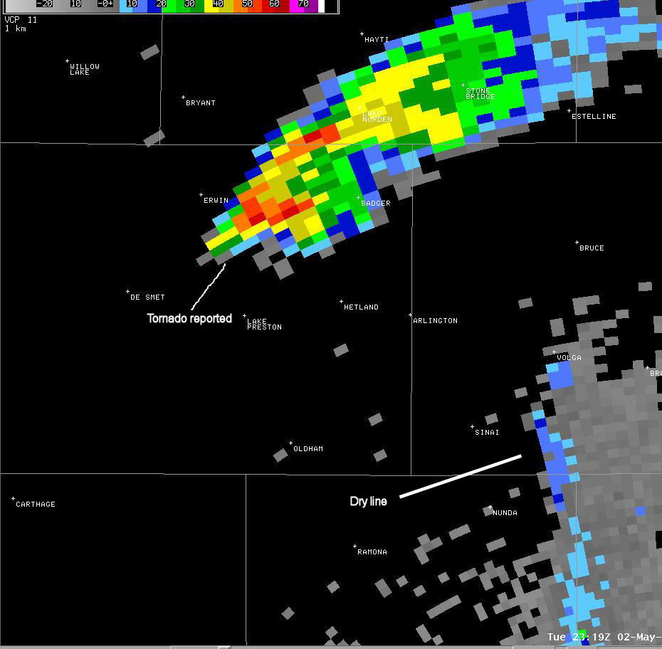
The storm began to develop around 5:49 pm. There was evidence of a thunderstorm developing northwest of De Smet. A weak circulation was associated with this updraft. There also is evidence of a dryline east of Madison, South Dakota. While the dryline was not evident farther north, it is hypothesized that the dryline was located only a few miles east of this developing cell. The presence for a strong boundary is critical to the development of non-supercell tornadoes.
 |
 |
At 6:14 pm, the storm had intensified and the circulation had begun to strengthen. The circulation remained much weaker than what is typically seen with tornadic thunderstorms. Typically, the rotation on radar associated with a tornadic thunderstorms is greater than 40 mph. However, in this case, the rotation was between 10 and 20 mph. However, the rotation was rather narrow - only a couple of miles wide.
 |
 |
In the next 5 minutes the storm continued to intensify and at 6:19 pm cdt, the radar showed a strong storm over northeast Kingsbury County with some rotation. This is when the tornado touched down north of Lake Preston. The rotation reached its peak intensity on radar at this time and was just over 20 mph. In most environments, this would be considered a strong thunderstorm but one without a tornado threat. However, as discussed above, the presence of the boundary as well as a relatively warm and moist air mass, resulted in conditions favorable for tornado development even without the presence of a strong rotation on radar.
 |
 |
Below is a picture of the tornado from around this same time. Click the image for a larger view.

At 6:23 pm, the tornado destroyed portions of a hog confinement 4 miles north of Lake Preston. Here is how it looked on radar. While the reflectivity image shows heavy rain with some hail between Lake Preston and Erwin, there is no evidence of a "hook" that is sometimes observed with tornadoes. In addition, the rotation had weakened significantly on the radar. With both supercell and non-supercell tornadoes, weakening of the circulation on radar is observed as the rotation becomes concentrated near the surface and below the radar beam. Therefore, the tornado can last several minutes after it appears to "dissipate" on radar.
 |
 |
The storm began to rapidly weaken after 6:30 pm. The image below is from 6:48 pm. Note that the circulation is no longer evident and the storm relfectivity is no longer above 30 dBz. Calls to weather spotters north of Arlington indicated that the rotation within the storm had dissipated between 6:35 pm and 6:45 pm.
 |
 |
We have also included links to a couple of animated radar images. These animations are each around 700-750MB in size, so broadband/high speed connections are recommended for downloading.


 Weather Story
 Weather Map
 Local Radar
 Follow us on YouTube