
Showers and thunderstorms capable of producing widespread heavy rainfall will be possible across much of Puerto Rico today. Heavy rainfall will likely lead to flash, urban and small stream flooding. Some areas may face life-threatening flooding. In the Southeast U.S., strong to marginally severe thunderstorms will be possible this afternoon. Read More >
North Texas Severe Weather April 23, 2008
Erath-Palo Pinto and Tarrant-Johnson Counties
|
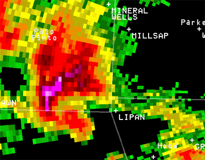
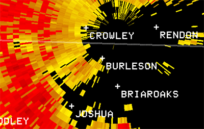
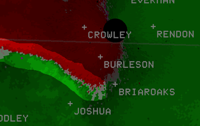
During the late afternoon hours on Wednesday, April 23, 2008, supercell thunderstorms spread from west Texas into parts of north Texas. Additional thunderstorms developed through the evening hours as the complex of thunderstorms moved east. Reports of tornadoes, very large hail, damaging straight-line winds, and flash flooding accompanied the thunderstorms. (Read the Local Storm Report Summary) The WSR-88D radar images below show a supercell thunderstorm near the Erath - Palo Pinto County line at 647 pm CDT. The bright red and pink colors in the radar reflectivity represent values up to 70 dBZ that were caused by very large hailstones. Also note the distinct hook echo on the southern part of the storm straight west of Lipan. The Doppler Velocity image, also taken at 647 pm CDT, shows a large, well-defined counterclockwise circulation pattern across extreme northern Erath County. The red colors in the storm-relative mean radial velocity image indicate winds blowing AWAY from the radar located at KFWS (Fort Worth Spinks airport); the green colors represent winds blowing toward the radar (or from west to east). This supercell thunderstorm prompted the issuance of Tornado Warnings across this area Wednesday evening. This statement gives a brief summary of the known tornadoes that occurred in this area. |
|
|
|
|
|
KFWS Reflectivity Image at 6:47 pm CDT - April 23, 2008 |
KFWS Storm Relative Velocity Image at 6:47 pm CDT - April 23, 2008 |
|
These two WSR-88D images were taken at a radar elevation angle of 1.5 degrees at 832 pm CDT on 4/23/08. Intense thunderstorms were moving |
|
|
|
|
|
KFWS Reflectivity Image at 8:32 pm CDT - April 23, 2008 (1.5 degrees) |
KFWS Storm Relative Velocity Image at 8:32 pm CDT - April 23, 2008 |


 Follow us on YouTube