
Highlights of the 2024 Total Solar Eclipse as it crossed North and Central Texas on Monday April 8th. Read More >
 |
 |
December 2013 marks the 30-year anniversary of the coldest December on record for north Texas.
The month of December 1983 remains in the record books as the coldest December for both Dallas-Fort Worth and Waco. Temperatures on average across the region were 12.1 degrees Fahrenheit below normal for the month (Figure 1). In the Dallas-Fort Worth area, average temperatures during December 1983 were 4 degrees colder than any other December on record!
A very active weather pattern during December 1983 brought all types of weather consisting of: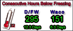
Tornadoes in east and southeast Texas on the 10th
A significant snow storm across north and east Texas on the 15th and 16th, and finally
Extreme cold during the end of the month
 A series of upper level systems and surface cold fronts affected north Texas during the month of December 1983 contributing to the varied weather. A total of seven cold fronts have been identified that aided in dropping temperatures at the end of the month below the freezing mark for about 10 consecutive days! On December 10th, severe thunderstorms developed ahead of a dryline and cold front producing 12 tornadoes in east and southeast Texas, including four F2 tornadoes. Another cold front on the 15th brought a significant snow storm to north and east Texas on the 15th and 16th.
 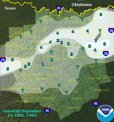 Snowfall totals ranged from a trace to over 8 inches, and approximately 15,000 electric customers were without power for nearly 36 hours. In north Texas, the highest snowfall recorded from this event was 8.5” at a volunteer weather observing site in southern Rains County. Several weather observers reported that the snowfall on the 15th and 16th remained on the ground through the remainder of the month.
The arrival of the front on the 15th brought the first nights of freezing temperatures to north Texas, but the most significant front arrived in north Texas on the 18th (Figures 2, 3 & 4). This front brought bitterly cold arctic air to north Texas followed by three more fronts on the 21st, 24th, and 28th. The air behind all of the fronts during the latter half of the month had origins from the Arctic. The highest sea level pressure ever recorded in Dallas-Fort Worth occurred behind the front on the 24th when the surface pressure rose to 31.06 inches!
Beginning on the 18th, temperatures in several locations in north Texas started falling below freezing and remained below freezing in some locations until January. DFW International Airport reported a record 295 consecutive hours with temperatures below freezing from the morning of the 18th until the afternoon of the 30th (Figure 5). Waco Airport (called Madison Cooper Airport in 1983) recorded a total of 151 consecutive hours with temperatures below freezing beginning on the morning of the 21st and ending on the afternoon of the 27th (Figure 6). A comparison of the two climate sites is in the table below.
|
|
DFW International Airport |
Waco Airport |
|
Average Monthly Temperature (Departure From Normal) |
34.8 (-11.9) |
38.3 (-10.0) |
|
Average Monthly Maximum Temperature (Departure From Normal) |
43.4 (-13.1) |
48.1 (-11.0) |
|
Average Monthly Minimum Temperature (Departure From Normal) |
26.1 (-10.7) |
28.5 (-9.0) |
|
Coldest Temperature Recorded (Date, December 1983) |
5 (22nd) |
7 (25th) |
|
Number of Daily Minimum Temperature Records that still stand from December 1983 |
6 |
7 |
|
Number of Daily Low Maximum Temperature Records that still stand from December 1983 |
5 |
4 |
December 1983 Temperature Summary for north Texas climate sites. All temperatures are in degrees Fahrenheit.
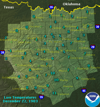
The extent of the cold weather was also well documented by volunteer weather observers across north Texas. Most sites recorded temperatures below freezing from the 19th-29th, but some sites along the Red River and in the northeastern portions of north Texas reported temperatures remaining below freezing into January 1984. These sites included Gainesville, Monkstown, Paris, Sherman, Emory, and Sulphur Springs. The coldest temperature recorded in north Texas during this month was -2 degrees Fahrenheit at Glen Rose 2W on the 30th.
A summary of the event in Storm Data (NCDC 1984) indicated that six people in north Texas lost their lives as a result of the cold temperatures and over a hundred were injured. Residents in several communities lost gas and electric as these companies were forced to close area plants and businesses. Water line breaks were also a problem, especially for the Fort Worth Water Department who spent nearly $1.5 million to repair city water lines, not including homes and businesses. Agricultural losses were estimated to be in the tens of millions of dollars with initial insurance claims over $50 million. Both Eagle Mountain Lake and Lake Worth froze over. The extreme cold affected not only north Texas but also the entire state of Texas and the eastern two-thirds of the country. In Texas alone, damage from the cold was estimated at $50-100 million. At least 151 deaths nationwide were attributed to the prolonged cold period, many of which occurred in the south and southeast parts of the country.
Even though December 1983 was the coldest December on record for north Texas, the coldest temperatures ever recorded in this month occurred in later years. For Dallas-Fort Worth, the coldest temperature ever recorded in the month of December was -1 degrees Fahrenheit in 1989. The coldest temperature ever recorded in December in Waco was -4 degrees Fahrenheit in 1989. For additional information on climate records for Dallas-Fort Worth and Waco, visit our climate site at: https://www.srh.noaa.gov/fwd/?n=ntexclima.
Figure 1: Plot of monthly average temperature anomalies across the country for the month of December 1983. The anomalies are plotted in degrees Fahrenheit. Anomalies across north Texas for the month ranged from -10 to -13 degrees Fahrenheit. An anomaly is a departure from normal. (Image courtesy of Storm Data Publication, NCDC 1984.)
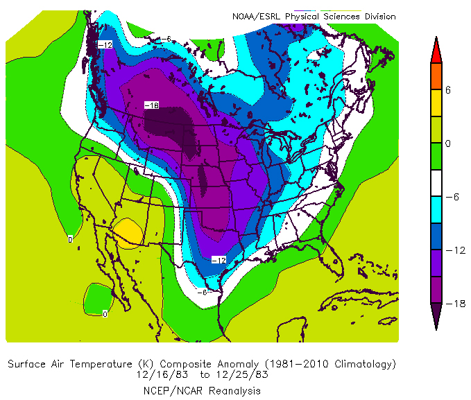
Figure 2: Surface air temperature anomalies for the 10-day period between Dec 16th and 25th, 1983. Colors represent the departure from normal in degrees Celsius per the scale on the right. This image shows very cold air with temperature departures of over -18 degrees Celsius behind the second arctic cold front of the month. (Image courtesy of NOAA/ESRL Physical Sciences Division at: https://www.esrl.noaa.gov/psd/data/composites/day/.)
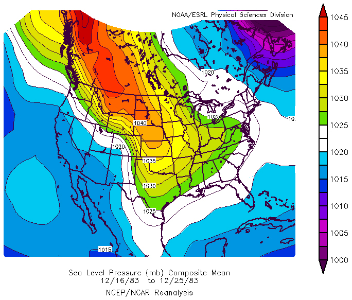
Figure 3: Composite Mean Sea Level Pressure for the 10-day period between Dec 16th and the 25th, 1983. Note the surface high pressure ridge extending from northern Canada into south Texas.
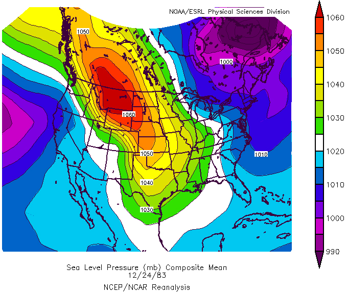
Figure 4: Mean Sea Level Pressure in millibars on 12/24/83. Note the sea level pressure above 1060 mb in Montana and southern Canada.
Figure 5: Plot of daily maximum and minimum temperatures at DFW International Airport for the month of December 1983. Daily normal maximum and minimum temperatures for the month of December are also plotted as a light red and light blue line, respectively.

Figure 6: Plot of daily maximum and minimum temperatures at Waco Airport for the month of December 1983. Daily normal maximum and minimum temperatures for the month of December are also plotted as a light red and light blue line, respectively.


 Follow us on YouTube