
Showers and thunderstorms capable of producing widespread heavy rainfall will be possible across much of Puerto Rico today. Heavy rainfall will likely lead to flash, urban and small stream flooding. Some areas may face life-threatening flooding. In the Southeast U.S., strong to marginally severe thunderstorms will be possible this afternoon. Read More >
Forecast Type Guide
Point-n-Click
Currently experimental, this suite of forecasts offers new and exciting ways of presenting forecasts on a smaller scale, both temporally and spatially. The forecasts are actually done by your Ft. Worth National Weather Service forecasters! The data used for the forecasts is created through our Interactive Forecast Preparation System (IFPS).
Point-n-click forecasts are on a more "neighborhood" type scale, as forecast grid points are currently at a 5km spacing. This "neighborhood" forecast may differ, at times, from the County Averaged forecast, due simply to the smaller scale of forecast parameters used to generate the text. Differences between the Point-n-click forecasts and the County Averaged forecasts may also occur since the text is formatted from the data in slightly different ways. However, it is important to note that even the County Averaged forecasts are derived from the data the the forecaster had entered into the IFPS system.
Currently the "neighborhood", or Point-n-Click forecast, is displayed, by default, from our main homepage.
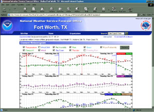
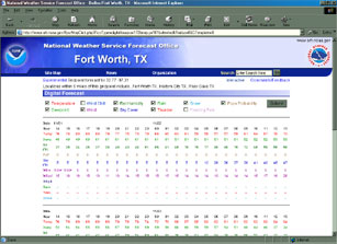
Point-n-Click also allows us to offer exciting new ways to display forecast elements. The Element Forecast Meteorogram show various user selectable forecast elements, on an hourly basis, based upon a gridded data forecast point. The Digital Tabular Forecast is similar to the Meteorogram, but it shows the data in a different format.
|
The Element Forecast Meteorogram |
The Digital Tabular Forecast |
 |
 |
County Averaged
County Averaged forecasts are the official forecasts created by the National Weather Service in Ft. Worth.
Forecast text is also generated by entering data through ourInteractive Forecast Preparation System (IFPS), but the text is generated based upon groupings of counties where the weather is expected to be similar. This may result in a slightly different forecast than that from the Point-n-Click system. The County Averaged forecast is simply reading our Zone Forecast Product (ZFP) and breaking the forecasts back up to the county level.
Digital (AFM)
TheDigital AFM is yet another way to display forecast parameters that are generated by forecasters at the National Weather Service Forecast in Ft. Worth. Similar to the Digital Tabular Forecast, forecast elements are broken down to 3 hour snap shots for a grouping of counties. Codes in the product make it look quite similar to data that is output from computer forecast models. The grouping of counties is the same that is used for the County Averaged Forecast, which is to say the same as in the Zone Forecast Product.
Graphical AFM
The Graphical AFM decodes the Digital RDF product in a manner that is more easily understood. It presents the forecast parameters with graphical images and allow users to quickly get a more detailed forecast. It to, however, is based upon groupings of counties. This forecast is currently experimental.
Forecast Images
Your Official National Weather Service Forecast from Ft. Worth, Texas is actually derived by forecaster images of sensible weather elements. This is done through theInteractive Forecast Preparation System (IFPS). The Forecast Images are actual copies (in .png format) of the images the forecaster created to come up with all the forecasts for the day. The images provide yet another way to view forecast elements in higher resolution.
Aviation
The National Weather Service Forecast office in Ft. Worth, Texas produces Terminal Aerodome Forecasts (TAF's) for several airports across North Texas. Currently we link the Aviation section to our National Aviation Weather Center. This allows pilots to view much more weather information than is produced in the TAF products.
Fire Weather
Fire Weather Forecasts are generated to assist other governmental agencies in the protection of life and property. Governmental agencies can use this section of forecasts to request spot forecasts and to view other weather information they require.


 Follow us on YouTube