
A few strong to marginally severe thunderstorms are possible across the Southeast U.S. Friday. A Marginal Risk (Level 1 of 5) outlook has been issued. Strong winds and hail will be the main threats. Elevated to locally critical fire weather conditions will persist across south-central Colorado today due to dry conditions and gusty winds. Read More >
North Texas
NOAA Weather Radio Coverage
Scroll Down This Page For A County Coverage Listing that Includes FIPS Codes
|
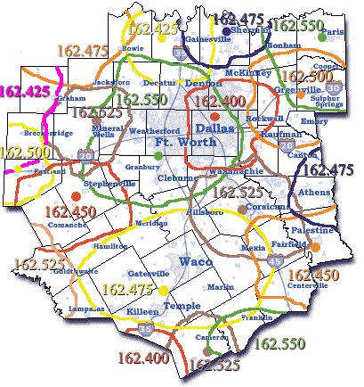
The map to the left depicts an estimated coverage pattern for the current array of NOAA Weather Radio transmitters across the forecast and warning responsibility area (County Warning Area) of the Fort Worth/Dallas office of the National Weather Service. Transmitters typically have a reliable range of 40 miles, but terrain features, quality of receivers, antenna locations, and various atmospheric conditions can affect the reliable reception range. The map is provided simply as a guide to indicate where NOAA Weather Radio reception should be possible. In many case, as seen in the map, you may need to experiment with different frequencies to find the best reception in your area.
NOAA Weather Radio broadcasts on the following frequencies across the country.
|
|
County |
FIPS |
Frequency |
Programing Office |
| Anderson | 048001 | 162.450 | FTW |
| 162.475 | SHV | ||
| 162.525 | FTW | ||
| Bell | 048027 | 162.475 | FTW |
| Bosque | 048035 | 162.450 | FTW |
| 162.475 | FTW | ||
| Collin | 048085 | 162.400 | FTW |
| 162.550 | FTW | ||
| 162.475 | FTW | ||
| 162.500 | FTW | ||
| Comanche | 048093 | 162.450 | FTW |
| Cooke | 048097 | 162.475 | FTW |
| Coryell | 048099 | 162.475 | FTW |
| Dallas | 048113 | 162.400 | FTW |
| 162.550 | FTW | ||
| Delta | 048119 | 162.550 | FTW |
| 162.500 | FTW | ||
| Denton | 048121 | 162.400 | FTW |
| 162.475 | FTW | ||
| 162.550 | FTW | ||
| Eastland | 048133 | 162.450 | FTW |
| Ellis | 048139 | 162.400 | FTW |
| 162.550 | FTW | ||
| 162.525 | FTW | ||
| Erath | 048143 | 162.450 | FTW |
| 162.550 | FTW | ||
| Falls | 048145 | 162.475 | FTW |
| Fannin | 048147 | 162.500 | FTW |
| 162.475 | FTW | ||
| 162.550 | FTW | ||
| Freestone | 048161 | 162.450 | FTW |
| 162.525 | FTW | ||
| Grayson | 048181 | 162.475 | FTW |
| Hamilton | 048193 | 162.450 | FTW |
| Henderson | 048213 | 162.475 | SHV |
| 162.525 | FTW | ||
| 162.450 | FTW | ||
| Hill | 048217 | 162.475 | FTW |
| 162.525 | FTW | ||
| Hood | 048221 | 162.550 | FTW |
| 162.450 | FTW | ||
| Hopkins | 048223 | 162.500 | FTW |
| 162.550 | FTW | ||
| Hunt | 048231 | 162.400 | FTW |
| 162.500 | FTW | ||
| 162.550 | FTW | ||
| Jack | 048237 | 162.525 | FTW |
| Johnson | 048251 | 162.400 | FTW |
| 162.550 | FTW | ||
| Kaufman | 048257 | 162.400 | FTW |
| 162.525 | FTW | ||
| 162.500 | FTW | ||
| Lamar | 048277 | 162.550 | FTW |
| 162.500 | FTW | ||
| Lampasas | No | NWR | Coverage |
| Leon | 048289 | 162.550 | HOU |
| 162.450 | FTW | ||
| Limestone | 048293 | 162.475 | FTW |
| 162.525 | FTW | ||
| McLennan | 048309 | 162.475 | FTW |
| Milam | 048331 | 162.550 | HOU |
| 162.475 | FTW | ||
| 162.525 | FTW | ||
| Mills | 048333 | 162.525 | SJT |
| Montague | 048337 | 162.425 | FTW |
| Navarro | 048349 | 162.525 | FTW |
| Palo Pinto | 048363 | 162.450 | FTW |
| Parker | 048367 | 162.550 | FTW |
| Rains | 048379 | 162.500 | FTW |
| Robertson | 048395 | 162.550 | HOU |
| 162.475 | FTW | ||
| Rockwall | 048397 | 162.400 | FTW |
| Somervell | 048425 | 162.550 | FTW |
| 162.450 | FTW | ||
| Stephens | 048429 | 162.500 | FTW |
| 162.525 | FTW | ||
| Tarrant | 048439 | 162.550 | FTW |
| 162.400 | FTW | ||
| Van Zandt | 048467 | 162.475 | SHV |
| 162.500 | FTW | ||
| Wise | 048497 | 162.550 | FTW |
| Young | 048503 | 162.425 | SJT |
| 162.525 | FTW | ||
| FTW=Ft. Worth SHV=Shreveport HOU=Houston SJT=San Angelo OUN = Oklahoma City |
|||


 Follow us on YouTube