
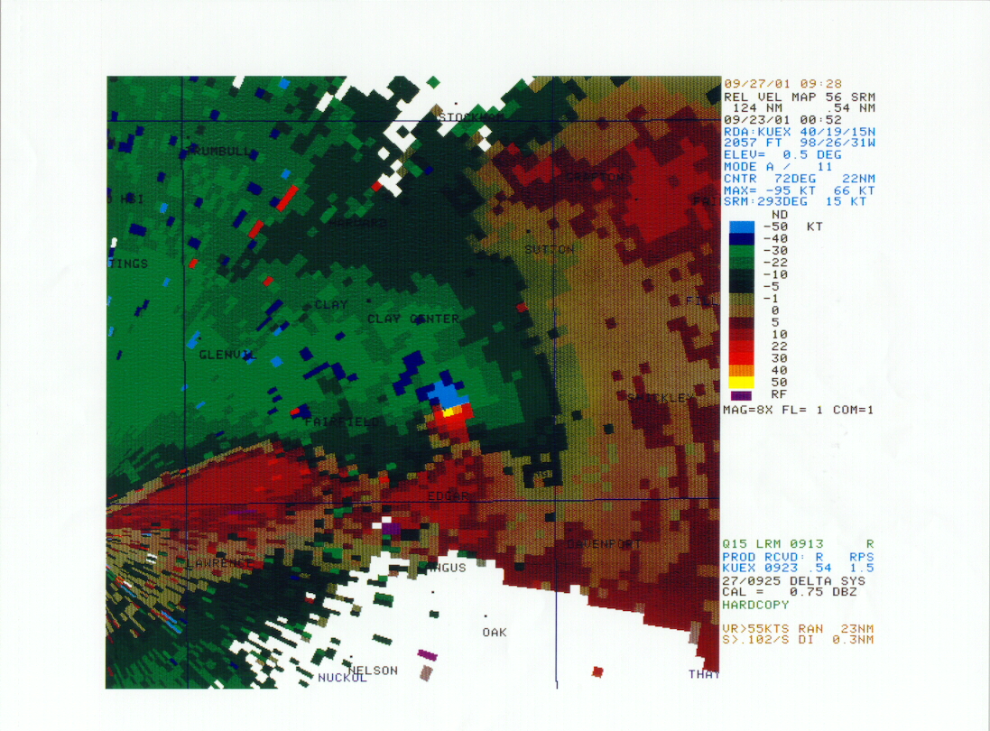
On the left...radar imagery shows the classic "hook" shaped echo over southeast Clay County.
At right..."Doppler velocity couplet" with winds blowing toward the radar (bottom center) in green and blue (max) and winds blowing away from the radar in red and yellow (max). The color scale indicates at least 50 kts (58 mph) in each direction, or at least 116 mph of shear over southeast Clay County.
One tornado formed west of Saronville in northeast Clay County at approximately 7:07 pm. The tornado was about 200 yards wide and damaged crops and irrigation equipment along its nearly 4 mile long path. It then dissipated around 726 pm.
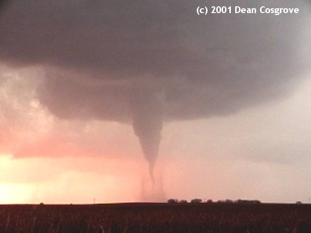
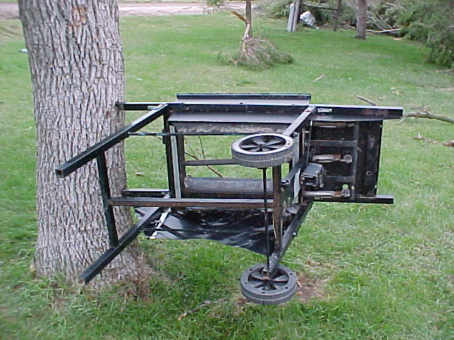
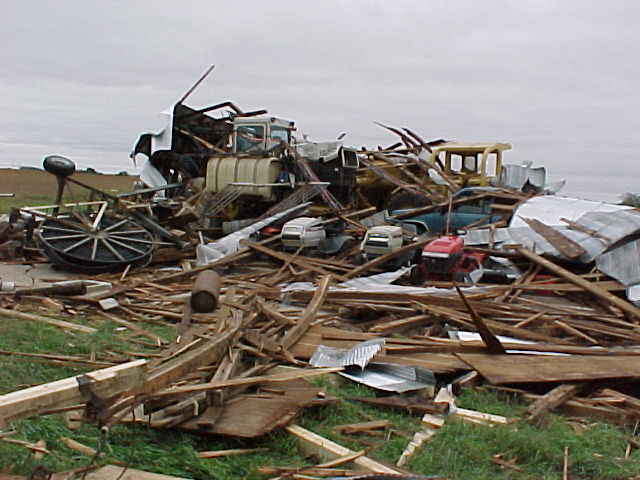
A larger tornado formed about six or seven miles south of where the initial tornado weakened. This tornado moved southeast, east, and finally northeast on its 8 mile long path. It was a half mile wide for much of its lifetime, but reached 0.8 miles at its widest. The tornado damaged three farmsteads in an area bounded by Clay Center, Edgar and Ong. The extent of the damage indicates that this tornado reached F3 intensity on the Fujita Scale, with wind speeds between 158 and 206 mph.
Hail pounded the area as well both in the morning, and again during the evening. Hail as large as 4 inches in diameter was reported in Jewell County Kansas.
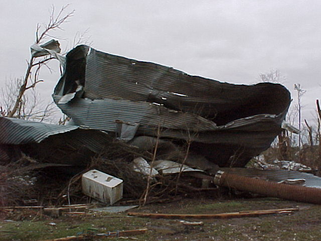
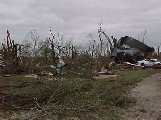
Below are pictures of the devastation left from the large tornado in Clay County.
Click on an image for the enlarged view.
The following are PRELIMINARY severe weather reports from September 22nd.

TIME(CDT)  CITY LOCATION            STATE  EVENT/REMARKS               COUNTY LOCATION
0505 AM EDGAR NE .75 INCH HAIL 09/22/01 CLAY
0515 AM 5 E STOCKHAM NE 0.75 INCH HAIL 09/22/01 HAMILTON
0515 AM CLAY CENTER NE 1.00 INCH HAIL 09/22/01 CLAY COVERING THE GROUND
0740 AM FAIRMONT NE 0.75 INCH HAIL 09/22/01 FILLMORE REPORTED BY COUNTY SHERIFF.
0710 PM 1 W SARONVILLE NE TORNADO 09/22/01 CLAY
0736 PM 10 E CLAY CENTER NE 1 INCH HAIL 09/22/01 CLAY
0750 PM 2 N EDGAR NE TORNADO 09/22/01 CLAY
0750 PM 3 W ONG NE 1 INCH HAIL 09/22/01 CLAY REPORTED BY STORMCHASER
0750 PM    3 W ONG                   NE    TORNADO          09/22/01   CLAY         QUARTER MILE WIDE TORNADO
                                                                                    REPORTED BY STORMCHASER
0800 PM 4 N ONG NE 1.75 INCH HAIL 09/22/01 CLAY EVENT DURATION 30 MIN
0810 PM 4 NE EDGAR NE TORNADO 09/22/01 CLAY HOUSE DESTROYED
0815 PM 4 W SHICKLEY NE TORNADO 09/22/01 FILLMORE
0815 PM 1 E ONG NE TORNADO 09/22/01 CLAY
0830 PM MC COOL JCT NE 1.25 INCH HAIL 09/22/01 YORK
0855 PM 5 N SUPERIOR NE 1 INCH HAIL 09/22/01 NUCKOLLS
0855 PM 2 NE NORTH BRANCH KS 3.5 INCH HAIL 09/22/01 JEWELL
0855 PM 3 NE NORTH BRANCH KS 4 INCH HAIL 09/22/01 JEWELL
0900 PM SUPERIOR NE 1 INCH HAIL 09/22/01 NUCKOLLS
0900 PM 5 N BURR OAK KS 2.5 INCH HAIL 09/22/01 JEWELL REPORTED BY SPOTTER
0935 PM FORMOSO KS .75 INCH HAIL 09/22/01 JEWELL
0935 PM WEBBER KS .75 INCH HAIL 09/22/01 JEWELL
0935 PM MANKATO KS .75 INCH HAIL 09/22/01 JEWELL


 Follow us on YouTube