Overview/Narrative:
(BE SURE TO CLICK THE VARIOUS TABS BELOW FOR A VARIETY OF SEPTEMBER 2018 CLIMATE INFORMATION!)
|
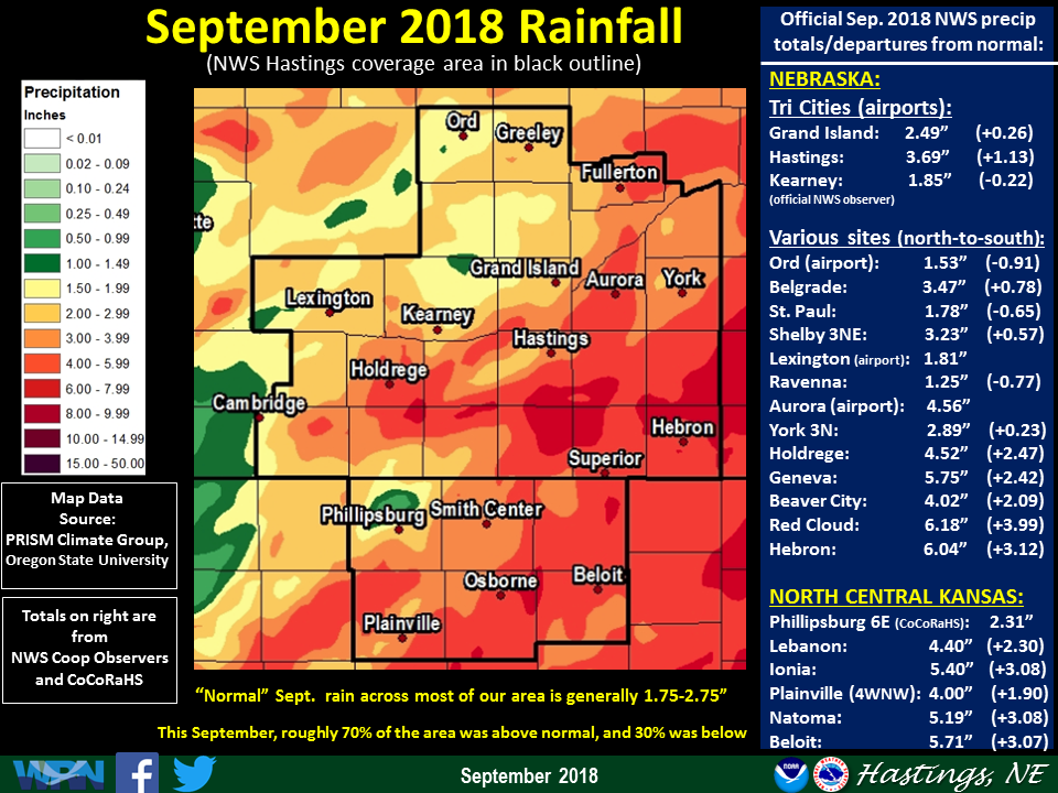
Recap of September 2018 Weather for the 30-county NWS Hastings Coverage Area:
|
Grand Island & Hastings Details (Including 12-Month History):
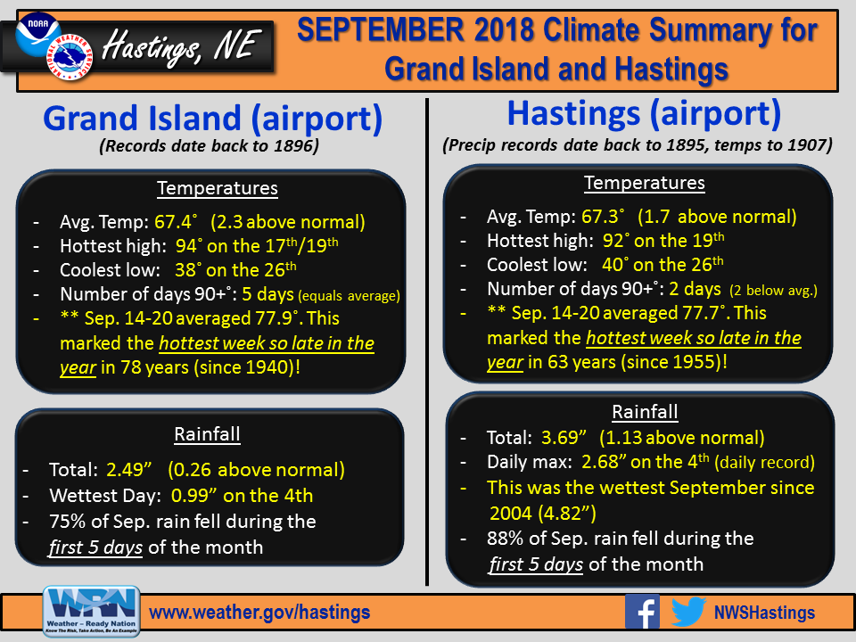 |
| Detailed September 2018 info for Grand Island/Hastings (Click to enlarge) |
 |
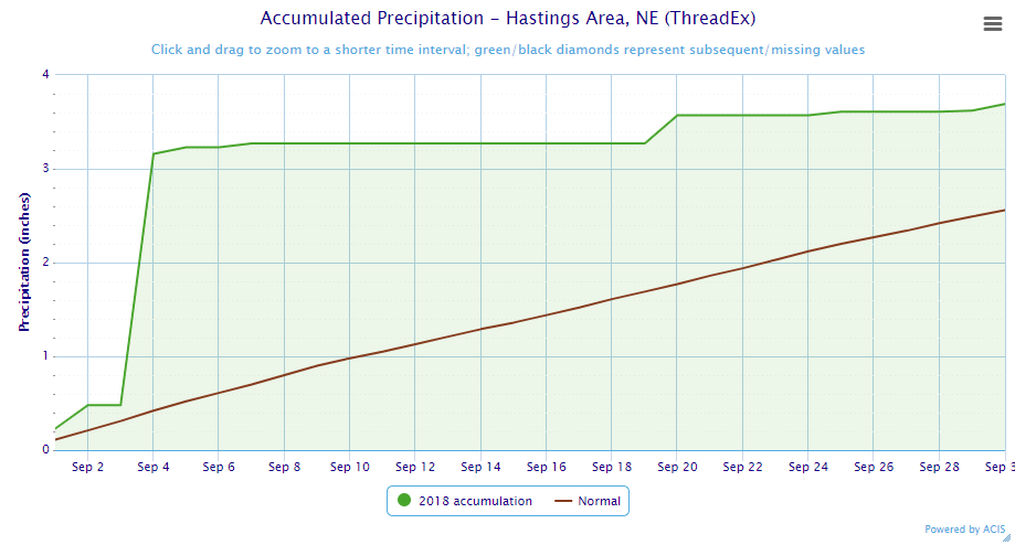 |
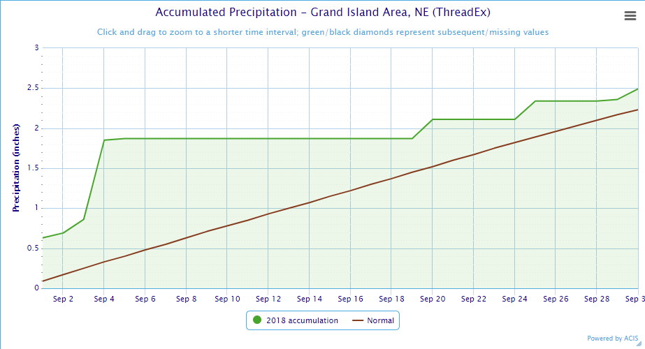
| Grand Island Precipitation Summary: The green line indicates cumulative observed precipitation for September 2018.The brown line indicates "normal" September precipitation based on 30-year data from 1981-2010. (click to enlarge) | Hastings Precipitation Summary: The green line indicates cumulative observed precipitation for September 2018. The brown line indicates "normal" September precipitation based on 30-year data from 1981-2010. (click to enlarge) |
| Grand Island (Regional Airport ASOS) - Oct. 2017 - Sept. 2018 | ||||||||||||
| Oct. | Nov. | Dec. | Jan. | Feb. | Mar. | Apr. | May | June | July | Aug. | Sept. | |
| Average High (F) | 65.2 | 53.4 | 37.3 | 34.0 | 33.6 | 51.8 | 55.4 | 78.6 | 88.2 | 85.8 | 84.3 | 77.4 |
| Average Low (F) | 40.2 | 28.7 | 16.0 | 13.5 | 12.5 | 28.8 | 30.8 | 55.5 | 64.8 | 64.6 | 62.5 | 57.4 |
| Average Temperature (F) | 52.7 | 41.1 | 26.6 | 23.7 | 23.1 | 40.3 | 43.1 | 67.0 | 76.5 | 75.2 | 73.4 | 67.4 |
| Departure From Normal | +0.5 | +3.0 | -0.1 | -1.4 | -6.0 | +0.9 | -7.5 | +5.8 | +5.2 | -1.0 | -0.6 | +2.3 |
| Precipitation (in) | 5.36 | 0.51 | 0.45 | 1.08 | 0.75 | 1.26 | 1.26 | 3.98 | 4.61 | 3.58 | 2.67 | 2.49 |
| Departure From Normal | +3.50 | -0.66 | -0.18 | +0.55 | +0.07 | -0.54 | -1.27 | -0.43 | +0.31 | +0.18 | -0.45 | +0.26 |
| Snowfall (in) | 0.9 | 0.2 | 7.2 | 10.2 | 10.6 | 0.4 | 4.1 | 0.0 | 0.0 | 0.0 | 0.0 | 0.0 |
| Departure From Normal | -0.1 | -2.9 | +2.1 | +3.7 | +4.3 | -5.0 | +2.6 | 0.0 | 0.0 | 0.0 | 0.0 | -0.1 |
| Hastings (Municipal Airport ASOS) - Oct. 2017 - Sept. 2018 | ||||||||||||
| Oct. | Nov. | Dec. | Jan. | Feb. | Mar. | Apr. | May | June | July | Aug. | Sept. | |
| Average High (F) | 64.9 | 53.1 | 37.9 | 35.3 | 34.3 | 52.3 | 55.6 | 78.2 | 87.0 | 85.5 | 83.3 | 76.4 |
| Average Low (F) | 40.8 | 28.6 | 15.9 | 14.3 | 12.4 | 27.8 | 30.6 | 55.6 | 65.0 | 65.1 | 63.1 | 58.2 |
| Average Temperature (F) | 52.9 | 40.9 | 26.9 | 24.8 | 23.4 | 40.1 | 43.1 | 66.9 | 76.0 | 75.3 | 73.2 | 67.3 |
| Departure From Normal | +0.3 | +2.2 | -0.7 | -1.2 | -6.5 | +0.2 | -7.6 | +5.6 | +4.2 | -1.8 | -1.1 | +1.7 |
| Precipitation (in) | 4.69 | 0.08 | 0.28 | 0.49 | 0.53 | 1.07 | 1.26 | 3.83 | 5.91 | 2.19 | 4.40 | 3.69 |
| Departure From Normal | +2.70 | -1.21 | -0.33 | +0.08 | +0.04 | -0.72 | -1.30 | -0.74 | +2.11 | -1.55 | +1.10 | +1.13 |
| Snowfall (in) | 0.2 | 0.0 | 5.8 | 5.9 | 8.0 | 0.3 | 6.9 | 0.0 | 0.0 | 0.0 | 0.0 | 0.0 |
| Departure From Normal | -1.0 | -2.6 | -0.3 | -0.1 | +1.5 | -4.9 | +5.7 | 0.0 | 0.0 | 0.0 | 0.0 | -0.2 |
Kearney - 12 Month Climate History:
All data here is from the official NWS observer at Kearney airport, with 24-hour observations taken around 7 a.m. ** PLEASE NOTE: This official Kearney data often differs slightly from the unofficial data recorded by the automated airport system (KEAR) **
| Kearney Airport (Coop Observer) - Oct. 2017 - Sept. 2018 | ||||||||||||
| Oct. | Nov. | Dec. | Jan. | Feb. | Mar. | Apr. | May | June | July | Aug. | Sept. | |
| Average High (F) | 65.9 | 52.3 | 38.7 | 32.2 | 32.9 | 51.9 | 53.8 | 75.9 | 86.6 | 84.6 | 82.3 | 77.6 |
| Average Low (F) | 40.0 | 26.8 | 15.5 | 11.1 | 10.6 | 26.1 | 28.6 | 52.7 | 62.9 | 63.0 | 59.9 | 55.8 |
| Average Temperature (F) | 53.0 | 39.6 | 27.1 | 21.6 | 21.7 | 39.0 | 41.2 | 64.3 | 74.7 | 73.8 | 71.1 | 66.7 |
| Departure From Normal | +2.1 | +2.6 | +1.2 | -3.0 | -6.4 | +1.3 | -7.5 | +4.8 | +4.9 | -0.9 | -1.5 | +3.2 |
| Precipitation (in) | 2.83 | 0.34 | 0.21 | 0.96 | 0.73 | 1.05 | 2.03 | 5.56 | 2.87 | 6.07 | 2.05 | 1.85 |
| Departure From Normal (in) | +0.79 | -0.68 | -0.36 | +0.47 | +0.18 | -0.74 | -0.20 | +1.38 | -1.06 | +2.79 | -1.03 | -0.22 |
| Snowfall (in) | 0.0 | 0.4 | 4.3 | 6.8 | 9.2 | 0.7 | 9.7 | 0.0 | 0.0 | 0.0 | 0.0 | 0.0 |
| Departure From Normal (in) | -0.7 | -2.7 | +0.8 | +2.4 | +4.1 | -3.9 | +7.9 | 0.0 | 0.0 | 0.0 | 0.0 | -0.2 |
Ord - 12 Month Climate History:
Winter precipitation totals often include NWS Cooperative Observer data due to the automated airport equipment under-measuring snowfall liquid equivalent.
| Ord (Evelyn Sharp Field ASOS) - Oct. 2017 - Sept. 2018 | ||||||||||||
| Oct. | Nov. | Dec. | Jan. | Feb. | Mar. | Apr. | May | June | July | Aug. | Sept. | |
| Average High (F) | 63.7 | 53.4 | 36.6 | 34.3 | 31.2 | 49.9 | 54.1 | 75.4 | 84.0 | 84.0 | 82.2 | 75.4 |
| Average Low (F) | 36.1 | 24.3 | 14.1 | 10.2 | 9.0 | 25.5 | 27.3 | 51.8 | 60.8 | 62.0 | 59.1 | 54.5 |
| Average Temperature (F) | 49.9 | 38.9 | 25.3 | 22.2 | 20.1 | 37.7 | 40.7 | 63.6 | 72.4 | 73.0 | 70.6 | 65.0 |
| Departure From Normal | +0.3 | +2.6 | +0.4 | -2.4 | -7.7 | 0.0 | -8.1 | +4.3 | +3.2 | -1.4 | -2.4 | +1.4 |
| Precipitation (in) | 5.37 | 0.21 | 0.43 | 0.83 | 0.53 | 0.62 | 1.47 | 4.38 | 7.57 | 5.84 | 2.57 | 1.53 |
| Departure From Normal (in) | +3.44 | -0.86 | -0.16 | +0.46 | +0.09 | -0.83 | -1.12 | +0.57 | +3.45 | +2.87 | -0.59 | -0.91 |
| Snowfall (in) | 0.0 | 2.0 | 5.3 | 12.4 | 8.6 | 1.1 | 10.1 | 0.0 | 0.0 | 0.0 | 0.0 | 0.0 |
| Departure From Normal (in) | -1.1 | -3.3 | -2.1 | +5.6 | +2.6 | -4.8 | +7.6 | 0.0 | 0.0 | 0.0 | 0.0 | 0.0 |
Smith Center, KS - 12 Month Climate History:
All data is from the official NWS observer, with 24-hour observations taken around 7 a.m. As a result, data may vary slightly from true "Calendar Day" totals.
| Smith Center KS (NWS Coop Observer) - Oct. 2017 - Sept. 2018 | ||||||||||||
| Oct. | Nov. | Dec. | Jan. | Feb. | Mar. | Apr. | May | June | July | Aug. | Sept. | |
| Average High (F) | 70.5 | 55.9 | 43.6 | 39.1 | 39.4 | 57.8 | 58.4 | 82.7 | 92.2 | 90.7 | 86.9 | 80.9 |
| Average Low (F) | 40.1 | 28.5 | 17.6 | 12.6 | 13.5 | 27.9 | 29.6 | 55.6 | 63.9 | 65.5 | 62.5 | 57.6 |
| Average Temperature (F) | 55.7 | 42.2 | 30.6 | 25.9 | 26.4 | 42.8 | 44.0 | 69.1 | 78.0 | 78.1 | 74.7 | 69.3 |
| Departure From Normal | +0.9 | +1.8 | +1.8 | -1.8 | -5.6 | +1.2 | -8.5 | +5.4 | +4.0 | -1.6 | -2.5 | +1.1 |
| Precipitation (in) | 1.36 | 0.09 | 0.11 | 0.32 | 0.31 | 1.05 | 0.91 | 2.62 | 6.33 | 3.98 | 3.25 | 3.88 |
| Departure From Normal (in) | -0.52 | -1.13 | -0.55 | -0.17 | -0.27 | -0.82 | -1.36 | -1.30 | +2.72 | +0.11 | -0.05 | +1.84 |
| Snowfall (in) | 0.0 | 0.2 | 2.0 | 3.5 | 7.6 | T | 2.0 | 0.0 | 0.0 | 0.0 | 0.0 | 0.0 |
| Departure From Normal (in) | -0.4 | -1.6 | -1.2 | -0.2 | +3.5 | -2.6 | +1.4 | 0.0 | 0.0 | 0.0 | 0.0 | -0.2 |
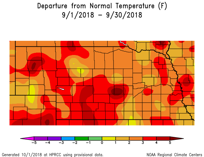
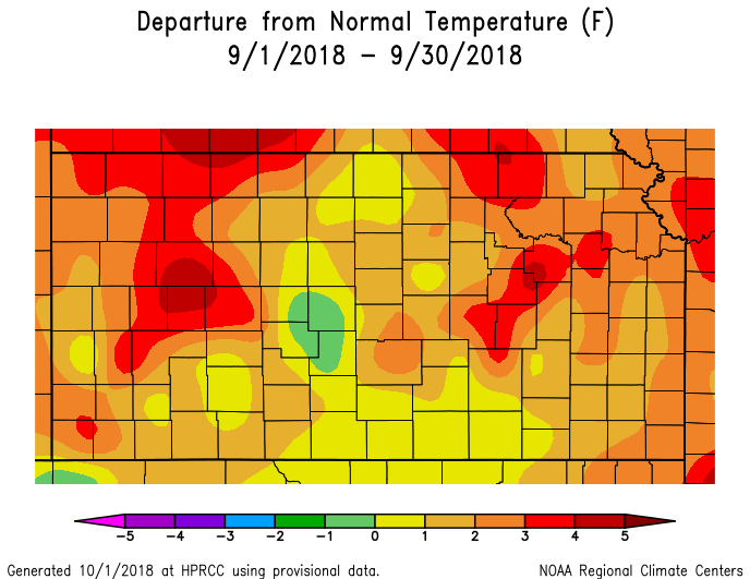
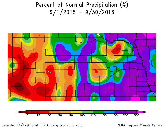
Temperature & Precipitation Departure From Normal Maps:
These images depict September 2018 monthly temperature departure from normal & precipitation percent-of-normal for both Nebraska & Kansas. Images are courtesy of the High Plains Regional Climate Center (HPRCC). Please note: These maps occasionally contain "bullseyes" of errant data. For precipitation, you can also generate departure from normal/percent-of-normal maps using the NWS AHPS page, or view local-area images generated each day by NWS Hastings.
 |
 |
 |
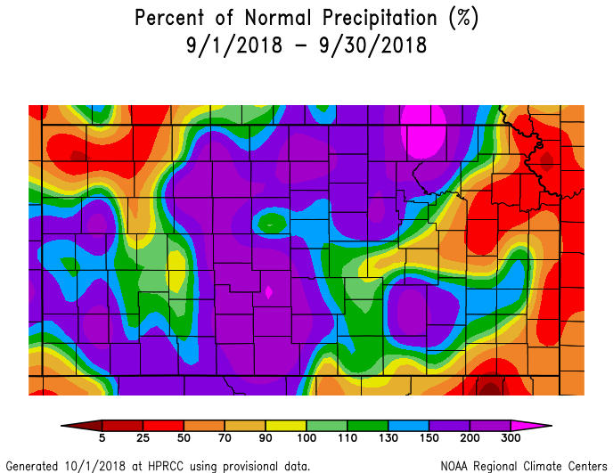 |
| Departure from Normal Temperature - NE (left) & KS (right) | Percent of Normal Precipitation - NE (left) & KS (right) | ||
Drought:
The following drought images, current as of October 2, 2018, are courtesy of the U.S. Drought Monitor
Summary of changes during September across the NWS Hastings coverage area:
Given that September rainfall was solidly above-normal within the handful of southeastern local counties that had previously featured Abnormally Dry (category D0) conditions throughout late July and August, this area of D0 went away completely from the ENTIRE NWS Hastings coverage area during the month! In other words, the entire local area was considered "drought-free" heading into October.
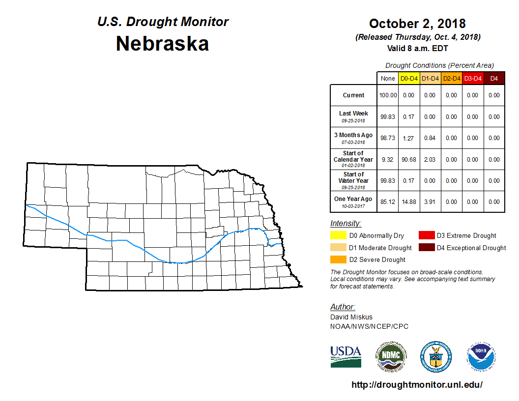 |
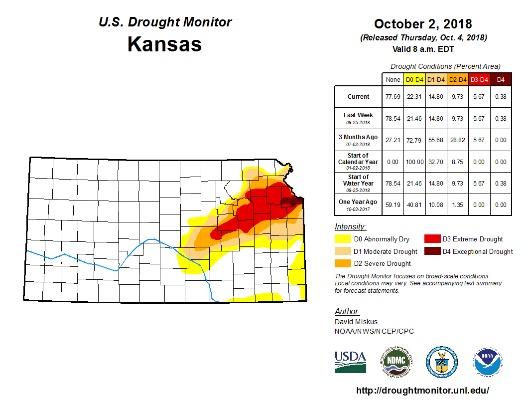 |
| Drought Monitor for Nebraska (left) & Kansas (right). Valid as of October 2, 2018 (click to enlarge) | |
September 2018 Extremes for the NWS Hastings Coverage Area:
...A FEW OF THE HOTTEST HIGH TEMPERATURES DURING SEPTEMBER 2018...
(all data from NWS cooperative observers or automated airport sites, with the date it actually occurred indicated in parentheses)
97 degrees....Cambridge (19th) - Webster Dam KS (20th)
96 degrees....Lexington Airport AWOS (19th) - Smith Center, KS (19th)
95 degrees...Hebron airport AWOS (18th/20th) - Beaver City (19th) - Kirwin Dam (18th)
...A FEW OF THE COOLEST LOW TEMPERATURES DURING SEPTEMBER 2018...
(all data from NWS cooperative observers or automated airport sites, with the date indicated in parentheses)
33 degrees...Ord Airport ASOS (26th)
34 degrees...Greeley (26th) - Ravenna (26th)
35 degrees...Cambridge (26th) - Beaver City (26th)
36 degrees...Edison (26th) - 6 NNW Oxford (26th)
...A FEW OF THE HIGHEST MONTHLY RAINFALL TOTALS DURING SEPTEMBER 2018...
(all data from NWS cooperative observers and CoCoRaHS/NeRAIN observers unless indicated)
8.20"...Deweese (5SSE)
8.11"...Lawrence (7SSE)
8.10"...Fairfield (2S) - Davenport
7.64"...Nelson
7.49"...Blue Hill
7.13"...Ohiowa (2NW)
7.10...Cawker City, KS
7.07"...Red Cloud (4E)
...A FEW OF THE LOWEST MONTHLY RAINFALL TOTALS DURING SEPTEMBER 2018...
(all data from NWS cooperative observers and CoCoRaHS/NeRAIN observers unless indicated)
1.24"...Cambridge - Ord
1.25"...Ravenna
1.42"...Logan KS
1.44"...Loup City
1.53"...Ord Airport ASOS
1.56"...Rockville (2NW)
1.57"...Arcadia (2W)
 |
Media use of NWS Web News Stories is encouraged! Please acknowledge the NWS as the source of any news information accessed from this site. |
|


 Follow us on YouTube