|
|
||
|
|
Looking Back at Weather Events in 2014...
|
|
|
Compared to years past, 2014 was a fairly quiet year in terms of the amount of weather occurrences, but on the days where extreme weather occurred, they were significant. We have described our 'Top Picks' for weather events in 2014 which impacted the NWS Hastings coverage area, encompassing 30 counties in south central Nebraska and north central Kansas. The top events are listed in chronological order. If you have any photographs to share or anything to add, please contact our webmaster, or post on or Facebook or Twitter accounts @NWSHastings. |
||
|
|
||
|
Top Weather Events: |
||
|
|
||
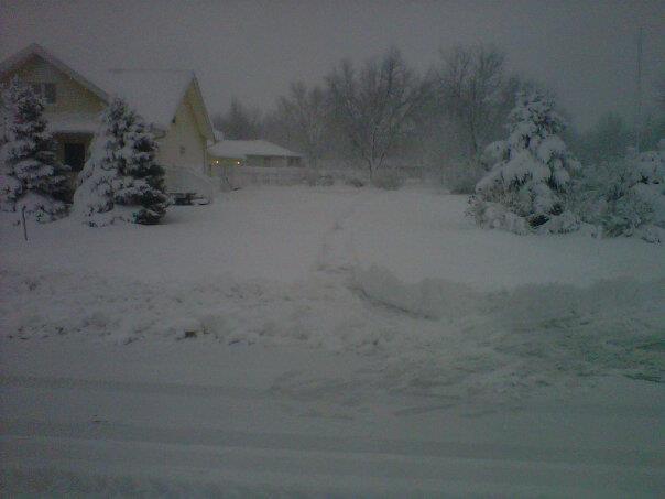
| February Snow - February 4th and February 22nd, 2014 | ||
 |
||
| Photo by KDOT web camera | ||
|
Winter came in full force on February 4th, as potent winter storm system produced widespread snowfall with amounts ranging from around 2 inches in the Ord area, to more significant amounts of 4 to 8 inches for locations south of a line from Hebron, NE to Phillipsburg, KS. The winter storm system was accompanied by an arctic cold front which caused temperatures to plummet during the day aboard stiff north wind gusts of 30 to 35 mph. The combination of the falling snow and gusty winds produced blowing and drifting snow and near white out conditions at times. The winter storm resulted in many cancellations of activities and numerous schools were closed the next day on February 5th. Bitter cold wind chills in the 20 to 30 degree below zero range settled in the morning on February 5th, and when all said and done, the region saw everything from snow to wind, blowing and drifting snow and frigid temperatures and wind chills. The latter part of February saw another significant snowfall event on the 22nd, but this time the heavy snowfall fell in a narrow band 10 to 15 miles wide. Within the snow band, the storm system dumped amounts of 6 to 9 inches in a swath from Cambridge to Elwood, NE southeast through Smith Center and Mankato, KS. Outside of the snow band, snowfall amounts rapidly decreased to the north and south and truly proves that some snow events are of the 'all or nothing' variety. |
||
|
|
||
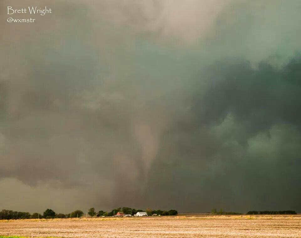
| Mother's Day Severe Weather and Tornado Outbreak - May 11, 2014 | ||
 |
||
| Photo by Brett Wright | ||
|
The severe weather was not limited to tornadoes, and there were several reports of very large hail ranging from quarter size to golf ball and hen egg size. Damaging wind gusts of 60 mph occurred in Osborne, KS. In addition, a swath of heavy rainfall fell from south of Hastings, NE to east of York, NE. The highest rainfall amounts occurred in York County where rainfall totals ranged from 3 to just over 7 inches, causing areas of flooding and led to numerous county road closures. |
||
|
|
||
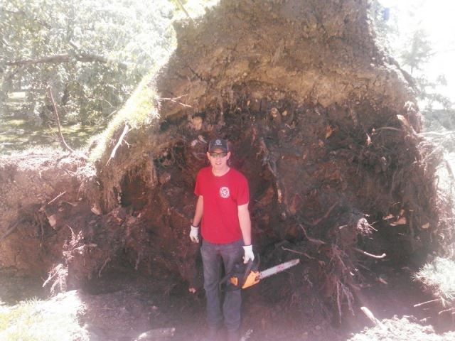
| Extreme Weather with Damaging Winds, Large Hail & Tornadoes - June 14, 2014 | ||
 |
||
| Photo by Mike Goebel | ||
| The evening of June 14th into the overnight hours on June 15th saw another severe weather outbreak across south central Nebraska and north central Kansas. An intense squall line produced widspread thunderstorm wind gusts in the 60 to 90 mph range with Phillipsburg, KS reporting an intense wind gust of 86 mph and Hastings, NE recorded a 79 mph wind gust! The intense winds uprooted and damaged trees and branches, as well as outbuildings, grain bins and power poles. Impressive hail the size of a softball fell three miles southeast of Hastings, and baseball size hail occurred in the Fullerton, Gibbon, Ayr, Hastings and Arapahoe areas. Many additional locations received reports of quarter to golf ball size hail. June 14th also ranked second for the most tornado touchdowns in a day, with five tornadoes reported. Four of the tornadoes were rated EF0, with one tornado rated an EF1. The EF1 tornado was the first tornado of the evening and touched down 10 miles west northwest of Stockton, KS. The tornado traveled one mile and damaged power poles and fencing. The EF0 tornadoes occurred southwest of Hildreth and Inavale, NE with two separate EF0 tornadoes occurring west and southwest of Giltner, NE. The thunderstorms also produced locally heavy rainfall of 2 to over 4 inches. | ||
|
|
||
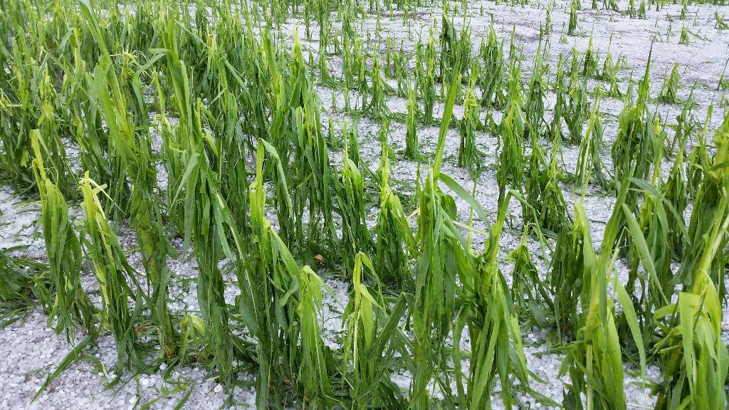
| Summer Snow? Copious amounts of Hail Damage Crops - July 9, 2014 | ||
 |
||
| Photo by Diane Axmann | ||
|
It was copious amounts of hail, not the individual hail stone size that mattered when storms swept southeast on July 9, 2014. Large quantities of small hail (with isolated reports of quarter to golf ball size) combined with intense straight line winds of 50 to 70 mph to produce swaths of significant crop damage which extended for dozens of miles. The crop damage was so severe, NWS visible satellite imagery was able to detect the 'crop scar' from the severe weather event. Please see our office news story from the July 9th event for the satellite image. |
||
|
|
||
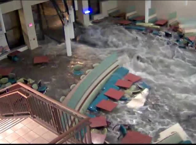
| August was Wet! Kearney, Nebraska Flooding - August 8-9th, 2014 | ||
|
|
||
|
Video from Good Samaratin Hospital Camera |
||
| Flood waters rushing into Good Samaritan Hospital in Kearney, NE made the National News in August of 2014! Heavy rainfall of 3 to 4 inches in short amount of time inundated the city of Kearney and resulted in dozens of stalled vehicles. Water broke through the windows of the dining room at Good Samaritan's Central Cafe and flooded the hospital basement, with water damage occurring in other parts of the building. August as a whole was a wet month, with Kearney receiving 7.60 inches of rain for the month, which was 4.52 inches above normal. In Hastings, NE, the total rainfall for the month was 7.79 inches, which was 4.49 inches above normal. In Grand Island, NE, August precipitation was 2.75 inches above normal with a total of 5.87 inches recorded. | ||
|
Additional Events: |
|||||
|
|
|||||
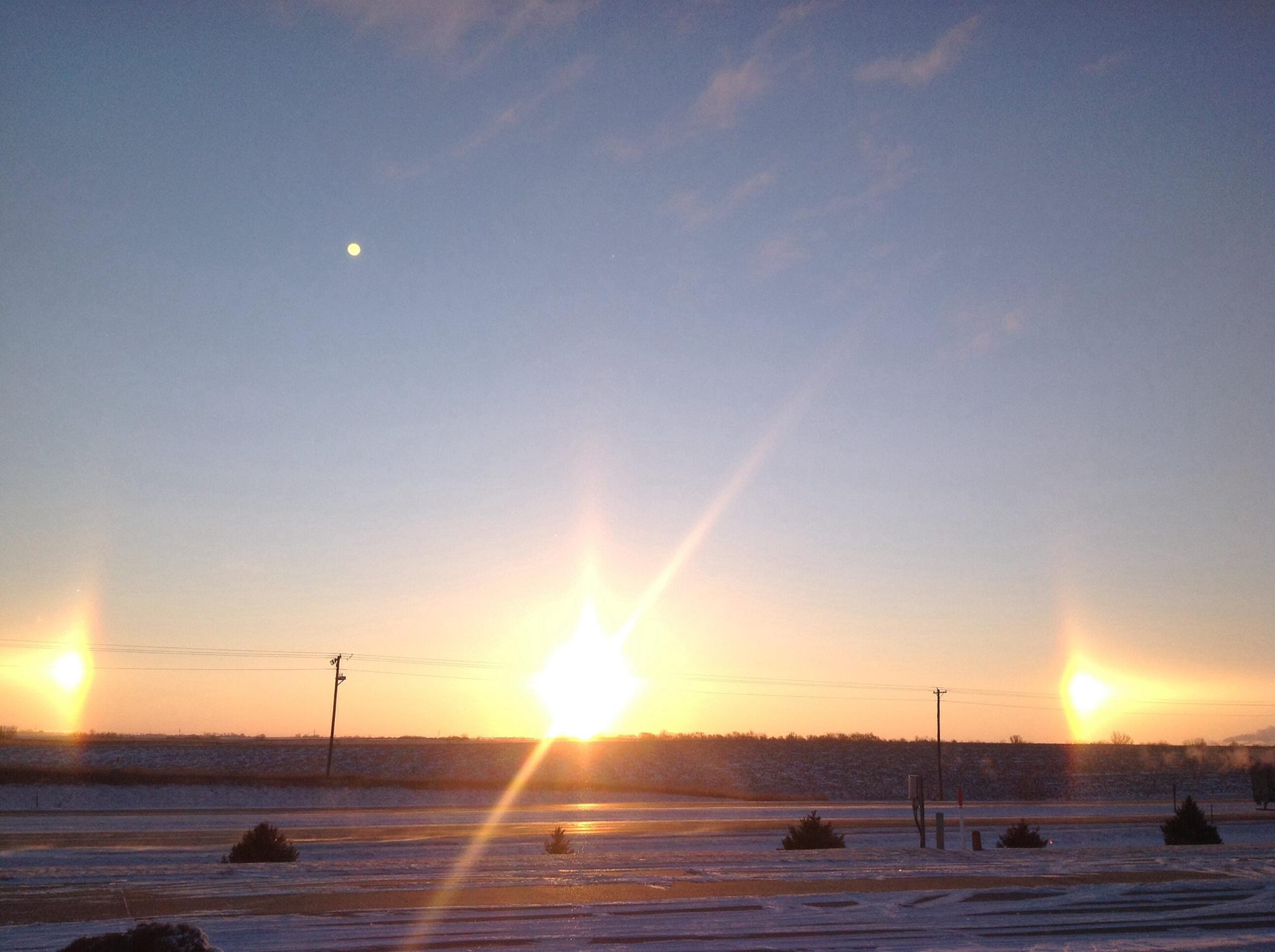
| February 5: Sundogs in the Sky | |||||
 |
|||||
| Photo by NWS Hastings Staff | |||||
|
The day after widespread snowfall of 2 to 8 inches on February 4, 2014, sun dogs were visible in the sky during the morning on February 5th. Sun dogs are a pair of bright spots on either side on the sun. They are created by light interacting with ice crystals in the atmosphere, and are best seen when the sun angle is low.
|
|||||
|
|
|||||
| July 17: Cold Air Funnel in the Grand Island & Hastings Areas | |||||
.JPG) |
|||||
|
A cold air funnel was observed by numerous people on July 17th. The funnel developed around 330 pm and lasted for at least 15 minutes. The funnel was located south of Grand Island and north of Hastings and was observed from both cities as well as from Doniphan, Hansen, and Prosser. Cold air funnels very rarely make contact with the ground and that was the case with this funnel. Cold air funnels are not associated with strong thunderstorms, but are usually reported within or near showers or very weak thunderstorms. In this case, no rainfall was associated with the cloud that produced the cold air funnel. A cool airmass was in place aloft for mid July, which made the funnel possible. Cold air funnels rarely touch down and therefore they do not typically pose a danger. If touchdowns do occur, it is usually for a only a brief period of time. |
|||||
|
|
|||||
| Monthly Climate Data: |
|
(Climate Normals based on 1981-2010 data) Please see our individual monthly summaries for additional climate information: January, February, March, April, May, June, July, August, September, October, November, December. Cooperative observer precipitation information for South Central Nebraska can be found here, and information for North Central Kansas can be found here. |
|
|
| Grand Island (Central Nebraska Regional Airport) |
|||||||||||||
| January | February | March | April | May | June | July | August | September | October | November | December | Annual | |
| Average High (F) | 38.5 | 33.5 | 51.3 | 64.2 | 76.3 | 83.6 | 84.9 | 84.5 | 76.3 | 68.7 | 47.3 | 37.1 | 62.2 |
| Average Low (F) | 12.7 | 13.4 | 23.3 | 39.0 | 49.6 | 61.8 | 61.9 | 63.8 | 52.9 | 41.1 | 21.0 | 21.1 | 38.5 |
| Average Temperature (F) | 25.6 | 23.4 | 37.2 | 51.6 | 62.9 | 72.7 | 73.4 | 74.1 | 64.6 | 54.9 | 34.2 | 29.1 | 50.3 |
| Departure from Normal (F) | +0.5 | -5.7 | -2.2 | +1.0 | +1.7 | +1.4 | -2.8 | +0.1 | -0.5 | +2.7 | -3.9 | +2.4 | -0.5 |
| Precipitation (inches) | 0.32 | 0.33 | 0.19 | 2.91 | 0.74 | 9.65 | 2.19 | 5.87 | 3.03 | 1.28 | 0.29 | 0.76 | 27.56 |
| Departure from Normal | -0.21 | -0.35 | -1.61 | +0.38 | -3.67 | +5.35 | -1.21 | +2.75 | +0.80 | -0.58 | -0.88 | +0.13 | +0.90 |
| Snowfall (inches) | 4.5 | 6.6 | 1.2 | 1.7 | 0.0 | 0.0 | 0.0 | 0.0 | 0.0 | 0.0 | 2.2 | 5.9 | 22.1 |
| Departure from Normal | -2.0 | +0.3 | -4.2 | +0.2 | 0.0 | 0.0 | 0.0 | 0.0 | -0.1 | -1.0 | -0.9 | +0.8 | -6.9 |
|
|
| Hastings (Municipal Airport) |
|||||||||||||
| January | February | March | April | May | June | July | August | September | October | November | December | Annual | |
| Average High (F) | 39.0 | 33.6 | 51.5 | 63.9 | 75.2 | 82.4 | 84.8 | 84.5 | 75.2 | 67.9 | 47.7 | 37.9 | 62.0 |
| Average Low (F) | 12.8 | 13.2 | 22.5 | 39.2 | 50.3 | 61.9 | 62.4 | 63.7 | 53.5 | 41.6 | 21.2 | 22.4 | 38.7 |
| Average Temperature (F) | 25.9 | 23.4 | 37.0 | 51.6 | 62.7 | 72.2 | 73.6 | 74.1 | 64.3 | 54.8 | 34.4 | 30.1 | 50.3 |
| Departure from Normal (F) | -0.1 | -6.5 | -2.9 | +0.9 | +1.4 | +0.4 | -3.5 | -0.2 | -1.3 | +2.2 | -4.3 | +2.5 | -1.0 |
| Precipitation (inches) | 0.37 | 0.34 | 0.15 | 3.93 | 2.15 | 8.69 | 1.48 | 7.79 | 1.78 | 1.76 | 0.23 | 0.54 | 29.21 |
| Departure from Normal | -0.04 | -0.15 | -1.64 | +1.37 | -2.42 | +4.89 | -2.26 | +4.49 | -0.78 | -0.23 | -1.06 | -0.07 | +2.10 |
| Snowfall (inches) | 5.4 | 7.5 | 1.2 | 2.2 | 0.0 | 0.0 | 0.0 | 0.0 | 0.0 | 0.0 | 1.7 | 3.4 | 21.4 |
| Departure from Normal | -0.6 | +1.0 | -4.0 | +1.0 | 0.0 | 0.0 | 0.0 | 0.0 | -0.2 | -1.0 | -0.9 | -2.7 | -7.4 |
|
|
 WFO Hastings Newsletter: The Quarterly Hail WFO Hastings Newsletter: The Quarterly Hail |
|||
|
|
|||
| Spring | Summer | Fall | Winter |


 Follow us on YouTube