National Weather Service
Radiosonde Observations
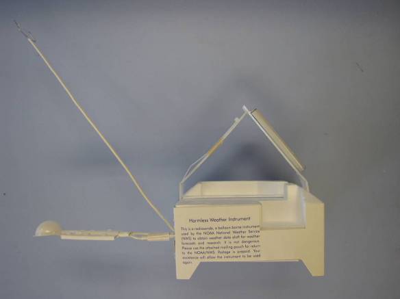
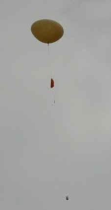
What is a radiosonde?
Less than 20 percent of the approximately 70,000 radiosondes released by the NWS each year are found and returned to the NWS for reconditioning. These rebuilt radiosondes are used again, reducing the cost of the weather balloon program.
If you find a fallen NWS radiosonde, follow the instructions on this website.
Understanding and accurately predicting changes in the atmosphere requires adequate observations of the upper atmosphere. Radiosondes provide a primary source of upper-air data and will remain so into the foreseeable future. Radiosonde observations are applied to a broad spectrum of efforts. Data applications include:
What types of radiosondes are used by the NWS?
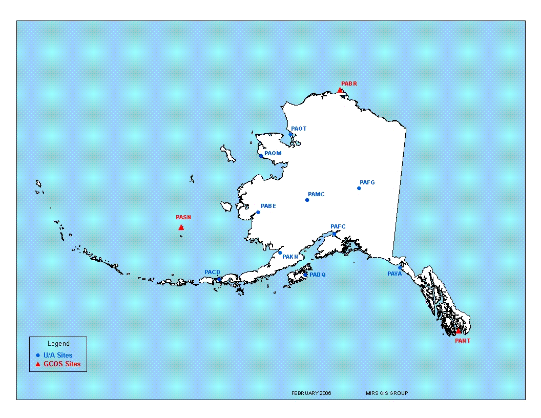
Maps showing station locations of NWS offices that take radiosonde observations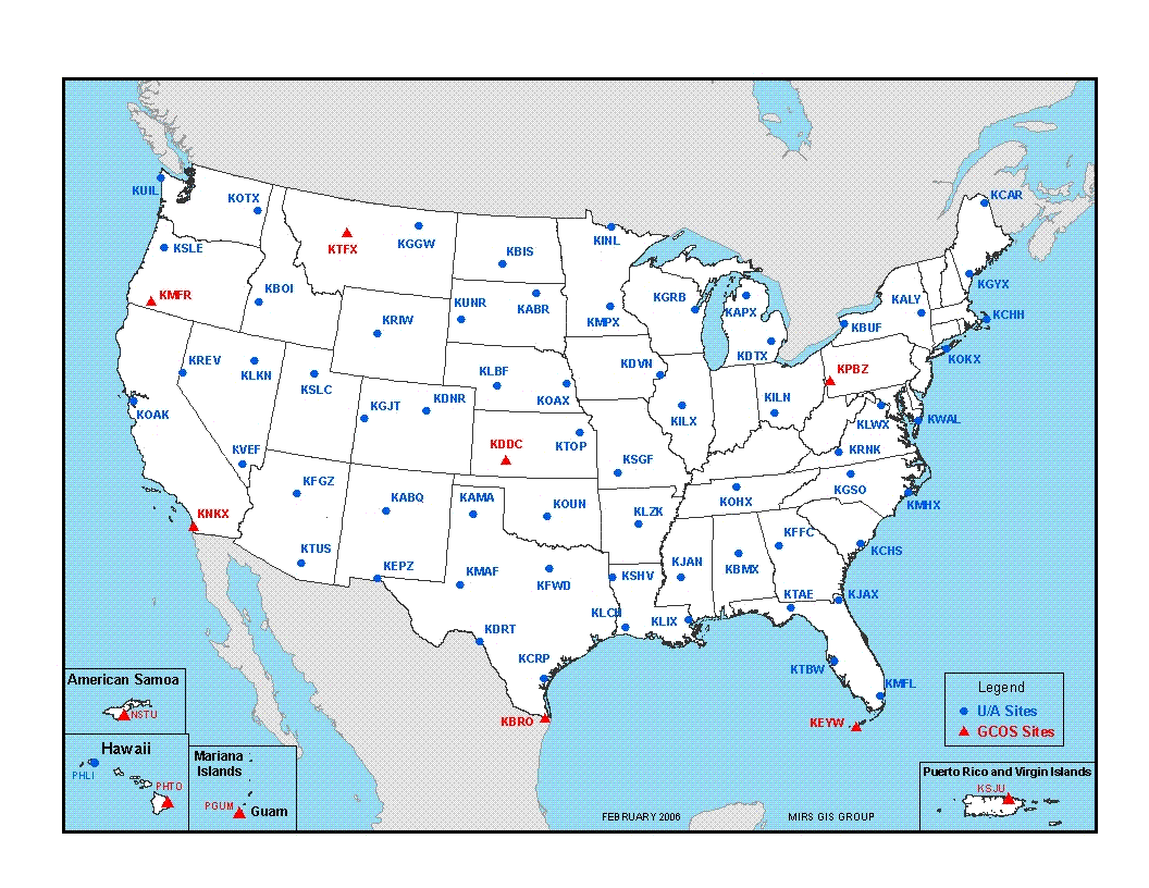
Further reading:
History of Upper-air Observations
The 18th and 19th Centuries
Upper air observations began as early as 1749 in Europe with the use of a kite to carry aloft a thermometer. A few years later, in the American Colonies, Ben Franklin conducted a very dangerous experiment by flying a kite near a thunderstorm to demonstrate the electrical nature of lightning. With the invention of hot air and hydrogen balloons in France in the early 1780's, scientists ascended aloft taking with them barometers, thermometers, and other instrumentation to investigate the structure and chemistry of the upper-atmosphere.
Manned ascents to study the upper atmosphere continued through the 1800's (and continued to the early 1960s). However, some of the early flights were very dangerous. In 1862, two men ascended to an altitude of about 11 km over Great Britain and nearly died from the extreme cold and lack of air. In a later flight taken over Europe in 1875, two French "aeronauts" died as a result of inadequate breathing equipment.
Meanwhile, the use kites for observing the upper-atmosphere continued and by the end of the 1800's kite observation stations were established by the United States Weather Bureau (National Weather Service today) and elsewhere for taking observations. The kites carried aloft meteorological instruments or "meteorographs" that recorded pressure, temperature, and relative humidity data on a clockwork driven chart recorder. Yet, use of kites had several disadvantages:
- The average altitude reached was only about 3 km.
- Data could not be evaluated until after the kite was reeled in and the meteorograph recovered.
- Observations could only be taken in good weather with winds neither too light or too strong.
- There was danger of the kite breaking away and endangering lives and property.
The early 1900's
By the end of the 1800's, meteorographs had developed to a point where they could be carried aloft by free, unmanned balloons. Such soundings reached the stratosphere that was a much greater height than that achieved with manned balloons or kites. After the balloon burst, the meteorograph returned to Earth and preserved the recorded data for days or weeks until it was found. The major drawback to this sounding approach was that the data was not readily available for weather forecasting and was lost if the meteorograph could not be recovered. A means of solving this problem was keeping the balloon captive, but this limited the maximum altitude that could be achieved.
The advent of aircraft carrying meteorographs brought an end to routine kite observations by 1933. From about 1925 to 1943 the Weather Bureau and Army Air Corps operated a network of up to 30 aircraft stations across the country that collected aircraft observations or "APOBS". However, like the kite, the aircraft could not be flown in poor weather and the data could not be analyzed until the plane landed. Furthermore, the maximum altitude achieved was only about 5 km.
To supplement the kite and aircraft data, Weather Bureau stations in 1909 began to track small, free balloons (i.e., pilot balloons) with an optical theodolite to obtain winds aloft information. At night a small light was attached to the balloon to aid tracking. Although winds aloft data could be obtained in near real-time, the balloons could only be tracked to about 5 km under good sky conditions. Moreover, when clouds or poor weather were present, sight of the balloon could be lost resulting in little or no data.
The 1930's through the 1950's
The inability of kite and aircraft meteorographs to achieve high altitudes, operate in all weather, and provide data in real-time helped foster the development for the radio transmission of upper-air data. In the late 1920's, scientists began suspending crude radio transmitters from free balloons and by the early 1930's the first radio-meteorographs or "radiosondes" were being flown into the stratosphere. In 1937 the Weather Bureau established a network of radiosonde stations that has continued to the present day. Click here to see maps of current radiosonde station locations in the United States.
World War II increased the needs for upper-air data and accelerated the development of radiosonde components and the growth of observational networks. Furthermore, advances were made in radio-direction finding or radio-theodolite technology that allowed the radiosonde to be tracked in flight so that winds aloft could be obtained. Such observations became known as "rawinsonde" observations. Initially, radio-theodolites were adjusted by hand to track the in-flight radiosonde, but by the 1950s automated radio-theodolites (ART) were implemented, which are still used today.
The early rawinsonde stations lacked computerized data processing systems, which resulted in a significant amount of manual labor and time needed to process and disseminate the upper-air data. The observation process was generally a two-person effort. However, a third person was frequently involved for quality control, general oversight of procedures, and assistance during periods of difficult weather or data analysis conditions.
It should also be noted that after World War II scientists and engineers developed Sounding Rockets, which provide scientific data well beyond the reach of balloons and into outer space. This program continues today.
The 1960's through the 1980's
To ease the workloads required for taking a rawinsonde sounding, development of computerized reduction of rawinsonde data began during the late 1960's and early 1970's. By the 1980's, technological advances in telemetry and computers made rawinsonde observations almost fully automated. This significantly reduced manual involvement in taking rawinsonde observations. In the mid-1980's the NWS made significant progress in automation. Through the use of a Personal Computer (PC) and interfaces to automatically acquire, process, and disseminate flight data, upper-air observations could be performed with minimal human intervention. The rawinsonde observation had become a one-person operation, with the time required for processing data reduced to less than 1 staff hour and with improved data quality.
In parallel with the advances in computerized data processing came new techniques for determining winds aloft. Rawinsonde systems were developed that took advantage of radio-navigation aids (NAVAID) such as LORAN and Omega (note: Omega was discontinued in October 1997). NAVAID radiosondes contain electronics that receive radio signals from fixed, ground-based transmitter stations. The radiosonde then either retransmits the received signal to the ground subsystem or processes the received signals into velocity or position information and then transmits these data. Winds aloft are contained in or derived from this information.
The 1990's and early 2000's
In the 1990's, rawinsonde technology development continued through improved radiosonde sensors, data processing, and NAVAID systems. One primary advancement was the development of rawinsonde systems that use the Global Positioning System (GPS) to determine winds aloft. Like other NAVAID systems, GPS radiosondes are equipped with a GPS receiver and associated electronics that transmit the GPS position information to the ground receiver from which winds are derived. In the late 1990's NWS began the effort to replace the current ART ground systems and associated radiosondes with GPS based systems. The first GPS based radiosonde system was installed at the upper air station in Sterling, VA, in August, 2005.
Other advances in upper-air observing technology included the development of operational remote observing systems such as wind profilers and the placement of temperature and water vapor sensors on commercial jet aircraft. that transmit these and other data in real-time. Compared to rawinsondes, these systems are capable of providing more frequent upper-air data, but with reduced vertical coverage and data resolution.
This page was originally from https://www.ua.nws.noaa.gov/factsheet.htm.


 Follow us on YouTube