Overview
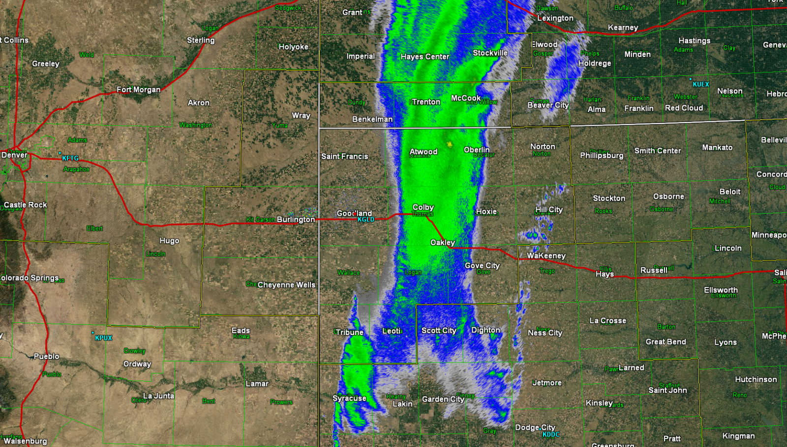
A significant spring Blizzard struck the High Plains this weekend, April 29-30, 2017. This two day event began with light snow Saturday across portions of northwest Kansas. The approaching system produced accumulating snow on Saturday mainly in portions of western and southwestern Kansas, and eastern Colorado. Snowfall extended northward also; however, areas that received one inch or less generally experienced melting due to very warm surface temperatures. Generally around four inches of snow fell by Saturday morning across Wichita and Greeley counties in northwest Kansas and in eastern Cheyenne and southeastern Kit Carson counties in Colorado. Light snow continued into the overnight hours and into Sunday before picking up in intensity and coverage as the main storm system approached the region. Heavy snow and high winds produced very low visibility on Sunday along a Tribune, KS to Oakley, KS to McCook, NE line. This band of blizzard conditions was about 100 miles across and impacted nearly all roadways east of the Colorado border to Wakeeney, KS with many roads being officially closed. Power outages were numerous as power poles snapped under the weight of heavy snow and the force of high winds upwards of 60 mph. Vehicle slide offs were common as reductions in visibility combined with slick roadways caused drivers to lose control of their vehicles. The National Guard was called into action; however, they were forced to restrict rescues to medical emergencies only due to several of their vehicles becoming stuck as well due to extreme driving conditions.
Blizzard Summary
Blizzard conditions were associated with a band of heavy snow with convective qualities that sometimes produced relatively large graupel, thunder and lightning, which was confirmed by spotters in Atwood, KS. Moisture levels were very high which led to very large snowfall totals up to 28 inches just south of Wallace in Wallace county despite low snow to liquid ratios. Winds were gusting to near or just above 60 mph in the heavier snow bands with wind gusts of near 50 mph elsewhere. Baseline winds were out of the north at a sustained 35 to 45 mph. Drifting snow was common in the spotter reports with drifts of eight to ten feet reported in Wallace, KS and widespread reports of drifts in the three to four foot range within the convective band.
The snow band started out about 100 miles across and gradually narrowed as the day progressed. As the band narrowed, it also moved north along with the upper level support provided by a low pressure system. As the lift associated with this system moved away, the snowfall ended along both the western and southeastern flank of the snow band, all the while the band slowly progressed northeast out of the region.
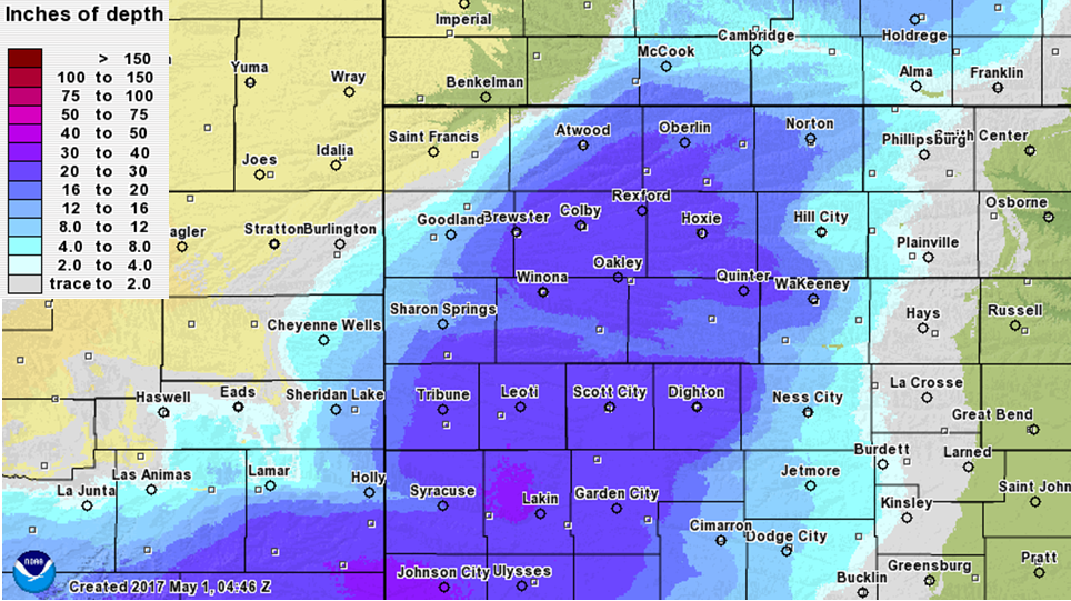
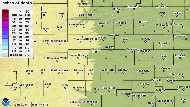
Here is an image depicting the estimated storm total snowfall from this blizzard:
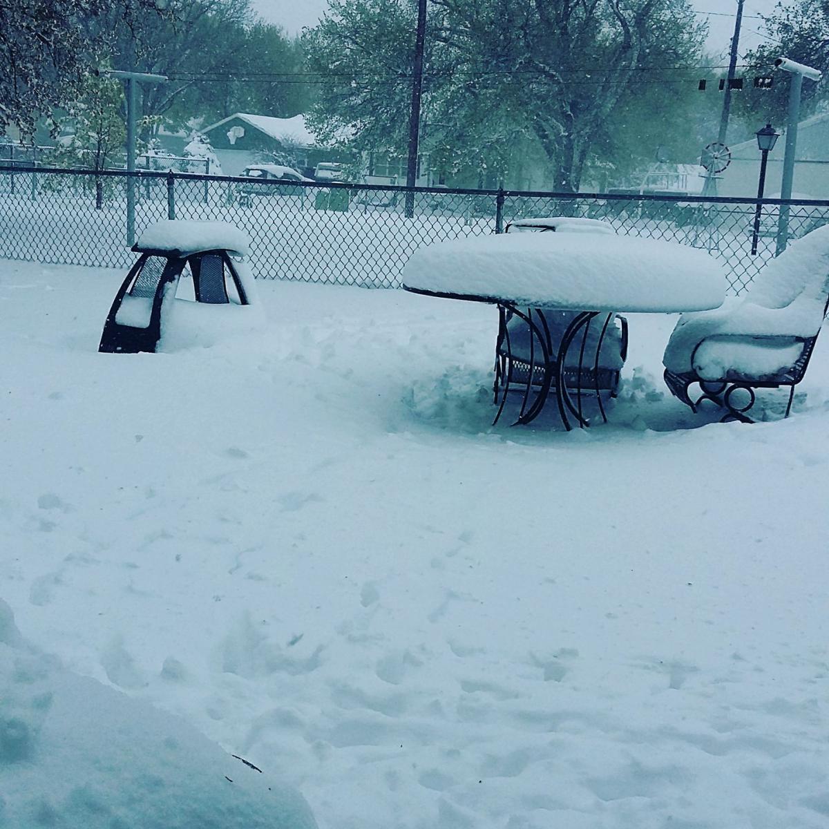
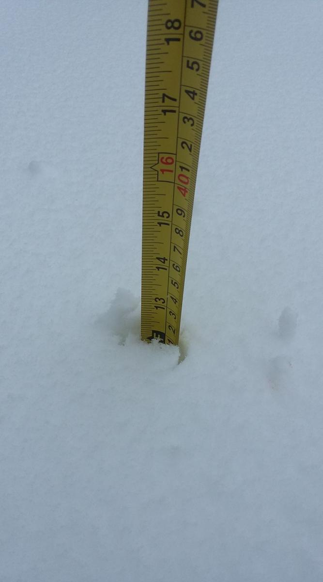
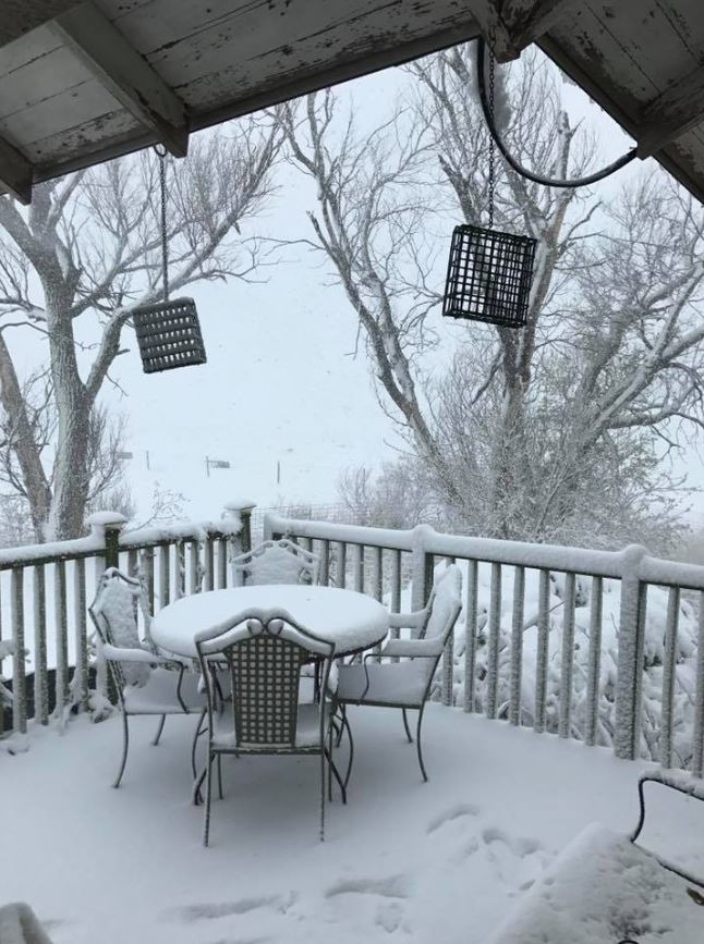
Photos & Video:
 |
 |
 |
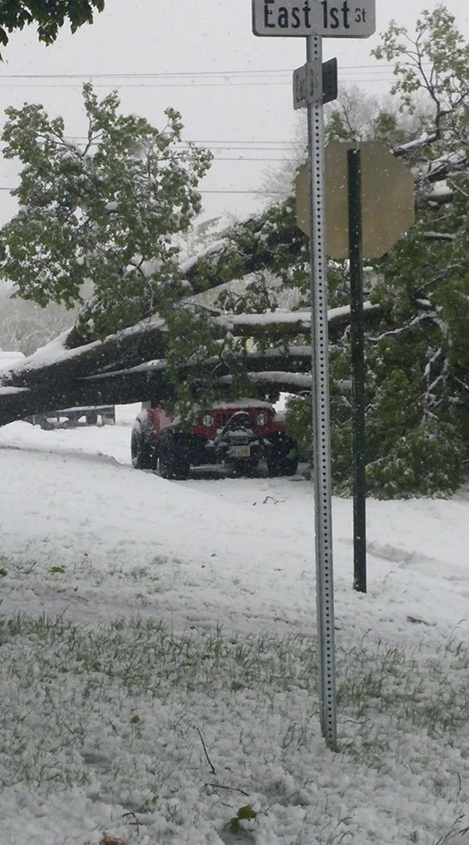
| Tree Down in McCook, NE Courtesy: Scott Mcconville |
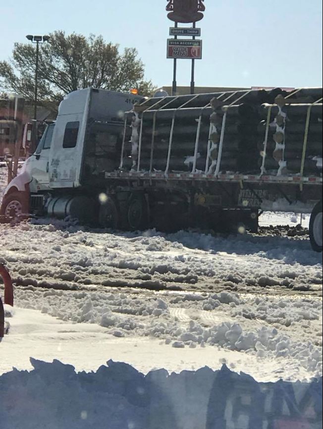
Semi stuck in Colby, Kansas Courtesy: Becky Klippert |
North of McCook, NE Courtesy: Brenda Donohue |
 |
 |
 |
| Colby, KS Courtesy: Samantha Critchfield |
Colby, Ks Courtesy: Samantha Critchfield |
North of McCook, NE Courtesy: Kathy Dueland |
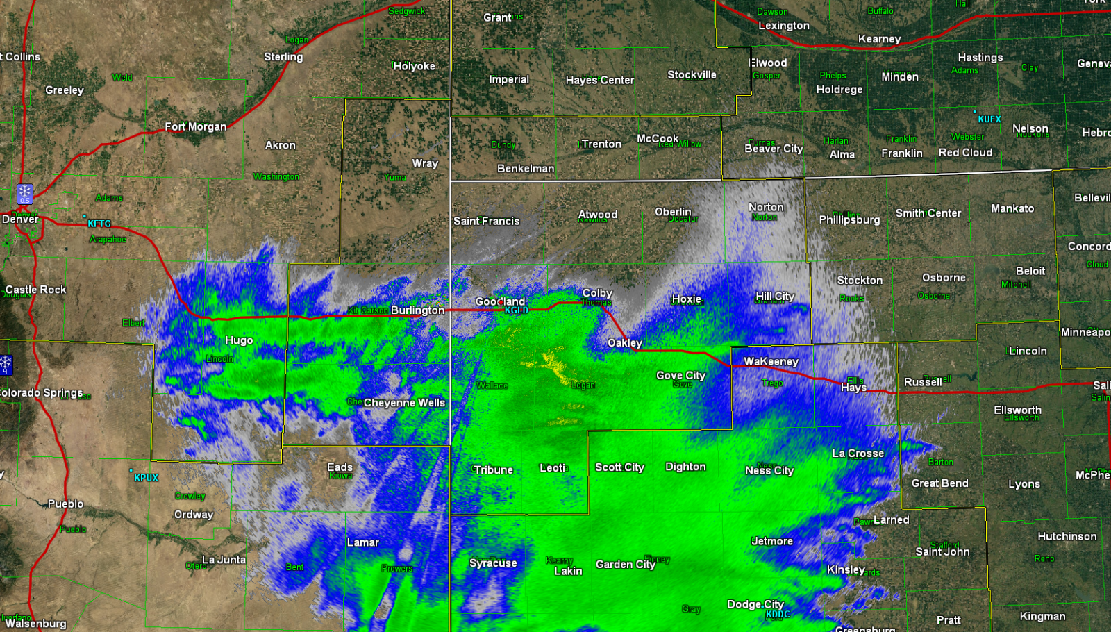
Radar and Satellite:
 |
 |
 |
 |
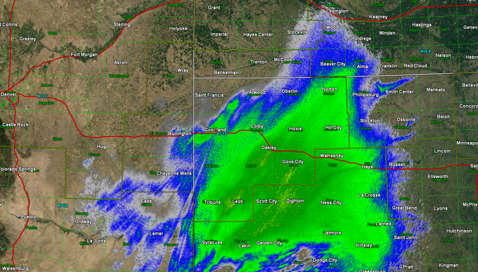
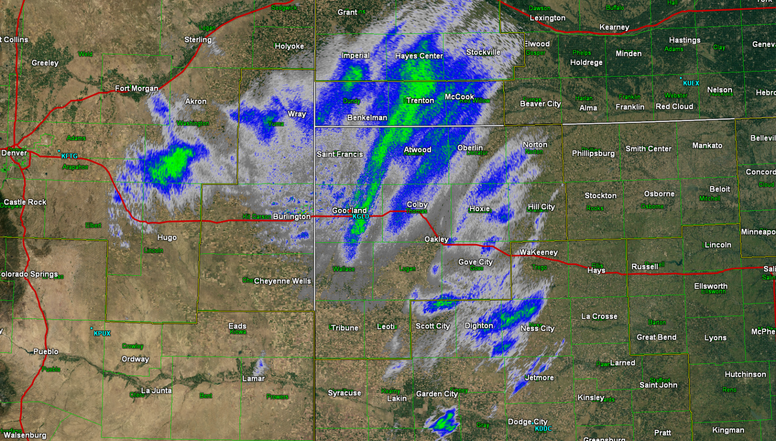
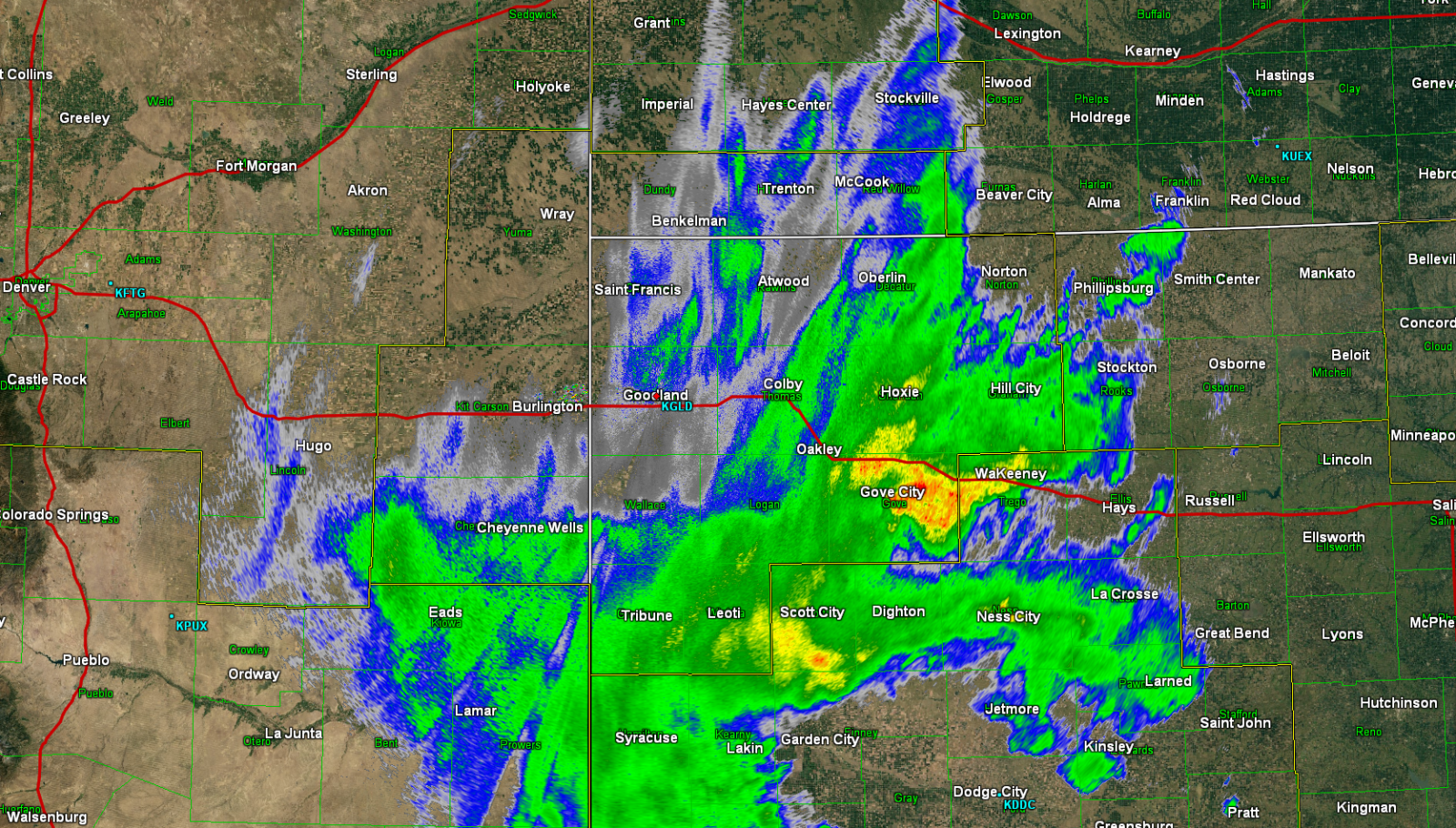
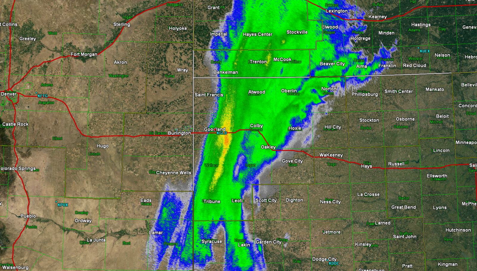
| Heavy Snow begins: 10:30 pm MT 4/28 KGLD Radar |
Heavy Snow persists: 5:00 am MT 4/29 KGLD Radar |
Initial wave of heavy snow dissipates: 1:00 pm MT 4/29 KGLD Radar |
Heavy snow begins to redevelop south of I-70: 3:30 pm MT 4/29 KGLD Radar |
 |
 |
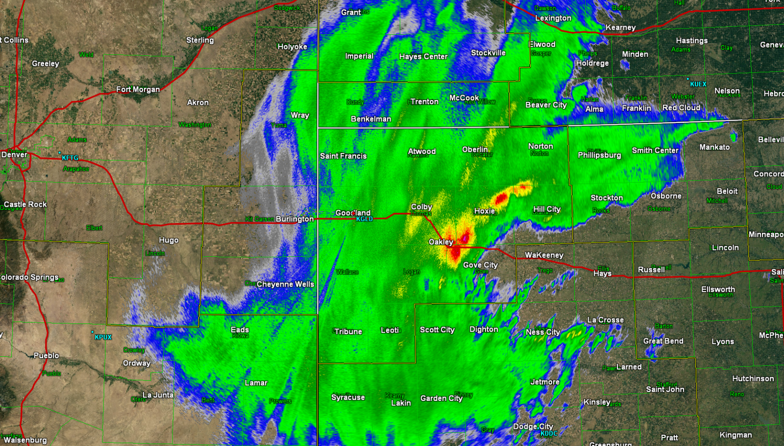 |
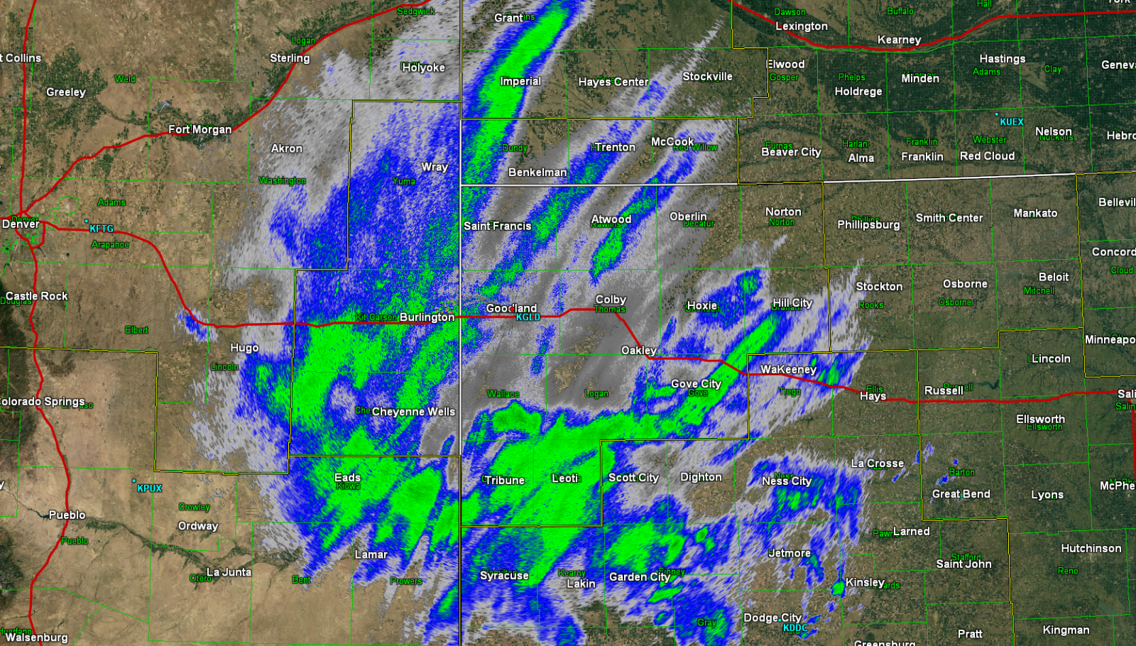
| Convection noted with heavy snow: 10:30 pm MT 4/29 KGLD Radar |
Heavy snow with embedded convection expands: 1:30 am MT 4/30 KGLD Radar |
Likely the most intense portion of the heavy snow: 4:00 am MT 4/30 KGLD Radar |
 |
 |
 |
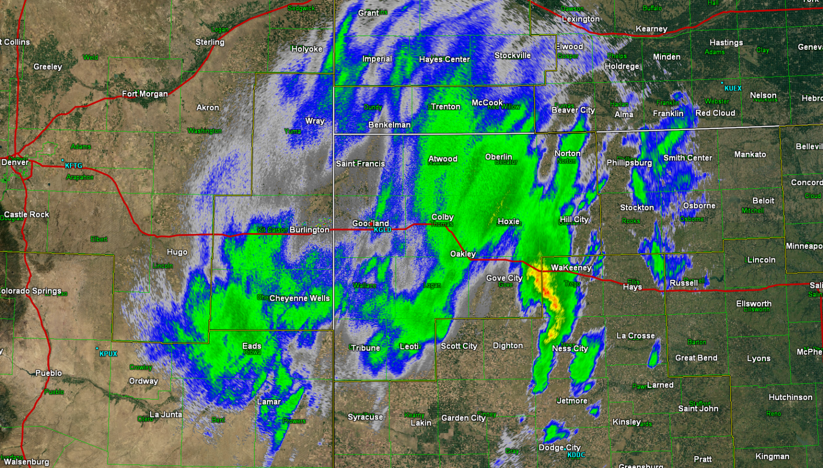
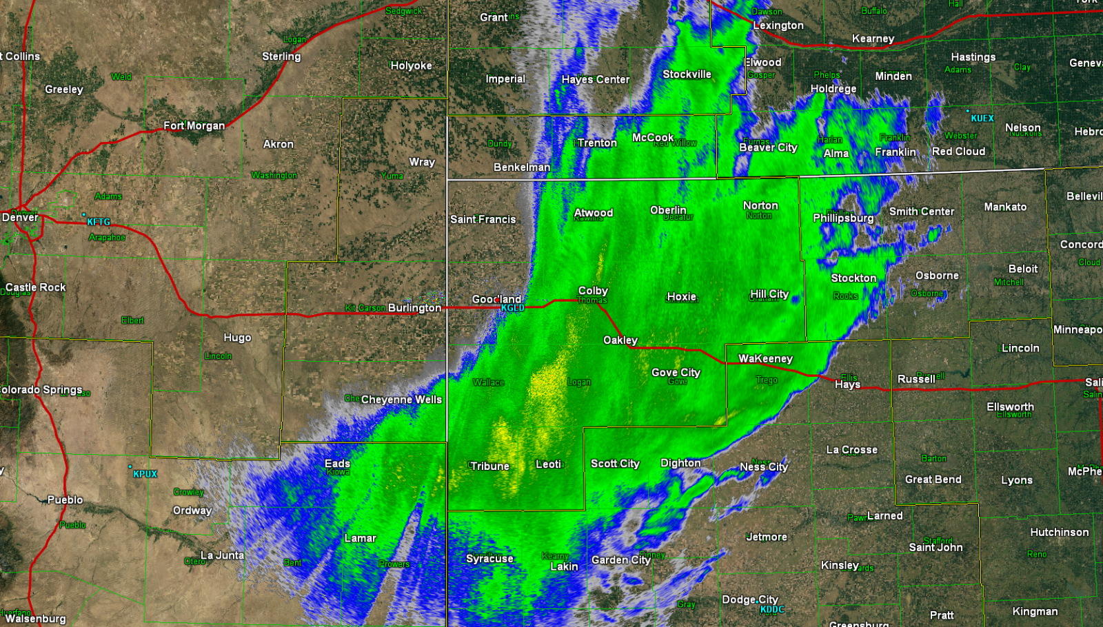
| Heavy snow persists, sharp western edge: 8:00 am MT 4/30 KGLD Radar |
Heavy snow band persists and narrows: 11:30 am MT 4/30 KGLD Radar |
Heavy snow ending, band narrows and exiting northeast: 4:00 pm MT 4/30 KGLD Radar |
 |
 |
| Loop of Snow Depth, Friday Night through Sunday National Operational Hydrologic Remote Sensing Center |
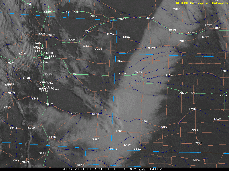
Satellite loop of remaining snow field, Monday 5/1 College of Dupage |
Storm Reports
410
NWUS53 KGLD 011938
LSRGLD
PRELIMINARY LOCAL STORM REPORT...SUMMARY
NATIONAL WEATHER SERVICE GOODLAND KS
138 PM MDT MON MAY 01 2017
..TIME... ...EVENT... ...CITY LOCATION... ...LAT.LON...
..DATE... ....MAG.... ..COUNTY LOCATION..ST.. ...SOURCE....
..REMARKS..
0717 AM SNOW 6 N WILD HORSE 38.91N 103.00W
04/29/2017 M0.7 INCH CHEYENNE CO CO-OP OBSERVER
0730 AM SNOW CHEYENNE WELLS 38.82N 102.35W
04/29/2017 M4.5 INCH CHEYENNE CO TRAINED SPOTTER
0955 AM SNOW 1 NE BURLINGTON 39.32N 102.26W
04/29/2017 M2.0 INCH KIT CARSON CO COCORAHS
0955 AM SNOW STRATTON 39.30N 102.60W
04/29/2017 M1.0 INCH KIT CARSON CO COCORAHS
0956 AM SNOW 3 S PARK 39.07N 100.36W
04/29/2017 M1.5 INCH GOVE KS COCORAHS
0957 AM SNOW OAKLEY 39.13N 100.85W
04/29/2017 M0.0 INCH LOGAN KS COCORAHS
0957 AM SNOW 8 N QUINTER 39.18N 100.23W
04/29/2017 M1.5 INCH SHERIDAN KS COCORAHS
0958 AM SNOW 10 WNW GOODLAND 39.40N 101.88W
04/29/2017 M1.0 INCH SHERMAN KS COCORAHS
0959 AM SNOW 1 ENE GOODLAND 39.35N 101.69W
04/29/2017 M0.1 INCH SHERMAN KS COCORAHS
1019 AM SNOW SHARON SPRINGS 38.89N 101.75W
04/29/2017 M2.0 INCH WALLACE KS TRAINED SPOTTER
1022 AM SNOW KIRK 39.62N 102.60W
04/29/2017 E0.0 INCH YUMA CO PUBLIC
TRACE OF SNOW
1025 AM SNOW TRIBUNE 38.47N 101.75W
04/29/2017 E2.5 INCH GREELEY KS PUBLIC
BETWEEN 2-3 INCHES
0100 PM SNOW TRIBUNE 38.47N 101.75W
04/29/2017 M6.0 INCH GREELEY KS EMERGENCY MNGR
0145 PM SNOW 13 NNE TRIBUNE 38.65N 101.66W
04/29/2017 E4.5 INCH GREELEY KS PUBLIC
ABOUT ONE QUARTER INCH MOISTURE. RELAYED VIA SOCIAL
MEDIA.
0535 PM SNOW WESKAN 38.86N 101.96W
04/29/2017 E5.0 INCH WALLACE KS LAW ENFORCEMENT
0535 PM SNOW SHARON SPRINGS 38.89N 101.75W
04/29/2017 E4.0 INCH WALLACE KS LAW ENFORCEMENT
0823 PM SNOW LEOTI 38.48N 101.36W
04/29/2017 E4.0 INCH WICHITA KS PUBLIC
RELAYED VIA SOCIAL MEDIA.
0345 AM NON-TSTM WND GST 5 ESE GOVE 38.93N 100.40W
04/30/2017 M63.00 MPH GOVE KS MESONET
PEAK SO FAR.
0410 AM NON-TSTM WND GST 3 E GRINNELL 39.12N 100.57W
04/30/2017 M57.00 MPH GOVE KS MESONET
PEAK SO FAR.
0450 AM NON-TSTM WND GST GOODLAND 39.35N 101.71W
04/30/2017 M58.00 MPH SHERMAN KS ASOS
0458 AM NON-TSTM WND GST COLBY 39.39N 101.05W
04/30/2017 M58.00 MPH THOMAS KS AWOS
WIND GUST OF 58 MPH MEASURED IN COLBY.
0511 AM NON-TSTM WND GST 1 W MONUMENT 39.10N 101.02W
04/30/2017 M57.00 MPH LOGAN KS MESONET
PEAK SO FAR.
0526 AM NON-TSTM WND GST 2 ENE COLBY 39.40N 101.01W
04/30/2017 M64.00 MPH THOMAS KS MESONET
PEAK SO FAR.
0535 AM SNOW OAKLEY 39.13N 100.85W
04/30/2017 E4.0 INCH LOGAN KS EMERGENCY MNGR
AVERAGE SNOW DEPTH AROUND 4 INCHES.
0600 AM BLIZZARD 11 N LEOTI 38.64N 101.36W
04/30/2017 WICHITA KS PUBLIC
COULD ONLY SEE A BLOCK OR SO.
0600 AM SNOW COLBY 39.39N 101.05W
04/30/2017 E6.0 INCH THOMAS KS EMERGENCY MNGR
0600 AM BLIZZARD OAKLEY 39.13N 100.85W
04/30/2017 LOGAN KS EMERGENCY MNGR
WHITE OUT CONDITIONS WEST OF OAKLEY OUTSIDE OF TOWN.
0610 AM NON-TSTM WND DMG OAKLEY 39.13N 100.85W
04/30/2017 LOGAN KS EMERGENCY MNGR
TREE BRANCHES DOWN ACROSS OAKLEY FROM STRONG WINDS.
BRANCH SIZE RANGED FROM 2 TO 9 INCHES. ONE 8 INCH
DIAMETER TREE DOWN.
0615 AM SNOW COLBY 39.39N 101.05W
04/30/2017 E4.0 INCH THOMAS KS EMERGENCY MNGR
EM ESTIMATED THAT THEY HAD RECEIVED 4 INCHES OF SNOW IN
COLBY.
0625 AM NON-TSTM WND GST 1 N GOODLAND 39.36N 101.71W
04/30/2017 M60.00 MPH SHERMAN KS ASOS
PEAK SO FAR.
0630 AM BLIZZARD 2 N GOODLAND 39.38N 101.71W
04/30/2017 SHERMAN KS NWS EMPLOYEE
WHITEOUT CONDITIONS JUST NORTH OF TOWN.
0700 AM SNOW 1 SSW NORTON 39.82N 99.90W
04/30/2017 E0.0 INCH NORTON KS COCORAHS
SPOTTER REPORTS POWER OUTAGES AND HIGH WINDS AT THE TIME
OF OBSERVATION.
0700 AM BLIZZARD TRIBUNE 38.47N 101.75W
04/30/2017 GREELEY KS AWOS
1/4 MILE VISIBILITY WITH GUSTS OF 37 MPH.
0708 AM NON-TSTM WND GST 1 N GOODLAND 39.36N 101.71W
04/30/2017 M59.00 MPH SHERMAN KS ASOS
PEAK GUST SO FAR.
0737 AM BLIZZARD 4 W OAKLEY 39.13N 100.93W
04/30/2017 LOGAN KS CO-OP OBSERVER
WHITEOUT CONDITIONS. POWER OUT SINCE 4 AM CT.
0750 AM SNOW N NORTON 39.84N 99.89W
04/30/2017 M1.5 INCH NORTON KS COCORAHS
STRONG WINDS AT OBSERVATION TIME.
0817 AM SNOW OAKLEY 39.13N 100.85W
04/30/2017 E6.0 INCH LOGAN KS PUBLIC
6 INCHES OF SNOW ON SIDE OF TREE ON NORTH SIDE OF TOWN.
TOWN STILL WITHOUT POWER.
0817 AM BLIZZARD OAKLEY 39.13N 100.85W
04/30/2017 LOGAN KS PUBLIC
NEAR WHITEOUT CONDITIONS ON NORTH SIDE OF TOWN.
0825 AM SNOW ATWOOD 39.81N 101.04W
04/30/2017 E2.0 INCH RAWLINS KS TRAINED SPOTTER
SPOTTER ALSO REPORTED GRAUPEL OR SOFT HAIL LIKE SNOWBALLS
ABOUT 1.25 INCHES IN DIAMETER WITHIN THE HEAVY SNOW BAND.
0918 AM BLIZZARD 1 W NORTON 39.84N 99.91W
04/30/2017 NORTON KS LAW ENFORCEMENT
VISIBILITY LESS THAN ONE QUARTER MILE COMBINED WITH HEAVY
SNOW. SNOW BEGINNING TO ACCUMULATE QUICKLY.
0930 AM BLIZZARD MCCOOK 40.20N 100.62W
04/30/2017 RED WILLOW NE ASOS
QUARTER MILE VISIBILITY WITH GUSTS OF 32 MPH AND A PEAK
GUST OF 43 MPH.
0931 AM BLIZZARD OAKLEY 39.13N 100.85W
04/30/2017 LOGAN KS EMERGENCY MNGR
NEAR WHITEOUT CONDITIONS IN TOWN.
0931 AM SNOW OAKLEY 39.13N 100.85W
04/30/2017 E8.0 INCH LOGAN KS EMERGENCY MNGR
NUMEROUS SLIDE OFFS IN LOGAN/GOVE COUNTIES.
0942 AM BLIZZARD SELDEN 39.54N 100.57W
04/30/2017 SHERIDAN KS EMERGENCY MNGR
VISIBILITY DOWN TO A BLOCK AND A HALF. MANY VEHICLES
STUCK/SLID OFF OF HIGHWAY 24.
0953 AM BLIZZARD COLBY 39.39N 101.05W
04/30/2017 THOMAS KS EMERGENCY MNGR
VISIBILITY LESS THAN 75 FEET IN TOWN.
0953 AM SNOW COLBY 39.39N 101.05W
04/30/2017 E17.0 INCH THOMAS KS EMERGENCY MNGR
MEASURED 14-20 INCHES. NOT MUCH DRIFTING.
0959 AM NON-TSTM WND GST TRIBUNE 38.47N 101.75W
04/30/2017 M58.00 MPH GREELEY KS AWOS
OCCURRED WITH BLIZZARD CONDITIONS.
0959 AM BLIZZARD TRIBUNE 38.47N 101.75W
04/30/2017 GREELEY KS AWOS
BELOW QUARTER MILE VISIBILITY REPORTED WITH HIGH WINDS.
1000 AM NON-TSTM WND DMG HOXIE 39.36N 100.44W
04/30/2017 SHERIDAN KS EMERGENCY MNGR
POWER LINES/POLES DOWN IN TOWN AND 7 WEST OF TOWN. POWER
LINES ALSO ACROSS ROAD 7 WEST OF TOWN. CREWS OUT NOW NEAR
HOXIE TRYING TO RESTORE POWER.
1000 AM SNOW SELDEN 39.54N 100.57W
04/30/2017 E7.0 INCH SHERIDAN KS PUBLIC
REPORTS OF 6-8 INCHES IN TOWN.
1000 AM NON-TSTM WND DMG 11 N LEOTI 38.64N 101.36W
04/30/2017 WICHITA KS PUBLIC
NO POWER SINCE 4 AM CT.
1015 AM SNOW OBERLIN 39.82N 100.53W
04/30/2017 E8.0 INCH DECATUR KS COUNTY OFFICIAL
REPORT OF 6 TO 8 INCHES OF SNOW WITH HIGH WINDS AND 0.25
TO 0.5 MILE VISIBILITY.
1015 AM BLIZZARD OBERLIN 39.82N 100.53W
04/30/2017 DECATUR KS COUNTY OFFICIAL
HEAVY SNOW REPORTED ALONG WITH VISIBILITY THAT IS
VARIABLE BETWEEN 0.25 AND 0.50 MILE.
1020 AM SNOW HORACE 38.48N 101.79W
04/30/2017 E10.0 INCH GREELEY KS LAW ENFORCEMENT
1020 AM BLIZZARD HORACE 38.48N 101.79W
04/30/2017 GREELEY KS LAW ENFORCEMENT
VISIBILITY OF A BLOCK. ALL HIGHWAYS CLOSED ACROSS COUNTY
DUE TO POOR DRIVING CONDITIONS. KDOT WAITING TO CLEAR
ROADS UNTIL CONDITIONS IMPROVE. NATIONAL GUARD CONTACTED
TO HELP WITH SITUATION.
1040 AM BLIZZARD 13 NNW EDISON 40.45N 99.87W
04/30/2017 GOSPER NE TRAINED SPOTTER
NEAR WHITEOUT CONDITIONS.
1045 AM SNOW 10 S SHARON SPRINGS 38.75N 101.75W
04/30/2017 E10.0 INCH WALLACE KS PUBLIC
TEN INCHES OF SNOW CURRENTLY WITH HIGHER DRIFTS. HIGH
WINDS AND NEAR ZERO VISIBILITY AT TIMES.
1045 AM BLIZZARD 10 S SHARON SPRINGS 38.75N 101.75W
04/30/2017 WALLACE KS PUBLIC
NEAR ZERO VISIBILITY AT TIMES WITH VERY HIGH WINDS AND
HEAVY SNOW.
1050 AM SNOW 1 SW HERNDON 39.90N 100.80W
04/30/2017 E4.0 INCH RAWLINS KS PUBLIC
FOUR INCHES OF SNOW REPORTED WITH 3 INCHES FALLING IN THE
LAST HOUR. VISIBILITY IS NEAR ZERO.
1050 AM BLIZZARD 1 SW HERNDON 39.90N 100.80W
04/30/2017 RAWLINS KS PUBLIC
NEAR ZERO VISIBILITY AND 3 INCHES OF SNOW IN THE LAST
HOUR. POWER IS OUT.
1108 AM NON-TSTM WND DMG GOODLAND 39.35N 101.71W
04/30/2017 SHERMAN KS NWS EMPLOYEE
GOODLAND LOST POWER.
1125 AM BLIZZARD ANGELUS 39.19N 100.69W
04/30/2017 SHERIDAN KS PUBLIC
LESS THAN QUARTER MILE VISIBILITY SEEN IN PICTURES.
1125 AM SNOW ANGELUS 39.19N 100.69W
04/30/2017 M8.0 INCH SHERIDAN KS PUBLIC
1128 AM SNOW GEM 39.43N 100.90W
04/30/2017 M10.0 INCH THOMAS KS PUBLIC
SNOWFALL AMOUNTS RANGE FROM 6-14 INCHES ON WEST SIDE OF
GEM.
1130 AM BLIZZARD HOXIE 39.36N 100.44W
04/30/2017 SHERIDAN KS EMERGENCY MNGR
ZERO VISIBILITY IN HOXIE.
1150 AM BLIZZARD 2 NNE ATWOOD 39.84N 101.03W
04/30/2017 RAWLINS KS AWOS
1/4 MILE VISIBILITY REPORTED UNDER BAND OF HEAVY SNOW.
1153 AM BLIZZARD MCCOOK 40.20N 100.62W
04/30/2017 RED WILLOW NE ASOS
LESS THAN QUARTER MILE VISIBILITY REPORTED.
1157 AM NON-TSTM WND DMG SELDEN 39.54N 100.57W
04/30/2017 SHERIDAN KS EMERGENCY MNGR
THREE INCH TREE LIMBS DOWN IN TOWN.
1157 AM NON-TSTM WND DMG 6 S HOXIE 39.27N 100.44W
04/30/2017 SHERIDAN KS EMERGENCY MNGR
POWERLINES DOWN ACROSS HIGHWAY 23 5-6 MILES SOUTH OF
TOWN.
1200 PM BLIZZARD OBERLIN 39.82N 100.53W
04/30/2017 DECATUR KS AWOS
QUARTER MILE VISIBILITY WITH WIND GUSTS OF 42 MPH.
1208 PM SNOW MCCOOK 40.20N 100.62W
04/30/2017 E3.0 INCH RED WILLOW NE PUBLIC
HEAVY SNOW STILL FALLING.
1215 PM SNOW 13 NNW EDSON 39.50N 101.63W
04/30/2017 M3.0 INCH SHERMAN KS TRAINED SPOTTER
BLIZZARD CONDITIONS.
1218 PM NON-TSTM WND DMG DANBURY 40.04N 100.40W
04/30/2017 RED WILLOW NE EMERGENCY MNGR
NUMEROUS POWER LINES SNAPPED FROM WIND AND THE WEIGHT OF
HEAVY SNOW ACROSS SOUTHEASTERN RED WILLOW COUNTY FROM
MARION TO LEBANON.
1218 PM BLIZZARD DANBURY 40.04N 100.40W
04/30/2017 RED WILLOW NE EMERGENCY MNGR
POWER POLES SNAPPED FROM TO DANBURY TO LEBANON IN SE RED
WILLOW COUNTY. MULTIPLE VEHICLE SLIDE OFFS ON AREA ROADS.
VISIBILITY 0.25 MILE OR LESS.
1232 PM SNOW 1 SW HERNDON 39.90N 100.80W
04/30/2017 M12.0 INCH RAWLINS KS FIRE DEPT/RESCUE
MEASURED 6-8 ADDITIONAL INCHES IN LAST 90 MINUTES. TOTAL
SNOWFALL OF 12 INCHES. STILL HEAVY SNOW OCCURRING.
1240 PM SNOW CULBERTSON 40.23N 100.84W
04/30/2017 M3.0 INCH HITCHCOCK NE EMERGENCY MNGR
1240 PM BLIZZARD CULBERTSON 40.23N 100.84W
04/30/2017 HITCHCOCK NE EMERGENCY MNGR
VISIBILITY INTERMITTENTLY DROPPING TO 0.33 TO 0.25 MILE.
MULTIPLE SLIDE OFFS REPORTED.
1246 PM BLIZZARD 7 NW HOXIE 39.43N 100.53W
04/30/2017 SHERIDAN KS PUBLIC
NEAR ZERO VISIBILITY. VEHICLES STRANDED ON ROADS.
1247 PM SNOW 11 NW COLBY 39.50N 101.19W
04/30/2017 M10.0 INCH THOMAS KS PUBLIC
STILL HEAVY SNOWFALL OCCURRING.
0127 PM NON-TSTM WND DMG MCCOOK 40.20N 100.62W
04/30/2017 RED WILLOW NE PUBLIC
TREES DOWN IN MCCOOK. RELAYED VIA SOCIAL MEDIA. PICTURE
INCLUDED.
0138 PM BLIZZARD 2 N ATWOOD 39.84N 101.04W
04/30/2017 RAWLINS KS AWOS
LESS THAN 1/4 MILE VISIBILITY AND GUSTS 35 MPH.
0153 PM BLIZZARD MCCOOK 40.20N 100.62W
04/30/2017 RED WILLOW NE ASOS
1/4 MILE VISIBILITY GUSTS OF 46 MPH.
0239 PM SNOW NORTON 39.84N 99.89W
04/30/2017 M4.0 INCH NORTON KS COCORAHS
THREE INCHES IN THE PAST 6 HOURS, FOUR INCHES TOTAL
ACCUMULATION.
0323 PM SNOW 13 NNW EDSON 39.50N 101.63W
04/30/2017 M5.0 INCH SHERMAN KS TRAINED SPOTTER
STORM TOTAL.
0415 PM SNOW HERNDON 39.91N 100.79W
04/30/2017 E14.0 INCH RAWLINS KS FIRE DEPT/RESCUE
0415 PM NON-TSTM WND DMG HERNDON 39.91N 100.79W
04/30/2017 RAWLINS KS FIRE DEPT/RESCUE
MANY POWER LINES DOWN ALL OVER TOWN.
0430 PM SNOW LEOTI 38.48N 101.36W
04/30/2017 M14.0 INCH WICHITA KS PUBLIC
AVERAGE MEASUREMENT. RELAYED VIA SOCIAL MEDIA.
0630 PM SNOW OAKLEY 39.13N 100.85W
04/30/2017 E10.0 INCH LOGAN KS EMERGENCY MNGR
ESTIMATED 10 INCHES OF SNOW FROM 4 AM TO 630 PM MDT.
MEASURED 0.70 INCHES OF MOISTURE.
0645 PM NON-TSTM WND DMG OAKLEY 39.13N 100.85W
04/30/2017 LOGAN KS EMERGENCY MNGR
POWER OUTAGE ONGOING. ESTIMATES POWER WONT RETURN UNTIL
TOMORROW.
0700 AM HEAVY SNOW 7 NW ATWOOD 39.88N 101.13W
05/01/2017 M10.0 INCH RAWLINS KS TRAINED SPOTTER
HEAVY SNOWFALL OF 10 INCHES FELL. LIVING EVERGREEN TREES
AROUND 50 FEET TALL LOST MOST OF THEIR BRANCHES, AROUND
50-60 BRANCHES, WITH DIAMETERS OF 6-8 INCHES. ALSO, A
DEAD TREE THAT HAS BEEN STANDING 67 YEARS WITH A DIAMETER
OF 4.5 FEET FELL OVER. SPOTTER SAID POWER HAS BEEN OUT
SINCE NOON YESTERDAY.
0847 AM HEAVY SNOW 8 N QUINTER 39.18N 100.23W
05/01/2017 E9.0 INCH SHERIDAN KS COCORAHS
THIS IS A COCORAHS REPORT THAT COULD NOT BE SENT OUT DUE
TO NO POWER AND NO COMPUTER ACCESS. THIS IS A TOTAL FROM
SATURDAY AND SUNDAYS SNOWFALL. 9 INCHES WAS ESTIMATED BUT
DUE TO WARM GROUND TEMPERATURE SNOW DID MELT AT TIMES.
THE MOISTURE FROM THE EVENT WAS 1.76 INCHES.
0900 AM HEAVY SNOW OBERLIN 39.82N 100.53W
05/01/2017 M10.0 INCH DECATUR KS PUBLIC
MEASURED AT 5PM LOCAL TIME IN TOWN ALONG HWY 83. NOT MUCH
SNOWFALL FELL AFTER THAT TIME.
0913 AM SNOW SHARON SPRINGS 38.89N 101.75W
05/01/2017 E12.0 INCH WALLACE KS PUBLIC
0925 AM HEAVY SNOW 6 E WALLACE 38.91N 101.48W
05/01/2017 M26.0 INCH LOGAN KS EMERGENCY MNGR
MEASUREMENT TAKEN BY THE PUBLIC BUT WAS RELAYED TO THE
EMERGENCY MANAGER IN LOGAN COUNTY WHO MENTIONED THIS IS A
TRUSTED SOURCE.
0925 AM HEAVY SNOW QUINTER 39.07N 100.23W
05/01/2017 M12.0 INCH GOVE KS EMERGENCY MNGR
10-12 INCHES WERE REPORTED IN THE QUINTER AREA.
0925 AM NON-TSTM WND DMG COLBY 39.39N 101.05W
05/01/2017 THOMAS KS PUBLIC
LIVING TREE SPLIT IN HALF. LARGEST LIMB BROKEN ON THAT
TREE WAS 8 INCHES IN DIAMETER. LOCATION WAS IN CENTRAL
COLBY.
0925 AM HEAVY SNOW TRIBUNE 38.47N 101.75W
05/01/2017 M15.0 INCH GREELEY KS EMERGENCY MNGR
SNOWFALL MEASURED IN TOWN VIA LAW ENFORCEMENT. WAS
MENTIONED THAT 7 VEHICLES WERE STRANDED DURING STORM BUT
ALL PEOPLE WERE RESCUED, VEHICLES STILL STRANDED THOUGH.
MOST OF THE COUNTY STILL HAVE A POWER OUTAGE. EMERGENCY
MANAGER IN GREELEY COUNTY WAS ON HIS WAY TO LEOTI, KS IN
WICHITA COUNTY AND NOTICED POWER LINES WERE DOWN BETWEEN
SELKIRK AND LEOTI.
0925 AM HEAVY SNOW ANGELUS 39.19N 100.69W
05/01/2017 M17.0 INCH SHERIDAN KS PUBLIC
THIS WAS THE FINAL MEASUREMENT TAKEN THE MORNING AFTER
THE EVENT ON MAY 1ST.
0925 AM HEAVY SNOW OAKLEY 39.13N 100.85W
05/01/2017 M14.0 INCH LOGAN KS EMERGENCY MNGR
THIS IS THE HIGHEST SNOWFALL TOTAL REPORTED TO EM OUT OF
GOVE COUNTY. THREE ACCIDENTS ON I-70 OCCURRED MONDAY
MORNING AFTER INTERSTATE WAS OPENED BACK UP.
0933 AM SNOW MCCOOK 40.20N 100.62W
05/01/2017 E6.5 INCH RED WILLOW NE EMERGENCY MNGR
1003 AM SNOW OBERLIN 39.82N 100.53W
05/01/2017 E6.0 INCH DECATUR KS EMERGENCY MNGR
1030 AM HEAVY SNOW WALLACE 38.91N 101.59W
05/01/2017 E28.0 INCH WALLACE KS EMERGENCY MNGR
STORM TOTAL SNOW OF 24 TO 28 INCHES ESTIMATED BY
EMERGENCY MANAGER. 8 TO 10 FOOT DRIFTS ALSO REPORTED.
LOCATIONS SOUTH OF WALLACE AND SHARON SPRINGS RECEIVED
SIMILAR AMOUNTS AND IMPACTS. WIDESPREAD POWER OUTAGES.
1030 AM HEAVY SNOW SHARON SPRINGS 38.89N 101.75W
05/01/2017 E16.0 INCH WALLACE KS EMERGENCY MNGR
STORM TOTAL SNOWFALL OF 15-16 INCHES. A LOT OF WRECKS,
SLIDE OFFS, AND RESCUES WERE REPORTED. ENTIRE COUNTY WAS
WITHOUT POWER FROM EARLY SUNDAY. PORTIONS OF THE COUNTY
ARE GETTING POWER BACK AS OF 20 MINUTES AGO BUT MANY
REMAIN WITHOUT POWER.
1030 AM HEAVY SNOW WESKAN 38.86N 101.96W
05/01/2017 E8.0 INCH WALLACE KS EMERGENCY MNGR
ABOUT 8 INCHES OF SNOW FOR THE STORM TOTAL. REPORTED BY
EMERGENCY MANAGER.
1037 AM SNOW 2 N CHEYENNE WELLS 38.85N 102.35W
05/01/2017 M2.5 INCH CHEYENNE CO TRAINED SPOTTER
STORM TOTAL. RIGHT ON HIGHWAY 385.
1049 AM SNOW MORLAND 39.35N 100.07W
05/01/2017 E8.0 INCH GRAHAM KS EMERGENCY MNGR
IN THE MORELAND/PENOKEE AREA
1058 AM SNOW SELDEN 39.54N 100.57W
05/01/2017 M11.0 INCH SHERIDAN KS EMERGENCY MNGR
RANGED FROM 10-12 INCHES. AREAS ABOUT 10-12 MILES EAST
HAD AMOUNTS NEARLY HAVE OF SELDEN TOTAL
1102 AM BLIZZARD STRATTON 39.30N 102.60W
05/01/2017 KIT CARSON CO EMERGENCY MNGR
NO MAJOR ACCIDENTS REPORTED FOR THE EVENT. ONLY MINOR
FENDERBENDERS.
1103 AM BLIZZARD ATWOOD 39.81N 101.04W
05/01/2017 RAWLINS KS EMERGENCY MNGR
ACROSS THE COUNTY FOR THE STORM...4 RESCUES FOR FOLKS
STRANDED IN CARS. 40 PEOPLE SHELTERED IN PLACE IN ATWOOD.
SNOWFALL RANGED FROM 6-10 INCHES ACROSS THE AREA.
1103 AM BLIZZARD MCCOOK 40.20N 100.62W
05/01/2017 RED WILLOW NE EMERGENCY MNGR
NO ACCIDENTS REPORTED ACROSS THE COUNTY. NUMEROUS
VEHICLES OFF ROAD. 2/3RDS OF COUNTY WITHOUT POWER AT PEAK
OF EVENT. FOCUS NEAR HIGHWAY 89...SOUTHERN LOCALES AND
INDIANOLA. NUMEROUS POLES AND LINES DOWN ACROSS THE
COUNTY. EAST/WEST OREINTATED ONES WERE HIT WORST.
1106 AM BLIZZARD OBERLIN 39.82N 100.53W
05/01/2017 DECATUR KS EMERGENCY MNGR
FOR THE EVENT ACROSS THE COUNTY...NUMEROUS OUTAGES
REPORTED DUE TO POLES/LINES DOWN. CURRENT NUMBER UNKNOWN.
NO ACCIDENTS...BUT MANY CARS WERE OFF ROAD OR ABANDONED.
1108 AM BLIZZARD ST. FRANCIS 39.77N 101.80W
05/01/2017 CHEYENNE KS EMERGENCY MNGR
FOR THE EVENT ACROSS THE COUNTY...20 PEOPLE HAD TO
SHELTER IN PLACE IN BIRD CITY. STILL NUMEROUS POWER
OUTAGES ACROSS AREA WITH ST FRANCIS STILL ON GENERATOR.
3-4 INCHES FELL OVER SOUTHERN TIER...MELTED QUICKLY.
1110 AM BLIZZARD BURLINGTON 39.31N 102.27W
05/01/2017 KIT CARSON CO EMERGENCY MNGR
FOR THE EVENT ACROSS THE COUNTY...NUMEROUS TREE BRANCHES
OFF TREES BUT NO DAMAGE REPORTED. LOTS OF SLIDE OFFS ON
AREA ROADWAYS. SOME DUE TO PEOPLE IGNORING CLOSED ROAD
SIGNS ON SECONDARY ROADWAYS.
1110 AM BLIZZARD COLBY 39.39N 101.05W
05/01/2017 THOMAS KS EMERGENCY MNGR
FOR THE EVENT ACROSS THE AREA...A WARMING CENTER OPENED
UP OVERNIGHT WITH FOLKS MOVED TO HOTELS
THEREAFTER...AIDED BY THE RED CROSS. POWER OUTAGES DID
OCCUR IN COLBY...REXFORD...BREWSTER. COLBY BACK ONLINE.
COULD BE ANOTHER DAY FOR REXFORD.
1113 AM BLIZZARD HOXIE 39.36N 100.44W
05/01/2017 SHERIDAN KS EMERGENCY MNGR
FOR THE EVENT ACROSS THE COUNTY...NUMEROUS SLIDEOFFS
REPORTED. NUMEROUS POLES/LINES DOWN OR SNAPPED. AT MAX OF
STORM...150-170 RESIDENTS HAD TO SHELTER IN PLACE DUE TO
NO HEAT.
1115 AM BLIZZARD HILL CITY 39.37N 99.85W
05/01/2017 GRAHAM KS EMERGENCY MNGR
FOOR THE EVENT ACROSS THE COUNTY...SEVERAL CARS REPORTED
OFF THE ROADS. SPORADIC POWER OUTAGES REPORTED...MAINLY
FOR WESTERN PORTIONS OF THE COUNTY.
0112 PM HEAVY SNOW HOXIE 39.36N 100.44W
05/01/2017 M12.0 INCH SHERIDAN KS PUBLIC
RELAYED VIA SOCIAL MEDIA.
0217 PM     SNOW             DRESDEN                 39.62N 100.42W
05/01/2017  M15.0 INCH       DECATUR            KS   TRAINED SPOTTER

            1.46 INCHES LIQUID
 |
Media use of NWS Web News Stories is encouraged! Please acknowledge the NWS as the source of any news information accessed from this site. |
|


 Follow us on YouTube