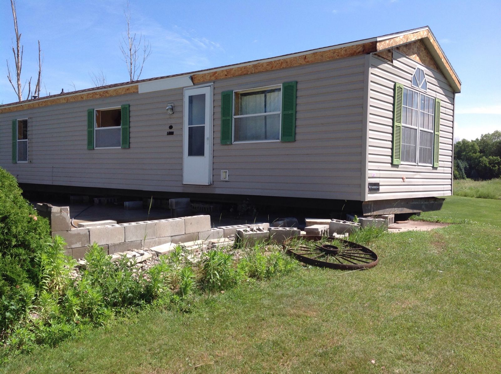
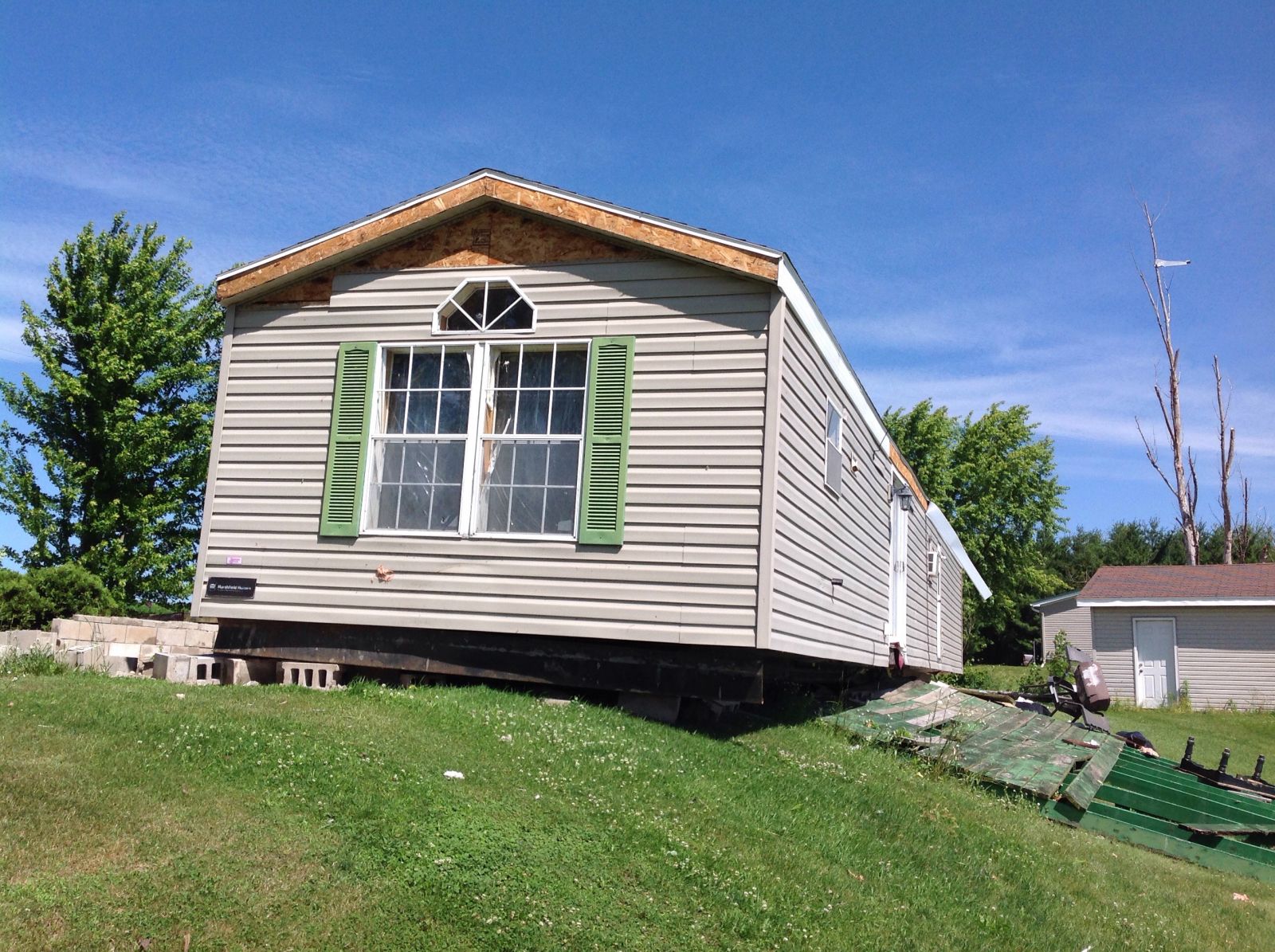
Thunderstorms with damaging winds, hail, and very heavy rain affected parts of Wisconsin during the evening of June 25 into the early morning hours of June 26 as a cold front moved across the state. The hardest hit area was along a swath that extended from northeast Waupaca County to northern Outagamie County. A tornado briefly touched down in far eastern Waupaca County between Manawa and Bear Creek. The weak tornado, with winds near 90 mph, uprooted and damaged trees along its path and slid a manufactured home off its block foundation. Several farm outbuildings were also damaged. The tornado occurred between 2:30 am and 2:35 am early Sunday morning. The damage in Outagamie County was caused by straight line ("downburst") thunderstorm winds, estimated to at least 75 mph.
Storm surveys were conducted by the National Weather Service and county emergency management officials.
| The map below shows the location of the tornado. |
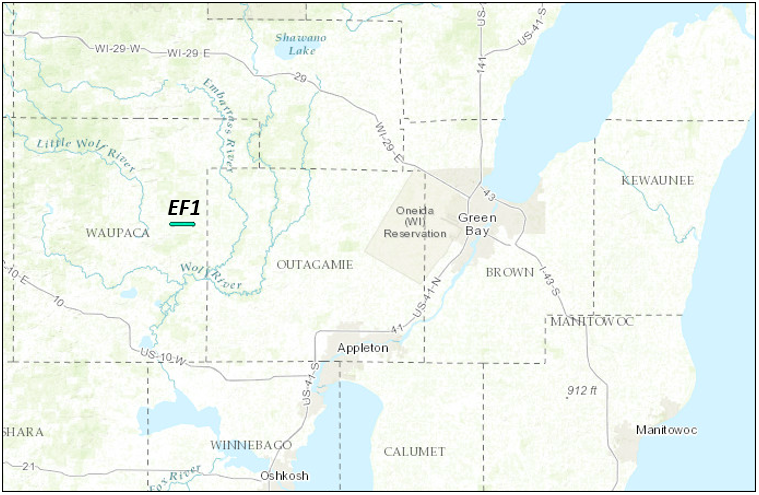 |
| Here are some damage photos from eastern Waupaca Co. | ||
 |
 |
|
 |
 |
|
Below is a radar loop of the thunderstorm line as it crossed the area. The loop is taken from the WSR-88D radar at Green Bay, and spans the time period from 8 pm Saturday evening (June 25) through 730 am Sunday morning.
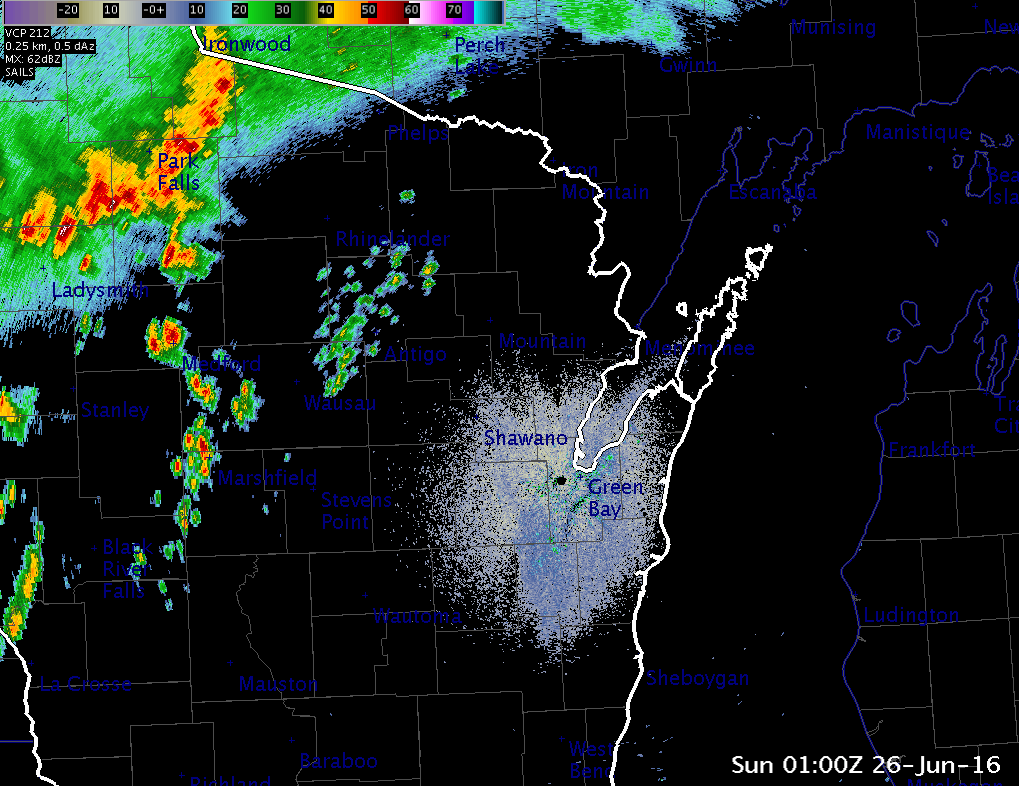 |
| Radar reflectivity loop of storms moving through the area. |
Below is a radar loop of reflectivity (top panel) and velocity (bottom panel), focused on the area with the most significant damage. The loop is taken from the WSR-88D radar at Green Bay, and spans the time period from 225 am though 319 am Sunday morning. Note the light greens and light blues in the velocity data surging eastward from just north of Sugar Bush to just north of Seymour. This is the area in which the most concentrated damage occurred.
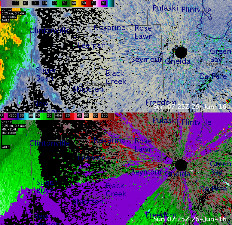 |
| Radar reflectivity (top) and velocity (bottom) loop of storms moving through eastern Waupaca and Outagamie counties. |
In addition to the wind, the storms also produced heavy rain. Below is an image of the estimated rainfall from Saturday evening through Sunday morning. The scale (in inches) is shown at the left of the image.
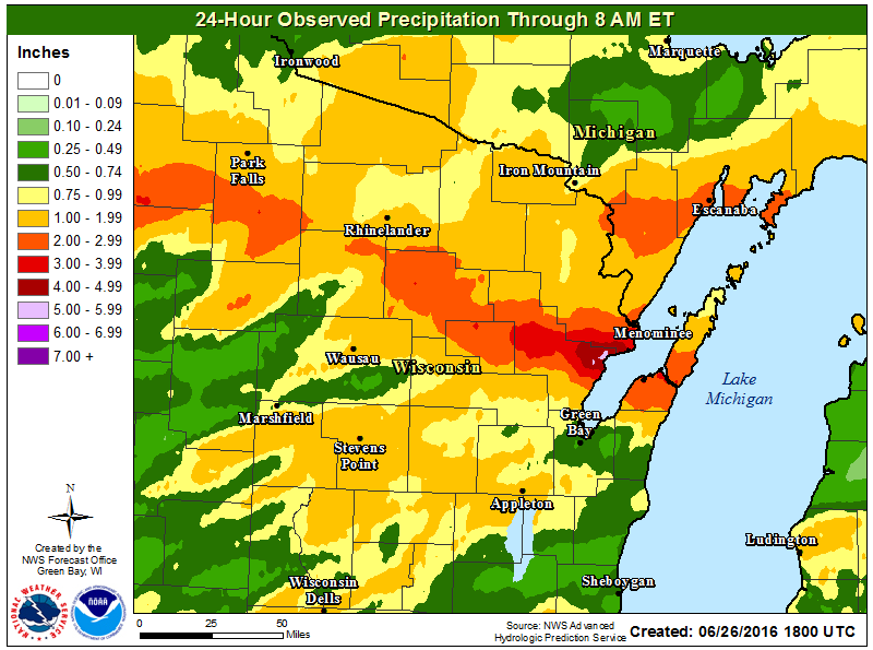 |
| Estimated rainfall Saturday evening through Sunday morning.. |
Below is a preliminary summary of storm observations from spotters, law enforcement, and the public.
PRELIMINARY LOCAL STORM REPORT...SUMMARY
NATIONAL WEATHER SERVICE GREEN BAY WI
820 AM CDT SUN JUN 26 2016

..TIME...   ...EVENT...      ...CITY LOCATION...     ...LAT.LON...
..DATE...   ....MAG....      ..COUNTY LOCATION..ST.. ...SOURCE....
            ..REMARKS..

0430 PM     TSTM WND DMG     4 W PRESQUE ISLE        46.25N 89.81W
06/25/2016                   VILAS              WI   TRAINED SPOTTER

            TREES DOWN ON COUNTY W

0820 PM     TSTM WND DMG     PRESQUE ISLE            46.25N 89.73W
06/25/2016                   VILAS              WI   PUBLIC

            TREES DOWN. POWER OUT.

0908 PM     TSTM WND GST     THREE LAKES             45.79N 89.16W
06/25/2016  E50.00 MPH       ONEIDA             WI   TRAINED SPOTTER

            TREE BRANCHES DOWN.

0910 PM     TSTM WND DMG     3 NE MC NAUGHTON        45.77N 89.51W
06/25/2016                   ONEIDA             WI   AMATEUR RADIO

            TREES DOWN.

0958 PM     HAIL             3 W MONICO              45.58N 89.17W
06/25/2016  E0.25 INCH       ONEIDA             WI   PUBLIC

1110 PM     HAIL             2 SSW BLACK CREEK       44.43N 88.45W
06/25/2016  E1.00 INCH       OUTAGAMIE          WI   AMATEUR RADIO

0206 AM     HEAVY RAIN       S PLOVER                44.45N 89.53W
06/26/2016  M1.17 INCH       PORTAGE            WI   CO-OP OBSERVER

            SO FAR THIS MORNING.

0235 AM     TSTM WND DMG     3 SW BEAR CREEK         44.50N 88.75W
06/26/2016                   WAUPACA            WI   LAW ENFORCEMENT

            TRAILER PUSHED OFF FOUNDATION. PART OF ROOF BLOWN OFF.

0240 AM     TSTM WND DMG     1 W BEAR CREEK          44.53N 88.73W
06/26/2016                   OUTAGAMIE          WI   LAW ENFORCEMENT

            INTERSECTION HIGHWAY 45 AND 76. TREES DOWN AND
            TRANSFORMER SNAPPED OFF.

0257 AM     HAIL             BLACK CREEK             44.46N 88.44W
06/26/2016  M0.88 INCH       OUTAGAMIE          WI   LAW ENFORCEMENT

0300 AM     TSTM WND DMG     1 W SEYMOUR             44.51N 88.35W
06/26/2016                   OUTAGAMIE          WI   LAW ENFORCEMENT

            INTERSECTION OF FRENCH ROAD AND COUNTY ROAD G. TREES
            DOWN.

0302 AM     TSTM WND DMG     1 SW SEYMOUR            44.50N 88.34W
06/26/2016                   OUTAGAMIE          WI   LAW ENFORCEMENT

            INTERSECTION OF HWY 47 AND COUNTY ROAD G. TREE BRANCHES
            DOWN AND SILO TOP SNAPPED.

0305 AM     TSTM WND DMG     1 N SEYMOUR             44.52N 88.33W
06/26/2016                   OUTAGAMIE          WI   LAW ENFORCEMENT

            INTERSECTION OF HIGHWAY 55 AND COUNTY ROAD VV. POWER
            LINES DOWN. TREES DOWN ON A HOUSE AND A CAR.

0356 AM     TSTM WND GST     CHILTON                 44.03N 88.16W
06/26/2016  M40.00 MPH       CALUMET            WI   TRAINED SPOTTER

0730 AM     HEAVY RAIN       FORESTVILLE             44.68N 87.50W
06/26/2016  M1.88 INCH       DOOR               WI   CO-OP OBSERVER

0730 AM     HEAVY RAIN       SUMMIT LAKE             45.38N 89.19W
06/26/2016  M2.98 INCH       LANGLADE           WI   CO-OP OBSERVER

0730 AM     HEAVY RAIN       SURING                  45.00N 88.38W
06/26/2016  M3.08 INCH       OCONTO             WI   CO-OP OBSERVER

0730 AM     HEAVY RAIN       ANTIGO                  45.15N 89.15W
06/26/2016  M1.74 INCH       LANGLADE           WI   CO-OP OBSERVER

0745 AM     HEAVY RAIN       CARLSVILLE              44.95N 87.34W
06/26/2016  M1.89 INCH       DOOR               WI   PUBLIC

0745 AM     HEAVY RAIN       OMRO                    44.03N 88.75W
06/26/2016  M1.74 INCH       WINNEBAGO          WI   PUBLIC

0745 AM     HEAVY RAIN       AMBERG                  45.50N 88.00W
06/26/2016  M1.72 INCH       MARINETTE          WI   PUBLIC


 Follow us on YouTube